Kentucky Bend
Coordinates: 36°32′N 89°31′W / 36.53°N 89.51°W
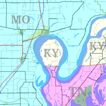
The Kentucky Bend, variously called the New Madrid Bend, Madrid Bend or Bessie Bend,[1] is an exclave of Fulton County, Kentucky, encircled by the states of Tennessee and Missouri. It is a portion of a peninsula defined by an oxbow loop meander of the Mississippi River, and its inclusion in the state of Kentucky stems from uncertainties of the course of the Mississippi River when the boundary between Tennessee and Kentucky was established.
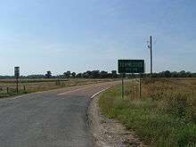
Kentucky Bend is the extreme southwestern corner of Kentucky. The peninsula includes the lowest point in the state of Kentucky, at the banks of the Mississippi River. The only highway into the area is Tennessee State Route 22, whose continuation into Kentucky Bend at one time was signed as Kentucky State Route 313.
As of the 2010 census, the population was 18 persons in this area, tabulated as the "Kentucky Bend Census County Division".[2] The mailing address of the area is Tiptonville, Tennessee, which lies to its south, although the nearest population center (and post office) is in the nearer city of New Madrid, Missouri, across the river, to its north.
Geography
According to the U.S. Census Bureau, the Kentucky Bend covers a land area of 26.9 square miles (69.6 km2), of which 17.5 square miles (45.2 km2) is land and 9.4 square miles (24.4 km2), or 35.08%, is water.[2] The water area is primarily within the Mississippi River. Surveyors marking the boundary between Kentucky and Tennessee had only estimated where their line would meet the Mississippi; later, more detailed surveys revealed the location of this line to pass through north-south bends in the river, creating a division of the peninsula.[3] The western border of Kentucky is designated as the Mississippi River, as is the eastern border of Missouri—thus the creation of a "notch" for Kentucky, but not for Tennessee.
Climate
The Kentucky Bend, as do the nearby Missouri Bootheel and Western Tennessee, has a humid subtropical climate (Köppen Cfa) with characteristics of a humid continental climate, and experiences hot, humid summers and chilly, though not severe winters. Winter weather can vary from very mild and wet when air masses from the Gulf of Mexico predominate, to very cold, dry and windy with northerly or northwesterly airflows as in the famous cold month of January 1977. On average there are 82 nights which fall to or below 32 °F or 0 °C, whilst one night falls to or below 0 °F or −17.8 °C, and the coldest temperature ever has been −17 °F or −27.2 °C on February 2, 1951. The hottest has been 107 °F or 41.7 °C record on July 1, 1952, whilst an average of 2.9 days exceed 100 °F or 37.8 °C.
Rainfall is fairly heavy throughout the year due to moist air from the Gulf of Mexico being advected on the western side of the Bermuda High, plus occasional remnant depressions from hurricanes passing up the Mississippi Valley. Between 1963 and 2012 the wettest calendar year was 1990 with 71.24 inches or 1,809.5 millimetres and the driest 2005 with 32.36 inches or 821.9 millimetres. The wettest day was September 23, 2006 with 11.38 inches (289.1 mm) in one day, and September 2006 was also the wettest month with 15.27 inches (387.9 mm), whilst no precipitation fell during October 1964.
Snowfall is common during the winter, with around 9.7 inches or 0.25 metres annually. The most snow in one month was in January 1977 with 13.1 inches or 0.33 metres, whilst the snowiest season was from July 1966 to June 1967 with 19.3 inches or 0.49 metres.
| Climate data for Kentucky Bend | |||||||||||||
|---|---|---|---|---|---|---|---|---|---|---|---|---|---|
| Month | Jan | Feb | Mar | Apr | May | Jun | Jul | Aug | Sep | Oct | Nov | Dec | Year |
| Record high °F (°C) | 78 (26) |
79 (26) |
86 (30) |
97 (36) |
98 (37) |
106 (41) |
107 (42) |
106 (41) |
104 (40) |
100 (38) |
85 (29) |
79 (26) |
107 (42) |
| Average high °F (°C) | 41 (5) |
49 (9) |
59 (15) |
70 (21) |
78 (26) |
86 (30) |
91 (33) |
90 (32) |
82 (28) |
72 (22) |
60 (16) |
47 (8) |
69 (21) |
| Average low °F (°C) | 23 (−5) |
27 (−3) |
37 (3) |
46 (8) |
56 (13) |
64 (18) |
69 (21) |
68 (20) |
60 (16) |
45 (7) |
38 (3) |
29 (−2) |
47 (8) |
| Record low °F (°C) | −20 (−29) |
−17 (−27) |
7 (−14) |
23 (−5) |
33 (1) |
43 (6) |
45 (7) |
46 (8) |
34 (1) |
23 (−5) |
5 (−15) |
−12 (−24) |
−17 (−27) |
| Average precipitation inches (mm) | 3.51 (89.2) |
4.07 (103.4) |
4.78 (121.4) |
5.01 (127.3) |
5.39 (136.9) |
4.39 (111.5) |
3.94 (100.1) |
3.23 (82) |
3.35 (85.1) |
3.64 (92.5) |
4.78 (121.4) |
5.10 (129.5) |
51.19 (1,300.3) |
| Average snowfall inches (cm) | 3.7 (9.4) |
3.4 (8.6) |
1.3 (3.3) |
0 (0) |
0 (0) |
0 (0) |
0 (0) |
0 (0) |
0 (0) |
0 (0) |
0.3 (0.8) |
1 (3) |
9.7 (25.1) |
| Source: [4] | |||||||||||||
History
The border predates the separation of Kentucky from Virginia and Tennessee from North Carolina. Its location stems from the Royal Colonial Boundary of 1665, which was meant to delimit overlapping inland claims of the Colony of Virginia and the Province of Carolina, respectively.
In 1812, this area of the river was highly disrupted and was reported to even flow backwards because of the 1811–1812 New Madrid series of earthquakes, some of the largest ever felt in the United States.[5]
The state of Tennessee contested the inclusion of the Kentucky Bend in the state of Kentucky, claiming it as part of Obion County until at least 1848, but Tennessee eventually dropped its claim.
This area of the Mississippi River, from just east at "Island Number Ten" around to the town of New Madrid, Missouri, was the site of a Civil War battle from February 28 to April 8, 1862, the Battle of Island Number Ten.
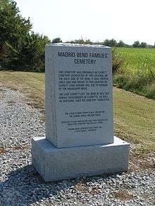
Due to its highly productive soil in the river's floodplain, Kentucky Bend was developed as a major cotton-producing area. The 1870 census recorded more than 300 residents. In The West Tennessee Farm edited by Marvin Downing (University of Tennessee at Martin Press, 1979), Norman L. Parks reports that in 1880 there was a population of 303, of whom 18 were African American. By 1900, there were "large numbers of Negroes in the Bend" working as laborers to plant and harvest the cotton.
In Mark Twain's book Life on the Mississippi,[6] he described the six-decade-long feud between the Darnell and Watson families and other elements of life in the Bend.
References
- ↑ Suhr, Jim (August 4, 2002). "Living 'Round the Bend". Columbia Daily Tribune. Retrieved January 15, 2007.
- 1 2 "Geographic Identifiers: 2010 Census Summary File 1 (G001), Kentucky Bend CCD, Fulton County, Kentucky". American FactFinder. U.S. Census Bureau. Retrieved May 25, 2016.
- ↑ "Life on the Mississippi". Kentucky Educational Television. Retrieved January 15, 2007.
- ↑ http://www.intellicast.com/Local/History.aspx?location=USTN0507
- ↑ "Kentucky Bend Map and Information Page". Worldatlas.com. Retrieved December 10, 2011.
- ↑ Twain, Mark (1883). Life on the Mississippi. Part 6. Boston: James R. Osgood & Co. Retrieved January 15, 2007 – via Project Gutenberg.
External links
- Article about Kentucky's Mississippi border
- Article on life in the Kentucky Bend
- Article on Kentucky Bend and source of its name "Bubbleland"
- Bowed Radio at the New Madrid Bend
- Google Maps link (satellite view)
Municipalities and communities of Fulton County, Kentucky, United States | ||
|---|---|---|
| Cities | 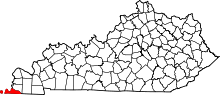 | |
| CDP | ||
| Other unincorporated communities | ||