Kleinwalsertal
| Kleinwalsertal | |
|---|---|
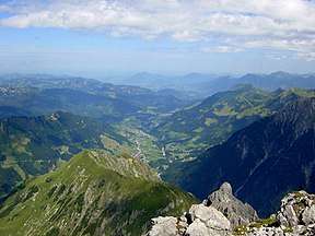 The Kleinwalsertal seen from the summit of the Widderstein | |
 | |
| Location | Mittelberg, Vorarlberg, Austria |
| Floor elevation | 1,086 m (3,563 ft) |
| Geography | |
| Coordinates | 47°20′34″N 10°10′03″E / 47.34278°N 10.16750°ECoordinates: 47°20′34″N 10°10′03″E / 47.34278°N 10.16750°E |
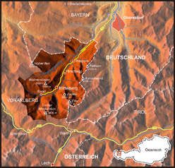
Kleinwalsertal (also little Walser valley) is a part of Mittelberg, Vorarlberg, Austria. It is part of the Bregenz district and due to the geographic location in the Allgäu Alps with its alpine terrain, the Kleinwalsertal has no direct traffic connection to the rest of Vorarlberg. It is only accessible via Oberstdorf, Germany to the north, and thus is an Austrian "practical exclave" or "pene-exclave".[1] Prior to Austria joining the European Union, the area had tax-free status.
The name of the valley comes from the Walsers who came from the Valais in the 13th century.
The valley is famous in Central Europe as a ski and hiking resort. The 5,000 inhabitants, who are called "Walser", provide 10,300 beds for tourists.
Geography
Location
The Kleinwalsertal is a high valley in the Allgäu Alps and is located in the east of Vorarlberg. The Breitach river runs through the entire valley and is fed by a few side streams, which come from the side valleys of the Kleinwalsertal.
The Kleinwalsertal is almost completely surrounded by high mountains. These are part of the Allgäu Alps, which are part of the northern eastern Alps. Its highest elevation is the Großer Widderstein (2533 m). The Kleinwalsertal is cut off from the rest of Austria. A traffic connection exists only to the Bavarian town of Oberstdorf.
Towns
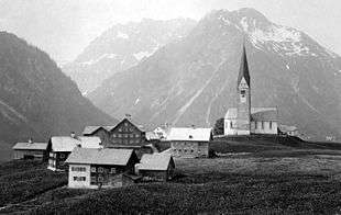
The Kleinwalsertal includes the municipality of Mittelberg and consists of three villages which are situated along the River Breitach: Mittelberg, Hirschegg and Riezlern.
The official name of this entire municipality is Mittelberg after the first populated place. On an area of 96.82 square kilometers live 4.902 inhabitants with primary residence, which results in a population density of almost 51 inhabitants per square kilometer (as of March 31, 2016).[2]
Mountains of Kleinwalsertal
- Hoher Ifen 2,230 metres (7,320 ft)
- Kanzelwand 2,058 metres (6,752 ft)
- Walmendingerhorn 1,990 metres (6,530 ft)
- Fellhorn 2,038 metres (6,686 ft)
- Elfer
- Zwölfer (Vorarlberg)
- Widderstein 2,536 metres (8,320 ft)
History
The Kleinwalsertal was populated by the Walsers in 1270, a group of people who migrated from Switzerland. This Alemannic origin still distinguishes the inhabitants from the inhabitants of the surrounding communities by their dialect.
From 1891 Kleinwalsertal enjoyed a customs union with Germany, a free border, and used the Deutsche Mark. Since Austria joined the European Union in 1995, followed by the signing of the Schengen Agreement (1997) and the introduction of the Euro (2002), this special status no longer applies.
By the time of EU accession goods from Austria had to be cleared in Germany or the import turnover tax had to be paid while German goods were free of taxes. Taxes were to be paid to the Austrian tax office in D-Mark until the introduction of the euro. A special tariff was also applied to Swiss Post. Shipments to Austria were calculated according to the domestic tariffs of Austrian Post, those to Germany were to be freed with domestic porti of the Federal Post.
Economy and Tourism
The most important industry in the last century was agriculture, which currently has only a marginal importance. Now tourism plays the major role and as early as 1960 the number of overnight stays reached a million. In 2015, there were 792.026 overnight stays in summer and 816.240 in winter of 2015/2016.[3]
The hiking and excursion tourism - especially of families with small children and seniors - is very pronounced. The choice of easy walks and moderately difficult hiking trails is correspondingly wide and well signposted. Mobility in the valley is ensured with the tightly driven Walserbus, which is free of charge to tourists paying the tourist tax via ownership of the Walsercard.
The good transport connections to the north also helped to strengthen tourism. So you only need about two and a half hours for the Stuttgart-Kleinwalsertal route.
Winter- and Summer-Tourism
Skiing is certainly the mainstay of winter tourism in the Kleinwalsertal, but it also has ski mountaineering and easy winter hiking. The great importance of tourism is also reflected in the winter sport infrastructure. The valley offers the opportunity to use 30 ski lifts, 6 chair lifts and 2 cable cars. The first mountain railway of the valley, the Kanzelwandbahn, was completed in Riezlern in 1955. The railway, renewed in 1989, transports winter sportsmen to 1957 meters above sea level. The "Kanzelwand / Fellhorn" ski area comprises 13, partly highly modern facilities.[4]
In the summer, the guests usually come for mountain hiking. There are also two very popular climbing routes (Mindelheimer Klettersteig and Zweienland Klettersteig) on the border to the neighboring commune area of Oberstdorf, which are mostly accessed via the Kleinwalsertal because of the shorter route and easier accessibility.
The conditions for sports climbing on the Hohen Ifen and the Bärenköpfle are very good. However, it is severely restricted or completely forbidden for hunting reasons.
References
- ↑ "Practical Enclaves". Enclaves of the World. Archived from the original on 8 May 2013. Retrieved 8 February 2013.
- ↑ Office of the Provincial Government of Vorarlberg, statistics department. "Inhabitants of Vorarlberg" (PDF).
- ↑ "Figures of Vorarlberg" (PDF).
- ↑ "Skiing in Kleinwalsertal on more than 128 km of ski slopes". www.kleinwalsertal.com. Retrieved 2017-07-24.