County Armagh
| County Armagh Contae Ard Mhacha (Irish) Coontie Airmagh/Coontie Armagh (Scots) | ||
|---|---|---|
| ||
 | ||
| Country | United Kingdom | |
| Region | Northern Ireland | |
| Province | Ulster | |
| Established | 1584/5 | |
| County town | Armagh | |
| Area | ||
| • Total | 512 sq mi (1,326 km2) | |
| Area rank | 27th | |
| Highest elevation (Slieve Gullion) | 1,880 ft (573 m) | |
| Population (2011) | 174,792 | |
| • Rank | 11th[1] | |
| Time zone | UTC±0 (GMT) | |
| • Summer (DST) | UTC+1 (BST) | |
| Postcode area | BT | |
| Website |
discovernorthernireland | |
| Contae Ard Mhacha is the Irish name; Coontie Armagh[2] and Coontie Airmagh[3] are Ulster Scots spellings. | ||
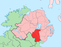
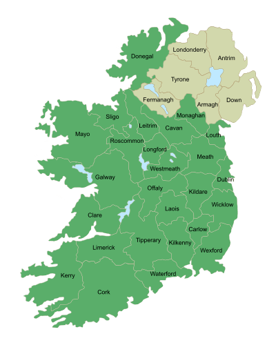
County Armagh (named after its county town, Armagh) is one of the thirty-two counties of Ireland and one of the six counties of Northern Ireland. Adjoined to the southern shore of Lough Neagh, the county covers an area of 1,326 km²[4] and has a population of about 174,792. County Armagh is known as the "Orchard County" because of its many apple orchards.[5] It is also one of the thirty-two traditional counties of Ireland, as well as part of the historic province of Ulster.
Etymology
The name "Armagh" derives from the Irish word Ard meaning "height" (or high place) and Macha. Macha is mentioned in The Book of the Taking of Ireland, and is also said to have been responsible for the construction of the hill site of Emain Macha (now Navan Fort near Armagh City) to serve as the capital of the Ulaid kings (who give their name to Ulster), also thought to be Macha's height.
Geography and features
From its highest point at Slieve Gullion, in the south of the County, Armagh's land falls away from its rugged south with Carrigatuke, Lislea and Camlough mountains, to rolling drumlin country in the middle and west of the county and finally flatlands in the north where rolling flats and small hills reach sea level at Lough Neagh.
.JPG)
County Armagh's boundary with Louth is marked by the rugged Ring of Gullion rising in the south of the county whilst much of its boundary with Monaghan and Down goes unnoticed with seamless continuance of drumlins and small lakes. The River Blackwater marks the border with County Tyrone and Lough Neagh otherwise marks out the County's northern boundary.
There are also a number of uninhabited islands in the county's section of Lough Neagh: Coney Island Flat, Croaghan Flat, Padian, Phil Roe's Flat and the Shallow Flat.
Climate
Despite lying in the east of Ireland, Armagh enjoys an oceanic climate strongly influenced by the Gulf Stream with damp mild winters, and temperate, wet summers. Overall temperatures rarely drop below freezing during daylight hours, though frost is not infrequent in the months November to February. Snow rarely lies for longer than a few hours even in the elevated south-east of the County. Summers are mild and wet and although with sunshine often interspersed with showers, daylight lasts for almost 18 hours during high-summer.
| Climate data for County Armagh | |||||||||||||
|---|---|---|---|---|---|---|---|---|---|---|---|---|---|
| Month | Jan | Feb | Mar | Apr | May | Jun | Jul | Aug | Sep | Oct | Nov | Dec | Year |
| Average high °F | 45 | 45.7 | 49.5 | 54 | 59.4 | 63.9 | 67.3 | 66.6 | 61.9 | 55 | 49.1 | 45.7 | 55.2 |
| Average low °F | 35.1 | 35.1 | 37.2 | 39 | 43.3 | 48.4 | 52.5 | 52 | 48 | 44.1 | 38.3 | 36.3 | 42.4 |
| Average precipitation inches | 3.142 | 2.264 | 2.555 | 2.181 | 2.142 | 2.193 | 2.059 | 2.831 | 2.642 | 3.193 | 2.839 | 3.283 | 29.898 |
| Average high °C | 7 | 7.6 | 9.7 | 12.2 | 15.2 | 17.7 | 19.6 | 19.2 | 16.6 | 13 | 9.5 | 7.6 | 12.9 |
| Average low °C | 1.7 | 1.7 | 2.9 | 4 | 6.3 | 9.1 | 11.4 | 11 | 9 | 6.7 | 3.5 | 2.4 | 5.8 |
| Average precipitation mm | 79.8 | 57.5 | 64.9 | 55.4 | 54.4 | 55.7 | 52.3 | 71.9 | 67.1 | 81.1 | 72.1 | 83.4 | 759.4 |
| Source: [6] | |||||||||||||
History
| Historical population | ||
|---|---|---|
| Year | Pop. | ±% |
| 1653 | 5,904 | — |
| 1659 | 6,748 | +14.3% |
| 1821 | 197,427 | +2825.7% |
| 1831 | 220,134 | +11.5% |
| 1841 | 232,393 | +5.6% |
| 1851 | 196,084 | −15.6% |
| 1861 | 190,086 | −3.1% |
| 1871 | 179,260 | −5.7% |
| 1881 | 163,177 | −9.0% |
| 1891 | 143,289 | −12.2% |
| 1901 | 125,392 | −12.5% |
| 1911 | 120,291 | −4.1% |
| 1926 | 110,070 | −8.5% |
| 1937 | 108,815 | −1.1% |
| 1951 | 114,154 | +4.9% |
| 1961 | 117,594 | +3.0% |
| 1966 | 125,164 | +6.4% |
| 1971 | 133,969 | +7.0% |
| 1981 | 133,230 | −0.6% |
| 1991 | 141,585 | +6.3% |
| 2001 | 162,957 | +15.1% |
| 2011 | 174,792 | +7.3% |
| [7][8][9][10][11][12] | ||
Ancient Armagh was the territory of the Ulaid (also known as Voluntii, Ultonians, Ulidians, Ulstermen) before the fourth century AD. It was ruled by the Red Branch, whose capital was Emain Macha (or Navan Fort) near Armagh. The site, and subsequently the city, were named after the goddess Macha. The Red Branch play an important role in the Ulster Cycle, as well as the Cattle Raid of Cooley. However, they were eventually driven out of the area by the Three Collas, who invaded in the 4th century and held power until the 12th. The Clan Colla ruled the area known as Airghialla or Oriel for these 800 years.
The chief Irish septs of the county were descendants of the Collas, the O'Hanlons and MacCanns, and the Uí Néill, the O'Neills of Fews. Armagh was divided into several baronies: Armagh was held by the O'Rogans, Lower Fews was held by O'Neill of the Fews, and Upper Fews were under governance of the O'Larkins, who were later displaced by the MacCanns. Oneilland East was the territory of the O'Garveys, who were also displaced by the MacCanns. Oneilland West, like Oneilland East, was once O'Neill territory, until it was then held by the MacCanns, who were Lords of Clanbrassil. Upper and Lower Orior were O'Hanlon territory. Tiranny was ruled by Ronaghan. Miscellaneous tracts of land were ruled by O'Kelaghan. The area around the base of Slieve Guillion near Newry also became home to a large number of the McGuinness clan as they were dispossessed of hereditary lands held in the County Down.
Armagh was the seat of St. Patrick, and the Catholic Church continues to be his see. County Armagh is presently one of four counties of Northern Ireland to have a majority of the population from a Catholic background, according to the 2011 census.
The Troubles
The southern part of the County has been a stronghold of support for the IRA, earning it the nickname "Bandit Country" though this is widely regarded as an untrue media label that has resulted in the vilification and demonisation of the local community.[13] South Armagh is predominantly nationalist, with most of the population being opposed to any form of British presence, especially that of a military nature. See Provisional IRA South Armagh Brigade for further information.
On 10 March 2009, the CIRA claimed responsibility for the fatal shooting of a PSNI officer in Craigavon, County Armagh—the first police fatality in Northern Ireland since 1998. The officer was fatally shot by a sniper as he and a colleague investigated "suspicious activity" at a house nearby when a window was smashed by youths causing the occupant to phone the police. The PSNI officers responded to the emergency call, giving a CIRA sniper the chance to shoot and kill officer Stephen Carroll.[14][15]
Administration
County Armagh is no longer used as an administrative district for local Government purposes; however, it remains officially used for purposes such as a Lieutenancy area – the county retains a lord lieutenant who acts as representative of the British Monarch in the County.[16]
County Armagh ceased to serve as a local government unit in 1973. Currently the county is covered for local government purposes by four district councils, namely Armagh City and District Council, most of Craigavon Borough Council, approximately the western third of Newry and Mourne District Council and a part of Dungannon and South Tyrone Borough Council, centred around Peatlands Park.
With the proposed reform of local government in Northern Ireland in 2011, County Armagh would have comprised part of two new council areas, Armagh City and Bann District, and Newry City and Down; however, that reform has not proceeded to date.
Armagh ceased to serve as an electoral constituency in 1983, but remains the core of the Newry and Armagh constituency represented at Westminster and the Newry and Armagh constituency represented in the Northern Ireland Assembly. County Armagh also remains as a district for legal and property purposes; however, its baronies no longer have any administrative use.
The -XZ suffix is currently used on vehicle registration plates for vehicles registered in County Armagh.
Settlements
Large towns(population of 18,000 or more and under 75,000 at 2001 Census)[17]
Medium towns(population of 10,000 or more and under 18,000 at 2001 Census)[17]
Small towns(population of 4,500 or more and under 10,000 at 2001 Census)[17]
Intermediate settlements(population of 2,250 or more and under 4,500 at 2001 Census)[17] Villages(population of 1,000 or more and under 2,250 at 2001 Census)[17]
|
Small villages or hamlets(population of fewer than 1,000 at 2001 Census)[17]
|
Subdivisions
|
Baronies 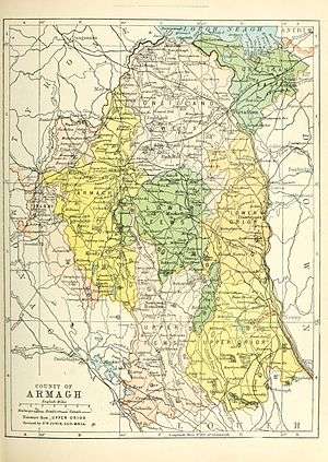 The Baronies of County Armagh (1900) Parishes Townlands
|
Transport
_-_geograph.org.uk_-_195736.jpg)
County Armagh is traversed by two major highways – the M1 linking Belfast to Dungannon crosses the north of the county whilst the A1/N1 from Belfast to Dublin runs in the far south east. Armagh has numerous local roads connecting settlements in the county.
Armagh once had a well-developed railway network with connections to, among others, Armagh City, Culloville, Goraghwood, Markethill, Vernersbridge, Tynan (see History of rail transport in Ireland ) but today only Newry (Bessbrook), Portadown, Poyntzpass, Scarva, and Lurgan are served by rail.
There is a possible railway re-opening from Portadown railway station to Armagh railway station in the future.[18] Government Minister for the Department for Regional Development, Danny Kennedy MLA indicates railway restoration plans of the line from Portadown to Armagh.[19]
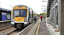
Ulsterbus provides the most extensive public transport system within the county, including frequent bus transfers daily from most towns to Belfast. Northern Ireland Railways / Iarnród Éireann's Enterprise service provides connections to Dublin in little over an hour and Belfast in little over forty minutes, several times daily.
Inland waterways
County Armagh is traversed by the Ulster Canal and the Newry Canal which are not fully open to navigation.
Sport
In association football, the NIFL Premiership, which operates as the top division, has one team in the county: Glenavon, with Portadown, Annagh United, Armagh City, Dollingstown, Loughgall and Lurgan Celtic competing in the NIFL Championship, which operates as levels two and three.
The Armagh County Board of the Gaelic Athletic Association or Armagh GAA organises Gaelic games in the county.
People associated with County Armagh
- See main article: People from County Armagh
- Frank Aiken (1898–1983), born in County Armagh, Irish Republican, Irish Minister for External Affairs, Tánaiste
- Saint Benignus of Armagh, (d. 467), first rector of the Cathedral School of Armagh and Bishop of Armagh
- Brian Boru (941–1014), buried in Armagh City, victor of Clontarf, High King of Ireland
- George Buchanan Armstrong (1822–1871), born in County Armagh, developed new system of sorting mail on trains in the United States[20]
- Sir Robert Hart (1835–1911), born in County Armagh, second Inspector-General of China's Imperial Maritime Customs Service (IMCS) from 1863 to 1911
- Arthur Hunter Palmer (1819–1898), born in County Armagh, 5th Premier of Queensland
- Samuel Knox (1756–1832), born in County Armagh, Presbyterian clergyman, school principal, and author.[21]
- Tommy Makem (1932-2007), born in County Armagh, singer, musician, and songwriter, often called "The Bard of Armagh".
- Seamus Mallon (1936– ), born in County Armagh, first deputy First Minister of Northern Ireland
- Colin Morgan (1986– ), born in County Armagh, actor
- Paul Muldoon (1951- ), born in County Armagh, poet, winner of the Pulitzer Prize for Poetry and the T. S. Eliot Prize
- Tomás Ó Fiaich (1923–1990), born in County Armagh, Cardinal (Catholicism), Catholic Archbishop of Armagh and Primate of All Ireland 1977–90
- Eunan O'Neill (1982), born in County Armagh, journalist, Russia Today
- Sir William Olpherts (1822–1902), born in County Armagh, soldier and recipient of the Victoria Cross
- Ian Paisley (1926– 2014), born in County Armagh, clergyman, politician, second First Minister of Northern Ireland
- Saint Patrick (fifth century), first Bishop of Armagh
- George William Russell 'Æ' (1867–1919), born in County Armagh, author, critic and painter
- Robert Stewart, Viscount Castlereagh (1759–1822), educated in The Royal School, Armagh. British Foreign Secretary, Secretary for War, Leader of the United Kingdom House of Commons and Chief Secretary for Ireland
- Colin Turkington (1982), born in Portadown, County Armagh, professional racing driver and 2009 British Touring Car champion.
- James Ussher (1581–1656), Church of Ireland Archbishop of Armagh and Primate of All Ireland 1625–1656
- Richard Wellesley, 1st Marquess Wellesley (1760–1842), educated in The Royal School, Armagh. Lord Lieutenant of Ireland and Governor General of India
Places of interest
- Armagh Observatory, founded in 1790 & Armagh Planetarium, a modern working astronomical research institute with a rich heritage
- Armagh Public Library on Abbey Street in Armagh City, especially rich in 17th and 18th century English books, including Dean Jonathan Swift's own copy of the first edition of his Gulliver's Travels with his manuscript corrections
- Navan Fort, now a tree ring mound which once housed the rulers of Ulster with modern interactive visitor centre
- Saint Patrick's Church of Ireland Cathedral, founded 445, seat of the Church of Ireland's Archbishop of Armagh, Primate of All Ireland, containing the grave of Brian Boru
- Saint Patrick's Roman Catholic Cathedral, commenced in 1838, seat of the Roman Catholic Archbishop of Armagh, Primate of All Ireland, stands on a hill and dominates the local countryside
- Gosford Castle, mock medieval 19th-century castle with substantial grounds
- Slieve Gullion, extinct volcano with crater lake, highest burial cairn in Ireland, views of 9 counties, with visitor centre at its foot
- Bagel Bean, Armagh's most celebrated breakfast and lunch spot. Found at two locations in the small city centre. Founded 10 years ago on Lower English Street and now also open on Market Street.
Surnames
Most common surnames in County Armagh at the time of the United Kingdom Census of 1901,[22] by order of incidence:
Gallery
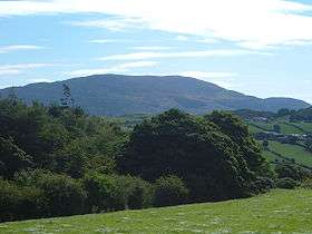 View of Slieve Gullion
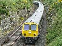 The Enterprise near Newry
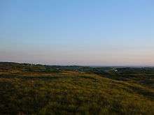 South Armagh Countryside
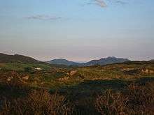 Forkhill Mountain
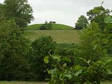
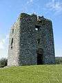 Moyry Castle
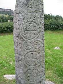 Killnasaggart Stone, 700 A.D.
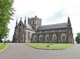 St. Patrick's Anglican Cathedral, est. 445
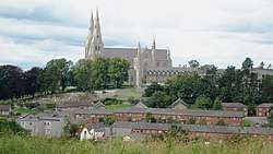
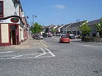 The small town of Markethill
_-_geograph.org.uk_-_1590572.jpg) Clare Glen Forest, Tandragee
Clare Glen Forest, Tandragee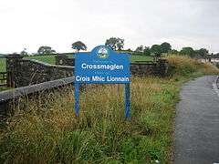 Approach to Crossmaglen
 The Knock Bridge near Portadown on the Newry Canal
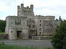 Gosford Castle,outside of Markethill
See also
| Wikimedia Commons has media related to County Armagh. |
References
- ↑ Census figures are no longer released detailing returns for Counties but rather Parliamentary Constituency, Local Government District, Electoral Ward and Output Area. This figure is based on a tally of all persons resident in the wards comprising County Armagh on 29 April 2001, i.e. all electoral wards of the Newry & Armagh Parliamentary Constituency (minus St. Mary's, St. Patrick's and Windsor Hill from County Down) combined with the 17 wards in the Upper Bann Parliamentary Constituency from County Armagh (i.e. Derrytrasna, Birches, Bleary, Drumgask, Taghnevan, Court, Annagh, Brownstown, Ballybay, Ballyoran, Corcrain, Edenderry, Killycomain, Kernan, Drumgor, Mourneview, Church, Knocknashane, Parklane, Woodville, Drumnamoe, and Tavanagh). "Area Profiles". Northern Ireland Neighbourhood Information Service. Retrieved 8 August 2008.
- ↑ Tourism Ireland: 2007 Yearly Report in Ulster Scots Archived 17 July 2012 at the Wayback Machine.
- ↑ North-South Ministerial Council: 2006 Annual Report in Ulster Scots Archived 27 February 2013 at the Wayback Machine.
- ↑ County Armagh, Land Area
- ↑ "Your Place And Mine - Armagh -". www.bbc.co.uk. Retrieved 15 March 2018.
- ↑ "Met Office". Retrieved 4 October 2008.
- ↑ For 1653 and 1659 figures from Civil Survey Census of those years, Paper of Mr Hardinge to Royal Irish Academy 14 March 1865.
- ↑ Census for post 1821 figures. Archived 9 March 2005 at the Wayback Machine.
- ↑ http://www.histpop.org Archived 7 May 2016 at the Wayback Machine.
- ↑ NISRA – Northern Ireland Statistics and Research Agency (c) 2013 Archived 17 February 2012 at the Wayback Machine.. Nisranew.nisra.gov.uk (27 September 2010). Retrieved on 23 July 2013.
- ↑ Lee, JJ (1981). "On the accuracy of the Pre-famine Irish censuses". In Goldstrom, J. M.; Clarkson, L. A. Irish Population, Economy, and Society: Essays in Honour of the Late K. H. Connell. Oxford, England: Clarendon Press.
- ↑ Mokyr, Joel; O Grada, Cormac (November 1984). "New Developments in Irish Population History, 1700–1850". The Economic History Review. 37 (4): 473–488. doi:10.1111/j.1468-0289.1984.tb00344.x.
- ↑ "Myth of Bandit Country". Armagh: Iarchimi Ard Mhacha Theas. 16 May 2014. Retrieved 16 May 2014.
- ↑ "Continuity IRA shot dead officer". London: BBC News. 10 March 2009. Retrieved 10 March 2009.
- ↑ "Continuity IRA claims PSNI murder". RTÉ News and Current Affairs. 10 March 2009. Archived from the original on 11 March 2009. Retrieved 10 March 2009.
- ↑ See the Northern Ireland (Lieutenancy) Order 1975 (SI 1975 No. 156)
- 1 2 3 4 5 6 "Statistical classification of settlements". NI Neighbourhood Information Service. Retrieved 23 February 2009.
- ↑ The Ulster Gazette. 16 May 2013
- ↑ "Kennedy has hopes for Armagh line restoration – Portadown Times". Retrieved 21 August 2013.
- ↑ Who Was Who in America, Historical Volume, 1607–1896. Marquis Who's Who. 1963.
- ↑ Ibid.
- ↑ "Armagh Genealogy Resources & Parish Registers - Ulster". forebears.co.uk. Retrieved 15 March 2018.
- Neil Lennon-former captain of Glasgow Celtic F.C. (Autobiography: Man and Bhoy)
External links
| Wikivoyage has a travel guide for County Armagh. |
- County Armagh at Curlie (based on DMOZ)
- Armagh and Down tourism
- Armagh history
- Notes on County Armagh
- Selected Monuments in County Armagh
- South Armagh - The Myth of Bandit Country
Places adjacent to County Armagh | ||||||||||
|---|---|---|---|---|---|---|---|---|---|---|
| ||||||||||
Geography of County Armagh | ||
|---|---|---|
| Cities and towns | | |
| Villages and townlands |
| |
| Landforms | ||
| Baronies | ||
| ||
The counties are listed per province | ||
 | ||
| ||
Places of Interest in County Armagh | ||
|---|---|---|
| Castles and military sites |  | |
| Churches and religious sites |
| |
| Museums and cultural sites |
| |
| Natural landmarks and outdoor spaces | ||
| Prehistoric landmarks | ||
| Stately homes |
| |
| Transport and industry |
| |
| See also | ||