Walvis Bay
| Walvis Bay Walvisbaai Walfischbucht | ||
|---|---|---|
| City | ||
| Walvis Bay | ||
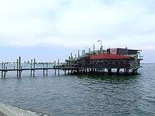
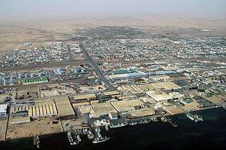 May 2005 aerial photograph of the harbour area | ||
| ||
| Nickname(s): Windwaai baai | ||
| Motto(s): In utrumque paratus (Latin = Prepared for either) | ||
 Walvis Bay Location within Namibia | ||
| Coordinates: 22°57′22″S 14°30′29″E / 22.95611°S 14.50806°ECoordinates: 22°57′22″S 14°30′29″E / 22.95611°S 14.50806°E | ||
| Country |
| |
| Region | Erongo Region | |
| Established | 1840 | |
| Government | ||
| • Mayor | Uilika Nambahu | |
| Area | ||
| • Total | 1,124 km2 (434 sq mi) | |
| Population (2011)[1] | ||
| • Total | 62,096 | |
| Time zone | UTC+2 (CAT) | |
| Climate | BWk | |
| Designations | |
|---|---|
| Designated | 23 August 1995 |
| Reference no. | 742[2] |
Walvis Bay (Afrikaans Walvisbaai, German Walfischbucht or Walfischbai, all meaning "Whale Bay") is a city[3] in Namibia and the name of the bay on which it lies. The town covers a total area of 29 square kilometres (11 sq mi) of land.[4]
The bay is a safe haven for sea vessels because of its natural deepwater harbour, protected by the Pelican Point sand spit, being the only natural harbour of any size along the country's coast. Being rich in plankton and marine life, these waters also drew large numbers of southern right whales,[5] attracting whalers and fishing vessels.
The Dutch referred to it as Walvisch Baye and the English as Whale Bay. In its eventual formal incorporation, it was named Walfish Bay, which was changed to Walvish Bay, and ultimately to Walvis Bay. It has also been referred to as Walwich Bay[6] or Walwisch Bay.[7] The Herero people of the area called it Ezorongondo.[8]
A succession of colonists developed the location and resources of this strategic harbour settlement. The harbour's value in relation to the sea route around the Cape of Good Hope had caught the attention of world powers since it was discovered by the outside world in 1485. This explains the complicated political status of Walvis Bay down the years.
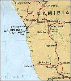
The town is situated just north of the Tropic of Capricorn in the Kuiseb River delta and lies at the end of the TransNamib Railway to Windhoek, and on B2 road.
Walvis Bay, with its large bay and sand dunes, is an important centre of tourism activity in Namibia. Attractions include the artificial Bird Island, centre of a guano collection industry, the Dune 7 sand dune, the salt works, the abundant birdlife, and a museum. Kuisebmund Stadium, home to two clubs in the Namibia Premier League, is also located in the city. The beach resort of Langstrand lies just a few kilometres north. The Walvis Bay Export Processing Zone is an important facet of the local economy.
History
Portuguese navigator Diogo Cão reached Cape Cross, north of the bay, in 1485.[9] There followed Bartolomeu Dias, who anchored his flagship São Cristóvão in what is now Walvis Bay on 8 December 1487, on his expedition to discover a sea route to the East via the Cape of Good Hope.[10] He named the bay "O Golfo de Santa Maria da Conceição."[11] However, the Portuguese did not formally stake a claim to Walvis Bay.
Little commercial development occurred on the site until the late 19th century. During the scramble for Africa, the British Empire occupied Walvis Bay with a small area surrounding the territory. They permitted the Cape Colony to complete the annexation of the territory in 1884, following initial steps which had been taken in 1878.[12]
In 1910, Walvis Bay, as part of the Cape Colony, became part of the newly formed Union of South Africa.[13] Subsequently, a dispute arose with Germany over the exclave's boundaries, which was eventually settled in 1911, with Walvis Bay being allocated an area of 1,124 square kilometres (434 sq mi).[14]
The exclave was overrun by the Germans during the South West Africa Campaign early in the First World War, but South African Forces eventually ousted the Germans in 1915.[15] Subsequently, Walvis Bay was quickly integrated into the new martial law regime established in South West Africa.[16]
South Africa was later awarded control (a Class "C" mandate) over South West Africa by the League of Nations to administer the territory.[17] Civilian rule was restored in South West Africa in 1921 and administration of Walvis Bay was transferred to South West Africa under the South West Africa Affairs Act of 1922.[18]
Despite the territory never having been part of German South West Africa, the Act stated that: "the port and settlement of Walvis Bay, which forms part of the Cape of Good Hope, shall for judicial and administrative purposes be regarded as if it were part of the mandated territory of South West Africa".[14] However, South Africa had also sought to annex South West Africa itself, and had presented such a proposal to the League of Nations.[12] Consequently, in 1949, the Act was amended to give representation in the Parliament of South Africa to whites in South West Africa.[19]
In 1977, following increasing international pressure to relinquish its control over South West Africa, South Africa repealed the Act, but transferred control of Walvis Bay back to the Cape Province, thereby making it an exclave.[20] From 1980, it was represented in both the Provincial Council and the House of Assembly as part of the Green Point constituency in Cape Town, before becoming a separate constituency in 1982.[21]
In response, the United Nations Security Council passed Resolution 432 (1978), which declared that "the territorial integrity and unity of Namibia must be assured through the reintegration of Walvis Bay within its territory".[22]
In 1990, South West Africa gained independence as Namibia, but Walvis Bay remained under South African sovereignty, with South Africa increasing the number of troops.[23] However, in 1992, the two countries agreed to establish a transitional Joint Administrative Authority for Walvis Bay and the Offshore Islands.[24] The Authority was headed by two Chief Executive Officers, Nangolo Mbumba, then Secretary to the Namibian Cabinet, and Carl von Hirschberg, former South African Ambassador to the United Nations.[25]
In August 1993, prior to the end of apartheid, the Multiparty Negotiating Forum in South Africa passed a resolution calling for "the incorporation-reintegration of Walvis Bay and the Off-Shore Islands into Namibia." [26] The Transfer of Walvis Bay to Namibia Act was passed by the Parliament of South Africa that year.[27] Following the signing of a treaty between the two countries, South Africa formally transferred sovereignty of Walvis Bay and the Penguin Islands to Namibia on 1 March 1994.[28]
Geography
Climate
Walvis Bay features the very rare mild variation of the desert climate (BWn) according to the Köppen climate classification. It is caused by the rain shadow of the Naukluft Mountains and the cooling effect of the coastal sea temperature by the Benguela Current. Walvis Bay receives only 13.2 millimetres (0.52 in) average precipitation per year, making it one of the driest cities on earth. Despite its dry climate, the city is relatively humid. Average relative humidity throughout the year remains above 80%. The warmest month is February with average temperature 17.9 °C (64.2 °F), while the coolest months are August and September with average temperature 13.2 °C (55.8 °F). The diurnal temperature range is also low, averaging only 5.7 °C (10.2 °F). As one of the effects of manmade climate change, there has also been considerable warming at the airport in recent years. On 17 May 2015, the temperature at Rooikop near Walvis Bay International Airport reached 37.4 °C.[29]
| Climate data for Pelican Point, Walvis Bay (7 m), Namibia (1958-1984) | |||||||||||||
|---|---|---|---|---|---|---|---|---|---|---|---|---|---|
| Month | Jan | Feb | Mar | Apr | May | Jun | Jul | Aug | Sep | Oct | Nov | Dec | Year |
| Record high °C (°F) | 25.3 (77.5) |
26.4 (79.5) |
34.5 (94.1) |
35.0 (95) |
36.0 (96.8) |
32.5 (90.5) |
32.9 (91.2) |
33.4 (92.1) |
31.3 (88.3) |
27.5 (81.5) |
28.3 (82.9) |
25.5 (77.9) |
36 (96.8) |
| Average high °C (°F) | 20.0 (68) |
20.3 (68.5) |
19.6 (67.3) |
18.6 (65.5) |
19.0 (66.2) |
18.8 (65.8) |
17.8 (64) |
16.4 (61.5) |
15.8 (60.4) |
16.6 (61.9) |
17.7 (63.9) |
19.0 (66.2) |
18.3 (64.9) |
| Daily mean °C (°F) | 17.6 (63.7) |
17.9 (64.2) |
17.2 (63) |
15.7 (60.3) |
15.6 (60.1) |
15.2 (59.4) |
14.1 (57.4) |
13.2 (55.8) |
13.2 (55.8) |
14.0 (57.2) |
15.3 (59.5) |
16.6 (61.9) |
15.5 (59.9) |
| Average low °C (°F) | 15.2 (59.4) |
15.5 (59.9) |
14.7 (58.5) |
12.9 (55.2) |
12.1 (53.8) |
11.4 (52.5) |
10.3 (50.5) |
10.1 (50.2) |
10.7 (51.3) |
11.5 (52.7) |
12.9 (55.2) |
14.2 (57.6) |
12.6 (54.7) |
| Record low °C (°F) | 10.5 (50.9) |
9.2 (48.6) |
10.5 (50.9) |
8.5 (47.3) |
7.0 (44.6) |
5.0 (41) |
3.4 (38.1) |
4.4 (39.9) |
6.1 (43) |
5.0 (41) |
8.5 (47.3) |
9.6 (49.3) |
3.4 (38.1) |
| Average precipitation mm (inches) | 1.0 (0.039) |
2.0 (0.079) |
5.0 (0.197) |
1.0 (0.039) |
1.0 (0.039) |
2.0 (0.079) |
0.0 (0) |
0.2 (0.008) |
0.1 (0.004) |
0.1 (0.004) |
0.7 (0.028) |
0.1 (0.004) |
13.2 (0.52) |
| Average precipitation days (≥ 0.1 mm) | 0.6 | 0.8 | 1.1 | 0.5 | 0.4 | 0.5 | 0.0 | 0.4 | 0.5 | 0.4 | 0.6 | 0.4 | 6.2 |
| Average relative humidity (%) | 87 | 87 | 89 | 89 | 86 | 81 | 82 | 86 | 89 | 88 | 88 | 88 | 87 |
| Mean monthly sunshine hours | 232 | 189 | 211 | 237 | 251 | 231 | 236 | 220 | 189 | 226 | 210 | 214 | 2,646 |
| Source #1: Deutscher Wetterdienst[30] | |||||||||||||
| Source #2: Danish Meteorological Institute[31] | |||||||||||||
Politics
Walvis Bay is governed by a municipal council that currently has ten seats.[32]
The 2015 local authority election was won by the SWAPO party which gained eight seats (5,818 votes). One seat each was won by the Democratic Turnhalle Alliance (DTA, 565 votes) and the United Democratic Front (UDF, 433 votes).[33]
Culture
Entertainment and sport
Walvis Bay contains open spaces, scenic beauty and unique marine and plant life. It is well suited for the outdoor lifestyle, boasting sports such as sandboarding, kiting, surfing, swimming, angling, sailing, golf and other indoor and outdoor sport codes. There is Walvis Bay Lagoon and Aquatic Activities, Kuiseb River Delta and the beach itself where people enjoy swimming and catching fish.
The 2-kilometre (1.2-mile) sand spit allows the adjacent water to remain smooth in very strong winds, ideal for record attempting vessels like that by the Vestas Sailrocket.[34] The ocean side of the sand spit has a world-famous surf spot known in the international surf media as "Skeleton Bay."[35]
The city is home to Eleven Arrows F.C. and Blue Waters F.C., football clubs that compete in the Namibia Premier League, and the Sparta Cricket Club Ground.[36]
Economy and infrastructure
Logistics
Walvis Bay is an important logistical port for the southern African region, providing port facilities for the import and export of cargo for the rest of Namibia, Zambia, Democratic Republic of Congo, and Botswana. Since the Walvis Bay Corridor Group (WBCG) was established in 2000, cargo moving through the port has increased from 30,000 containers a year to 370,000 containers in 2016. As of 2017 the port was being upgraded to increase its capacity to move 1 million containers a year by 2019. Bureaucratic and logistical problems at the city's competitor port at Durban, South Africa have diverted traffic to the port at Walvis Bay. Ninety-five percent of all cargo hauled overland through Walvis Bay is carried by truck.[37]
The Walvis Bay Corridor Group is gearing up to increase import/export-business opportunities in Namibia. The Namibian National Development Plan expects to complete the expansion programme of the Walvis Bay port by 2019. Because of the harbour's geographical positioning, authorities plan to gain a footprint in providing landlocked Southern African Development Community (SADC) countries with a vital logistical hub.[38] In addition to the importance of the port, development would strengthen trade corridors which consists of current road and rail networks.[38]
Fishing
In Walvis Bay there are different fishing companies like Hangana Seafood, Caroline Fishing, Benguella Fishing Company, Cadilu Fishing, Etosha Fisheries, Kuiseb Fishing Enterprises, Blue Ocean Products, Benguella Sea Products, Consortium Fisheries, Talanam Fish Processor. These companies catch different types of fish like snoek, horse mackerel, anchovy, white steenbras, kabeljou, kingklip, hake, catfish, tuna and sardines. Hangana Seafood are processors and exporters of fish and fish products. As such, the fishing enterprise accounts for a major part of Walvis Bay's economy.
In May 2018, a spokesman for the National Fishing Corporation of Namibia (Fishcor), confirmed that a new N$530 million onshore processing plant would be operational by September 2018. After completion, the factory (which plans to employ 700 people of which 70% will be female), promises to be the largest pelagic processing plant in sub-Saharan Africa and will process about 80 000 tonnes of fish per annum.[39]
Manufacturing
In March 2018 the Namibian government in association with French Groupe PSA signed an investment agreement to initiate a joint-venture to assemble Opel and Peugeot vehicles in Walvis Bay. The N$190m-project[40] has been earmarked to commence in 2018 with a forecasted annual target volume of 5000 units by 2020, a target carried by SACU* countries' market demand.[41]
Education
Walvis Bay has a number of public (government-run), semi-public, and private schools. Among them are Duneside High School, Duinesig Primary School, International School of Walvis Bay, The Dolphin Schools, Alexanders Private School, Kuisebmond Secondary School, Walvis Bay Private High School and others. A number of kindergartens cater to young children.
The Namibian Maritime and Fisheries Institute (NAMFI) is a tertiary education institution based in town.[42] International University of Management (IUM) and Monitronics Success College both have branches in Walvis Bay.
Twin towns – sister cities
Walvis Bay is twinned with:

See also
Gallery
| Wikimedia Commons has media related to Walvis Bay. |
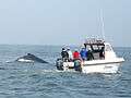 Watching humpback whale in Walvis Bay
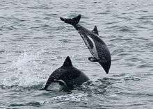 Heaviside's dolphins jumping off Walvis Bay
 Cape fur seals hauling site
.jpg)
References
- ↑ "Table 4.2.2 Urban population by Census years (2001 and 2011)" (PDF). Namibia 2011 – Population and Housing Census Main Report. Namibia Statistics Agency. p. 39. Retrieved 24 August 2016.
- ↑ "Walvis Bay". Ramsar Sites Information Service. Retrieved 25 April 2018.
- ↑ "Local Authorities". Association of Local Authorities in Namibia (ALAN). Retrieved 1 October 2012.
- ↑ "ELECTIONS 2010: Erongo regional profile". New Era. 16 November 2010.
- ↑ Southern Right Whale, Eubalaena australis, The Namibian Dolphin Project
- ↑ Narrative of a voyage to the South Seas Charles Medyett Goodridge, Hamilton and Adams, 1832, page 16
- ↑ The World of Waters or A Peaceful Progress o'er the Unpathed Sea, Fanny Osborne, R. Carter, 1852, page 337
- ↑ Windhoek?! Rather make that Otjomuise Werner Menges, The Namibian, 12 May 2005
- ↑ Foundations of the Portuguese Empire, 1415–1580, Diffie Bailey University of Minnesota Press, 1977, page 156
- ↑ Historical Dictionary of European Imperialism, James Stuart Olson, Robert Shadle, Greenwood Publishing Group, 1991, page 170
- ↑ Às portas da Índia em 1484, Abel Fontoura Costa, Imprensa da Armada, 1935, page 31
- 1 2 Succession of States and Namibian territories, Y. Makonnen in Recueil Des Cours, 1986: Collected Courses of the Hague Academy of International Law, Academie de Droit International de la Haye, Martinus Nijhoff Publishers, 1987, page 213
- ↑ Debates of Parliament, Hansard, Volume 9, Issues 19-21, Government Printer, 1993, page 10179
- 1 2 Walvis Bay: exclave no more, Ieuan Griffiths, Geography, Vol. 79, No. 4 (October 1994), page 354
- ↑ The War in Africa, David Killingray in A Companion to World War I, John Horne, John Wiley & Sons, 2012, page 119
- ↑ Biennial Conference: Papers nos. 33-59, African Studies Association of the UK, 1996, page 5
- ↑ The Namibian War of Independence, 1966-1989: Diplomatic, Economic and Military Campaigns, Richard Dale McFarland, 2014, page 67
- ↑ Strategic territory and territorial strategy: the geopolitics of Walvis Bay's reintegration into Namibia, David Simon, Namibian Economic Policy Research Unit, 1995, page 8
- ↑ Official Documents of the 4th Session of the United Nations General Assembly, United Nations, 1949, page 11
- ↑ The Green and the dry wood: The Roman Catholic Church (Vicariate of Windhoek) and the Namibian socio-political situation, 1971-1981, Oblates of Mary Immaculate, 1983, page 6
- ↑ Sub-Saharan Africa Report, Issues 2578-2584, Foreign Broadcast Information Service., 1982, page 48
- ↑ "Resolution 432 (1978) of 27 July 1978" (PDF). un.org. Retrieved 3 April 2018.
- ↑ Namibia Nears Freedom, But S. Africa Tugs On Its Lifeline, David Zucchino, Philadelphia Inquirer, January 14, 1990
- ↑ Namibia Yearbook, Issue 3, pages 18
- ↑ Country Report: Botswana, Namibia, Swaziland, Lesotho, Economist Intelligence Unit, 1992, page 13
- ↑ Pretoria to quit Walvis Bay: Multi-party body's policy breakthrough, The Independent, 17 August 1993
- ↑ No. 203 of 1993: Transfer of Walvis Bay to Namibia Act, 1993. Archived 23 February 2016 at the Wayback Machine.
- ↑ "Treaty between the Government of the Republic of South Africa and the Government of the Republic of Namibia with respect to Walvis Bay and the off-shore Islands, 28 February 1994" (PDF). un.org. Retrieved 3 April 2018.
- ↑ S.L., Tutiempo Network,. "Climate Walvis Bay, Rooikop - Climate data (681040)". www.tutiempo.net. Retrieved 3 April 2018.
- ↑ "Klimatafel von Pelican Point / Walfisch-Bucht / Namibia" (PDF). Federal Ministry of Transport and Digital Infrastructure. Retrieved 4 November 2016.
- ↑ "STATIONSNUMMER 68104" (PDF). Ministry of Energy, Utilities and Climate. Archived from the original on 16 January 2013. Retrieved 4 November 2016.
- ↑ "Know Your Local Authority". Election Watch (3). Institute for Public Policy Research. 2015. p. 4.
- ↑ "Local elections results". Electoral Commission of Namibia. 28 November 2015. p. 2. Archived from the original on 10 December 2015.
- ↑ "The Speedspot". Vestas Sailrocket. , "Walvis Bay Yacht Club". google maps.
- ↑ The World’s Seven Longest Waves, Surf Europe, 21 July 2015
- ↑ "Sparta Cricket Club Ground". Cricket Archive. Retrieved 6 October 2016.
- ↑ Dall, Nick (6 September 2017). "Is This Country the New Commercial Gateway to Southern Africa?". OZY. Retrieved 2017-09-06.
- 1 2 Larkin, Philippa (24 March 2017). "Walvis Bay aims to become hub for SADC import/export". Business Report. Retrieved 29 July 2018.
- ↑ https://www.newera.com.na/2018/05/14/fishcors-n530-million-factory-ready-by-september/
- ↑ https://www.namibian.com.na/175390/archive-read/N$190m-Peugeot-assembly-plant-for-Nam
- ↑ https://lesstephenson.wordpress.com/2018/03/13/opel-peugeot-to-open-auto-plant-in-remote-walvis-bay/
- ↑ "About us". Namibian Maritime and Fisheries Institute. 2008.
- ↑ Walvis strengthens ties with Drakenstein and Lobatse, Adam Hartman, The Namibian, 8 November 2011
Further reading
- Silverman, Melinda: Between the Atlantic and the Namib. An Environmental History of Walvis Bay, NWG, Windhoek 2004 – Namibiana Buchdepot
- de Beer, Charles: Namibia Marine Life, @tidude Graphix, Swakopmund o.J. – Namibiana Buchdepot
- Heemstra, Phillip; Smith, Margaret M.: Smith's Sea Fishes, Struik Publishers, Cape Town 2003
- Bridgeford, P. and M.: Cape Cross, Walvis Bay 2002 – Namibiana Buchdepot
- Vogt, Andreas: National Monuments in Namibia, Gamsberg Macmillan, Windhoek 2004 – Namibiana Buchdepot
External links
| Wikivoyage has a travel guide for Walvis Bay. |
![]()
- Images from Walvis Bay
- Walvis Bay City Council
- Walvis Bay Airport Information
- Transfer of Walvis Bay To Namibia Act, 1993
- Namibia's Walvis Bay Issue – Origin and Rise of a Colonial Dispute (1992)
- Prime Minister Vorster Speaks on Walvis Bay, Associated Press, 30 July 1978
- Namibia Reclaims Walvis Bay, Associated Press, 28 February 1994