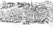
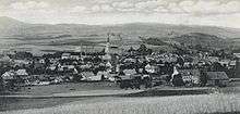
Chrastava
| Chrastava | |||
| Town | |||
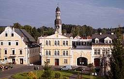 Town Hall | |||
|
|||
| Country | Czech Republic | ||
|---|---|---|---|
| Region | Liberec | ||
| District | Liberec | ||
| Commune | Liberec | ||
| Municipality | Chrastava | ||
| Elevation | 295 m (968 ft) | ||
| Coordinates | 50°49′1″N 14°58′8″E / 50.81694°N 14.96889°ECoordinates: 50°49′1″N 14°58′8″E / 50.81694°N 14.96889°E | ||
| Area | 27.46 km2 (10.60 sq mi) | ||
| Population | 5,976 | ||
| Density | 218/km2 (565/sq mi) | ||
| First mentioned | 1352 | ||
| Mayor | Michael Canov | ||
| Timezone | CET (UTC+1) | ||
| - summer (DST) | CEST (UTC+2) | ||
| Postal code | 463 31 | ||
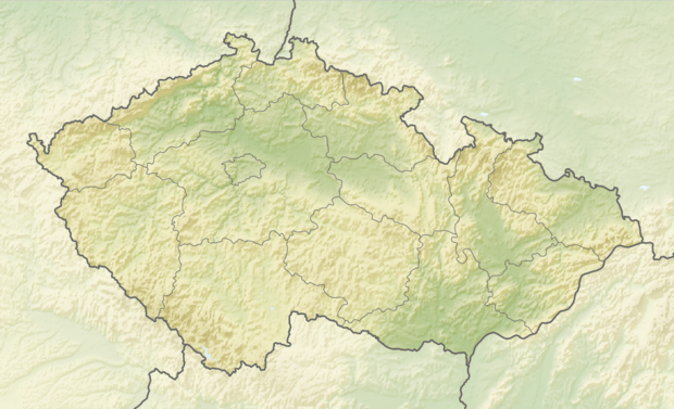 Location in the Czech Republic | |||
| Wikimedia Commons: Chrastava | |||
| Statistics: statnisprava.cz | |||
| Website: www.chrastava.cz | |||
Chrastava (Czech pronunciation: [ˈxrastava]; German: Kratzau) is a town in northern Bohemia in the Czech Republic about 10 kilometre (6 mi) northwest of the regional capital Liberec. The town is situated on the Jeřice brook near to its confluence with the Lusatian Neisse (Czech: Lužická Nisa). Chrastava is surrounded by hills of the Ještěd Mountains and more distant Jizera Mountains.
History
The town of Chrastava was first mentioned in 1351 as Craczauia. It was founded very probably in the end of the 13th century on the site of an older village of the West Slavic Milceni tribe by German settlers, having been invited by King Ottokar II of Bohemia. They came mainly from the city Pirna in Saxony.
Chrastava, then known mostly by the German name Kratzau, was occupied by the Hussites who use the town as a base for expeditions into Lusatia during the Hussite Wars. Kratzau was governed by the Habsburg Monarchy after Bohemia was inherited by the Austrian Habsburgs in 1526. It received town rights in 1527.
The town became a mining centre in 15th and 16th century, in particularly in copper, tin, lead, zinc, iron and silver mining. Two small mining towns, Andělská Hora (German: Engelsberg) and Panenská Hůrka (German: Frauenberg), were established by the miners more closely to the metal veins.
After the mines were abandoned, many of the people were forced to find a new kind of livelihood. Therefore, they started to produce cloth on a loom in many houses in the town. During the 19th century the handicraft industry succumbed to mass production by many textile manufactures that had been built in the town. During the second half of the 19th century Kratzau became famous also for its production of organs and other musical instruments which were exported abroad (e.g. Gebrüder Riemer Kratzau company).
Kratzau became part of Czechoslovakia after the collapse of Austria-Hungary from World War I and was officially renamed Chrastava. The town was almost entirely ethnic German, however, and was ceded to Nazi Germany along with the rest of the Sudetenland after the Munich Agreement in 1938.
In 1943, during World War II, two forced labor camps were set up in the area by Organization Schmelt. These camps provided workers for the Tannwald Textile Works and an ammunition factory (Deutsche Industriewerke AG) that produced hand grenades and other military material for the armed forces of Germany. The camps became subcamps of Gross-Rosen in October 1944. Female prisoners were transported to Kratzau from Auschwitz, as well as from other Gross-Rosen subcamps that were being evacuated. By then the subcamps included Polish, Czech, French, Belgian, Dutch and Danish women.[1]
As more women arrived from the evacuated Gross-Rosen subcamps conditions at Kratzau worsened. Zenon Lis, who was a child at the time, has said the food at Kratzau was "poor and varied at different times: black coffee, dry bread, rutabaga soup, a potato on rare occasions, and a piece of liverwurst on exceptional ones". Joseph Mengele is known to have visited Kratzau three times between October 1944 and March 1945 to conduct a "selection"; after each of these visits the selected women were sent to a subcamp in Zittau.[1]
After the expulsion of Germans after World War II in 1945-1947, Chrastava was resettled mainly by Czechs, along with Slovaks, Roma, and other nationalities.
Demographics
| Year | Population | Czechs (%) | Germans (%) | Other (%) |
|---|---|---|---|---|
| 1737 | 1,061 | - | - | - |
| 1860 | 2,960 | - | - | - |
| 1933 | 4,640 | 15 | 85 | - |
| 1945 | 7,056 | 4 | 75 | 21 |
| 1948 | 2,818 | 86 | 6 | 8 |
| 2001 | 5,944 | 93 | 1 | 6 |
Subdivisions
Chrastava consists of four main town sections and two villages:
- Chrastava I (the central part of the town, German: Kratzau I)
- Chrastava II (German: Kratzau II - Neustadt)
- Chrastava III (so-called Dolní Chrastava, German: Unter-Kratzau)
- Chrastava IV (so-called Horní Chrastava, German: Ober-Kratzau) includes also two hamlets:
- Andělská Hora (German: Engelsberg)
- Vítkov (German: Wittig) consists of two parts:
Natives from Chrastava
- Joseph von Führich (1800–1876), painter
- Wilhelm Kandler (1816–1896), painter
- Theodor Körner (1873–1957), born in Komárno but grew up in Chrastava.[2] The President of Austria from 1951 to 1957.
- Willi Sitte (1921), painter
Sister city
References
- 1 2 Megargee, Geoffrey P. (2009). The United States Holocaust Memorial Museum Encyclopedia of Camps and Ghettos, 1933-1945: pt. A. The early National Socialist concentration camps. Introduction to the early camps. Indiana University Press. pp. 754–756. ISBN 978-0-253-35429-7.
- ↑ "Körner Theodor | Městské Informační Centrum města Hranice". mic.hranet.cz. Retrieved 2016-07-16.
External links
| Wikimedia Commons has media related to Chrastava. |
- virtual show
- Municipal website (in Czech)
| Authority control |
|---|