Puducherry
| Puducherry Pondichéry | ||
|---|---|---|
| Union territory of India | ||
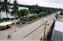
 Aerial view of Pondicherry | ||
| ||
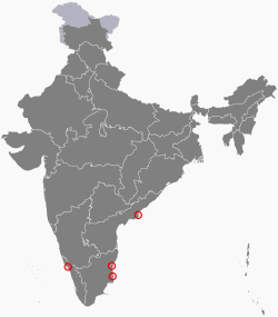 Location of Puducherry (marked in red) in India | ||
| Coordinates: 11°54′40″N 79°48′45″E / 11.911082°N 79.812533°ECoordinates: 11°54′40″N 79°48′45″E / 11.911082°N 79.812533°E | ||
| Country |
| |
| French India colony of the French colonial empire | 1673 | |
| de facto transfer to India | 1 November 1954 | |
| de jure transfer to India | 16 August 1962 | |
| Capital and Largest city | Pondicherry | |
| Districts | 4 | |
| Government | ||
| • Lieutenant Governor | Kiran Bedi[1] | |
| • Chief Minister | V. Narayanasamy (INC) [2] | |
| • Chief Secretary | Ashwani Kumar, IAS[3] | |
| • Director General of Police | Sunil Kumar Gautam, IPS[4] | |
| • Legislature | Unicameral (33*seats) [5] | |
| Area | ||
| • Total | 562 km2 (217 sq mi) | |
| Area rank | 33rd | |
| Population (2011) | ||
| • Total | 1,244,464 | |
| • Rank | 29th | |
| • Density | 2,200/km2 (5,700/sq mi) | |
| Demonym(s) | Puducherrian | |
| Languages | ||
| • Official | Tamil (in Pondicherry and Karaikal) [6] Malayalam (in Mahé), Telugu (in Yanam), English[6] and French | |
| Time zone | UTC+05:30 (IST) | |
| ISO 3166 code | IN-PY | |
| Vehicle registration | PY 01, PY 02, PY 03, PY 04, PY 05, PY 05V | |
| Website | www.py.gov.in | |
| ^* 30 elected, 3 nominated | ||
Puducherry (/pʊdʊˈtʃɛri/, literally New Town in Tamil),[7] formerly known as Pondicherry (/pɒndɪˈtʃɛri/; French: Pondichéry), is a union territory of India. It was formed out of four exclaves of former French India, namely Pondichéry (Pondicherry; now Puducherry), Karikal (Karaikal), Mahé and Yanaon (Yanam). It is named after the largest district, Puducherry. Historically known as Pondicherry (Pāṇṭiccēri), the territory changed its official name to Puducherry (Putuccēri) on 20 September 2006.[8]
Puducherry lies in the southern part of the Indian Peninsula. The areas of Puducherry district and Karaikal district are bound by the state of Tamil Nadu, while Yanam district and Mahé district are enclosed by the states of Andhra Pradesh and Kerala respectively. Puducherry is the 29th most populous and the third most densely populated of the states and union territories of India. It has a gross domestic product (GDP) of ₹0.21 lakh crore (US$2.9 billion) and ranks 27th in India.[9]
History
The earliest recorded history of Puducherry can be traced to the 2nd century AD. The Periplus of the Erythraean Sea mentions a marketplace named Poduke (ch 60). G. W. B. Huntingford suggested this might be a site about 2 miles from the modern Puducherry, which was possibly the location of Arikamedu (now part of Ariyankuppam). Huntingford noted that Roman pottery was found at Arikamedu in 1937. In addition, archaeological excavations between 1944 and 1949 showed that it was "a trading station to which goods of Roman manufacture were imported during the first half of the 1st century CE" Subsequent investigation by Vimala Begley from 1989 to 1992 modified this assessment, and now place the period of occupation from the 3rd or 2nd century BCE to the 8th century CE.[10] to .[11]
In 1674, Pondicherry (Pondichéry) became a French colony of the French colonial empire. Together with Chandernagor (already French since 1673), Mahé (since 1721), Yanam (Yanaon) (since 1731), Karaikal (Karikal) (since 1739) and Masulipatam (1760), it formed the French colony of French India, under a single French governor in Pondicherry, although French rule over one or more of these enclaves was repeatedly interrupted by British occupations. The territories of French India were completely transferred to the Republic of India de facto on 1 November 1954, and de jure on 16 August 1962, when French India ceased to exist, becoming the present Indian constituent union territory of Pondicherry, still combining four coastal enclaves.
Geography
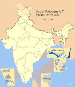
The union territory of Puducherry consists of four small unconnected districts: Puducherry district (393 km2 (152 sq mi)), Karaikal district (160 km2 (62 sq mi)) and Yanam district (30 km2 (12 sq mi)) on the Bay of Bengal and Mahé district (9 km2 (3.5 sq mi)) on the Arabian Sea, covering a total area of 592 km2 (229 sq mi). Puducherry and Karaikal have the largest areas and population, and are both enclaves of Tamil Nadu. Yanam and Mahé are enclaves of Andhra Pradesh and Kerala, respectively. Its population, as per the 2011 Census, is 1,244,464.
Some of Puducherry's regions are themselves amalgamations of non-contiguous enclaves, often called pockets in India. The Puducherry region is made of 11 such pockets, some of which are very small and entirely surrounded by the territory of Tamil Nadu. Mahé region is made up of three pockets. This unusual geography is a legacy of the colonial period with Puducherry retaining the borders of former French India.
All four regions of Puducherry are located in the coastal region. Five rivers in Puducherry district, seven in Karaikal district, two in Mahé district and one in Yanam district drain into the sea, but none originates within the territory.
Districts of Union Territory of Puducherry
- Puducherry district is an enclave of Tamil Nadu.
- Mahé district is an enclave of Kerala.
- Yanam district is an enclave of Andhra Pradesh.
- Karaikkal district is an enclave of Tamil Nadu.
Demographics
Hinduism is the major religion with 87.3% of the population adhering to it. Other religions include Christianity (6.2%) and Islam (6%).[12]
Government and administration
Puducherry is a Union Territory of India rather than a state, which implies that governance and administration falls directly under federal authority. However, Puducherry is one of only two union territories in India (the other being Delhi), that is entitled by a special constitutional amendment to have an elected legislative assembly and a cabinet of ministers, thereby conveying partial statehood.[13]
The Centre is represented by the Lieutenant Governor, who resides at the Raj Nivas (Le Palais du Gouverneur) at the Park, the former palace of the French governor. The central government is more directly involved in the territory's financial well-being unlike states, which have a central grant that they administer. Consequently, Puducherry has at various times, enjoyed lower taxes, especially in the indirect category.
Special administration status
According to the Treaty of Cession of 1956, the four territories of former French India territorial administration are permitted to make laws with respect to specific matters. In many cases, such legislation may require ratification from the federal government or the assent of the President of India.
Article II of the Treaty states:
“The Establishments will keep the benefit of the special administrative status which was in force prior to 1 November 1954. Any constitutional changes in this status which may be made subsequently shall be made after ascertaining the wishes of the people.”
Official languages
French was the official language according to Article XXVIII of the "Traité de Cession" (Treaty of Cession) of 1956. According to the treaty, "the French language shall remain the official language of the Establishments so long as the elected representatives of the people shall not decide otherwise". Through the 1963 Union Territories Act, Tamil, Telugu, Marathi and Malayalam became official languages used region-wise.[14][15] French did not lose its official status even after the adoption of The Pondicherry Official Language Act 1965 (Act No. 3 of 1965).[16] This act stated that "the Tamil language shall (...) be the language to be used for all or any of the official purposes of the Union territory". It also provides for the use of the Malayalam and Telugu languages in the Mahé and Yanam districts. The law also states that English "may be used for all or any of the official purposes of the Union territory".[17] As of today, the official gazette of Puducherry is still published in French, albeit with a marginal use.[18]
Official symbols
On 16 April 2007, the government of Puducherry announced that the following were to be its state symbols:[19]
| Song | Invocation to Tamil Goddess (written by Bharathidasan) |
|---|---|
| Animal | Squirrel |
| Bird | Koel |
| Flower | Cannonball tree's flower |
| Tree | Bael fruit tree |
Culture
French influence

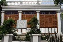
The plan of the city of Pondicherry is based on the French grid pattern and features perpendicular streets. The town is divided into two sections: the French Quarter (Ville Blanche or 'White Town') and the Indian quarter (Ville Noire or 'Black Town'). Many streets retain French names, and villas in French architectural styles are a common sight. In the French quarter, the buildings are typically in French colonial style, with long compounds and stately walls. The Indian quarter consists of houses lined with verandas and with large doors and grilles. These French- and Indian-style houses are preserved from destruction by an organisation named INTACH. The French language can be seen on signs and menus, and heard in Puducherry. Puducherry has residents with French passports: Most are of Indian descent and a small number are of non-Indian descent. At the time of Puducherry's transfer to India in 1954, residents were given a choice to retain their French citizenship or to gain Indian citizenship. Those with French passports today are generally descendants of residents who chose to keep their French citizenship.
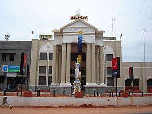
Several monuments in the city pertain to the French period. A French Consulate is in Puducherry, along with cultural organisations. Another important building is Le Foyer du Soldat, a veterans legion hall for soldiers who served in French wars. Among the French cultural organisations, the French Institute of Pondicherry, the Puducherry Centre of the École française d'Extrême-Orient and a branch of the Alliance Française are noteworthy. A French high school (Lycée français de Pondichéry) operates under the aegis of the French Minister of National Education.
Economy
The gross state domestic product of Puducherry, at market prices estimated by Ministry of Statistics and Programme Implementation with figures in crores of Indian rupees grew from 184 to 25,819 crore rupees from 1980– 2014.
| Year | Gross State Domestic Product |
|---|---|
| 1980 | 184 |
| 1985 | 342 |
| 1990 | 603 |
| 1995 | 1,320 |
| 2000 | 3,781 |
| 2010 | 13,092 |
| 2014 | 25,819 [20] |
Fisheries
The potential for fisheries is substantial in the Union Territory. The four regions of the Union Territory have a coastline of 45 km with 675 of inshore waters, 1.347 hectares (3.33 acres) of inland water and 800 ha of brackish water. 27 marine fishing villages and 23 inland fishing villages host a fishermen population of about 65,000 of which 13,000 are actively engaged in fishing. Tanks and ponds are also tapped for commercial fish rearing.
Tourism
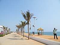
Puducherry is one of the most popular tourist spots for national and international tourists. Out of 274 Paadal Petra Sthalam Shiva Temples, the Puducherry region is owning 1 temple and in Karaikal regions it is having 4 temples which itself a clear proof that the Puducherry territory is also a part of the spiritual and sacramental of Shaivism principles. Besides in Villianur, Bahour and in so many areas of Puducherry region there are so many Shiva temples built up during the golden period of King Chola empire which gives immense pleasure to be proud of that our Puducherry territory was administered under the control of such golden rulers. So visiting such ancient temples would definitely give more spiritual vibrations to the tourists. For every year the Puducherry territory administration also declares official Holiday for performing the grand Car Festivals to the temples situates in Villianur, Veerampattinam that too the Lieutenant Governor of Puducherry and the Chief Minister of Puducherry also participates in such grand Car Festival. Besides in Kizhoor, Puducherry which is 22 km away from Puducherry therein on 18-10-1954 a referendum was conducted to ensure that whether the erstwhile French establishments of Puducherry shall continue with French administration or to merge with Indian Union and finally decided to merge with Indian Union. Puducherry was the residence of Sri Aurobindo (1872–1950) and the Sri Aurobindo Ashram still operates from Puducherry. A unique experimental city Auroville, the brainchild of the Mother, whose inhabitants are drawn from all parts of the world is situated on the outskirts of the city. There are several temples, churches, monuments, parks and mosques which attract tourists.

Transport
Rail
Puducherry is connected by a railway branch line from the five-way junction at Viluppuram and Chennai. The railway line is a broad gauge line with 16 originating Trains and 17 Terminating Trains[21]
Road
Puducherry has a network all weather metalled roads connecting the territory. Puducherry has a road length of 2,552 km (road length per 4.87 km2), the highest in the country.
| Road length comparison with Tamil Nadu and India as a whole | |||
|---|---|---|---|
| Total road length (in Puducherry) | 2,552 km | ||
| Road length per 1000 km2 | Puducherry | Tamil Nadu | India |
| 4,575 | 1,572 | 663 | |
| Sl. No. | Type of road | Length in (km) |
|---|---|---|
| 1 | National highways | 64.450 |
| 2 | State highways | 49.304 |
| 3 | District & other roads | |
| Puducherry – 173.384 | ||
| Karaikal – 55.162 | ||
| Mahé – 19.622 | ||
| Yanam – 26.460 | ||
| 274.628 | 274.628 | |
| 4 | Rural roads | |
| Puducherry – 164.964 | ||
| Karaikal – 83.470 | ||
| 248.434 | 248.434 | |
| Grand total | 636.816 |
Air
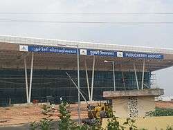
Puducherry Airport is situated at Lawspet. The Puducherry Government upgraded the airport in 2012[22] with a new terminal building and apron to accommodate larger aircraft. The new terminal building was inaugurated in January 2013 and scheduled flights to Bengaluru were launched.[23] A MoU has been signed with Airports Authority of India for expansion of Puducherry Airport in two phases.[24] Karaikal Airport is a planned greenfield airport and will be the India's first airport to be built entirely with private capital.[25]
Education
Puducherry has a literacy rate of 86.55%.[26] Pondicherry University is a central university located in Puducherry.[27] Other colleges include Jawaharlal Institute of Postgraduate Medical Education & Research (JIPMER), Indira Gandhi Medical College and Research Institute (Government of Puducherry), Indira Gandhi College of Arts and science (Govt of Puducherry), Mahatma Gandhi Medical College and Research Institute, National Institute of Technology, Puducherry, Perunthalaivar Kamarajar Institute of Engineering and Technology,[28] Pondicherry Engineering College, Mother Theresa Post Graduate and Research Institute of Health Sciences, Achariya College of Engineering & Technology ACET,Rajiv Gandhi College of Engineering and Technology, Rajiv Gandhi College of Veterinary and Animal Sciences, Christ institute of technology, Sri Manakula Vinayagar Engineering College, Shri Krishnaa College of Engineering & Technology, Sri Ganesh College Of Engineering and Technology and Sri Venkateshwaraa Medical College Hospital and Research Centre.
In Popular culture
- Puducherry was the setting for Yann Martel's first third of his Booker Prize-winning novel Life of Pi (2001). A portion of the subsequent film adaptation of the same name was filmed there.[29]
- Lee Langley's novel A House in Pondicherry (1996) was set there.
- Prince Pondicherry is an Indian character from Roald Dahl's children's novel Charlie and the Chocolate Factory (1964). The prince orders Willy Wonka to build a palace of chocolate in India; the palace melts in the hot sun.
- The 9th season of the reality show Splisvilla on MTV was set in Puducherry.
See also
References
- ↑ "narendra modi appointe Lieutenant Governor of Puducherry". The Hindu. 22 May 2016. Retrieved 25 May 2016.
- ↑ "V Narayanasamy to be new Puducherry Chief Minister".
- ↑ Varma, M. Dinesh (2015-06-06). "New Chief Secretary assumes charge". The Hindu. ISSN 0971-751X. Retrieved 2016-11-09.
- ↑ "IG Sunil Kumar Gautam to assume charge after polls". The Hindu. 2016-02-18. ISSN 0971-751X. Retrieved 2016-11-09.
- ↑ "PUDUCHERRY LEGISLATIVE ASSEMBLY".
- 1 2 "Report of the Commissioner for Linguistic Minorities in India: 50th report (delivered to the Lokh Sabha in 2014)" (PDF). National Commissioner for Linguistic Minorities, Ministry of Minority Affairs, Government of India. p. 155. Archived from the original (PDF) on 8 July 2016. Retrieved 29 June 2016.
- ↑ "South Asia | New name for old French territory". BBC News. 20 September 2006. Retrieved 10 February 2014.
- ↑ "National : Bill to rename Pondicherry as Puducherry passed". The Hindu. 22 August 2006. Retrieved 10 February 2014.
- ↑ "State Domestic Product and other aggregates, 2004–05 series". Ministry of Statistics and Programme Implementation. 27 February 2015. Archived from the original on 23 March 2015. Retrieved 18 June 2015.
- ↑ The Dating of Arikamedu and its Bearing on the Archaeology of Early ... utilisateurs.linguist.univ-paris-diderot.fr/~chevilla/FestSchrift/V_Beg_3x.pdf
- ↑ The Periplus of the Erythraean Sea: Travel and Trade in the Indian Ocean by a Merchant of the First Century. Kessinger Publishing. July 2007. p. 119. ISBN 978-0-548-20943-1.
- ↑ "Population by religion community – 2011". Census of India, 2011. The Registrar General & Census Commissioner, India. Archived from the original on 25 August 2015.
- ↑ "Lanka BBC Info Know Puducherry: Government Name Pondicherry As Puducherry". lankabbc.com. 2012-06-29. Retrieved 2017-01-24.
- ↑ "The Government of Union Territories Act, 1963" (PDF). Ministry of Home Affairs, Government of India. Retrieved 1 June 2015.
- ↑ "Puducherry code volume 1" (pdf). Government of Puducherry. Retrieved 1 June 2015.
- ↑ "Archived copy". Archived from the original on 2 April 2015. Retrieved 12 June 2015.
- ↑ CIDIF. "06-Le français à Pondichéry, par Roland Breton". go1.cc. Archived from the original on 9 April 2015.
- ↑ "Archived copy" (PDF). Archived from the original (PDF) on 11 October 2017. Retrieved 11 October 2017.
- ↑ "Tamil Nadu News : Puducherry comes out with list of State symbols". The Hindu. 21 April 2007. Retrieved 10 February 2014.
- ↑ List of Indian states by GDP
- ↑ karthik. "Pondicherry Station - 16 Train Departures SR/Southern Zone - Railway Enquiry". indiarailinfo.com.
- ↑ "Flight operations await new terminal". IBN Live. 10 May 2012. Retrieved 3 July 2012.
- ↑ "First flight to Puducherry from Bangalore on January 17". Retrieved 5 February 2013.
- ↑ "Puducherry airport to go on stream in October". The Economic Times. 3 September 2011. Retrieved 3 January 2012.
- ↑ "Coimbatore firm to build India's first private airport in Karaikal". The Times of India. 13 March 2012. Retrieved 3 July 2012.
- ↑ "Ranking of states and union territories by literacy rate: 2011" (PDF). Government of India.
- ↑ "Pondicherry University". Pondicherry University. Archived from the original on 25 April 2011.
- ↑ "Welcome to the Website of PKIET". Pkiet.edu.in. Retrieved 10 February 2014.
- ↑ "Filming Locations". Internet Movie Database. Retrieved 3 December 2012.
External links
| Wikivoyage has a travel guide for Pondicherry (union territory). |
| Wikimedia Commons has media related to Puducherry. |
| Wikiquote has quotations related to: Puducherry |
- Official website of the Government of the Union Territory of Puducherry
- Treaty establishing De Jure Cession of French Establishments in India
- Official website of Department of Tourism, Pondicherry
- Official website of Puducherry Tourism, by Pondy Tourism
- Events and happenings in and around Puducherry

| Authority control |
|---|