Veľký Krtíš
| Veľký Krtíš | ||
| Town | ||
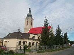 Lutheran church and rectory | ||
|
||
| Country | Slovakia | |
|---|---|---|
| Region | Banská Bystrica | |
| District | Veľký Krtíš | |
| River | Krtíš | |
| Elevation | 200 m (656 ft) | |
| Coordinates | 48°12′54″N 19°20′17″E / 48.21500°N 19.33806°ECoordinates: 48°12′54″N 19°20′17″E / 48.21500°N 19.33806°E | |
| Area | 15.028 km2 (6 sq mi) | |
| Population | 11,657 (2017-05-01) | |
| Density | 776/km2 (2,010/sq mi) | |
| First mentioned | 1245 | |
| Mayor | Dalibor Surkoš | |
| Timezone | CET (UTC+1) | |
| - summer (DST) | CEST (UTC+2) | |
| Postal code | 990 01 | |
| Phone prefix | 421-47 | |
| Car plate | VK | |
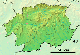 Location of Veľký Krtíš in the Banská Bystrica Region  Veľký Krtíš (Slovakia) | ||
| Statistics: MOŠ/MIS | ||
| Website: http://www.velky-krtis.sk | ||
Veľký Krtíš (before 1927 Veľký Krtýš, Hungarian: Nagykürtös) is a town in southern Slovakia, situated in the historical Novohrad region. The town's most important economic sectors are mining and agriculture.
Etymology
The name is of Hungarian origin and is probably derived from the word kürtös (a bugler) or motivated by the ethnonym Kürt (one of Magyar tribes).[1]
History
The town was first mentioned in the second half of the 13th century, although the name Krtíš first appeared in 1245 under name Curtus (Latin). Until 1919 it was the part of the Hungarian Kingdom, later Austria-Hungary, part of the Nograd - Novohrad region. It was ruled by Ottoman Empire between 1554 and 1594 and again between 1596 and 1686 as part of Filek sanjak, its centre was Rim Sonbat. After Treaty of Trianon it became part of Czechoslovakia. In the Second World War, the village remained in the Slovak state, a Nazi-Germany ally. The village suffered demages in the spring of 1945 when the Soviet army of the 2nd Ukrainian front together with the Romanian army met the Nazi Germany units. A Romanian military cemetery can be found in the nearby Modry Kamen. The village developed to a town in the 1960's with the opening of the mine for brown coal.
Geography
Veľký Krtíš lies at an altitude of 200 metres (656 ft) above sea level and covers an area of 15.028 square kilometres (5.8 sq mi).[2] It is situated in the Krupinská planina, at the foothills of Javorie, around 15 kilometres (9 mi) north of the Hungarian border and around 75 kilometres (47 mi) south of Banská Bystrica.
Demographics
In May 2017 the town had 11,657 inhabitants.[3] According to the 2011 census 86.93% of inhabitants were Slovaks, 6.20% Hungarians, 2.06% Roma and 0.78% Czechs.[2] The religious make-up was 54.26% Roman Catholics, 21.58% people with no religious affiliation and 16.00% Lutherans.[2]
References
- ↑ Krajčovič, Rudolf (2005). Živé kroniky miest a obcí [Living Chronicles of Towns and Villages] (in Slovak). Bratislava: Literárne a informačné centrum. p. 126. ISBN 80-88878-99-3.
- 1 2 3 "Municipal Statistics". Statistical Office of the Slovak republic. Archived from the original on January 11, 2008. Retrieved 2008-01-31.
- ↑ http://www.velky-krtis.sk/zakladne-informacie.phtml?id3=12027