Chester, Massachusetts
| Chester, Massachusetts | ||
|---|---|---|
| Town | ||
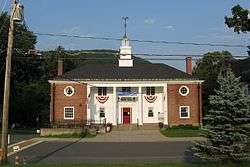 Town Hall | ||
| ||
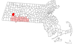 Location in Hampden County in Massachusetts | ||
| Coordinates: 42°16′45″N 72°58′45″W / 42.27917°N 72.97917°WCoordinates: 42°16′45″N 72°58′45″W / 42.27917°N 72.97917°W | ||
| Country | United States | |
| State | Massachusetts | |
| County | Hampden | |
| Settled | 1760 | |
| Incorporated | 1783 | |
| Government | ||
| • Type | Open town meeting | |
| Area | ||
| • Total | 37.2 sq mi (96.3 km2) | |
| • Land | 36.6 sq mi (94.8 km2) | |
| • Water | 0.6 sq mi (1.5 km2) | |
| Elevation | 601 ft (183 m) | |
| Population (2010) | ||
| • Total | 1,337 | |
| • Density | 37/sq mi (14.1/km2) | |
| Time zone | UTC-5 (Eastern) | |
| • Summer (DST) | UTC-4 (Eastern) | |
| ZIP code | 01011 | |
| Area code(s) | 413 | |
| FIPS code | 25-13485 | |
| GNIS feature ID | 0619385 | |
| Website |
townofchester | |

Chester is a town in Hampden County, Massachusetts, United States, situated in the western part of the state. It is part of the Springfield, Massachusetts metropolitan statistical area. The town includes the Chester Factory Village Historic District. The total population was 1,337 in the 2010 census.[1]
History
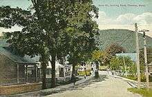
.jpg)
The area opened for settlement in the 1750s as Township No. 9, chartered as Murrayfield on October 31, 1765. The town was incorporated as Chester on February 21, 1783. The Western Railroad (later Boston & Albany Railroad) opened to Chester on May 24, 1841.[2]
Geography
Set on the eastern edge of the Berkshires, Chester makes up the northwest corner of Hampden County. It is bordered by Huntington on the east, Worthington and Middlefield on the north, Becket on the west, and Blandford on the south. Chester is 21 miles (34 km) southeast of Pittsfield, 30 miles (48 km) northwest of Springfield, 115 miles (185 km) west of Boston, 60 miles (97 km) southeast of Albany, New York, and 150 miles (240 km) northeast of New York City.
According to the United States Census Bureau, the town has a total area of 37.2 square miles (96.3 km2), of which 36.6 square miles (94.8 km2) are land and 0.58 square miles (1.5 km2), or 1.56%, are water.[1] It is drained by tributaries of the Westfield River. The West Branch of the Westfield flows through the western and southern parts of town and passes through the village of Chester, while the Middle Branch flows through the northern and eastern parts of the town, passing through the villages of North Chester and Dayville. The small village of Chester Center occupies high ground between the two river branches. U.S. Route 20 follows the West Branch from the southeast corner of the town to Chester village, then turns west up the valley of Walker Brook on its way to the town of Becket.
Temperature records
On August 2, 1975, the temperature in Chester rose to 107 °F (42 °C). This remains the hottest temperature ever recorded in the state of Massachusetts, along with a similar reading in New Bedford on the same day. On January 12, 1981, the temperature at Chester fell to −35 °F (−37 °C), the coldest temperature ever recorded in Massachusetts. Thus, Chester is only one of three places in the United States which has recorded both of its state's extreme temperatures, the others being Millsboro, Delaware, and Warsaw, Missouri.[3][4]
Demographics
| Historical population | ||
|---|---|---|
| Year | Pop. | ±% |
| 1850 | 1,521 | — |
| 1860 | 1,314 | −13.6% |
| 1870 | 1,253 | −4.6% |
| 1880 | 1,473 | +17.6% |
| 1890 | 1,295 | −12.1% |
| 1900 | 1,450 | +12.0% |
| 1910 | 1,377 | −5.0% |
| 1920 | 1,302 | −5.4% |
| 1930 | 1,464 | +12.4% |
| 1940 | 1,284 | −12.3% |
| 1950 | 1,292 | +0.6% |
| 1960 | 1,155 | −10.6% |
| 1970 | 1,025 | −11.3% |
| 1980 | 1,123 | +9.6% |
| 1990 | 1,280 | +14.0% |
| 2000 | 1,308 | +2.2% |
| 2010 | 1,337 | +2.2% |
Source: United States Census records and Population Estimates Program data.[5][6][7][8][9][10][11][12][13][14] | ||

As of the census[15] of 2000, there were 1,308 people, 500 households, and 360 families residing in the town. The population density was 35.6 people per square mile (13.7/km²). There were 580 housing units at an average density of 15.8 per square mile (6.1/km²). The racial makeup of the town was 98.24% White, 0.15% African American, 0.46% Native American, 0.08% Asian, 0.31% from other races, and 0.76% from two or more races. Hispanic or Latino of any race were 1.30% of the population.
There were 500 households out of which 35.0% had children under the age of 18 living with them, 60.0% were married couples living together, 7.6% had a female householder with no husband present, and 27.8% were non-families. 21.2% of all households were made up of individuals and 8.6% had someone living alone who was 65 years of age or older. The average household size was 2.62 and the average family size was 3.06.
In the town, the population was spread out with 25.0% under the age of 18, 7.3% from 18 to 24, 30.2% from 25 to 44, 26.1% from 45 to 64, and 11.5% who were 65 years of age or older. The median age was 39 years. For every 100 females, there were 106.0 males. For every 100 females age 18 and over, there were 102.3 males.
The median income for a household in the town was $43,816, and the median income for a family was $51,932. Males had a median income of $38,083 versus $25,789 for females. The per capita income for the town was $18,098. About 2.9% of families and 5.8% of the population were below the poverty line, including 3.0% of those under age 18 and 7.8% of those age 65 or over.
Library
The Chester public library was established in 1894.[16][17] In fiscal year 2008, the town of Chester spent 1.04% ($28,512) of its budget on its public library—some $22 per person.[18]
Theater
Chester is home to Chester Theatre Company, a professional summer theater founded in 1990.[19]
Notable people
- Rowland Day, congressman
- Capt. David Shepard, American doctor and soldier; an early proponent of inoculation to prevent smallpox
- The Reverend Reuben Tinker, missionary in Hawaii, born in 1799
- Mary Throop Wood Tinker, missionary in Hawaii, born in 1809
See also
References
- 1 2 "Geographic Identifiers: 2010 Census Summary File 1 (G001): Chester town, Hampden County, Massachusetts". American Factfinder. U.S. Census Bureau. Retrieved August 3, 2017.
- ↑ Exploring Western Massachusetts -- History of Chester
- ↑ "Record Highest Temperatures by State" (PDF). National Climatic Data Center. Retrieved June 20, 2013.
- ↑ "Record Lowest Temperatures by State" (PDF). National Climatic Data Center. Retrieved June 20, 2013.
- ↑ "Total Population (P1), 2010 Census Summary File 1". American FactFinder, All County Subdivisions within Massachusetts. United States Census Bureau. 2010.
- ↑ "Massachusetts by Place and County Subdivision - GCT-T1. Population Estimates". United States Census Bureau. Retrieved July 12, 2011.
- ↑ "1990 Census of Population, General Population Characteristics: Massachusetts" (PDF). US Census Bureau. December 1990. Table 76: General Characteristics of Persons, Households, and Families: 1990. 1990 CP-1-23. Retrieved July 12, 2011.
- ↑ "1980 Census of the Population, Number of Inhabitants: Massachusetts" (PDF). US Census Bureau. December 1981. Table 4. Populations of County Subdivisions: 1960 to 1980. PC80-1-A23. Retrieved July 12, 2011.
- ↑ "1950 Census of Population" (PDF). Bureau of the Census. 1952. Section 6, Pages 21-10 and 21-11, Massachusetts Table 6. Population of Counties by Minor Civil Divisions: 1930 to 1950. Retrieved July 12, 2011.
- ↑ "1920 Census of Population" (PDF). Bureau of the Census. Number of Inhabitants, by Counties and Minor Civil Divisions. Pages 21-5 through 21-7. Massachusetts Table 2. Population of Counties by Minor Civil Divisions: 1920, 1910, and 1920. Retrieved July 12, 2011.
- ↑ "1890 Census of the Population" (PDF). Department of the Interior, Census Office. Pages 179 through 182. Massachusetts Table 5. Population of States and Territories by Minor Civil Divisions: 1880 and 1890. Retrieved July 12, 2011.
- ↑ "1870 Census of the Population" (PDF). Department of the Interior, Census Office. 1872. Pages 217 through 220. Table IX. Population of Minor Civil Divisions, &c. Massachusetts. Retrieved July 12, 2011.
- ↑ "1860 Census" (PDF). Department of the Interior, Census Office. 1864. Pages 220 through 226. State of Massachusetts Table No. 3. Populations of Cities, Towns, &c. Retrieved July 12, 2011.
- ↑ "1850 Census" (PDF). Department of the Interior, Census Office. 1854. Pages 338 through 393. Populations of Cities, Towns, &c. Retrieved July 12, 2011.
- ↑ "American FactFinder". United States Census Bureau. Archived from the original on 2013-09-11. Retrieved 2008-01-31.
- ↑ Report of the Free Public Library Commission of Massachusetts. v.9 (1899)
- ↑ "Archived copy". Archived from the original on 2010-10-27. Retrieved 2010-11-09. Retrieved 2010-11-09
- ↑ July 1, 2007, through June 30, 2008; cf. The FY2008 Municipal Pie: What’s Your Share? Commonwealth of Massachusetts, Board of Library Commissioners. Boston: 2009. Available: Municipal Pie Reports Archived 2012-01-23 at the Wayback Machine.. Retrieved 2010-08-04
- ↑ "Vincent Dowling, 83; Irish actor, director cofounded Chester Theatre Company". The Boston Globe. Retrieved May 30, 2017.
- Chester Folks: The Founders of the Town, Their Ancestors and Descendants. Compiled by William S. Mills, 1923; Edited by Charles B. Moore, 1996. Available from the Chester Historical Society
- Chester, MA by Narrative compiled by the Massachusetts Department of Housing and Community Development (DHCD), at MassOnline
External links
| Wikimedia Commons has media related to Chester, Massachusetts. |
- Town of Chester official website
- Hamilton Memorial Library
- Chester Historical Society
- Chester Railway Station & Museum
- Chester Theatre Company
- Gateway Regional High School
- MHC Survey Reconnaissance Town Report: Chester, Massachusetts Historical Commission, 1982
Municipalities and communities of Hampden County, Massachusetts, United States | ||
|---|---|---|
| Cities | 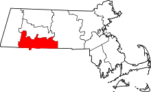 | |
| Towns | ||
| CDPs | ||
| Other villages | ||
| Footnotes | ‡This populated place also has portions in an adjacent county or counties | |