Franklin County, Pennsylvania
| Franklin County, Pennsylvania | ||
|---|---|---|
| County | ||
| Franklin County | ||
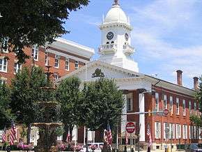
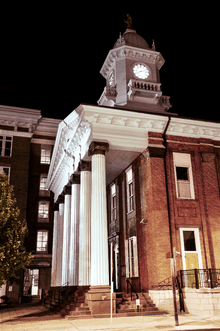 Franklin County Courthouse | ||
| ||
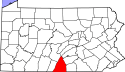 Location in the U.S. state of Pennsylvania | ||
 Pennsylvania's location in the U.S. | ||
| Founded | September 9, 1784 | |
| Named for | Benjamin Franklin | |
| Seat | Chambersburg | |
| Largest borough | Chambersburg | |
| Area | ||
| • Total | 773 sq mi (2,002 km2) | |
| • Land | 772 sq mi (1,999 km2) | |
| • Water | 0.6 sq mi (2 km2), 0.08% | |
| Population (est.) | ||
| • (2017) | 154,234 | |
| • Density | 200/sq mi (80/km2) | |
| Congressional district | 9th | |
| Time zone | Eastern: UTC−5/−4 | |
| Website |
www | |

Franklin County is a county located in South Central Pennsylvania. As of the 2010 census, the population was 149,618.[1] Its county seat is Chambersburg.[2]
Franklin County comprises the Chambersburg–Waynesboro, PA Metropolitan Statistical Area, which is also included in the Washington–Baltimore–Arlington, DC–MD–VA–WV–PA, Combined Statistical Area. It lies to a large extent within the Cumberland Valley.
History
Originally part of Lancaster County (1729), then York County (1749), then Cumberland County (1750), Franklin County became an independent jurisdiction on September 9, 1784, relatively soon after the end of the American Revolutionary War.[3] It is named in honor of Founding Father Benjamin Franklin.[4]
Geography
According to the U.S. Census Bureau, the county has a total area of 773 square miles (2,000 km2), of which 772 square miles (2,000 km2) is land and 0.6 square miles (1.6 km2) (0.08%) is water.[5]
Franklin County is in the watershed of the Chesapeake Bay and the overwhelming majority of it is drained by the Potomac River, but the Conodoguinet Creek and the Sherman Creek drain northeastern portions into the Susquehanna River. It has a hot-summer humid continental climate (Dfa) and its hardiness zone is 6b.
Adjacent counties
- Juniata County (north)
- Perry County (northeast)
- Cumberland County (northeast)
- Huntingdon County (Northwest)
- Adams County (east)
- Frederick County, Maryland (southeast)
- Washington County, Maryland (south)
- Fulton County (west)
Major Highways
Demographics
| Historical population | |||
|---|---|---|---|
| Census | Pop. | %± | |
| 1790 | 15,662 | — | |
| 1800 | 19,638 | 25.4% | |
| 1810 | 23,083 | 17.5% | |
| 1820 | 31,892 | 38.2% | |
| 1830 | 35,037 | 9.9% | |
| 1840 | 37,793 | 7.9% | |
| 1850 | 39,904 | 5.6% | |
| 1860 | 42,126 | 5.6% | |
| 1870 | 45,365 | 7.7% | |
| 1880 | 49,855 | 9.9% | |
| 1890 | 51,433 | 3.2% | |
| 1900 | 54,902 | 6.7% | |
| 1910 | 59,775 | 8.9% | |
| 1920 | 62,275 | 4.2% | |
| 1930 | 65,010 | 4.4% | |
| 1940 | 69,378 | 6.7% | |
| 1950 | 75,927 | 9.4% | |
| 1960 | 88,172 | 16.1% | |
| 1970 | 100,833 | 14.4% | |
| 1980 | 113,629 | 12.7% | |
| 1990 | 121,082 | 6.6% | |
| 2000 | 129,308 | 6.8% | |
| 2010 | 149,618 | 15.7% | |
| Est. 2017 | 154,234 | [6] | 3.1% |
| U.S. Decennial Census[7] 1790–1960[8] 1900–1990[9] 1990–2000[10] | |||
As of the census[11] of 2000, there were 129,313 people, 50,633 households, and 36,405 families residing in the county. The population density was 168 people per square mile (65/km²). There were 53,803 housing units at an average density of 70 per square mile (27/km²). The racial makeup of the county was 95.33% White, 2.33% Black or African American, 0.15% Native American, 0.55% Asian, 0.03% Pacific Islander, 0.74% from other races, and 0.86% from two or more races. 1.75% of the population were Hispanic or Latino of any race. 40.2% were of German, 19.4% American, 7.6% Irish and 6.0% English ancestry according to Census 2000. 96.0% spoke English and 2.1% Spanish as their first language.
There were 50,633 households out of which 30.80% had children under the age of 18 living with them, 60.00% were married couples living together, 8.20% had a female householder with no husband present, and 28.10% were non-families. 23.70% of all households were made up of individuals and 10.70% had someone living alone who was 65 years of age or older. The average household size was 2.49 and the average family size was 2.94.
In the county, the population was spread out with 24.00% under the age of 18, 7.90% from 18 to 24, 28.20% from 25 to 44, 23.70% from 45 to 64, and 16.00% who were 65 years of age or older. The median age was 38 years. For every 100 females there were 94.80 males. For every 100 females age 18 and over, there were 91.90 males.
In 2001, Franklin County was featured in David Brooks' article "One Nation, Slightly Divisible" in The Atlantic as a representative Red or Republican Party county.[12]
Government
| Year | Republican | Democratic | Third Parties |
|---|---|---|---|
| 2016 | 70.6% 49,768 | 24.8% 17,465 | 4.6% 3,273 |
| 2012 | 68.3% 43,260 | 30.0% 18,995 | 1.7% 1,065 |
| 2008 | 65.6% 41,906 | 33.1% 21,169 | 1.3% 842 |
| 2004 | 71.4% 41,817 | 28.3% 16,562 | 0.3% 190 |
| 2000 | 67.4% 33,042 | 30.4% 14,922 | 2.2% 1,055 |
| 1996 | 56.8% 25,392 | 33.5% 14,980 | 9.8% 4,358 |
| 1992 | 53.4% 23,387 | 30.7% 13,440 | 16.0% 7,007 |
| 1988 | 68.3% 27,086 | 31.2% 12,368 | 0.5% 190 |
| 1984 | 70.1% 27,243 | 29.6% 11,480 | 0.3% 122 |
| 1980 | 61.8% 22,716 | 32.8% 12,061 | 5.3% 1,964 |
| 1976 | 56.5% 20,009 | 41.4% 14,643 | 2.1% 737 |
| 1972 | 70.0% 24,093 | 27.5% 9,456 | 2.5% 866 |
| 1968 | 54.4% 19,146 | 32.5% 11,451 | 13.1% 4,598 |
| 1964 | 41.1% 13,525 | 58.7% 19,332 | 0.3% 85 |
| 1960 | 64.5% 22,010 | 35.4% 12,088 | 0.1% 36 |
| 1956 | 63.3% 19,121 | 36.6% 11,060 | 0.0% 12 |
| 1952 | 64.8% 16,474 | 34.9% 8,868 | 0.3% 74 |
| 1948 | 61.8% 12,151 | 37.4% 7,352 | 0.8% 161 |
| 1944 | 60.1% 13,380 | 39.6% 8,807 | 0.3% 63 |
| 1940 | 50.6% 13,084 | 49.2% 12,713 | 0.2% 43 |
| 1936 | 46.3% 13,616 | 53.2% 15,632 | 0.6% 165 |
| 1932 | 53.0% 10,992 | 45.0% 9,338 | 2.1% 428 |
| 1928 | 83.7% 16,345 | 15.5% 3,027 | 0.8% 146 |
| 1924 | 58.8% 9,791 | 34.7% 5,770 | 6.5% 1,084 |
| 1920 | 60.5% 8,376 | 36.2% 5,020 | 3.3% 461 |
| 1916 | 48.9% 5,674 | 46.0% 5,336 | 5.2% 602 |
| 1912 | 23.5% 2,710 | 39.1% 4,505 | 37.4% 4,308 |
| 1908 | 58.1% 6,938 | 39.2% 4,682 | 2.8% 332 |
| 1904 | 61.8% 7,062 | 36.0% 4,114 | 2.3% 259 |
| 1900 | 58.0% 6,483 | 40.2% 4,500 | 1.8% 199 |
| 1896 | 58.8% 6,747 | 38.6% 4,425 | 2.6% 300 |
| 1892 | 52.6% 5,725 | 45.6% 4,965 | 1.9% 201 |
| 1888 | 52.3% 5,772 | 46.0% 5,082 | 1.7% 188 |
County Commissioners[14]
- David Keller, Chairman, Republican
- Robert Thomas, Republican
- Robert Ziobrowski, Democrat
State House of Representatives[15]
- Jesse Topper, Republican, Pennsylvania's 78th Representative District
- Adam Harris, Republican, Pennsylvania's 82nd Representative District
- Rob W. Kauffman, Republican, Pennsylvania's 89th Representative District
- Paul Schemel, Republican, Pennsylvania's 90th Representative District
State Senate[15]
United States House of Representatives
- Bill Shuster, Republican, Pennsylvania's 9th congressional district
United States Senate
Education
Universities and colleges
Technology school
Intermediate unit
Lincoln Intermediate Unit (IU#12) region includes: Adams County, Franklin County and York County. The agency offers school districts, home-schooled students and private schools many services, including: special education services, combined purchasing, and instructional technology services. It runs Summer Academy, which offers both art and academic strands designed to meet the individual needs of gifted, talented and high achieving students. Additional services include: curriculum mapping, professional development for school employees, adult education, nonpublic school services, business services, migrant & ESL (English as a second language), instructional services, special education, management services, and technology services. It also provides a GED program to adults who want to earn a high school diploma and literacy programs. The Lincoln Intermediate Unit is governed by a 13-member board of directors, each a member of a local school board from the 25 school districts. Board members are elected by school directors of all 25 school districts for three-year terms that begin July 1.[16] There are 29 intermediate units in Pennsylvania. They are funded by school districts, state and federal program specific funding and grants. IUs do not have the power to tax.
Public school districts
- Chambersburg Area School District
- Fannett-Metal School District (also in Perry County)
- Greencastle-Antrim School District
- Shippensburg Area School District (also in Cumberland County)
- Tuscarora School District
- Waynesboro Area School District
Private schools
|
|
Libraries
- Alexander Hamilton Mem Free Library – Waynesboro
- Blue Ridge Summit Free Library – Blue Ridge Summit
- Coyle Free Library – Chambersburg
- Fendrick Library – Mercersburg
- Fort Loudon Branch Library – Fort Loudon
- Grove Family Library – Chambersburg
- Lilian S Besore Memorial Library – Greencastle
- St Thomas Branch Library – Saint Thomas
Recreation
There are three Pennsylvania state parks in Franklin County.
- Caledonia State Park straddles the Franklin and Adams County line along U.S. Route 30 between Chambersburg and Gettysburg.
- Buchanan's Birthplace State Park is the birthplace of the 15th President of the United States, James Buchanan.
- Mont Alto State Park is the oldest state park in Pennsylvania.
Communities
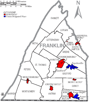
Under Pennsylvania law, there are four types of incorporated municipalities: cities, boroughs, townships, and, in at most two cases, towns. The following boroughs and townships are located in Franklin County:
Boroughs
- Chambersburg (county seat)
- Greencastle
- Mercersburg
- Mont Alto
- Orrstown
- Shippensburg (mostly in Cumberland County)
- Waynesboro
Townships
Census-designated places
Census-designated places are geographical areas designated by the U.S. Census Bureau for the purposes of compiling demographic data. They are not actual jurisdictions under Pennsylvania law. Other unincorporated communities, such as villages, may be listed here as well.
Population ranking
The population ranking of the following table is based on the 2010 census of Franklin County.[17]
† county seat
| Rank | City/Town/etc. | Municipal type | Population (2010 Census)
|
|---|---|---|---|
| 1 | † Chambersburg | Borough | 20,268 |
| 2 | Waynesboro | Borough | 10,568 |
| 3 | Shippensburg (mostly in Cumberland County) | Borough | 5,492 |
| 4 | Greencastle | Borough | 3,996 |
| 5 | Fayetteville | CDP | 3,128 |
| 6 | State Line | CDP | 2,709 |
| 7 | Wayne Heights | CDP | 2,545 |
| 8 | Guilford | CDP | 2,138 |
| 9 | Mont Alto | Borough | 1,705 |
| 10 | Mercersburg | Borough | 1,561 |
| 11 | Scotland | CDP | 1,395 |
| 12 | Marion | CDP | 953 |
| 13 | Pen Mar | CDP | 929 |
| 14 | Rouzerville | CDP | 917 |
| 15 | Blue Ridge Summit | CDP | 891 |
| 16 | Fort Loudon | CDP | 886 |
| 17 | Orrstown | Borough | 262 |
See also
References
- ↑ "State & County QuickFacts". United States Census Bureau. Archived from the original on July 10, 2011. Retrieved November 17, 2013.
- ↑ "Find a County". National Association of Counties. Archived from the original on 2011-05-31. Retrieved 2011-06-07.
- ↑ Franklin County PA – default Archived 2011-08-06 at the Wayback Machine.. Co.franklin.pa.us. Retrieved on 2013-07-23.
- ↑ Gannett, Henry (1905). The Origin of Certain Place Names in the United States. Govt. Print. Off. p. 131.
- ↑ "2010 Census Gazetteer Files". United States Census Bureau. August 22, 2012. Retrieved March 7, 2015.
- ↑ "Population and Housing Unit Estimates". Retrieved March 30, 2018.
- ↑ "U.S. Decennial Census". United States Census Bureau. Archived from the original on May 12, 2015. Retrieved March 7, 2015.
- ↑ "Historical Census Browser". University of Virginia Library. Retrieved March 7, 2015.
- ↑ Forstall, Richard L., ed. (March 24, 1995). "Population of Counties by Decennial Census: 1900 to 1990". United States Census Bureau. Retrieved March 7, 2015.
- ↑ "Census 2000 PHC-T-4. Ranking Tables for Counties: 1990 and 2000" (PDF). United States Census Bureau. April 2, 2001. Retrieved March 7, 2015.
- ↑ "American FactFinder". United States Census Bureau. Archived from the original on 2013-09-11. Retrieved 2008-01-31.
- ↑ David Brooks (December 2001). "One Nation, Slightly Divisible". The Atlantic. Retrieved November 11, 2010.
- ↑ http://uselectionatlas.org/RESULTS
- ↑ "Franklin County, PA". www.franklincountypa.gov. Retrieved 2017-04-25.
- 1 2 Center, Legislativate Data Processing. "Find Your Legislator". The official website for the Pennsylvania General Assembly. Retrieved 2017-04-25.
- ↑ Lincoln Intermediate Unit 12 website accessed April 2010
- ↑ "Archived copy". Archived from the original on 2013-12-21. Retrieved 2013-02-10.
Municipalities and communities of Franklin County, Pennsylvania, United States | ||
|---|---|---|
| Boroughs | | |
| Townships | ||
| CDPs | ||
| Unincorporated communities |
| |
| Footnotes | ‡This populated place also has portions in an adjacent county or counties | |