Roxbury, Pennsylvania
| Roxbury, Pennsylvania | |
|---|---|
| Unincorporated community | |
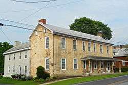 House in Roxbury | |
 Roxbury  Roxbury | |
| Coordinates: 40°6′37″N 77°39′43″W / 40.11028°N 77.66194°WCoordinates: 40°6′37″N 77°39′43″W / 40.11028°N 77.66194°W | |
| Country | United States |
| State | Pennsylvania |
| County | Franklin |
| Township | Lurgan |
| Elevation | 748 ft (228 m) |
| Time zone | UTC-5 (Eastern (EST)) |
| • Summer (DST) | UTC-4 (EDT) |
| ZIP code | 17251 |
| Area code(s) | 717 |
| GNIS feature ID | 1185584[1] |
Roxbury is an unincorporated community located off the Blue Mountain exit of the Pennsylvania Turnpike (Interstate 76) in Lurgan Township, Franklin County, Pennsylvania.[1] Route 641 and Route 997 meet there.
Roxbury was laid out about 1778.[2] A post office called Roxbury has been in operation since 1822.[3]
References
- 1 2 "Roxbury". Geographic Names Information System. United States Geological Survey.
- ↑ M'Cauley, I. H. (1878). Historical Sketch of Franklin County, Pennsylvania. Patriot. p. 217.
- ↑ "Franklin County". Jim Forte Postal History. Retrieved 19 June 2017.
Municipalities and communities of Franklin County, Pennsylvania, United States | ||
|---|---|---|
| Boroughs | 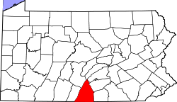 | |
| Townships | ||
| CDPs | ||
| Unincorporated communities |
| |
| Footnotes | ‡This populated place also has portions in an adjacent county or counties | |
This article is issued from
Wikipedia.
The text is licensed under Creative Commons - Attribution - Sharealike.
Additional terms may apply for the media files.