Burr's Ferry Bridge
| Burr's Ferry Bridge | |
|---|---|
 | |
| Coordinates | 31°03′50″N 93°31′23″W / 31.064°N 93.523°WCoordinates: 31°03′50″N 93°31′23″W / 31.064°N 93.523°W |
| Carries | TX 63 and LA 8 (2 lanes east and west) |
| Crosses | Sabine River |
| Locale | Between Burkeville, Texas and Burr Ferry, Louisiana |
| Maintained by | Louisiana DOTD, TxDOT |
| ID number | NW0214-04-005 (Texas) |
| Characteristics | |
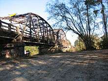
| Design | Parker through truss bridge |
| Longest span | 250 feet (76 m) |
| Clearance above | 12 feet 8 inches (4 m) |
| History | |
| Designer | Louisiana Highway Commission |
| Constructed by | W. Horace Williams Company |
| Construction start | 1936 |
| Construction end | 1937 |
|
Burr's Ferry Bridge | |
| Area | 1.1 acres (0.45 ha) |
| NRHP reference # |
98000562[1] 98000563[1] |
| Added to NRHP | May 18, 1998 |
 Burr's Ferry Bridge Location in Louisiana  Burr's Ferry Bridge Burr's Ferry Bridge (Texas)  Burr's Ferry Bridge Burr's Ferry Bridge (the US) | |
Burr's Ferry Bridge is a bridge on the Sabine River where LA 8 meets Texas State Highway 63 at the Louisiana and Texas state line between Burkeville, Texas and Burr Ferry, Louisiana.
The bridge includes three Parker through truss spans and 34 concrete girder spans. The center span is a 250 feet (76 m) riveted Parker through truss; the other two main spans are 120 feet (37 m) in length.[2]
Gallery

See also
References
- 1 2 National Park Service (2013-11-02). "National Register Information System". National Register of Historic Places. National Park Service.
- ↑ "Burr's Ferry Bridge" (PDF). State of Louisiana's Division of Historic Preservation. 1998. Retrieved June 8, 2007. with two photos, a map, and plans
External links
| Wikimedia Commons has media related to Burr's Ferry Bridge. |
- U.S. Geological Survey Geographic Names Information System: Burr Ferry Bridge, Louisiana
- U.S. Geological Survey Geographic Names Information System: Burrs Ferry Bridge, Texas
- Sabine River History: Newton County, Texas


This article is issued from
Wikipedia.
The text is licensed under Creative Commons - Attribution - Sharealike.
Additional terms may apply for the media files.