National Register of Historic Places listings in Bee County, Texas

Location of Bee County in Texas
This is a list of the National Register of Historic Places listings in Bee County, Texas.
This is intended to be a complete list of properties listed on the National Register of Historic Places in Bee County, Texas. There are 13 properties listed on the National Register in the county. Five properties are designated as Recorded Texas Historic Landmarks including one that is also a State Antiquities Landmark.
- This National Park Service list is complete through NPS recent listings posted October 11, 2018.[1]
Current listings
The locations of National Register properties may be seen in a mapping service provided.[2]
| [3] | Name on the Register[4] | Image | Date listed[5] | Location | City or town | Description |
|---|---|---|---|---|---|---|
| 1 | Bee County Courthouse | 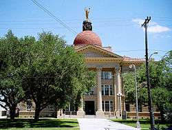 |
February 9, 2001 (#01000105) |
105 W. Corpus Christi St. 28°24′04″N 97°44′53″W / 28.401111°N 97.748056°W |
Beeville | State Antiquities Landmark, Recorded Texas Historic Landmark |
| 2 | Beeville Post Office | 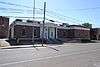 |
April 4, 2007 (#07000272) |
111 N. St. Mary's St. 28°24′10″N 97°44′55″W / 28.40264°N 97.74873°W |
Beeville | Recorded Texas Historic Landmark |
| 3 | Lott-Canada School | 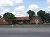 |
December 7, 2010 (#10000981) |
900 W. Corpus Christi St. 28°23′53″N 97°45′26″W / 28.398194°N 97.757153°W |
Beeville | Historic and Architectural Resources Associated with the Rosenwald School Program in Texas MPS; currently a branch location for the Coastal Bend College. |
| 4 | Medio Creek Bridge | 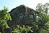 |
October 13, 1988 (#88002000) |
CR 241 28°31′46″N 97°47′39″W / 28.529444°N 97.794167°W |
Normanna | Recorded Texas Historic Landmark; also called Normanna Bridge |
| 5 | NAS Chase Field-Building 1001 | 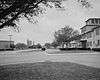 |
February 23, 1994 (#94000050) |
Independence St., 0.45 mi. S of jct. with TX 202 28°22′24″N 97°39′49″W / 28.373333°N 97.663611°W |
Beeville | Administration Building |
| 6 | NAS Chase Field-Building 1009 | 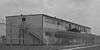 |
February 23, 1994 (#94000051) |
Essex St. 0.68 mi. SSE of the jct. of TX 202 and Independence St. 28°22′23″N 97°39′41″W / 28.373056°N 97.661389°W |
Beeville | Enlisted WAVES Barracks |
| 7 | NAS Chase Field-Building 1015 | February 23, 1994 (#94000052) |
Byrd St. 0.82 mi. SSE of jct. of TX 202 and Independence St. 28°22′09″N 97°39′39″W / 28.369167°N 97.660833°W |
Beeville | Landplane Hangar | |
| 8 | NAS Chase Field-Building 1040 | February 23, 1994 (#94000053) |
Enterprise St. 0.37 mi. SSE of the jct. of TX 202 and Independence St. 28°22′32″N 97°39′46″W / 28.375556°N 97.662778°W |
Beeville | Auditorium/Gym/Chapel | |
| 9 | NAS Chase Field-Building 1042 | 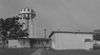 |
February 23, 1994 (#94000054) |
Ofstie Rd. 0.6 mi. SSE of the jct. of TX 202 and Independence St. 28°22′22″N 97°39′39″W / 28.372778°N 97.660833°W |
Beeville | Brig |
| 10 | NAS Chase Field-Quarters R | 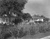 |
February 23, 1994 (#94000055) |
Essex St. 0.43 mi. SSW of the jct. of TX 202 and Independence St. 28°22′28″N 97°39′51″W / 28.374444°N 97.664167°W |
Beeville | Commanding Officer's Quarters |
| 11 | NAS Chase Field-Quarters S | 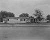 |
February 23, 1994 (#94000056) |
Essex St. 0.45 mi. SSW of the jct. of TX 202 and Independence St. 28°22′29″N 97°39′55″W / 28.374722°N 97.665139°W |
Beeville | Executive Officer's Quarters |
| 12 | Praeger Building | 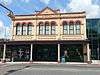 |
September 9, 1982 (#82004490) |
110 W. Corpus Christi St. 28°24′06″N 97°44′57″W / 28.401667°N 97.749167°W |
Beeville | Recorded Texas Historic Landmark |
| 13 | Rialto Theater | 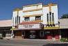 |
November 21, 2001 (#01001265) |
112-114 N. Washington St. 28°24′08″N 97°44′57″W / 28.402222°N 97.749167°W |
Beeville | Recorded Texas Historic Landmark; also called Hall-Rialto Theater |
See also
References
- ↑ "National Register of Historic Places: Weekly List Actions". National Park Service, United States Department of the Interior. Retrieved on October 11, 2018.
- ↑ The latitude and longitude information provided in this table was derived originally from the National Register Information System, which has been found to be fairly accurate for about 99% of listings. For about 1% of NRIS original coordinates, experience has shown that one or both coordinates are typos or otherwise extremely far off; some corrections may have been made. A more subtle problem causes many locations to be off by up to 150 yards, depending on location in the country: most NRIS coordinates were derived from tracing out latitude and longitudes from USGS topographical quadrant maps created under the North American Datum of 1927, which differs from the current, highly accurate WGS84 GPS system used by most on-line maps. Chicago is about right, but NRIS longitudes in Washington are higher by about 4.5 seconds, and are lower by about 2.0 seconds in Maine. Latitudes differ by about 1.0 second in Florida. Some locations in this table may have been corrected to current GPS standards.
- ↑ Numbers represent an ordering by significant words. Various colorings, defined here, differentiate National Historic Landmarks and historic districts from other NRHP buildings, structures, sites or objects.
- ↑ National Park Service (2010-07-09). "National Register Information System". National Register of Historic Places. National Park Service.
- ↑ The eight-digit number below each date is the number assigned to each location in the National Register Information System database, which can be viewed by clicking the number.
External links
![]()


Municipalities and communities of Bee County, Texas, United States | ||
|---|---|---|
| City | 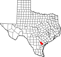 | |
| CDPs | ||
| Unincorporated community | ||
This article is issued from
Wikipedia.
The text is licensed under Creative Commons - Attribution - Sharealike.
Additional terms may apply for the media files.