National Register of Historic Places listings in Hidalgo County, Texas
This is a list of the National Register of Historic Places listings in Hidalgo County, Texas
This is intended to be a complete list of properties and districts listed on the National Register of Historic Places in Hidalgo County, Texas. There are four districts and 18 individual properties listed on the National Register in the county. One property is a State Antiquities Landmark. Seven properties are designated Recorded Texas Historic Landmarks (RTHLs) while two districts and two more individual properties contain RTHLs within their boundaries.
- This National Park Service list is complete through NPS recent listings posted October 11, 2018.[1]
Current listings
The locations of National Register properties and districts may be seen in a mapping service provided.[2]
| [3] | Name on the Register[4] | Image | Date listed[5] | Location | City or town | Description |
|---|---|---|---|---|---|---|
| 1 | Border Theater | 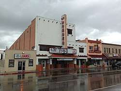 |
August 28, 1998 (#98001124) |
905 North Conway Blvd. 26°12′54″N 98°19′33″W / 26.215°N 98.325833°W |
Mission | Recorded Texas Historic Landmark |
| 2 | Casa de Palmas | 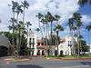 |
April 18, 2003 (#03000276) |
101 N. Main St. 26°12′17″N 98°14′04″W / 26.2048°N 98.234333°W |
McAllen | Recorded Texas Historic Landmark |
| 3 | Cine El Rey | 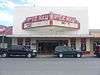 |
April 26, 2002 (#02000402) |
311 S. 17th St. 26°12′05″N 98°14′17″W / 26.20147°N 98.23804°W |
McAllen | |
| 4 | Cortez Hotel | 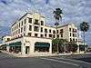 |
December 23, 2004 (#04001397) |
260 S. Texas Ave. 26°09′33″N 97°59′27″W / 26.15927°N 97.99091°W |
Weslaco | Recorded Texas Historic Landmark |
| 5 | El Sal Del Rey Archeological District | August 27, 1979 (#79002977) |
Address Restricted 26°32′16″N 98°03′24″W / 26.5379°N 98.0566°W |
Linn | ||
| 6 | Mary S. and Gordon Griffin House | 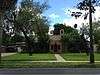 |
June 13, 2014 (#14000341) |
704 N. 15th Street 26°12′38″N 98°14′03″W / 26.210669°N 98.234119°W |
McAllen | |
| 7 | La Lomita Historic District |  |
May 28, 1975 (#75002165) |
5 mi (8.0 km). S of Mission on FM 1016 26°09′12″N 98°19′32″W / 26.15324°N 98.3256°W |
Mission | Includes Recorded Texas Historic Landmark |
| 8 | Lomita Boulevard Commercial Historic District | 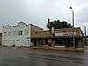 |
September 18, 1998 (#98001184) |
400 to 700 Blocks N. Conway Blvd. 26°12′40″N 98°19′34″W / 26.211111°N 98.326111°W |
Mission | |
| 9 | Louisiana-Rio Grande Canal Company Irrigation System | 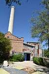 |
November 8, 1995 (#95001284) |
S. 2nd St. at River Levee 26°05′49″N 98°15′42″W / 26.09689°N 98.26177°W |
Hidalgo | Address is for First pump station. Listings also includes second pump station in McAllen and approximately 45000 acres of canals in southern Hidalgo County. |
| 10 | M and J Nelson Building | 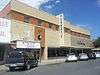 |
October 1, 2008 (#08000962) |
300-308 S. 14th St. 26°12′05″N 98°14′06″W / 26.201428°N 98.234917°W |
McAllen | Recorded Texas Historic Landmark |
| 11 | McAllen Ranch | April 18, 2007 (#07000337) |
FM 1017, 13 mi (21 km). W of TX 281 26°37′25″N 98°18′02″W / 26.62359°N 98.3005°W |
Linn | ||
| 12 | Sam and Marjorie Miller House | 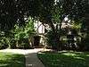 |
July 9, 1997 (#97000780) |
707 N. 15th St. 26°12′39″N 98°14′04″W / 26.210833°N 98.234444°W |
McAllen | Recorded Texas Historic Landmark |
| 13 | Mission Canal Company Second Lift Pumphouse |  |
August 30, 2002 (#02000910) |
6th St. and Canal 26°12′43″N 98°19′51″W / 26.211944°N 98.330833°W |
Mission | |
| 14 | Mission Citrus Growers Union Packing Shed | 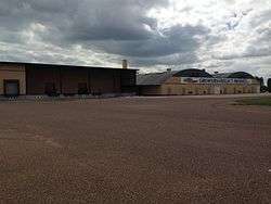 |
August 30, 2002 (#02000911) |
824 W. Business TX 83 26°12′56″N 98°19′56″W / 26.215556°N 98.332222°W |
Mission | |
| 15 | Oblate Park Historic District | 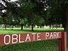 |
December 22, 2005 (#05001459) |
Roughly bounded by Doherty, Keralum, W. 16th St. and W 10th St. 26°13′13″N 98°19′17″W / 26.220278°N 98.321389°W |
Mission | Includes Recorded Texas Historic Landmark |
| 16 | Old Hidalgo Courthouse and Buildings | 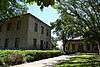 |
February 1, 1980 (#80004136) |
Flora and 1st Sts. 26°05′57″N 98°15′44″W / 26.09927°N 98.26212°W |
Hidalgo | Includes Recorded Texas Historic Landmarks |
| 17 | Old Hidalgo School | October 24, 1979 (#79002976) |
Flora and 4th Sts. 26°05′55″N 98°15′35″W / 26.0986°N 98.2597°W |
Hidalgo | State Antiquities Landmark | |
| 18 | Rancho Toluca | July 21, 1983 (#83004513) |
FM 1015 26°04′14″N 97°56′43″W / 26.07049°N 97.9454°W |
Progreso | Includes Recorded Texas Historic Landmarks | |
| 19 | Roosevelt School Auditorium and Classroom Addition | 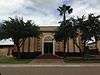 |
August 30, 2002 (#02000909) |
407 E. 3rd St. 26°12′30″N 98°19′21″W / 26.20823°N 98.32259°W |
Mission | |
| 20 | John Shary Building | August 30, 2002 (#02000907) |
900 Doherty 26°12′53″N 98°19′28″W / 26.21483°N 98.32443°W |
Mission | Recorded Texas Historic Landmark | |
| 21 | Teatro La Paz | 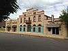 |
August 30, 2002 (#02000908) |
514,516,518 Doherty 26°12′39″N 98°19′31″W / 26.21095°N 98.32517°W |
Mission | Recorded Texas Historic Landmark |
| 22 | Valley Fruit Company | December 7, 2011 (#11000897) |
724 N. Cage Blvd. 26°12′06″N 98°10′54″W / 26.20172°N 98.18177°W |
Pharr |
See also
References
- ↑ "National Register of Historic Places: Weekly List Actions". National Park Service, United States Department of the Interior. Retrieved on October 11, 2018.
- ↑ The latitude and longitude information provided in this table was derived originally from the National Register Information System, which has been found to be fairly accurate for about 99% of listings. For about 1% of NRIS original coordinates, experience has shown that one or both coordinates are typos or otherwise extremely far off; some corrections may have been made. A more subtle problem causes many locations to be off by up to 150 yards, depending on location in the country: most NRIS coordinates were derived from tracing out latitude and longitudes from USGS topographical quadrant maps created under the North American Datum of 1927, which differs from the current, highly accurate WGS84 GPS system used by most on-line maps. Chicago is about right, but NRIS longitudes in Washington are higher by about 4.5 seconds, and are lower by about 2.0 seconds in Maine. Latitudes differ by about 1.0 second in Florida. Some locations in this table may have been corrected to current GPS standards.
- ↑ Numbers represent an ordering by significant words. Various colorings, defined here, differentiate National Historic Landmarks and historic districts from other NRHP buildings, structures, sites or objects.
- ↑ National Park Service (2010-07-09). "National Register Information System". National Register of Historic Places. National Park Service.
- ↑ The eight-digit number below each date is the number assigned to each location in the National Register Information System database, which can be viewed by clicking the number.
External links
![]()
Places adjacent to National Register of Historic Places listings in Hidalgo County, Texas | ||||||||||
|---|---|---|---|---|---|---|---|---|---|---|
| ||||||||||

