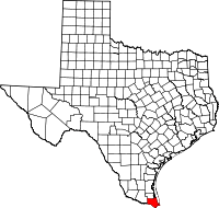
National Register of Historic Places listings in Cameron County, Texas

This is a list of the National Register of Historic Places listings in Cameron County, Texas.
This is intended to be a complete list of properties and districts listed on the National Register of Historic Places in Cameron County, Texas. There are one district, 27 individual properties, and one former property listed on the National Register in the county. The district, three individually listed properties, and the former property are or were National Historic Landmarks, two of which are also part of a National Historical Park. Two properties are listed as State Antiquities Landmarks one of which, along with 12 others, are Recorded Texas Historic Landmarks. The district includes additional Recorded Texas Historic Landmarks.
- This National Park Service list is complete through NPS recent listings posted October 11, 2018.[1]
Current listings
The publicly disclosed locations of National Register properties and districts may be seen in a mapping service provided.[2]
| [3] | Name on the Register[4] | Image | Date listed[5] | Location | City or town | Description |
|---|---|---|---|---|---|---|
| 1 | Brazos Santiago Depot |  |
July 14, 1971 (#71000923) |
Address restricted[6] |
Port Isabel | |
| 2 | Samuel Wallace Brooks House | 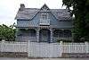 |
November 22, 1988 (#88002530) |
623 E St. Charles St. 25°54′14″N 97°30′12″W / 25.90375°N 97.503472°W |
Brownsville | |
| 3 | Brown-Wagner House | 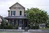 |
August 29, 1977 (#77001430) |
245 E St. Charles St. 25°54′23″N 97°30′22″W / 25.90625°N 97.506042°W |
Brownsville | Recorded Texas Historic Landmark |
| 4 | Brownsville City Cemetery and Hebrew Cemetery |  |
March 31, 2010 (#10000143) |
Bound by E. 5th St., Madison St., E 2nd St., and Town Resaca 25°54′34″N 97°30′00″W / 25.909514°N 97.5°W |
Brownsville | |
| 5 | Brownsville Freight Depot and Warehouse District |  |
March 26, 2018 (#100002266) |
Roughly bounded by former RR alignment, E Fronton, E 4th & E 9th Sts. 25°54′09″N 97°30′22″W / 25.902504°N 97.506088°W |
Brownsville | |
| 6 | Old Brulay Plantation | October 10, 1975 (#75001961) |
East of Brownsville off of TX 4 25°51′16″N 97°24′01″W / 25.854531°N 97.400289°W |
Brownsville | Also known as the Nye Plantation[7] | |
| 7 | Cameron County Courthouse | 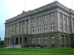 |
September 27, 1980 (#80004084) |
1150 E Madison St. 25°54′15″N 97°29′43″W / 25.904167°N 97.495347°W |
Brownsville | State Antiquities Landmark, Recorded Texas Historic Landmark |
| 8 | Old Cameron County Jail | 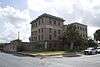 |
January 24, 1995 (#94001594) |
1201 E Van Buren 25°54′19″N 97°29′34″W / 25.905278°N 97.492847°W |
Brownsville | Recorded Texas Historic Landmark |
| 9 | Augustine Celaya House | 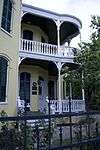 |
April 11, 1986 (#86000726) |
504 E St. Francis St. 25°54′13″N 97°30′19″W / 25.903681°N 97.505347°W |
Brownsville | Recorded Texas Historic Landmark |
| 10 | Celaya-Creager House | 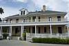 |
May 5, 1988 (#88000523) |
441 E Washington St. 25°54′25″N 97°30′09″W / 25.906806°N 97.5025°W |
Brownsville | |
| 11 | Fernandez and Laiseca Building | May 11, 2018 (#100002433) |
1142-1154 Madison St. 25°54′13″N 97°29′44″W / 25.903539°N 97.495647°W |
Brownsville | ||
| 11 | Miguel Fernandez Hide Yard | 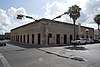 |
October 1, 1990 (#90001485) |
1101-1121 E Adams St. 25°54′11″N 97°29′51″W / 25.902947°N 97.497414°W |
Brownsville | also known as El Aleman |
| 12 | Fort Brown | 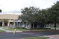 |
October 15, 1966 (#66000811) |
S edge of Brownsville off of International Blvd. 25°53′50″N 97°29′26″W / 25.897222°N 97.490556°W |
Brownsville | |
| 13 | M.E. and Estela Cueto Garcia House |  |
June 5, 2017 (#100001038) |
155 Calle Anacua 25°55′01″N 97°30′11″W / 25.916861°N 97.503116°W |
Brownsville | |
| 14 | Garcia Pasture Site | |
February 23, 1972 (#72001355) |
Address restricted[6] |
Port Isabel | |
| 15 | The Gem | 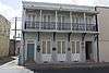 |
June 28, 1991 (#91000852) |
400 E 13th St. 25°54′00″N 97°29′52″W / 25.89989°N 97.49768°W |
Brownsville | Recorded Texas Historic Landmark |
| 16 | Hicks-Gregg House | 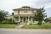 |
July 1, 2009 (#09000486) |
1249 W. Washington 25°55′06″N 97°30′56″W / 25.918375°N 97.515536°W |
Brownsville | Recorded Texas Historic Landmark |
| 17 | Immaculate Conception Church | 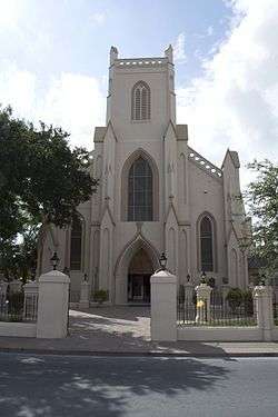 |
March 26, 1980 (#80004085) |
1218 E Jefferson St. 25°54′09″N 97°29′45″W / 25.9025°N 97.495972°W |
Brownsville | Recorded Texas Historic Landmark |
| 18 | La Madrilena | 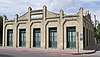 |
November 17, 1988 (#88002384) |
1002 E Madison 25°54′17″N 97°29′49″W / 25.904722°N 97.496806°W |
Brownsville | Recorded Texas Historic Landmark |
| 19 | Manautou House | 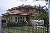 |
July 14, 1983 (#83003130) |
5 E Elizabeth St. 25°54′33″N 97°30′23″W / 25.909236°N 97.506458°W |
Brownsville | Recorded Texas Historic Landmark |
| 20 | McNair House | 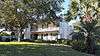 |
November 24, 2015 (#15000836) |
39 Sunset Drive 25°55′08″N 97°29′52″W / 25.918960°N 97.497848°W |
Brownsville | Recorded Texas Historic Landmark |
| 21 | Morris-Browne House | 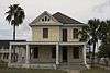 |
October 25, 2006 (#06000955) |
204 E Levee St. 25°54′25″N 97°30′22″W / 25.90695°N 97.506111°W |
Brownsville | |
| 22 | La Nueva Libertad | 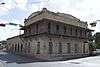 |
April 11, 1986 (#84001628) |
1301 E Madison 25°54′10″N 97°29′40″W / 25.902778°N 97.494375°W |
Brownsville | Recorded Texas Historic Landmark; also known as the Cueto Building |
| 23 | Palmito Ranch Battlefield | October 15, 1996 (#93000266) |
Between TX 4 and the Rio Grande, 12 mi. E of Brownsville 25°56′48″N 97°17′07″W / 25.946667°N 97.285278°W |
Brownsville | ||
| 24 | Palo Alto Battlefield National Historical Park |  |
October 15, 1966 (#66000812) |
6.3 miles N of Brownsville at intersection of FM 1847 and FM 511 26°01′04″N 97°28′50″W / 26.017886°N 97.480617°W |
Brownsville | |
| 25 | Point Isabel Lighthouse | 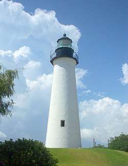 |
April 30, 1976 (#76002014) |
Corner of TX 100 and Garcia St. 26°04′39″N 97°12′27″W / 26.077633°N 97.207583°W |
Port Isabel | State Antiquities Landmark |
| 26 | Resaca de la Palma Battlefield | April 11, 1986 (#66000813) |
North of intersection of Paredes Line Rd and Price Rd. 25°56′15″N 97°29′10″W / 25.9375°N 97.486111°W |
Brownsville | Now a portion of the Palo Alto Battlefield National Historical Park | |
| 27 | Southern Pacific Railroad Passenger Depot | 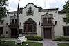 |
November 17, 1978 (#78002903) |
601 E Madison St. 25°54′27″N 97°29′57″W / 25.9075°N 97.499236°W |
Brownsville | Recorded Texas Historic Landmark |
| 28 | Charles Stillman House | 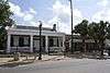 |
November 19, 1979 (#79003448) |
1305 E Washington St. 25°54′03″N 97°29′47″W / 25.900833°N 97.496319°W |
Brownsville | Recorded Texas Historic Landmark |
Former listing
| [3] | Name on the Register | Image | Date listed | Date removed | Location | City or town | Summary |
|---|---|---|---|---|---|---|---|
| 1 | USS Cabot | _underway_in_1988.JPEG) |
June 21, 1990 (#90000334) | August 7, 2001 | Port of Brownsville 25°57′03″N 97°24′39″W / 25.950835°N 97.410844°W |
Brownsville | Previously berthed in New Orleans until 1999; scrapped in 2002 |
See also
References
- ↑ "National Register of Historic Places: Weekly List Actions". National Park Service, United States Department of the Interior. Retrieved on October 11, 2018.
- ↑ The latitude and longitude information provided in this table was derived originally from the National Register Information System, which has been found to be fairly accurate for about 99% of listings. For about 1% of NRIS original coordinates, experience has shown that one or both coordinates are typos or otherwise extremely far off; some corrections may have been made. A more subtle problem causes many locations to be off by up to 150 yards, depending on location in the country: most NRIS coordinates were derived from tracing out latitude and longitudes from USGS topographical quadrant maps created under the North American Datum of 1927, which differs from the current, highly accurate WGS84 GPS system used by most on-line maps. Chicago is about right, but NRIS longitudes in Washington are higher by about 4.5 seconds, and are lower by about 2.0 seconds in Maine. Latitudes differ by about 1.0 second in Florida. Some locations in this table may have been corrected to current GPS standards.
- 1 2 Numbers represent an ordering by significant words. Various colorings, defined here, differentiate National Historic Landmarks and historic districts from other NRHP buildings, structures, sites or objects.
- ↑ National Park Service (2010-07-09). "National Register Information System". National Register of Historic Places. National Park Service.
- ↑ The eight-digit number below each date is the number assigned to each location in the National Register Information System database, which can be viewed by clicking the number.
- 1 2 Federal and state laws and practices restrict general public access to information regarding the specific location of this resource. In some cases, this is to protect archeological sites from vandalism, while in other cases it is restricted at the request of the owner. See: Knoerl, John; Miller, Diane; Shrimpton, Rebecca H. (1990), Guidelines for Restricting Information about Historic and Prehistoric Resources, National Register Bulletin (29), National Park Service, U.S. Department of the Interior, OCLC 20706997 .
- ↑
External links
![]()
Places adjacent to National Register of Historic Places listings in Cameron County, Texas | ||||||||||
|---|---|---|---|---|---|---|---|---|---|---|
| ||||||||||