National Register of Historic Places listings in Matagorda County, Texas

Location of Matagorda County in Texas
This is a list of the National Register of Historic Places listings in Matagorda County, Texas.
This is intended to be a complete list of properties and districts listed on the National Register of Historic Places in Matagorda County, Texas. There are two districts and ten individual properties listed on the National Register in the county. Nine individually listed properties are designated Recorded Texas Historic Landmarks while one district contains additional Recorded Texas Historic Landmarks.
- This National Park Service list is complete through NPS recent listings posted October 11, 2018.[1]
Current listings
The locations of National Register properties and districts may be seen in a mapping service provided.[2]
| [3] | Name on the Register[4] | Image | Date listed[5] | Location | City or town | Description |
|---|---|---|---|---|---|---|
| 1 | Bay City Post Office | 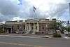 |
May 12, 2009 (#09000307) |
2100 Ave. F 28°58′59″N 95°58′12″W / 28.982953°N 95.970053°W |
Bay City | |
| 2 | Bay City USO Building | 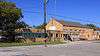 |
June 14, 2006 (#06000512) |
2105 Ave. M 28°59′04″N 95°57′44″W / 28.984444°N 95.962222°W |
Bay City | Recorded Texas Historic Landmark |
| 3 | Blessing Masonic Lodge No. 411 | .jpg) |
February 4, 2011 (#10001222) |
619 Ave B, FM 616 28°52′34″N 96°13′08″W / 28.876111°N 96.218958°W |
Blessing | Recorded Texas Historic Landmark |
| 4 | Christ Episcopal Church | 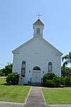 |
April 10, 2012 (#12000196) |
206 Cypress Street 28°41′33″N 95°58′03″W / 28.69238°N 95.96738°W |
Matagorda | Recorded Texas Historic Landmark |
| 5 | Hensley-Gusman House | 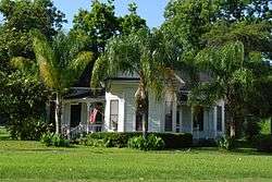 |
October 4, 2006 (#06000927) |
2120 Sixth St. 28°58′56″N 95°57′52″W / 28.982222°N 95.964444°W |
Bay City | Recorded Texas Historic Landmark |
| 6 | R.J. Hill Building | 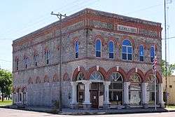 |
October 14, 2009 (#09000840) |
401 Commerce St. 28°42′01″N 96°12′54″W / 28.700369°N 96.2151°W |
Palacios | Recorded Texas Historic Landmark |
| 7 | Judge William Shields Holman House | 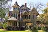 |
February 4, 2011 (#10001223) |
2504 Avenue K 28°58′43″N 95°57′51″W / 28.978611°N 95.964167°W |
Bay City | Recorded Texas Historic Landmark; part of South Side Residential Historic District |
| 8 | Hotel Blessing | .jpg) |
February 1, 1979 (#79002993) |
Ave. B 28°52′17″N 96°13′19″W / 28.871389°N 96.221944°W |
Blessing | Recorded Texas Historic Landmark |
| 9 | Luther Hotel | 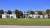 |
May 10, 2010 (#10000251) |
408 S Bay Blvd. 28°41′58″N 96°12′57″W / 28.699444°N 96.215833°W |
Palacios | Recorded Texas Historic Landmark |
| 10 | Matagorda Cemetery | 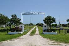 |
June 15, 2006 (#06000511) |
Jct. of TX 60 at Matagorda Cty Rds 259 and 260 28°42′10″N 95°57′20″W / 28.702778°N 95.955556°W |
Matagorda | |
| 11 | Matagorda County Monument | 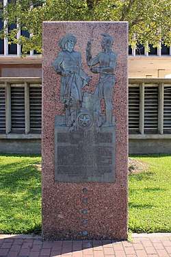 |
April 19, 2018 (#100002351) |
1700 7th St. 28°58′58″N 95°58′11″W / 28.982859°N 95.969634°W |
Bay City | |
| 12 | Price-Farwell House |  |
October 14, 2009 (#09000841) |
308 S. Bay Blvd. 28°41′55″N 96°12′50″W / 28.698625°N 96.213969°W |
Palacios | Recorded Texas Historic Landmark |
| 13 | South Side Residential Historic District |  |
May 30, 2007 (#07000496) |
Roughly bounded by Ave. F, 2nd St., Ave. G, Ave. K, 4th St., Ave J, 5th St., 4th St. 28°48′57″N 95°57′59″W / 28.815833°N 95.966389°W |
Bay City | Includes Recorded Texas Historic Landmark |
See also
References
- ↑ "National Register of Historic Places: Weekly List Actions". National Park Service, United States Department of the Interior. Retrieved on October 11, 2018.
- ↑ The latitude and longitude information provided in this table was derived originally from the National Register Information System, which has been found to be fairly accurate for about 99% of listings. For about 1% of NRIS original coordinates, experience has shown that one or both coordinates are typos or otherwise extremely far off; some corrections may have been made. A more subtle problem causes many locations to be off by up to 150 yards, depending on location in the country: most NRIS coordinates were derived from tracing out latitude and longitudes from USGS topographical quadrant maps created under the North American Datum of 1927, which differs from the current, highly accurate WGS84 GPS system used by most on-line maps. Chicago is about right, but NRIS longitudes in Washington are higher by about 4.5 seconds, and are lower by about 2.0 seconds in Maine. Latitudes differ by about 1.0 second in Florida. Some locations in this table may have been corrected to current GPS standards.
- ↑ Numbers represent an ordering by significant words. Various colorings, defined here, differentiate National Historic Landmarks and historic districts from other NRHP buildings, structures, sites or objects.
- ↑ National Park Service (2010-07-09). "National Register Information System". National Register of Historic Places. National Park Service.
- ↑ The eight-digit number below each date is the number assigned to each location in the National Register Information System database, which can be viewed by clicking the number.
External links
![]()
Places adjacent to National Register of Historic Places listings in Matagorda County, Texas | ||||||||||
|---|---|---|---|---|---|---|---|---|---|---|
| ||||||||||


Municipalities and communities of Matagorda County, Texas, United States | ||
|---|---|---|
| Cities | 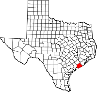 | |
| CDPs | ||
| Other unincorporated communities | ||
This article is issued from
Wikipedia.
The text is licensed under Creative Commons - Attribution - Sharealike.
Additional terms may apply for the media files.