| [3] |
Name on the Register[4] |
Image |
Date listed[5] |
Location |
City or town |
Description |
|---|
| 1 |
Abita Springs Historic District |
|
March 12, 1982
(#82004622) |
Louisiana Highways 36, 59, and 435
30°28′35″N 90°02′13″W / 30.476389°N 90.036944°W / 30.476389; -90.036944 (Abita Springs Historic District) |
Abita Springs |
|
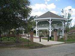
| 2 |
Abita Springs Pavilion |
|
August 19, 1975
(#75002062) |
Northwestern end of Main St.
30°28′48″N 90°02′25″W / 30.48°N 90.040278°W / 30.48; -90.040278 (Abita Springs Pavilion) |
Abita Springs |
|
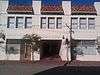
| 3 |
Arcade Theater |
|
August 29, 1997
(#97000966) |
2247-2251 Carey St.
30°16′23″N 89°47′02″W / 30.273056°N 89.783889°W / 30.273056; -89.783889 (Arcade Theater) |
Slidell |
|
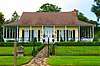
| 4 |
Bertus-Ducatel House |
|
March 5, 1998
(#98000182) |
1721 Lakeshore Dr.
30°21′03″N 90°03′52″W / 30.350833°N 90.064444°W / 30.350833; -90.064444 (Bertus-Ducatel House) |
Mandeville |
|
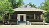
| 5 |
Bogue Falaya Park |
|
August 17, 2017
(#100001483) |
213 Park Dr.
30°28′15″N 90°05′40″W / 30.47083°N 90.094581°W / 30.47083; -90.094581 (Bogue Falaya Park) |
Covington |
|
| 6 |
Camp Salmen House |
|
April 24, 2006
(#06000323) |
35122 Camp Salmen Rd.
30°17′26″N 89°49′30″W / 30.290556°N 89.825°W / 30.290556; -89.825 (Camp Salmen House) |
Slidell |
|
| 7 |
Christ Episcopal Church |
|
April 17, 1980
(#80004253) |
120 N. New Hampshire St.
30°28′20″N 90°05′06″W / 30.472222°N 90.085°W / 30.472222; -90.085 (Christ Episcopal Church) |
Covington |
|
| 8 |
Francois Cousin House |
|
January 26, 2001
(#01000008) |
58148 Gwin Rd.
30°16′15″N 89°50′05″W / 30.270833°N 89.834722°W / 30.270833; -89.834722 (Francois Cousin House) |
Slidell |
|
| 9 |
Francois Cousin House |
|
September 16, 2002
(#02000982) |
28061 Main St.
30°18′38″N 89°56′06″W / 30.310556°N 89.935°W / 30.310556; -89.935 (Francois Cousin House) |
Lacombe |
|
| 10 |
Dendinger House |
|
September 22, 1992
(#92001252) |
206 Covington St.
30°24′36″N 90°09′38″W / 30.41°N 90.160556°W / 30.41; -90.160556 (Dendinger House) |
Madisonville |
|
| 11 |
Dew Drop Social and Benevolent Hall |
|
September 22, 2000
(#00001145) |
400 block of Lamarque St.
30°21′20″N 90°03′44″W / 30.355556°N 90.062222°W / 30.355556; -90.062222 (Dew Drop Social and Benevolent Hall) |
Mandeville |
|
| 12 |
Division of St. John Historic District |
|
December 6, 1982
(#82000461) |
U.S. Route 190 and Louisiana Highway 21
30°28′33″N 90°05′38″W / 30.475833°N 90.093889°W / 30.475833; -90.093889 (Division of St. John Historic District) |
Covington |
|
| 13 |
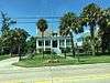
Flagstaff |
|
September 15, 1983
(#83000543) |
1815 Lakeshore Dr.
30°21′06″N 90°03′55″W / 30.351667°N 90.065278°W / 30.351667; -90.065278 (Flagstaff) |
Mandeville |
|
| 14 |
Fontainebleau State Park |
|
August 10, 1999
(#99000256) |
67825 U.S. Route 190
30°20′11″N 90°01′53″W / 30.336389°N 90.031389°W / 30.336389; -90.031389 (Fontainebleau State Park) |
Mandeville |
|
| 15 |
Frederick House |
|
August 11, 1982
(#82004624) |
238 Vermont St.
30°28′14″N 90°05′48″W / 30.470556°N 90.096667°W / 30.470556; -90.096667 (Frederick House) |
Covington |
|
| 16 |
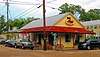
Griffin's Bakery |
|
December 1, 1997
(#97001423) |
301 Lafitte St.
30°21′21″N 90°04′03″W / 30.355833°N 90.0675°W / 30.355833; -90.0675 (Griffin's Bakery) |
Mandeville |
|
| 17 |
Haaswood Store |
|
July 15, 2009
(#09000518) |
62011 Louisiana Highway 1091
30°20′06″N 89°44′52″W / 30.334883°N 89.747911°W / 30.334883; -89.747911 (Haaswood Store) |
Pearl River |
|
| 18 |
Jay House |
|
May 29, 1998
(#98000593) |
Facing the Tchefuncte River, within Fairview-Riverside State Park
30°24′28″N 90°08′34″W / 30.407778°N 90.142778°W / 30.407778; -90.142778 (Jay House) |
Madisonville |
Also known as the "Otis House." |
| 19 |
Johnson House |
|
December 27, 2002
(#02001602) |
402 Lafitte St.
30°21′28″N 90°04′03″W / 30.357778°N 90.0675°W / 30.357778; -90.0675 (Johnson House) |
Mandeville |
|
| 20 |
Lacombe School |
|
November 8, 1990
(#90001742) |
Junction of St. Mary and 14th Sts.
30°18′56″N 89°56′37″W / 30.315556°N 89.943611°W / 30.315556; -89.943611 (Lacombe School) |
Lacombe |
|
| 21 |
Longbranch Annex |
|
July 21, 1983
(#83000544) |
Louisiana Highway 36 and Gordon St.
30°28′54″N 90°02′32″W / 30.481667°N 90.042222°W / 30.481667; -90.042222 (Longbranch Annex) |
Abita Springs |
|
| 22 |
Madisonville Bank |
|
December 28, 1983
(#83003636) |
400 Cedar St.
30°24′27″N 90°09′33″W / 30.4075°N 90.159167°W / 30.4075; -90.159167 (Madisonville Bank) |
Madisonville |
|
| 23 |
Madisonville Boarding House |
|
August 16, 1996
(#96000898) |
703 Main St.
30°24′16″N 90°09′25″W / 30.404444°N 90.156944°W / 30.404444; -90.156944 (Madisonville Boarding House) |
Madisonville |
|
| 24 |
Madisonville Town Hall |
|
November 8, 1990
(#90001741) |
203 Cedar
30°24′34″N 90°09′32″W / 30.409444°N 90.158889°W / 30.409444; -90.158889 (Madisonville Town Hall) |
Madisonville |
|
| 25 |
McCaleb House |
|
June 7, 1990
(#90000874) |
906 Main St.
30°24′10″N 90°09′25″W / 30.402778°N 90.156944°W / 30.402778; -90.156944 (McCaleb House) |
Madisonville |
|
| 26 |
Moore House |
|
April 20, 1983
(#83000545) |
1717 Lakeshore Dr.
30°21′03″N 90°03′52″W / 30.350833°N 90.064444°W / 30.350833; -90.064444 (Moore House) |
Mandeville |
|
| 27 |
Morel-Nott House |
|
June 6, 1980
(#80004254) |
Lakefront Dr.
30°21′31″N 90°04′45″W / 30.358611°N 90.079167°W / 30.358611; -90.079167 (Morel-Nott House) |
Mandeville |
|
| 28 |
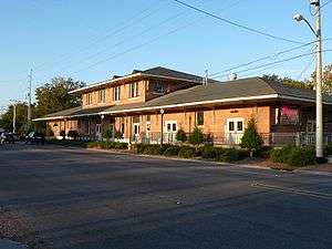
New Orleans and Northeastern Railroad-New Orleans and Great Northern Railroad Depot |
|
October 24, 1996
(#96001188) |
1809 Front St.
30°16′42″N 89°46′57″W / 30.278333°N 89.7825°W / 30.278333; -89.7825 (New Orleans and Northeastern Railroad-New Orleans and Great Northern Railroad Depot) |
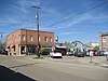
Slidell |
Train station built in 1913 and renovated in 1990s; continues in daily use for Amtrak's Crescent route. |
| 29 |
Pottery Hill |
|
October 13, 2011
(#11000736) |
Address Restricted
|
Mandeville |
|
| 30 |
Rankin House |
|
March 19, 1991
(#91000253) |
61467 Jacques Lemieux Boulevard
30°20′05″N 90°00′13″W / 30.334722°N 90.003611°W / 30.334722; -90.003611 (Rankin House) |
Mandeville |
|
| 31 |
Saint Joseph Abbey Church |
|
March 21, 2007
(#07000165) |
75376 River Rd.
30°31′35″N 90°06′41″W / 30.526389°N 90.111389°W / 30.526389; -90.111389 (Saint Joseph Abbey Church) |
Saint Benedict |
|
| 32 |
Saint Joseph Abbey Refectory |
|
March 21, 2007
(#07000166) |
75376 River Rd.
30°31′39″N 90°06′47″W / 30.5275°N 90.113056°W / 30.5275; -90.113056 (Saint Joseph Abbey Refectory) |
Saint Benedict |
|
| 33 |
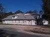
Salmen House |
|
October 10, 1996
(#96001082) |
2854 Front St.
30°16′01″N 89°47′18″W / 30.266944°N 89.788333°W / 30.266944; -89.788333 (Salmen House) |
Slidell |
|
| 34 |
Albert Salmen House |
|
January 21, 1993
(#92001822) |
213 Cleveland Ave.
30°16′08″N 89°47′09″W / 30.268889°N 89.785833°W / 30.268889; -89.785833 (Albert Salmen House) |
Slidell |
|
| 35 |
Fritz Salmen House |
|
November 21, 1991
(#91001722) |
127 Cleveland Ave.
30°16′10″N 89°47′12″W / 30.269444°N 89.786667°W / 30.269444; -89.786667 (Fritz Salmen House) |
Slidell |
|
| 36 |
Sardy House |
|
December 8, 1997
(#97001517) |
810 Main St.
30°24′12″N 90°09′25″W / 30.403333°N 90.156944°W / 30.403333; -90.156944 (Sardy House) |
Madisonville |
|
| 37 |
Sunnybrook |
|
August 29, 1979
(#79003123) |
North of Covington on Louisiana Highway 21
30°31′05″N 90°02′51″W / 30.518056°N 90.0475°W / 30.518056; -90.0475 (Sunnybrook) |
Covington |
|
| 38 |
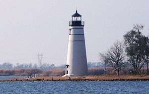
Tchefuncte River Range Rear Light |
|
July 14, 1986
(#86001684) |
Northern side of Lake Pontchartrain
30°22′44″N 90°10′11″W / 30.378889°N 90.169722°W / 30.378889; -90.169722 (Tchefuncte River Range Rear Light) |
Madisonville |
1868-vintage lighthouse, accessible only via water. Marked the entrance to the river from the Lake, replacing an 1838 light. |
| 39 |
Tchefuncte Site |
|
June 22, 2000
(#00000717) |
Address Restricted
|
Mandeville |
Archaeological site, excavated several times in the 20th century. The Tchefuncte culture ended about 200 CE. |


.jpg)

_DSC06691.jpg)