National Register of Historic Places listings in Fayette County, Texas

This is a list of the National Register of Historic Places listings in Fayette County, Texas.
This is intended to be a complete list of properties and districts listed on the National Register of Historic Places in Fayette County, Texas. There are four districts and 18 individual properties listed on the National Register in the county. The individually listed properties include one State Historic Site, five State Antiquities Landmarks, and seven Recorded Texas Historic Landmarks. Three districts together include numerous additional Recorded Texas Historic Landmarks. Three properties were formerly listed on the National Register including one that has since been relisted after relocation.
- This National Park Service list is complete through NPS recent listings posted October 11, 2018.[1]
Current listings
The locations of National Register properties and districts may be seen in a mapping service provided.[2]
| [3] | Name on the Register[4] | Image | Date listed[5] | Location | City or town | Description |
|---|---|---|---|---|---|---|
| 1 | Bedstead Truss Bridge | 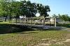 |
November 29, 2013 (#13000888) |
0.1 mi. NW. of jct. of Hillje & Kallus Sts. 29°40′27″N 96°54′39″W / 29.67405°N 96.91084°W |
Schulenburg | State Antiquities Landmark, Recorded Texas Historic Landmark; formerly the Mulberry Creek Bridge, originally listed on the National Register in 1975 (listing number 75001976), removed in May 2013 due to relocation. |
| 2 | Bethlehem Lutheran Church | .jpg) |
August 10, 1978 (#78002928) |
White St. 30°03′46″N 96°41′58″W / 30.062778°N 96.699444°W |
Round Top | Recorded Texas Historic Landmark |
| 3 | Cummins Creek Bridge | 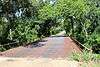 |
April 21, 1975 (#75001975) |
2 mi (3.2 km). NW of Round Top over Cummins Creek 30°04′07″N 96°43′09″W / 30.068611°N 96.719167°W |
Round Top | State Antiquities Landmark; replaced in 1996 |
| 4 | Dubina Historic District | 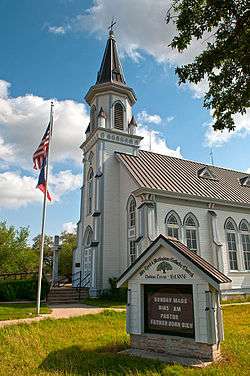 |
September 27, 2003 (#03000970) |
Roughly bounded by FM 1383 and Cty Rd. 480 29°43′44″N 96°50′08″W / 29.728889°N 96.835556°W |
Dubina | |
| 5 | East Navidad River Bridge | August 18, 2014 (#14000497) |
FM 1579 at East Navidad River 29°40′59″N 96°50′47″W / 29.682939°N 96.846481°W |
Schulenburg | ||
| 6 | Nathaniel W. Faison House | 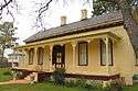 |
March 11, 2010 (#08000538) |
822 S. Jefferson 29°53′57″N 96°52′22″W / 29.899206°N 96.872764°W |
La Grange | Recorded Texas Historic Landmark |
| 7 | Fayette County Courthouse and Jail | .jpg) |
January 23, 1975 (#75001973) |
Courthouse Sq. and 104 Main St. 29°54′19″N 96°52′43″W / 29.905278°N 96.878611°W |
La Grange | State Antiquities Landmark, includes Recorded Texas Historic Landmark; part of Fayette County Courthouse Square Historic District |
| 8 | Fayette County Courthouse Square Historic District | January 16, 2001 (#00001664) |
Roughly bounded by Main, Lafayette, Franklin, Colorado, Jefferson, Washington, and Crockett Sts. 29°54′17″N 96°52′39″W / 29.904722°N 96.8775°W |
La Grange | Includes Recorded Texas Historic Landmarks | |
| 9 | Fayetteville Historic District | 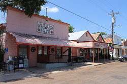 |
July 10, 2008 (#08000657) |
Roughly bounded by E. Bell, N. Thompson (FM 1291), E. Fayette, E. Main (SH 159), Post Oak Lane, 29°54′26″N 96°40′26″W / 29.90732°N 96.67396°W |
Fayetteville | Includes Recorded Texas Historic Landmarks |
| 10 | Flatonia Historic District | June 26, 2017 (#100001223) |
Roughly bounded by N. Main, 7th, Middle, Market, 6th, Penn, S. Main & Faires Sts. 29°41′15″N 97°06′31″W / 29.687381°N 97.108485°W |
Flatonia | Includes Recorded Texas Historic Landmarks | |
| 11 | Henry L. Kreische Brewery and House | 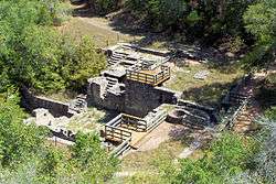 |
April 16, 1975 (#75001974) |
S of La Grange off U.S. 77 on Monument Hill 29°53′23″N 96°52′29″W / 29.889722°N 96.874722°W |
La Grange | State Historic Site, State Antiquities Landmark |
| 12 | Nativity of Mary, Blessed Virgin Catholic Church | 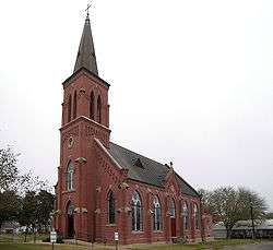 |
June 21, 1983 (#83003136) |
FM 2672 29°43′03″N 96°55′40″W / 29.7175°N 96.927778°W |
High Hill | |
| 13 | William Neese, Sr., Homestead | .jpg) |
February 18, 1975 (#75001977) |
On TX 237 30°01′06″N 96°43′54″W / 30.018333°N 96.731667°W |
Warrenton | |
| 14 | Sengelmann Hall and City Meat Market Building | .jpg) |
June 18, 2009 (#09000451) |
527 and 529-533 N. Main St. 29°40′47″N 96°54′19″W / 29.679822°N 96.905228°W |
Schulenburg | |
| 15 | Simon Pytlovany House | April 14, 1975 (#75001972) |
1.5 mi (2.4 km). S of Dubina on FR 1383 29°42′45″N 96°50′20″W / 29.7125°N 96.838889°W |
Dubina | ||
| 16 | Schulenburg Cotton Compress | 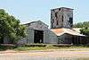 |
September 13, 1979 (#79002938) |
James and Main Sts. 29°40′43″N 96°54′45″W / 29.678611°N 96.9125°W |
Schulenburg | |
| 17 | St. James Episcopal Church | 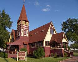 |
June 18, 1976 (#76002026) |
Monroe and Colorado Sts. 29°54′29″N 96°52′25″W / 29.908056°N 96.873611°W |
La Grange | Recorded Texas Historic Landmark |
| 18 | St. John the Baptist Catholic Church | 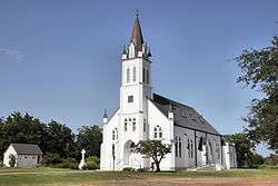 |
June 21, 1983 (#83003137) |
FM 1383 29°47′14″N 96°51′32″W / 29.787222°N 96.858889°W |
Ammannsville | |
| 19 | St. Mary's Church of the Assumption | 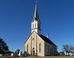 |
June 21, 1983 (#83003138) |
FM 1295 29°40′11″N 97°04′00″W / 29.669722°N 97.066667°W |
Praha | |
| 20 | State Highway 71 Bridge at the Colorado River | 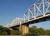 |
October 10, 1996 (#96001120) |
TX 71, .8 mi E of jct. with FM 609 29°54′05″N 96°53′12″W / 29.901389°N 96.886667°W |
La Grange | |
| 21 | Winedale Inn Complex | 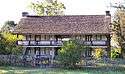 |
June 22, 1970 (#70000745) |
Off FM 1457 30°05′11″N 96°38′29″W / 30.086389°N 96.641389°W |
Winedale | State Antiquities Landmark, includes Recorded Texas Historic Landmark; now a division of The Center for American History, The University of Texas at Austin |
| 22 | Zapp Building | 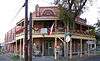 |
June 23, 1983 (#83003139) |
Fayette and Washington Sts. 29°54′15″N 96°40′37″W / 29.904167°N 96.676944°W |
Fayetteville | Recorded Texas Historic Landmark; part of Fayetteville Historic District; brick two-story Romanesque Revival mercantile building and emporium constructed in 1900. |
Former listings
| [3] | Name on the Register | Image | Date listed | Date removed | Location | City or town | Summary |
|---|---|---|---|---|---|---|---|
| 1 | Buckner's Creek Bridge | May 29, 1976 (#76002025) | April 21, 1988 | 10 mi. N of Flatonia over Buckner's Creek |
Flatonia | State Antiquities Landmark; demolished in 1988 | |
| 2 | Mount Eliza | July 17, 1978 (#78002927) | August 30, 1994 | Three miles south of LaGrange on US Highway 77 |
LaGrange | ||
| 3 | Mulberry Creek Bridge | 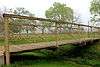 |
April 21, 1975 (#75001976) | May 21, 2013 | Wolters Park 29°40′27″N 96°54′39″W / 29.674167°N 96.910833°W |
Schulenburg | State Antiquities Landmark, Recorded Texas Historic Landmark; Pratt pony truss bridge originally located SW of Schulenburg on Old Praha Rd. Relocated in 2001 and relisted as Bedstead Truss Bridge. |
See also
References
- ↑ "National Register of Historic Places: Weekly List Actions". National Park Service, United States Department of the Interior. Retrieved on October 11, 2018.
- ↑ The latitude and longitude information provided in this table was derived originally from the National Register Information System, which has been found to be fairly accurate for about 99% of listings. For about 1% of NRIS original coordinates, experience has shown that one or both coordinates are typos or otherwise extremely far off; some corrections may have been made. A more subtle problem causes many locations to be off by up to 150 yards, depending on location in the country: most NRIS coordinates were derived from tracing out latitude and longitudes from USGS topographical quadrant maps created under the North American Datum of 1927, which differs from the current, highly accurate WGS84 GPS system used by most on-line maps. Chicago is about right, but NRIS longitudes in Washington are higher by about 4.5 seconds, and are lower by about 2.0 seconds in Maine. Latitudes differ by about 1.0 second in Florida. Some locations in this table may have been corrected to current GPS standards.
- 1 2 Numbers represent an ordering by significant words. Various colorings, defined here, differentiate National Historic Landmarks and historic districts from other NRHP buildings, structures, sites or objects.
- ↑ National Park Service (2010-07-09). "National Register Information System". National Register of Historic Places. National Park Service.
- ↑ The eight-digit number below each date is the number assigned to each location in the National Register Information System database, which can be viewed by clicking the number.
External links
![]()
Places adjacent to National Register of Historic Places listings in Fayette County, Texas | ||||||||||
|---|---|---|---|---|---|---|---|---|---|---|
| ||||||||||


Municipalities and communities of Fayette County, Texas, United States | ||
|---|---|---|
| Cities | 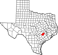 | |
| Towns | ||
| Unincorporated communities | ||
| Ghost Towns |
| |