National Register of Historic Places listings in Brazoria County, Texas

This is a list of the National Register of Historic Places listings in Brazoria County, Texas.
This is intended to be a complete list of properties and districts listed on the National Register of Historic Places in Brazoria County, Texas. There are two districts and nine individual properties listed on the National Register in the county. An additional property has been removed from the register. Among the individually listed properties are one State Historic Site, two State Antiquities Landmarks, and four Recorded Texas Historic Landmarks while one district contains additional Recorded Texas Historic Landmarks.
- This National Park Service list is complete through NPS recent listings posted October 11, 2018.[1]
Current listings
The publicly disclosed locations of National Register properties and districts may be seen in a mapping service provided.[2]
| [3] | Name on the Register[4] | Image | Date listed[5] | Location | City or town | Description |
|---|---|---|---|---|---|---|
| 1 | Brazoria Bridge | .jpg) |
June 14, 1991 (#91000783) |
0.9 mi. E of TX 36 on TX 332 29°03′15″N 95°33′25″W / 29.054167°N 95.556944°W |
Brazoria | Recorded Texas Historic Landmark |
| 2 | Alden B. Dow Office and Lake Jackson City Hall | 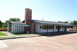 |
March 1, 2010 (#10000050) |
101 S. Parking Place 29°02′26″N 95°26′55″W / 29.04069°N 95.44856°W |
Lake Jackson | |
| 3 | Durazno Plantation | .jpg) |
September 2, 1980 (#80004081) |
S of Jones Creek off TX 36 28°57′22″N 95°26′57″W / 28.956111°N 95.449167°W |
Jones Creek | |
| 4 | East Columbia Historic District | .jpg) |
October 28, 1991 (#91001602) |
S. Main St. 29°08′31″N 95°36′54″W / 29.141944°N 95.615°W |
East Columbia | Includes Recorded Texas Historic Landmarks |
| 5 | Gazebo for James Richard Marmion | .jpg) |
October 22, 2004 (#04001173) |
1214 County Rd. 29°02′34″N 95°38′40″W / 29.042778°N 95.644444°W |
Sweeny | Sculpture by Dionicio Rodriguez |
| 6 | GEN. C. B. COMSTOCK (dredge) Shipwreck Site | 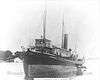 |
July 6, 1995 (#94001119) |
Address restricted[6] |
Surfside Beach | |
| 7 | John McCroskey Log House | 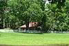 |
August 28, 1975 (#75001958) |
2 mi. NE of Cedar Lake on Stringfellow Ranch 28°56′22″N 95°36′54″W / 28.939444°N 95.615°W |
Cedar Lake | |
| 8 | Old Brazoria County Courthouse | 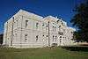 |
March 12, 1979 (#79002922) |
Public Sq. 29°10′08″N 95°25′52″W / 29.168889°N 95.431111°W |
Angleton | State Antiquities Landmark, Recorded Texas Historic Landmark |
| 9 | Palapa Table for James Richard Marmion | .jpg) |
October 22, 2004 (#04001172) |
1214 County Rd. 29°02′38″N 95°38′51″W / 29.043889°N 95.6475°W |
Sweeny | Sculpture by Dionicio Rodriguez |
| 10 | Ammon Underwood House | .jpg) |
June 24, 1976 (#76002011) |
505 Main St. 29°08′25″N 95°37′02″W / 29.140278°N 95.617222°W |
East Columbia | Recorded Texas Historic Landmark; relocated in 2005 due to river encroachment |
| 11 | Varner-Hogg Plantation | .jpg) |
April 9, 1980 (#80004082) |
2 mi. NE of West Columbia off FM 2852 29°09′47″N 95°38′25″W / 29.163056°N 95.640278°W |
West Columbia | State Historic Site, State Antiquities Landmark, Recorded Texas Historic Landmark |
Former listings
| [3] | Name on the Register | Image | Date listed | Date removed | Location | City or town | Summary |
|---|---|---|---|---|---|---|---|
| 1 | Ellerslie Plantation of Texas | December 21, 1978 (#78002898) | Unknown | SE of Brazoria off TX 36 |
Brazoria |
See also
References
- ↑ "National Register of Historic Places: Weekly List Actions". National Park Service, United States Department of the Interior. Retrieved on October 11, 2018.
- ↑ The latitude and longitude information provided in this table was derived originally from the National Register Information System, which has been found to be fairly accurate for about 99% of listings. For about 1% of NRIS original coordinates, experience has shown that one or both coordinates are typos or otherwise extremely far off; some corrections may have been made. A more subtle problem causes many locations to be off by up to 150 yards, depending on location in the country: most NRIS coordinates were derived from tracing out latitude and longitudes from USGS topographical quadrant maps created under the North American Datum of 1927, which differs from the current, highly accurate WGS84 GPS system used by most on-line maps. Chicago is about right, but NRIS longitudes in Washington are higher by about 4.5 seconds, and are lower by about 2.0 seconds in Maine. Latitudes differ by about 1.0 second in Florida. Some locations in this table may have been corrected to current GPS standards.
- 1 2 Numbers represent an ordering by significant words. Various colorings, defined here, differentiate National Historic Landmarks and historic districts from other NRHP buildings, structures, sites or objects.
- ↑ National Park Service (2010-07-09). "National Register Information System". National Register of Historic Places. National Park Service.
- ↑ The eight-digit number below each date is the number assigned to each location in the National Register Information System database, which can be viewed by clicking the number.
- ↑ Federal and state laws and practices restrict general public access to information regarding the specific location of this resource. In some cases, this is to protect archeological sites from vandalism, while in other cases it is restricted at the request of the owner. See: Knoerl, John; Miller, Diane; Shrimpton, Rebecca H. (1990), Guidelines for Restricting Information about Historic and Prehistoric Resources, National Register Bulletin (29), National Park Service, U.S. Department of the Interior, OCLC 20706997 .
External links
![]()
Places adjacent to National Register of Historic Places listings in Brazoria County, Texas | ||||||||||
|---|---|---|---|---|---|---|---|---|---|---|
| ||||||||||


Municipalities and communities of Brazoria County, Texas, United States | ||
|---|---|---|
| Cities |  | |
| Towns | ||
| Villages | ||
| CDPs | ||
| Other unincorporated communities | ||
| Footnotes | ‡This populated place also has portions in an adjacent county or counties | |