National Register of Historic Places listings in Bowie County, Texas

This is a list of the National Register of Historic Places listings in Bowie County, Texas.
This is intended to be a complete list of properties and districts listed on the National Register of Historic Places in Bowie County, Texas. There are one district and 15 individual properties listed on the National Register in the county. Seven individually listed properties are Recorded Texas Historic Landmarks including one that is also a State Antiquities Landmark. An additional property is also part of a State Antiquities Landmark.
- This National Park Service list is complete through NPS recent listings posted October 11, 2018.[1]
Current listings
The publicly disclosed locations of National Register properties and districts may be seen in a mapping service provided.[2]
| [3] | Name on the Register[4] | Image | Date listed[5] | Location | City or town | Description |
|---|---|---|---|---|---|---|
| 1 | Bowie County Jail | .jpg) |
November 16, 1977 (#77001429) |
Public Sq. 33°26′32″N 94°25′18″W / 33.442222°N 94.421667°W |
Boston | Part of a State Antiquities Landmark |
| 2 | Draughon-Moore House | 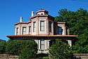 |
June 29, 1976 (#76002007) |
420 Pine St. 33°25′27″N 94°02′39″W / 33.424167°N 94.044167°W |
Texarkana | Recorded Texas Historic Landmark |
| 3 | Earl-Rochelle House | 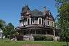 |
July 1, 1999 (#99000720) |
1920 Magnolia St. 33°26′08″N 94°02′37″W / 33.435556°N 94.043611°W |
Texarkana | Recorded Texas Historic Landmark |
| 4 | Garland Community School Teacherage | March 6, 2002 (#02000146) |
Farm to Market Road 1701, 2.5 mi. W of Dekalb 33°30′58″N 94°40′11″W / 33.516111°N 94.669722°W |
DeKalb | Historic and Architectural Resources Associated with the Rosenwald School Program in Texas | |
| 5 | Hotel Grim | .jpg) |
June 7, 2016 (#16000348) |
301 N. State Line Ave. 33°25′21″N 94°02′36″W / 33.422617°N 94.043337°W |
Texarkana | [6] |
| 6 | Hotel McCartney | 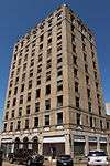 |
September 6, 1979 (#79002920) |
Corner of Front and Main Streets 33°25′13″N 94°02′35″W / 33.420278°N 94.043056°W |
Texarkana | |
| 7 | Offenhauser Insurance Building | 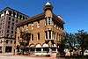 |
February 25, 1971 (#71000922) |
State Line Ave. and 3rd St. 33°25′20″N 94°02′36″W / 33.42232°N 94.04329°W |
Texarkana | Recorded Texas Historic Landmark |
| 8 | Rialto Building | 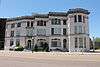 |
June 17, 1982 (#82004493) |
317 State Line Ave. 33°25′24″N 94°02′36″W / 33.42344°N 94.04329°W |
Texarkana | Recorded Texas Historic Landmark |
| 9 | Roseborough Lake Site |  |
July 6, 1976 (#76002008) |
Address restricted[7] |
Texarkana | |
| 10 | Saenger Theater | 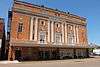 |
July 12, 1978 (#78002897) |
219 Main St. 33°25′18″N 94°02′41″W / 33.42177°N 94.04463°W |
Texarkana | State Antiquities Landmark, Recorded Texas Historic Landmark |
| 11 | Texarkana Junior College and Texas High School | 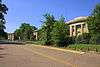 |
March 31, 2014 (#14000102) |
W. 16th & Pine Sts. 33°26′02″N 94°03′04″W / 33.433947°N 94.051089°W |
Texarkana | |
| 12 | Texarkana Phase Archeological District | |
August 14, 1973 (#73001959) |
Address restricted[7] |
Texarkana | |
| 13 | Texarkana Union Station | 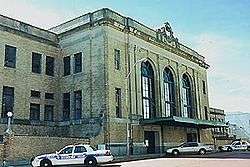 |
November 19, 1978 (#78000611) |
State Line and Front St. 33°25′12″N 94°02′33″W / 33.42°N 94.0425°W |
Texarkana | Extends into Miller County, Arkansas |
| 14 | Texarkana US Post Office and Courthouse | 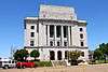 |
March 24, 2000 (#00000245) |
5th St. and State Line Ave. 33°25′32″N 94°02′35″W / 33.42542°N 94.04307°W |
Texarkana | Recorded Texas Historic Landmark; extends into Miller County, Arkansas |
| 15 | Tilson Mounds-Summerhill Lake Place (41BW14) | |
January 16, 1987 (#86003637) |
Address restricted[7] |
Texarkana | |
| 16 | Whitaker House | 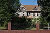 |
November 7, 1979 (#79002921) |
517 Whitaker St. 33°25′19″N 94°03′25″W / 33.421944°N 94.056944°W |
Texarkana | Recorded Texas Historic Landmark |
See also
References
- ↑ "National Register of Historic Places: Weekly List Actions". National Park Service, United States Department of the Interior. Retrieved on October 11, 2018.
- ↑ The latitude and longitude information provided in this table was derived originally from the National Register Information System, which has been found to be fairly accurate for about 99% of listings. For about 1% of NRIS original coordinates, experience has shown that one or both coordinates are typos or otherwise extremely far off; some corrections may have been made. A more subtle problem causes many locations to be off by up to 150 yards, depending on location in the country: most NRIS coordinates were derived from tracing out latitude and longitudes from USGS topographical quadrant maps created under the North American Datum of 1927, which differs from the current, highly accurate WGS84 GPS system used by most on-line maps. Chicago is about right, but NRIS longitudes in Washington are higher by about 4.5 seconds, and are lower by about 2.0 seconds in Maine. Latitudes differ by about 1.0 second in Florida. Some locations in this table may have been corrected to current GPS standards.
- ↑ Numbers represent an ordering by significant words. Various colorings, defined here, differentiate National Historic Landmarks and historic districts from other NRHP buildings, structures, sites or objects.
- ↑ National Park Service (2013-11-02). "National Register Information System". National Register of Historic Places. National Park Service.
- ↑ The eight-digit number below each date is the number assigned to each location in the National Register Information System database, which can be viewed by clicking the number.
- ↑
- 1 2 3 Federal and state laws and practices restrict general public access to information regarding the specific location of this resource. In some cases, this is to protect archeological sites from vandalism, while in other cases it is restricted at the request of the owner. See: Knoerl, John; Miller, Diane; Shrimpton, Rebecca H. (1990), Guidelines for Restricting Information about Historic and Prehistoric Resources, National Register Bulletin (29), National Park Service, U.S. Department of the Interior, OCLC 20706997 .
External links
![]()


Municipalities and communities of Bowie County, Texas, United States | ||
|---|---|---|
| Cities | 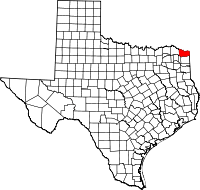 | |
| Unincorporated communities | ||
| Footnotes | ‡This populated place also has portions in an adjacent county or counties | |