National Register of Historic Places listings in DeWitt County, Texas

This is a list of the National Register of Historic Places listings in DeWitt County, Texas.
This is intended to be a complete list of properties and districts listed on the National Register of Historic Places in DeWitt County, Texas. There are five districts and 54 individual properties listed on the National Register in the county. Ten individually listed properties are Recorded Texas Historic Landmarks including one that is also a State Antiquities Landmark. Two districts contain several more Recorded Texas Historic Landmarks.
- This National Park Service list is complete through NPS recent listings posted October 11, 2018.[1]
Current listings
The publicly disclosed locations of National Register properties and districts may be seen in a mapping service provided.[2]
| [3] | Name on the Register[4] | Image | Date listed[5] | Location | City or town | Description |
|---|---|---|---|---|---|---|
| 1 | Bates-Sheppard House | 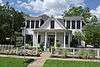 |
October 31, 1988 (#88001948) |
312 E. Broadway 29°05′33″N 97°17′11″W / 29.0925°N 97.286389°W |
Cuero | Recorded Texas Historic Landmark |
| 2 | John Y. Bell House | 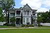 |
October 31, 1988 (#88001982) |
304 E. Prairie 29°05′46″N 97°17′07″W / 29.096111°N 97.285278°W |
Cuero | |
| 3 | M. D. Bennett House | 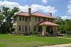 |
October 31, 1988 (#88001963) |
208 N. Hunt 29°05′24″N 97°17′12″W / 29.09°N 97.286667°W |
Cuero | |
| 4 | Billow-Thompson House | 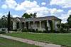 |
October 31, 1988 (#88001949) |
402 E. Broadway 29°05′32″N 97°17′09″W / 29.092222°N 97.285833°W |
Cuero | |
| 5 | Breeden-Runge Wholesale Grocery Company Building | 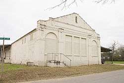 |
October 31, 1988 (#88001957) |
108 N. Frederick William 29°05′32″N 97°17′43″W / 29.092222°N 97.295278°W |
Cuero | |
| 6 | Floyd Buchel House | 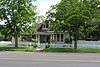 |
October 31, 1988 (#88001950) |
407 E. Broadway 29°05′29″N 97°17′09″W / 29.091389°N 97.285833°W |
Cuero | |
| 7 | Arthur Burns House | 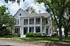 |
October 31, 1988 (#88001987) |
130 E. Sarah 29°05′44″N 97°17′14″W / 29.095556°N 97.287222°W |
Cuero | |
| 8 | John W. Burns House | 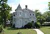 |
October 31, 1988 (#88001947) |
311 E. Broadway 29°05′31″N 97°17′13″W / 29.091944°N 97.286944°W |
Cuero | |
| 9 | Callaway-Gillette House |  |
October 31, 1988 (#88001989) |
306 E. Sarah 29°05′42″N 97°17′07″W / 29.095°N 97.285278°W |
Cuero | |
| 10 | J. B. Chaddock House |  |
October 31, 1988 (#88001995) |
202 S. Valley 29°05′10″N 97°17′06″W / 29.086111°N 97.285°W |
Cuero | |
| 11 | City Water Works | .jpg) |
October 31, 1988 (#88001956) |
208 S. Esplanade 29°05′21″N 97°17′33″W / 29.089167°N 97.2925°W |
Cuero | |
| 12 | Clement-Nagel House |  |
October 31, 1988 (#88001974) |
701 E. Morgan 29°05′07″N 97°17′10″W / 29.085278°N 97.286111°W |
Cuero | |
| 13 | Colston-Gohmert House |  |
October 31, 1988 (#88001983) |
309 E. Prairie 29°05′44″N 97°17′06″W / 29.095556°N 97.285°W |
Cuero | |
| 14 | Charles Cook House | October 31, 1988 (#88001986) |
103 E. Sarah 29°05′44″N 97°17′17″W / 29.095556°N 97.288056°W |
Cuero | Demolished | |
| 15 | W. H. Crain House | 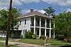 |
October 31, 1988 (#88001953) |
508 E. Courthouse 29°05′25″N 97°17′08″W / 29.09034°N 97.28544°W |
Cuero | |
| 16 | Cuero Commercial Historic District | 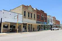 |
November 17, 1988 (#88001996) |
Roughly bounded by Gonzales, Main, Terrell and Courthouse 29°05′28″N 97°17′27″W / 29.091111°N 97.290833°W |
Cuero | Includes Recorded Texas Historic Landmark |
| 17 | Cuero Gin | October 31, 1988 (#88001970) |
501 W. Main 29°05′30″N 97°17′44″W / 29.091667°N 97.295556°W |
Cuero | Demolished by 2005 | |
| 18 | Cuero High School | 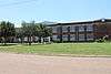 |
October 31, 1988 (#88001990) |
405 E. Sarah 29°05′55″N 97°17′04″W / 29.098611°N 97.284444°W |
Cuero | |
| 19 | Cuero Hydroelectric Plant | September 19, 1977 (#77001514) |
2 mi (3.2 km). N of Cuero on Guadalupe Plant 29°07′46″N 97°18′40″W / 29.129444°N 97.311111°W |
Cuero | ||
| 20 | Cuero I Archeological District |  |
October 9, 1974 (#74002271) |
Address restricted[6] |
Cuero | Extends into Gonzales County |
| 21 | E. A. Daule House | October 31, 1988 (#88001981) |
201 W. Newman 29°05′23″N 97°17′52″W / 29.089722°N 97.297778°W |
Cuero | ||
| 22 | DeWitt County Courthouse | 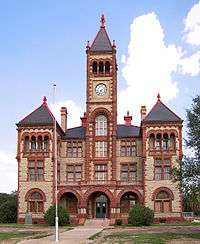 |
May 6, 1971 (#71000929) |
Bounded by N. Gonzales, E. Live Oak, N. Clinton, and E. Courthouse Sts. 29°05′29″N 97°17′19″W / 29.091389°N 97.288611°W |
Cuero | State Antiquities Landmark, Recorded Texas Historic Landmark |
| 23 | East Main Street Residential Historic District | .jpg) |
October 31, 1988 (#88001998) |
400 to 800 blks. of E. Main St. 29°05′16″N 97°17′07″W / 29.087778°N 97.285278°W |
Cuero | |
| 24 | Eckhardt Stores |  |
June 29, 1976 (#76002020) |
Eckhardt and Main St. 28°58′49″N 97°30′13″W / 28.980278°N 97.503611°W |
Yorktown | Recorded Texas Historic Landmark |
| 25 | William and L. F. Eichholz House | .JPG) |
October 31, 1988 (#88001954) |
308 W. Courthouse 29°05′37″N 97°17′39″W / 29.093585°N 97.294073°W |
Cuero | |
| 26 | English-German School |  |
October 31, 1988 (#88001978) |
201 E. Newman 29°05′09″N 97°17′30″W / 29.085833°N 97.291667°W |
Cuero | Recorded Texas Historic Landmark; building is condemned |
| 27 | J. B. Farris House | October 31, 1988 (#88001960) |
502 N. Gonzales 29°05′36″N 97°17′18″W / 29.093333°N 97.288333°W |
Cuero | Demolished | |
| 28 | First Methodist Church | 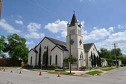 |
October 31, 1988 (#88001952) |
301 E. Courthouse 29°05′27″N 97°17′17″W / 29.090833°N 97.288056°W |
Cuero | |
| 29 | Alfred Friar House |  |
October 31, 1988 (#88001961) |
703 N. Gonzales 29°05′42″N 97°17′13″W / 29.095°N 97.286944°W |
Cuero | |
| 30 | William Frobese Sr. House |  |
October 31, 1988 (#88001980) |
305 E. Newman 29°05′07″N 97°17′24″W / 29.085278°N 97.29°W |
Cuero | Recorded Texas Historic Landmark |
| 31 | Grace Episcopal Church |  |
October 31, 1988 (#88001955) |
401 N. Esplanade 29°05′33″N 97°17′23″W / 29.0925°N 97.289722°W |
Cuero | Recorded Texas Historic Landmark |
| 32 | House at 1002 Stockdale |  |
October 31, 1988 (#88001993) |
1002 Stockdale 29°04′47″N 97°17′37″W / 29.079722°N 97.293611°W |
Cuero | |
| 33 | House at 404 Stockdale |  |
October 31, 1988 (#88001992) |
404 Stockdale 29°05′07″N 97°17′27″W / 29.085278°N 97.290833°W |
Cuero | |
| 34 | House at 609 East Live Oak |  |
October 31, 1988 (#88001968) |
609 E. Live Oak 29°05′24″N 97°17′02″W / 29.09°N 97.283889°W |
Cuero | |
| 35 | Keller-Grunder House |  |
October 31, 1988 (#88001973) |
409 E. Morgan 29°05′11″N 97°17′19″W / 29.086389°N 97.288611°W |
Cuero | Recorded Texas Historic Landmark |
| 36 | Albert and Kate Leinhardt House |  |
October 31, 1988 (#88001976) |
818 E. Morgan 29°05′11″N 97°17′01″W / 29.086389°N 97.283611°W |
Cuero | |
| 37 | Emil Leonardt House | 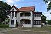 |
November 4, 1988 (#88001975) |
804 E. Morgan 29°05′07″N 97°17′05″W / 29.085278°N 97.284722°W |
Cuero | |
| 38 | Leske Bar | October 31, 1988 (#88001969) |
432 W. Main 29°05′30″N 97°17′41″W / 29.091667°N 97.294722°W |
Cuero | Demolished by 2005, after being damaged in a flood in 1998[7] | |
| 39 | Valentine Ley House |  |
October 31, 1988 (#88001979) |
206 E. Newman 29°05′10″N 97°17′30″W / 29.086111°N 97.291667°W |
Cuero | |
| 40 | Lynch-Probst House | October 31, 1988 (#88001951) |
502 E. Broadway 29°05′31″N 97°17′06″W / 29.091944°N 97.285°W |
Cuero | Demolished | |
| 41 | Macedonia Baptist Church |  |
October 31, 1988 (#88001967) |
512 S. Indianola 29°05′12″N 97°17′54″W / 29.086667°N 97.298333°W |
Cuero | |
| 42 | Frank Marie House |  |
October 31, 1988 (#88001959) |
402 E. French 29°05′36″N 97°17′07″W / 29.093333°N 97.285278°W |
Cuero | |
| 43 | May-Hickey House | October 27, 1988 (#88002129) |
FM 682 1.7 mi. S of jct. with TX 111 29°15′39″N 97°08′40″W / 29.260833°N 97.144444°W |
Yoakum | Recorded Texas Historic Landmark | |
| 44 | Meissner-Pleasants House |  |
October 31, 1988 (#88001962) |
108 N. Hunt 29°05′21″N 97°17′12″W / 29.089167°N 97.286667°W |
Cuero | |
| 45 | Edward Mugge House |  |
October 31, 1988 (#88001994) |
218 N. Terrell 29°05′30″N 97°17′33″W / 29.091667°N 97.2925°W |
Cuero | Recorded Texas Historic Landmark |
| 46 | Municipal Power Plant | 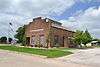 |
November 15, 1996 (#96001356) |
810 Front St. 29°17′08″N 97°09′04″W / 29.285556°N 97.151111°W |
Yoakum | Recorded Texas Historic Landmark; now the city library |
| 47 | Old Beer and Ice Warehouse | 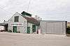 |
October 31, 1988 (#88001985) |
104 SW Railroad 29°05′23″N 97°17′33″W / 29.089754°N 97.292525°W |
Cuero | |
| 48 | Charles J. and Alvina Ott House | 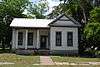 |
October 31, 1988 (#88001965) |
306 N. Hunt 29°05′27″N 97°17′10″W / 29.090833°N 97.286111°W |
Cuero | |
| 49 | S. I. Ott House | 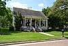 |
October 31, 1988 (#88001964) |
302 N. Hunt 29°05′26″N 97°17′11″W / 29.090556°N 97.286389°W |
Cuero | |
| 50 | O. F. and Mary Prigden House |  |
October 31, 1988 (#88001958) |
401 E. French 29°05′34″N 97°17′08″W / 29.092778°N 97.285556°W |
Cuero | |
| 51 | J. M. Reuss House |  |
October 31, 1988 (#88001991) |
315 Stockdale 29°05′09″N 97°17′24″W / 29.085833°N 97.29°W |
Cuero | |
| 52 | St. Michael's Catholic Church |  |
October 31, 1988 (#88001971) |
202 N. McLeod 29°05′24″N 97°17′15″W / 29.09°N 97.2875°W |
Cuero | |
| 53 | State Highway 27 Bridge at the Guadalupe River |  |
October 10, 1996 (#96001122) |
US 87, .13 mi. S of jct. with US 183 29°03′55″N 97°19′20″W / 29.065278°N 97.322222°W |
Cuero | |
| 54 | Elisha Stevens House |  |
October 31, 1988 (#88001984) |
408 E. Prairie 29°05′44″N 97°17′02″W / 29.095556°N 97.283889°W |
Cuero | |
| 55 | Terrell-Reuss Streets Historic District |  |
October 31, 1988 (#88001997) |
300 to 900 blks. of Terrell, 500 to 900 blks. of Indianola, and 200 blk. of W. Reuss to 400 blk. of E. Reuss 29°05′44″N 97°17′18″W / 29.095556°N 97.288333°W |
Cuero | Includes Recorded Texas Historic Landmarks |
| 56 | W. F. Thomson House |  |
October 31, 1988 (#88001972) |
608 N. McLeod 29°05′37″N 97°17′08″W / 29.093611°N 97.285556°W |
Cuero | |
| 57 | Dane Wittenbert House |  |
October 31, 1988 (#88001966) |
402 S. Hunt 29°05′05″N 97°17′20″W / 29.084722°N 97.288889°W |
Cuero | |
| 58 | Charles Wittmer House |  |
October 31, 1988 (#88001977) |
110 E. Newman 29°05′11″N 97°17′33″W / 29.086389°N 97.2925°W |
Cuero | |
| 59 | Wofford-Finney House |  |
August 14, 1992 (#92000984) |
202 E. Prairie St. 29°05′48″N 97°17′11″W / 29.096667°N 97.286389°W |
Cuero |
See also
References
- ↑ "National Register of Historic Places: Weekly List Actions". National Park Service, United States Department of the Interior. Retrieved on October 11, 2018.
- ↑ The latitude and longitude information provided in this table was derived originally from the National Register Information System, which has been found to be fairly accurate for about 99% of listings. For about 1% of NRIS original coordinates, experience has shown that one or both coordinates are typos or otherwise extremely far off; some corrections may have been made. A more subtle problem causes many locations to be off by up to 150 yards, depending on location in the country: most NRIS coordinates were derived from tracing out latitude and longitudes from USGS topographical quadrant maps created under the North American Datum of 1927, which differs from the current, highly accurate WGS84 GPS system used by most on-line maps. Chicago is about right, but NRIS longitudes in Washington are higher by about 4.5 seconds, and are lower by about 2.0 seconds in Maine. Latitudes differ by about 1.0 second in Florida. Some locations in this table may have been corrected to current GPS standards.
- ↑ Numbers represent an ordering by significant words. Various colorings, defined here, differentiate National Historic Landmarks and historic districts from other NRHP buildings, structures, sites or objects.
- ↑ National Park Service (2010-07-09). "National Register Information System". National Register of Historic Places. National Park Service.
- ↑ The eight-digit number below each date is the number assigned to each location in the National Register Information System database, which can be viewed by clicking the number.
- ↑ Federal and state laws and practices restrict general public access to information regarding the specific location of this resource. In some cases, this is to protect archeological sites from vandalism, while in other cases it is restricted at the request of the owner. See: Knoerl, John; Miller, Diane; Shrimpton, Rebecca H. (1990), Guidelines for Restricting Information about Historic and Prehistoric Resources, National Register Bulletin (29), National Park Service, U.S. Department of the Interior, OCLC 20706997 .
- ↑ Victoria Advocate
External links
![]()
Places adjacent to National Register of Historic Places listings in DeWitt County, Texas | ||||||||||
|---|---|---|---|---|---|---|---|---|---|---|
| ||||||||||


Municipalities and communities of DeWitt County, Texas, United States | ||
|---|---|---|
| Cities | 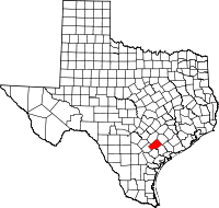 | |
| Unincorporated communities | ||
| Ghost towns | ||
| Footnotes | ‡This populated place also has portions in an adjacent county or counties | |