National Register of Historic Places listings in Erath County, Texas
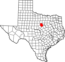
Location of Erath County in Texas
This is a list of the National Register of Historic Places listings in Erath County, Texas.
This is intended to be a complete list of properties and districts listed on the National Register of Historic Places in Erath County, Texas. There are one district and five individual properties listed on the National Register in the county. Four properties are also Recorded Texas Historic Landmarks including one State Antiquities Landmark.
- This National Park Service list is complete through NPS recent listings posted October 11, 2018.[1]
Current listings
The locations of National Register properties and districts may be seen in a mapping service provided.[2]
| [3] | Name on the Register | Image | Date listed[4] | Location | City or town | Description |
|---|---|---|---|---|---|---|
| 1 | Berry House | .jpg) |
May 15, 1980 (#80004116) |
525 E. Washington St. 32°13′19″N 98°11′57″W / 32.221944°N 98.199167°W |
Stephenville | Recorded Texas Historic Landmark |
| 2 | Bluff Dale Bridge | 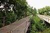 |
December 20, 1977 (#77001440) |
County Road 149 (Berry's Creek Rd.) at the Paluxy River 32°21′14″N 98°01′34″W / 32.353889°N 98.026111°W |
Bluff Dale | |
| 3 | Erath County Courthouse | .jpg) |
August 18, 1977 (#77001441) |
Public Sq. 32°13′12″N 98°12′07″W / 32.22°N 98.201944°W |
Stephenville | State Antiquities Landmark, Recorded Texas Historic Landmark |
| 4 | Erath Memorial Arch | 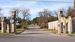 |
April 19, 2018 (#100002348) |
N Erath Ave. & W Washington St. 32°13′08″N 98°12′21″W / 32.218943°N 98.205836°W |
Stephenville | |
| 5 | First National Bank Building | .jpg) |
July 21, 2015 (#15000450) |
198 S. Belknap St. 32°13′11″N 98°12′10″W / 32.219671°N 98.202697°W |
Stephenville | Recorded Texas Historic Landmark |
| 6 | Stephenville Downtown Historic District | .jpg) |
April 23, 2018 (#10002349) |
Roughly bounded by McNeil, & Tarleton Sts., Barton & Devine Aves. 32°13′14″N 98°12′10″W / 32.220581°N 98.202670°W |
Stephenville | |
| 7 | Thurber Historic District | .jpg) |
August 17, 1979 (#79002936) |
South of Thurber 32°29′57″N 98°25′54″W / 32.499167°N 98.431667°W |
Thurber | |
| 8 | Wyatt-Hickie Ranch Complex | December 26, 1985 (#85003162) |
Off US 281 northwest of FM 913 32°08′39″N 98°09′08″W / 32.144167°N 98.152222°W |
Stephenville | Recorded Texas Historic Landmark |
See also
References
- ↑ "National Register of Historic Places: Weekly List Actions". National Park Service, United States Department of the Interior. Retrieved on October 11, 2018.
- ↑ The latitude and longitude information provided in this table was derived originally from the National Register Information System, which has been found to be fairly accurate for about 99% of listings. For about 1% of NRIS original coordinates, experience has shown that one or both coordinates are typos or otherwise extremely far off; some corrections may have been made. A more subtle problem causes many locations to be off by up to 150 yards, depending on location in the country: most NRIS coordinates were derived from tracing out latitude and longitudes from USGS topographical quadrant maps created under the North American Datum of 1927, which differs from the current, highly accurate WGS84 GPS system used by most on-line maps. Chicago is about right, but NRIS longitudes in Washington are higher by about 4.5 seconds, and are lower by about 2.0 seconds in Maine. Latitudes differ by about 1.0 second in Florida. Some locations in this table may have been corrected to current GPS standards.
- ↑ Numbers represent an ordering by significant words. Various colorings, defined here, differentiate National Historic Landmarks and historic districts from other NRHP buildings, structures, sites or objects.
- ↑ The eight-digit number below each date is the number assigned to each location in the National Register Information System database, which can be viewed by clicking the number.
External links
![]()


Municipalities and communities of Erath County, Texas, United States | ||
|---|---|---|
| Cities | | |
| Unincorporated communities | ||
| Ghost Town | ||
This article is issued from
Wikipedia.
The text is licensed under Creative Commons - Attribution - Sharealike.
Additional terms may apply for the media files.