National Register of Historic Places listings in El Paso County, Texas
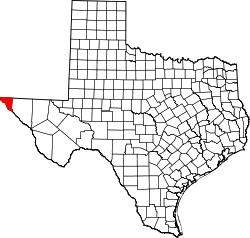
Location of El Paso County in Texas
This is a list of the National Register of Historic Places listings in El Paso County, Texas.
This is intended to be a complete list of properties and districts listed on the National Register of Historic Places in El Paso County, Texas. There are 12 districts, one National Historic Landmark, 43 individual properties, and one former property listed on the National Register in the county. Two of these sites are State Historic Sites. Nine sites are also listed as Recorded Texas Historic Landmarks including three that are State Antiquities Landmarks.
- This National Park Service list is complete through NPS recent listings posted October 11, 2018.[1]
Current listings
The publicly disclosed locations of National Register properties and districts may be seen in a mapping service provided.[2]
| [3] | Name on the Register[4] | Image | Date listed[5] | Location | City or town | Description |
|---|---|---|---|---|---|---|
| 1 | Abdou Building | 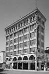 |
September 24, 1980 (#80004100) |
115 N. Mesa St. 31°45′30″N 106°29′13″W / 31.758333°N 106.486944°W |
El Paso | Commercial Structures of El Paso by Henry C. Trost Thematic Resources |
| 2 | O. T. Bassett Tower | 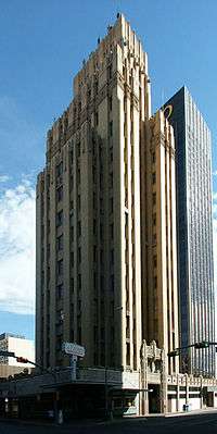 |
September 24, 1980 (#80004101) |
301 Texas Ave. 31°45′35″N 106°29′11″W / 31.759722°N 106.486389°W |
El Paso | Commercial Structures of El Paso by Henry C. Trost Thematic Resources |
| 3 | Richard Caples Building | 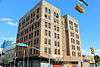 |
September 24, 1980 (#80004102) |
300 E. San Antonio Ave. 31°45′29″N 106°29′12″W / 31.758056°N 106.486667°W |
El Paso | Commercial Structures of El Paso by Henry C. Trost Thematic Resources |
| 4 | Castner Range Archeological District |  |
April 22, 1976 (#76002021) |
Address restricted[6] |
El Paso | |
| 5 | Chamizal National Memorial | 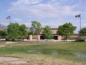 |
February 4, 1974 (#74002069) |
Paisano Dr. 31°45′35″N 106°29′58″W / 31.759722°N 106.499444°W |
El Paso | |
| 6 | Sgt. Doyle Site |  |
April 11, 1977 (#77001439) |
Address restricted[6] |
El Paso | |
| 7 | El Paso County Water Improvement District No. 1 | August 25, 1997 (#97000885) |
Starting at the jct. of US 80 and US 85, along TX 20 to Alamo Alto 31°33′58″N 106°14′18″W / 31.566111°N 106.238333°W |
El Paso | ||
| 8 | El Paso High School | 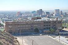 |
November 17, 1980 (#80004103) |
1600 N. Virginia St. 31°46′21″N 106°29′23″W / 31.7725°N 106.489722°W |
El Paso | Recorded Texas Historic Landmark |
| 9 | El Paso Natural Gas Company (Blue Flame) Building | February 13, 2018 (#100002129) |
120 N Stanton 31°45′33″N 106°29′10″W / 31.759221°N 106.486142°W |
El Paso | ||
| 10 | El Paso Union Passenger Station | 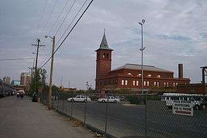 |
April 3, 1975 (#75001970) |
SW corner of Coldwell at San Francisco St. 31°45′26″N 106°29′45″W / 31.757222°N 106.495833°W |
El Paso | Recorded Texas Historic Landmark |
| 11 | El Paso US Courthouse | 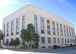 |
April 25, 2001 (#01000434) |
511 W. San Antonio Ave. 31°45′33″N 106°29′00″W / 31.759167°N 106.483333°W |
El Paso | |
| 12 | Elephant Butte Irrigation District | August 8, 1997 (#97000822) |
Roughly along U.S. Route 85 between its junction with New Mexico State Road 90 and the El Paso city limits 32°12′58″N 106°57′31″W / 32.216111°N 106.958611°W |
Las Cruces | Extends into Doña Ana County, New Mexico and Sierra County, New Mexico | |
| 13 | First Mortgage Company Building | 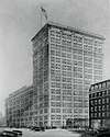 |
June 13, 1978 (#78002925) |
109 N. Oregon St. 31°45′29″N 106°29′17″W / 31.758056°N 106.488056°W |
El Paso | |
| 14 | Fort Bliss Main Post Historic District | 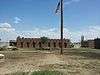 |
May 7, 1998 (#98000427) |
Fort Bliss 31°48′26″N 106°25′56″W / 31.807222°N 106.432222°W |
El Paso | |
| 15 | Fort Bliss National Cemetery | 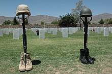 |
March 8, 2016 (#16000066) |
5200 Fred Wilson Boulevard 31°49′22″N 106°25′25″W / 31.8229°N 106.4236°W |
El Paso | |
| 16 | Franklin Canal | 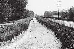 |
June 19, 1992 (#92000696) |
Roughly, S of the Texas and Pacific-Southern Pacific RR tracks from western El Paso to Fabens 31°40′21″N 106°22′35″W / 31.6725°N 106.376389°W |
El Paso | |
| 17 | Fusselman Canyon Rock Art District |  |
June 3, 1976 (#76002022) |
Address restricted[6] |
El Paso | |
| 18 | W. S. Hills Commercial Structure | September 24, 1980 (#80004104) |
215-219 San Antonio Ave. 31°45′29″N 106°29′13″W / 31.758056°N 106.486944°W |
El Paso | ||
| 19 | Hot Well Archeological Site |  |
April 30, 1976 (#76002023) |
Address restricted[6] |
El Paso | |
| 20 | Hotel Cortez | 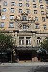 |
September 24, 1980 (#80004105) |
300 N. Mesa St. 31°45′35″N 106°29′14″W / 31.759722°N 106.487222°W |
El Paso | Commercial Structures of El Paso by Henry C. Trost Thematic Resources, Recorded Texas Historic Landmark |
| 21 | Hotel Paso del Norte | 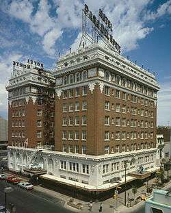 |
January 5, 1979 (#79002933) |
115 El Paso St. 31°53′20″N 106°34′15″W / 31.888889°N 106.570833°W |
El Paso | Commercial Structures of El Paso by Henry C. Trost Thematic Resources |
| 22 | House at 912 Magoffin Avenue | 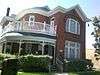 |
June 23, 2003 (#03000557) |
912 Magoffin Ave 31°45′41″N 106°28′43″W / 31.761389°N 106.478611°W |
El Paso | |
| 23 | Hueco Tanks | 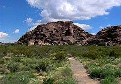 |
July 14, 1971 (#71000930) |
Address restricted[6] |
El Paso | State Historic Site (TPWD) |
| 24 | Magoffin Historic District | October 11, 2016 (#16000717) |
Roughly bounded by San Antonio, Virginia, Myrtle, and Cotton Sts. 31°45′45″N 106°28′36″W / 31.7625°N 106.476667°W |
El Paso | 179 contributing buildings. | |
| 25 | Magoffin Homestead | 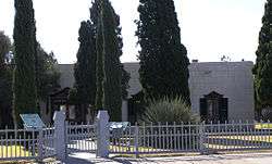 |
March 31, 1971 (#71000931) |
1120 Magoffin Ave. 31°45′45″N 106°28′36″W / 31.7625°N 106.476667°W |
El Paso | State Historic Site (THC); State Antiquities Landmark; Recorded Texas Historic Landmark |
| 26 | Manhattan Heights Historic District |  |
September 27, 1980 (#80004107) |
Roughly bounded by Grant, Louisiana and Richmond Aves. 31°47′26″N 106°27′32″W / 31.790556°N 106.458889°W |
El Paso | |
| 27 | Martin Building | 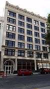 |
August 8, 1984 (#84001655) |
215 N. Stanton St. 31°45′35″N 106°29′11″W / 31.759722°N 106.486389°W |
El Paso | Recorded Texas Historic Landmark |
| 28 | Mesa Pump Plant | June 19, 2009 (#09000450) |
4901 Fred Wilson Avenue 31°49′35″N 106°25′43″W / 31.826389°N 106.42875°W |
El Paso | Recorded Texas Historic Landmark | |
| 29 | Mills Building | 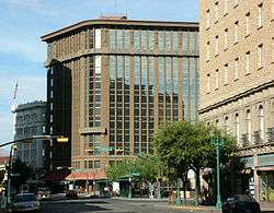 |
March 21, 2011 (#11000130) |
303 N. Oregon St. 31°45′33″N 106°29′21″W / 31.759097°N 106.489097°W |
El Paso | Described, but not included in Commercial Structures of El Paso by Henry C. Trost Thematic Resources due to alterations |
| 30 | Mission Socorro Archeological Site | |
January 22, 1993 (#92001741) |
Address restricted[6] |
Socorro | |
| 31 | Montana Avenue Historic District | 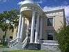 |
November 13, 2004 (#04001232) |
1000 through 1500 Blks of Montana Ave. 31°46′21″N 106°28′52″W / 31.7725°N 106.481111°W |
El Paso | |
| 32 | J. J. Newberry Company |  |
September 24, 1980 (#80004108) |
201-205 N. Stanton St. 31°45′33″N 106°29′10″W / 31.759167°N 106.486111°W |
El Paso | Commercial Structures of El Paso by Henry C. Trost Thematic Resources |
| 33 | Northgate Site | |
March 16, 1972 (#72001356) |
Address restricted[6] |
El Paso | |
| 34 | Old Bnai Zion Synagogue |  |
August 16, 1984 (#84001658) |
906 N. El Paso St. 31°45′37″N 106°29′22″W / 31.760278°N 106.489444°W |
El Paso | State Antiquities Landmark; Recorded Texas Historic Landmark |
| 35 | Old Fort Bliss |  |
February 23, 1972 (#72001357) |
1800 block of Doniphan St. 31°45′47″N 106°30′33″W / 31.763056°N 106.509167°W |
El Paso | Recorded Texas Historic Landmark |
| 36 | Old San Francisco Historic District |  |
May 21, 1985 (#85001132) |
Missouri St. between No. 325 and 527 31°45′33″N 106°29′39″W / 31.759167°N 106.494167°W |
El Paso | |
| 37 | Palace Theatre | 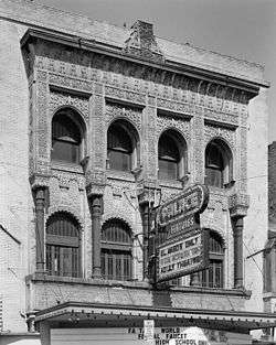 |
September 24, 1980 (#80004109) |
209 S. El Paso St. 31°45′25″N 106°29′19″W / 31.756944°N 106.488611°W |
El Paso | Alhambra Theatre, Commercial Structures of El Paso by Henry C. Trost Thematic Resources |
| 38 | Plaza Hotel | 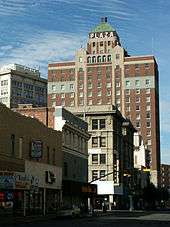 |
September 24, 1980 (#80004110) |
Oregon and Mills Sts. 31°45′31″N 106°29′18″W / 31.758611°N 106.488333°W |
El Paso | Commercial Structures of El Paso by Henry C. Trost Thematic Resources |
| 39 | Plaza Theatre | 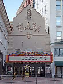 |
June 4, 1987 (#87000902) |
125 Pioneer Plaza 31°45′31″N 106°29′11″W / 31.758611°N 106.486389°W |
El Paso | |
| 40 | Popular Department Store | 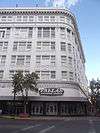 |
September 24, 1980 (#80004111) |
102 N. Mesa St. 31°45′30″N 106°29′10″W / 31.758333°N 106.486111°W |
El Paso | Commercial Structures of El Paso by Henry C. Trost Thematic Resources |
| 41 | Presidio Chapel of San Elizario | 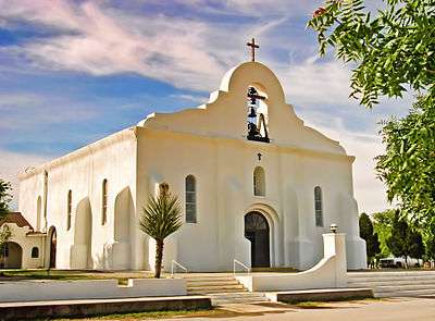 |
September 14, 1972 (#72001358) |
S side of plaza 31°35′05″N 106°16′22″W / 31.584722°N 106.272778°W |
San Elizario | Recorded Texas Historic Landmark |
| 42 | Quarters Number 1 | 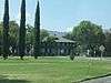 |
April 9, 1987 (#87000484) |
228 Sheridan Rd. 31°48′29″N 106°26′15″W / 31.808056°N 106.4375°W |
Fort Bliss | |
| 43 | Rio Grande Avenue Historic District | September 9, 1999 (#99001140) |
Roughly bounded by Rio Grande, Navada, Kansas, and Campbell Sts. 31°46′10″N 106°29′14″W / 31.769444°N 106.487222°W |
El Paso | ||
| 44 | Rio Vista Farm Historic District |  |
February 22, 1996 (#96000131) |
800-801 Rio Vista Rd. 31°39′41″N 106°15′52″W / 31.661389°N 106.264444°W |
Socorro | |
| 45 | Roberts-Banner Building | 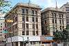 |
September 24, 1980 (#80004112) |
215 N. Mesa St. 31°45′32″N 106°29′14″W / 31.758889°N 106.487222°W |
El Paso | Commercial Structures of El Paso by Henry C. Trost Thematic Resources |
| 46 | San Elizario Historic District | _fa%C3%A7ade_and_west_fa%C3%A7ade_-_Old_County_Jail%2C_San_Elizario_Plaza%2C_El_Paso%2C_El_Paso_County%2C_TX_HABS_TEX%2C71-ELPA%2C2-1.tif.jpg) |
February 27, 1997 (#97000205) |
Roughly bounded by Rio Grande St., Socorro and Convent Rds., and the San Elizario Lateral 31°35′07″N 106°16′21″W / 31.585278°N 106.2725°W |
San Elizario | |
| 47 | Silver Dollar Cafe |  |
August 14, 1986 (#86002618) |
1021 S. Mesa 31°44′58″N 106°29′02″W / 31.749444°N 106.483889°W |
El Paso | |
| 48 | Singer Sewing Company | September 24, 1980 (#80004113) |
211 Texas Ave. 31°45′33″N 106°29′12″W / 31.759167°N 106.486667°W |
El Paso | Commercial Structures of El Paso by Henry C. Trost Thematic Resources, Recorded Texas Historic Landmark | |
| 49 | Socorro Mission | 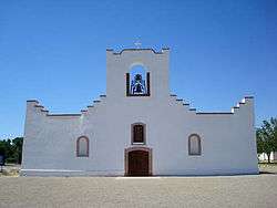 |
March 16, 1972 (#72001359) |
Moon Rd. and TX 258 31°39′30″N 106°18′09″W / 31.658333°N 106.3025°W |
Socorro | State Antiquities Landmark; Recorded Texas Historic Landmark |
| 50 | State National Bank | 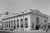 |
September 24, 1980 (#80004114) |
114 E. San Antonio Ave. 31°45′27″N 106°29′15″W / 31.7575°N 106.4875°W |
El Paso | Commercial Structures of El Paso by Henry C. Trost Thematic Resources |
| 51 | Sunset Heights Historic District |  |
December 8, 1988 (#88002672) |
Roughly bounded by Heisig Ave., River Ave., N. El Paso St., and I-10 31°45′47″N 106°29′53″W / 31.763056°N 106.498056°W |
El Paso | |
| 52 | Toltec Club | 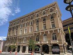 |
March 12, 1979 (#79002934) |
602 Magoffin Ave. 31°45′33″N 106°28′56″W / 31.75906°N 106.482109°W |
El Paso | |
| 53 | Henry C. Trost House | 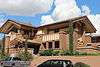 |
July 12, 1976 (#76002024) |
1013 W. Yandell Dr. 31°45′52″N 106°29′58″W / 31.764444°N 106.499444°W |
El Paso | |
| 54 | U.S. Post Office | 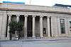 |
July 19, 1984 (#84001662) |
219 Mills Ave. 31°45′36″N 106°29′13″W / 31.76°N 106.486944°W |
El Paso | |
| 55 | White House Department Store and Hotel McCoy | 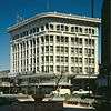 |
September 24, 1980 (#80004115) |
109 Pioneer Plaza 31°45′32″N 106°29′19″W / 31.758889°N 106.488611°W |
El Paso | Commercial Structures of El Paso by Henry C. Trost Thematic Resources |
| 56 | Women's Club |  |
July 22, 1979 (#79002935) |
1400 N. Mesa St. 31°46′02″N 106°29′40″W / 31.767222°N 106.494444°W |
El Paso | Recorded Texas Historic Landmark |
| 57 | Ysleta Mission | 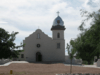 |
July 31, 1972 (#72001360) |
TX 20 near jct. with Zaragosa Rd. 31°41′27″N 106°19′38″W / 31.690833°N 106.327222°W |
Ysleta | Recorded Texas Historic Landmark |
Former listings
| [3] | Name on the Register | Image | Date listed | Date removed | Location | City or town | Summary |
|---|---|---|---|---|---|---|---|
| 1 | 1800's Mexican Consulate | May 23, 1975 (#75001969) | December 3, 2013 | 612 E. San Antonio St. 31°45′33″N 106°28′58″W / 31.759167°N 106.482778°W |
El Paso |
See also
References
- ↑ "National Register of Historic Places: Weekly List Actions". National Park Service, United States Department of the Interior. Retrieved on October 11, 2018.
- ↑ The latitude and longitude information provided in this table was derived originally from the National Register Information System, which has been found to be fairly accurate for about 99% of listings. For about 1% of NRIS original coordinates, experience has shown that one or both coordinates are typos or otherwise extremely far off; some corrections may have been made. A more subtle problem causes many locations to be off by up to 150 yards, depending on location in the country: most NRIS coordinates were derived from tracing out latitude and longitudes from USGS topographical quadrant maps created under the North American Datum of 1927, which differs from the current, highly accurate WGS84 GPS system used by most on-line maps. Chicago is about right, but NRIS longitudes in Washington are higher by about 4.5 seconds, and are lower by about 2.0 seconds in Maine. Latitudes differ by about 1.0 second in Florida. Some locations in this table may have been corrected to current GPS standards.
- 1 2 Numbers represent an ordering by significant words. Various colorings, defined here, differentiate National Historic Landmarks and historic districts from other NRHP buildings, structures, sites or objects.
- ↑ National Park Service (2008-04-24). "National Register Information System". National Register of Historic Places. National Park Service.
- ↑ The eight-digit number below each date is the number assigned to each location in the National Register Information System database, which can be viewed by clicking the number.
- 1 2 3 4 5 6 7 Federal and state laws and practices restrict general public access to information regarding the specific location of this resource. In some cases, this is to protect archeological sites from vandalism, while in other cases it is restricted at the request of the owner. See: Knoerl, John; Miller, Diane; Shrimpton, Rebecca H. (1990), Guidelines for Restricting Information about Historic and Prehistoric Resources, National Register Bulletin (29), National Park Service, U.S. Department of the Interior, OCLC 20706997 .
External links
| Wikimedia Commons has media related to National Register of Historic Places in El Paso County, Texas. |
- Historical Markers Project, El Paso Community College Survey of thirty-three historic sites in the El Paso area, with research materials, interviews, and summary materials


Municipalities and communities of El Paso County, Texas, United States | ||
|---|---|---|
| Cities | | |
| Towns | ||
| Village | ||
| CDPs | ||
| Unincorporated communities | ||
| Indian reservation | ||
This article is issued from
Wikipedia.
The text is licensed under Creative Commons - Attribution - Sharealike.
Additional terms may apply for the media files.