National Register of Historic Places listings in Hunt County, Texas
Location of Hunt County in Texas
This is a list of the National Register of Historic Places listings in Hunt County, Texas.
This is intended to be a complete list of properties and districts listed on the National Register of Historic Places in Hunt County, Texas. There are seven properties listed on the National Register in the county. Four of these are also designated Recorded Texas Historic Landmarks.
- This National Park Service list is complete through NPS recent listings posted October 11, 2018.[1]
Current listings
The locations of National Register properties may be seen in a mapping service provided.[2]
| [3] | Name on the Register | Image | Date listed[4] | Location | City or town | Description |
|---|---|---|---|---|---|---|
| 1 | William and Medora Camp House | 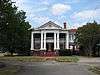 |
November 14, 1988 (#88002130) |
2620 Church St. 33°08′34″N 96°06′27″W / 33.142778°N 96.1075°W |
Greenville | Recorded Texas Historic Landmark |
| 2 | Central Christian Church | .jpg) |
January 6, 2004 (#03001376) |
2611 Wesley St. 33°08′19″N 96°06′30″W / 33.138611°N 96.108333°W |
Greenville | Recorded Texas Historic Landmark |
| 3 | Hunt County Courthouse | 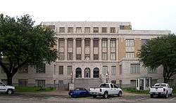 |
June 21, 1996 (#96000688) |
2500 Lee St. 33°08′22″N 96°06′23″W / 33.139444°N 96.106389°W |
Greenville | Recorded Texas Historic Landmark |
| 4 | Katy Depot | 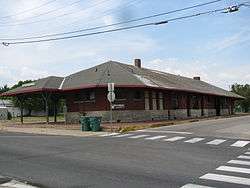 |
January 25, 1997 (#96001625) |
3102 Lee St. 33°08′25″N 96°06′44″W / 33.140278°N 96.112222°W |
Greenville | |
| 5 | Post Office Building | 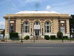 |
August 7, 1974 (#74002081) |
Lee at King St. 33°08′24″N 96°06′39″W / 33.14°N 96.110833°W |
Greenville | |
| 6 | President's House | .jpg) |
November 21, 2001 (#01001264) |
SW of Circle Dr., N of Stonewall St., bet. Campbell and Bois D'Arc Sts. 33°14′33″N 95°54′18″W / 33.2425°N 95.905°W |
Commerce | Recorded Texas Historic Landmark |
| 7 | Washington Hotel | .jpg) |
November 27, 2010 (#10000962) |
2612 Washington Street 33°08′21″N 96°06′28″W / 33.139236°N 96.107847°W |
Greenville |
Former listings
| [3] | Name on the Register | Image | Date listed | Date removed | Location | City or town | Summary |
|---|---|---|---|---|---|---|---|
| 1 | Blanton School | September 12, 2006 (#06000823) | June 3, 2009 | 610 E Witt St. 33°22′07″N 96°04′03″W / 33.3686°N 96.0675°W |
Wolfe City | Torn down August 7, 2008.[5] | |
| 2 | Mayo Hall | .jpg) |
July 31, 2003 (#03000727) | October 12, 2010 | Monroe and Stonewall Sts. 33°14′33″N 95°54′12″W / 33.2425°N 95.9033°W |
Commerce | Delisted after being torn down. |
See also
References
- ↑ "National Register of Historic Places: Weekly List Actions". National Park Service, United States Department of the Interior. Retrieved on October 11, 2018.
- ↑ The latitude and longitude information provided in this table was derived originally from the National Register Information System, which has been found to be fairly accurate for about 99% of listings. For about 1% of NRIS original coordinates, experience has shown that one or both coordinates are typos or otherwise extremely far off; some corrections may have been made. A more subtle problem causes many locations to be off by up to 150 yards, depending on location in the country: most NRIS coordinates were derived from tracing out latitude and longitudes from USGS topographical quadrant maps created under the North American Datum of 1927, which differs from the current, highly accurate WGS84 GPS system used by most on-line maps. Chicago is about right, but NRIS longitudes in Washington are higher by about 4.5 seconds, and are lower by about 2.0 seconds in Maine. Latitudes differ by about 1.0 second in Florida. Some locations in this table may have been corrected to current GPS standards.
- 1 2 Numbers represent an ordering by significant words. Various colorings, defined here, differentiate National Historic Landmarks and historic districts from other NRHP buildings, structures, sites or objects.
- ↑ The eight-digit number below each date is the number assigned to each location in the National Register Information System database, which can be viewed by clicking the number.
- ↑ http://www.telehobbies.com/PGR/WC,%20PAGE%201,%208-14-2008.pdf
External links
![]()


Municipalities and communities of Hunt County, Texas, United States | ||
|---|---|---|
| Cities | | |
| Town | ||
| Unincorporated communities | ||
| Footnotes | ‡This populated place also has portions in an adjacent county or counties | |
This article is issued from
Wikipedia.
The text is licensed under Creative Commons - Attribution - Sharealike.
Additional terms may apply for the media files.