National Register of Historic Places listings in Uvalde County, Texas
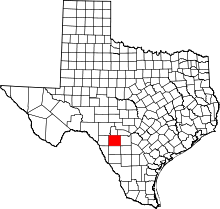
Location of Uvalde County in Texas
This is a list of the National Register of Historic Places listings in Uvalde County, Texas.
This is intended to be a complete list of properties listed on the National Register of Historic Places in Uvalde County, Texas. There are ten properties listed on the National Register in the county including one National Historic Landmark (NHL). The NHL site is also a State Antiquities Landmark and a Recorded Texas Historic Landmark (RTHL) while two additional properties are also RTHLs.
- This National Park Service list is complete through NPS recent listings posted October 11, 2018.[1]
Current listings
The publicly disclosed locations of National Register properties may be seen in a mapping service provided.[2]
| [3] | Name on the Register | Image | Date listed[4] | Location | City or town | Description |
|---|---|---|---|---|---|---|
| 1 | First National Bank | 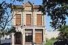 |
March 31, 2014 (#14000106) |
100 S. East St. 29°12′35″N 99°47′07″W / 29.209717°N 99.785183°W |
Uvalde | |
| 2 | Fort Inge Archeological Site | 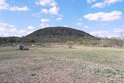 |
September 12, 1985 (#85002298) |
Southeast of Uvalde off Ranch Road 140 29°10′45″N 99°45′57″W / 29.179167°N 99.765833°W |
Uvalde | Remnants of a frontier fort established in 1849. Now a county park. |
| 3 | John Nance Garner House | 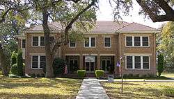 |
December 8, 1976 (#76002074) |
333 N. Park St. 29°12′45″N 99°47′33″W / 29.212569°N 99.792431°W |
Uvalde | State Antiquities Landmark, Recorded Texas Historic Landmark; former home of John Nance Garner, 32nd Vice-President of the United States. Now a museum about his life and times. |
| 4 | Grand Opera House | 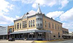 |
May 22, 1978 (#78002996) |
E. North and N. Getty Sts. 29°12′37″N 99°47′12″W / 29.210278°N 99.786667°W |
Uvalde | Recorded Texas Historic Landmark; built in 1891 for plays, musicals, and cultural performances. It still serves the same function today making it the oldest functioning theater in the state of Texas. |
| 5 | Leona River Archeological Site |  |
May 6, 1976 (#76002075) |
Address restricted[5] |
Uvalde | |
| 6 | Nicolas Street School | 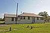 |
November 27, 2010 (#10000963) |
332 Nicolas Street 29°12′08″N 99°47′35″W / 29.202222°N 99.793056°W |
Uvalde | Recorded Texas Historic Landmark |
| 7 | State Highway 3 Bridge at the Nueces River | 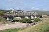 |
October 10, 1996 (#96001108) |
US 90, 13 mi (21 km). E of jct. with Kinney Cnty. 29°12′20″N 99°54′07″W / 29.205556°N 99.901944°W |
Uvalde | |
| 8 | Taylor Slough Archeological Site | |
May 4, 1976 (#76002076) |
Address restricted[5] |
Uvalde | |
| 9 | Uvalde Flint Quarry | |
June 3, 1976 (#76002077) |
Address restricted[5] |
Uvalde | |
| 10 | Willingham Site | |
April 26, 1976 (#76002078) |
Address restricted[5] |
Uvalde |
See also
References
- ↑ "National Register of Historic Places: Weekly List Actions". National Park Service, United States Department of the Interior. Retrieved on October 11, 2018.
- ↑ The latitude and longitude information provided in this table was derived originally from the National Register Information System, which has been found to be fairly accurate for about 99% of listings. For about 1% of NRIS original coordinates, experience has shown that one or both coordinates are typos or otherwise extremely far off; some corrections may have been made. A more subtle problem causes many locations to be off by up to 150 yards, depending on location in the country: most NRIS coordinates were derived from tracing out latitude and longitudes from USGS topographical quadrant maps created under the North American Datum of 1927, which differs from the current, highly accurate WGS84 GPS system used by most on-line maps. Chicago is about right, but NRIS longitudes in Washington are higher by about 4.5 seconds, and are lower by about 2.0 seconds in Maine. Latitudes differ by about 1.0 second in Florida. Some locations in this table may have been corrected to current GPS standards.
- ↑ Numbers represent an ordering by significant words. Various colorings, defined here, differentiate National Historic Landmarks and historic districts from other NRHP buildings, structures, sites or objects.
- ↑ The eight-digit number below each date is the number assigned to each location in the National Register Information System database, which can be viewed by clicking the number.
- 1 2 3 4 Federal and state laws and practices restrict general public access to information regarding the specific location of this resource. In some cases, this is to protect archeological sites from vandalism, while in other cases it is restricted at the request of the owner. See: Knoerl, John; Miller, Diane; Shrimpton, Rebecca H. (1990), Guidelines for Restricting Information about Historic and Prehistoric Resources, National Register Bulletin (29), National Park Service, U.S. Department of the Interior, OCLC 20706997 .
External links
![]()


Municipalities and communities of Uvalde County, Texas, United States | ||
|---|---|---|
| Cities | | |
| CDPs | ||
| Unincorporated community | ||
| Ghost town | ||
This article is issued from
Wikipedia.
The text is licensed under Creative Commons - Attribution - Sharealike.
Additional terms may apply for the media files.