National Register of Historic Places listings in Orange County, Texas

Location of Orange County in Texas
This is a list of the National Register of Historic Places listings in Orange County, Texas.
This is intended to be a complete list of properties and districts listed on the National Register of Historic Places in Orange County, Texas. There are one district, six individual properties, and one former property listed on the National Register in the county. Five individually listed properties and the former property are Recorded Texas Historic Landmarks.
- This National Park Service list is complete through NPS recent listings posted October 11, 2018.[1]
Current listings
The locations of National Register properties and districts may be seen in a mapping service provided.[2]
| [3] | Name on the Register | Image | Date listed[4] | Location | City or town | Description |
|---|---|---|---|---|---|---|
| 1 | Cow Bayou Swing Bridge |  |
May 10, 2010 (#10000252) |
SH 73/87 1.13 mi NE of jct with FM 1442 30°02′42″N 93°49′15″W / 30.045°N 93.820833°W |
Bridge City | Recorded Texas Historic Landmark; Historic Bridges of Texas, 1866-1945 MPS |
| 2 | Joseph and Annie Lucas House | 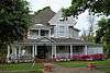 |
October 17, 1997 (#97001233) |
812 W. Pine St. 30°05′43″N 93°44′24″W / 30.095278°N 93.74°W |
Orange | Recorded Texas Historic Landmark |
| 3 | Lutcher Memorial Church Building |  |
September 9, 1982 (#82004517) |
902 W. Green Ave. 30°05′36″N 93°44′16″W / 30.093333°N 93.737778°W |
Orange | Recorded Texas Historic Landmark |
| 4 | Navy Park Historic District | December 22, 1999 (#99001600) |
Roughly bounded by W. Dewey Ave., Farragut St., Cooper's Gully Tract and 6th Ave. 30°06′27″N 93°43′54″W / 30.1075°N 93.731667°W |
Orange | ||
| 5 | Port Arthur-Orange Bridge | .jpg) |
October 10, 1996 (#96001127) |
TX 87 at the Jefferson and Orange County line 29°58′47″N 93°52′18″W / 29.979722°N 93.871667°W |
Groves | Historic Bridges of Texas, 1866-1945 MPS; extends into Jefferson County |
| 6 | Sims House |  |
March 26, 1980 (#80004143) |
905 Division St. 30°05′22″N 93°44′18″W / 30.089444°N 93.738333°W |
Orange | Recorded Texas Historic Landmark |
| 7 | W. H. Stark House |  |
December 12, 1976 (#76002056) |
611 W. Green Ave. 30°05′34″N 93°44′07″W / 30.092778°N 93.735278°W |
Orange | Recorded Texas Historic Landmark |
Former listing
| [3] | Name on the Register | Image | Date listed | Date removed | Location | City or town | Summary |
|---|---|---|---|---|---|---|---|
| 1 | Woodmen of the World Lodge-Phoenix Camp No. 32 | January 19, 1996 (#95001551) | November 17, 2010 | 110 Border St. 30°05′21″N 93°44′15″W / 30.0892°N 93.7375°W |
Orange | Recorded Texas Historic Landmark; significantly damaged by Hurricanes Rita and Ike. Demolished June 23, 2010.[5] |
See also
References
- ↑ "National Register of Historic Places: Weekly List Actions". National Park Service, United States Department of the Interior. Retrieved on October 11, 2018.
- ↑ The latitude and longitude information provided in this table was derived originally from the National Register Information System, which has been found to be fairly accurate for about 99% of listings. For about 1% of NRIS original coordinates, experience has shown that one or both coordinates are typos or otherwise extremely far off; some corrections may have been made. A more subtle problem causes many locations to be off by up to 150 yards, depending on location in the country: most NRIS coordinates were derived from tracing out latitude and longitudes from USGS topographical quadrant maps created under the North American Datum of 1927, which differs from the current, highly accurate WGS84 GPS system used by most on-line maps. Chicago is about right, but NRIS longitudes in Washington are higher by about 4.5 seconds, and are lower by about 2.0 seconds in Maine. Latitudes differ by about 1.0 second in Florida. Some locations in this table may have been corrected to current GPS standards.
- 1 2 Numbers represent an ordering by significant words. Various colorings, defined here, differentiate National Historic Landmarks and historic districts from other NRHP buildings, structures, sites or objects.
- ↑ The eight-digit number below each date is the number assigned to each location in the National Register Information System database, which can be viewed by clicking the number.
- ↑ Historical building slated for demolition » Local News » orangeleader.com (Orange, Texas) Archived 2012-03-04 at the Wayback Machine.
External links
![]()
Places adjacent to National Register of Historic Places listings in Orange County, Texas | ||||||||||
|---|---|---|---|---|---|---|---|---|---|---|
| ||||||||||


Municipalities and communities of Orange County, Texas, United States | ||
|---|---|---|
| Cities | | |
| CDP | ||
| Unincorporated communities | ||
| Ghost towns | ||
| Footnotes | ‡This populated place also has portions in an adjacent county or counties | |
This article is issued from
Wikipedia.
The text is licensed under Creative Commons - Attribution - Sharealike.
Additional terms may apply for the media files.