National Register of Historic Places listings in Waller County, Texas
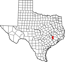
Location of Waller County in Texas
This is a list of the National Register of Historic Places listings in Waller County, Texas.
This is intended to be a complete list of properties listed on the National Register of Historic Places in Waller County, Texas. There are seven properties listed on the National Register in the county along with one property that has been removed. One property is a Recorded Texas Historic Landmark. The remainder belonged to a Multiple Property Submission of buildings on the campus of Prairie View A&M University.
- This National Park Service list is complete through NPS recent listings posted October 11, 2018.[1]
Current listings
The locations of National Register properties may be seen in a mapping service provided.[2]
| [3] | Name on the Register | Image | Date listed[4] | Location | City or town | Description |
|---|---|---|---|---|---|---|
| 1 | L.C. Anderson Hall |  |
June 3, 1999 (#99000611) |
L.W. Minor St., building #0541 30°05′38″N 95°59′26″W / 30.093889°N 95.990625°W |
Prairie View | Prairie View A&M University MPS |
| 2 | W.R. Banks Library | 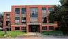 |
June 3, 1999 (#99000612) |
L.W. Minor St., building #0508 30°05′36″N 95°59′21″W / 30.093403°N 95.989236°W |
Prairie View | Prairie View A&M University MPS |
| 3 | Annie Laurie Evans Hall | 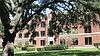 |
June 3, 1999 (#99000613) |
L.W. Minor St., building #0544 30°05′37″N 95°59′25″W / 30.093542°N 95.990208°W |
Prairie View | Prairie View A&M University MPS |
| 4 | Hilliard Hall | June 3, 1999 (#99000614) |
A.G. Cleaver St., building #0537 30°05′42″N 95°58′48″W / 30.095117°N 95.980103°W |
Prairie View | Prairie View A&M University MPS | |
| 5 | Liendo Plantation | 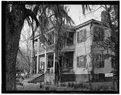 |
June 21, 1971 (#71000970) |
2 mi (3.2 km). NE of Hempstead off FM 1488 30°05′47″N 96°01′47″W / 30.096389°N 96.029722°W |
Hempstead | Recorded Texas Historic Landmark |
| 6 | Veterinary Hospital | 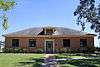 |
June 3, 1999 (#99000617) |
E.M. Norris St., building #0517 30°05′37″N 95°59′03″W / 30.0935°N 95.9841°W |
Prairie View | Prairie View A&M University MPS |
| 7 | G.R. Woolfolk Social and Political Science Building | 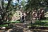 |
June 3, 1999 (#99000616) |
A.G. Cleaver St., building #0503 30°05′41″N 95°59′20″W / 30.094722°N 95.988958°W |
Prairie View | Prairie View A&M University MPS |
Former listings
| [3] | Name on the Register | Image | Date listed | Date removed | Location | City or town | Summary |
|---|---|---|---|---|---|---|---|
| 1 | Foster Hall | December 7, 1979 (#79003021) | June 3, 1999 | Prairie View A&M Campus |
Prairie View |
See also
References
- ↑ "National Register of Historic Places: Weekly List Actions". National Park Service, United States Department of the Interior. Retrieved on October 11, 2018.
- ↑ The latitude and longitude information provided in this table was derived originally from the National Register Information System, which has been found to be fairly accurate for about 99% of listings. For about 1% of NRIS original coordinates, experience has shown that one or both coordinates are typos or otherwise extremely far off; some corrections may have been made. A more subtle problem causes many locations to be off by up to 150 yards, depending on location in the country: most NRIS coordinates were derived from tracing out latitude and longitudes from USGS topographical quadrant maps created under the North American Datum of 1927, which differs from the current, highly accurate WGS84 GPS system used by most on-line maps. Chicago is about right, but NRIS longitudes in Washington are higher by about 4.5 seconds, and are lower by about 2.0 seconds in Maine. Latitudes differ by about 1.0 second in Florida. Some locations in this table may have been corrected to current GPS standards.
- 1 2 Numbers represent an ordering by significant words. Various colorings, defined here, differentiate National Historic Landmarks and historic districts from other NRHP buildings, structures, sites or objects.
- ↑ The eight-digit number below each date is the number assigned to each location in the National Register Information System database, which can be viewed by clicking the number.
External links
![]()
Places adjacent to National Register of Historic Places listings in Waller County, Texas | ||||||||||
|---|---|---|---|---|---|---|---|---|---|---|
| ||||||||||


Municipalities and communities of Waller County, Texas, United States | ||
|---|---|---|
| Cities | | |
| Town | ||
| Unincorporated communities | ||
| Footnotes | ‡This populated place also has portions in an adjacent county or counties | |
This article is issued from
Wikipedia.
The text is licensed under Creative Commons - Attribution - Sharealike.
Additional terms may apply for the media files.