National Register of Historic Places listings in Acadia Parish, Louisiana
Location of Acadia Parish in Louisiana
This is a list of the National Register of Historic Places listings in Acadia Parish, Louisiana.
This is intended to be a complete list of the properties on the National Register of Historic Places in Acadia Parish, Louisiana, United States. The locations of National Register properties for which the latitude and longitude coordinates are included below, may be seen in a map.[1]
There are 7 properties listed on the National Register in the parish. Another property was once listed, but has been removed.
- This National Park Service list is complete through NPS recent listings posted October 4, 2018.[2]
Current listings
| [3] | Name on the Register | Image | Date listed[4] | Location | City or town | Description |
|---|---|---|---|---|---|---|
| 1 | Joseph D. Bernard House | 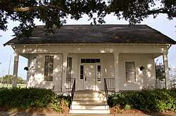 |
June 29, 2001 (#01000119) |
1023 The Boulevard 30°14′51″N 92°16′12″W / 30.2475°N 92.27007°W |
Rayne | |
| 2 | Colorado Southern Railroad Depot | 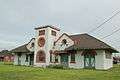 |
March 26, 1980 (#80001693) |
Corner of North Avenue G and East Front Street 30°12′36″N 92°22′12″W / 30.21001°N 92.37009°W |
Crowley | Also a contributing property to Crowley Historic District |
| 3 | Crowley Historic District | 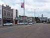 |
March 12, 1982 (#82002751) |
Roughly bounded by East 6th Street, North Avenue M, East 2nd Street, South Avenue H, East Ash Street, South Avenue G, East Mill Street and North Avenue F 30°12′39″N 92°22′18″W / 30.21082°N 92.37161°W |
Crowley | The 210 acres (85 ha) area historic district comprises a total of 266 buildings constructed between 1887 and 1931.[5] |
| 4 | Ellis Hoffpauir House | 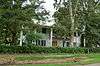 |
June 5, 1997 (#97000467) |
210 LeBlanc Street 30°10′56″N 92°27′52″W / 30.18209°N 92.46432°W |
Estherwood | |
| 5 | Istre Cemetery Grave Houses | 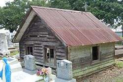 |
February 21, 2008 (#07000545) |
Along Swift Road, about 0.68 miles (1.09 km) south of intersection with Legros Road 30°06′56″N 92°33′55″W / 30.11561°N 92.56533°W |
Morse | |
| 6 | Le Vieux Presbytere |  |
May 30, 1997 (#97000508) |
101 South Rogers Street 30°24′22″N 92°12′56″W / 30.40621°N 92.21544°W |
Church Point | |
| 7 | St. Theresa Catholic Church and School | June 19, 2018 (#100002576) |
417 West 3rd Street 30°12′36″N 92°22′32″W / 30.20996°N 92.37556°W |
Crowley |
Former listings
| [3] | Name on the Register | Image | Date listed | Date removed | Location | City or town | Summary |
|---|---|---|---|---|---|---|---|
| 1 | Lewis & Taylor Lumberyard Office | July 14, 1995 (#95000812) | July 22, 2016 | 403 E. Louisiana Ave. 30°14′10″N 92°15′56″W / 30.23616°N 92.26555°W |
Rayne | Building demolished or heavily altered.[6] |
See also
| Wikimedia Commons has media related to National Register of Historic Places in Acadia Parish, Louisiana. |
References
- ↑ The latitude and longitude information provided in this table was derived originally from the National Register Information System, which has been found to be fairly accurate for about 99% of listings. For about 1% of NRIS original coordinates, experience has shown that one or both coordinates are typos or otherwise extremely far off; some corrections may have been made. A more subtle problem causes many locations to be off by up to 150 yards, depending on location in the country: most NRIS coordinates were derived from tracing out latitude and longitudes from USGS topographical quadrant maps created under the North American Datum of 1927, which differs from the current, highly accurate WGS84 GPS system used by most on-line maps. Chicago is about right, but NRIS longitudes in Washington are higher by about 4.5 seconds, and are lower by about 2.0 seconds in Maine. Latitudes differ by about 1.0 second in Florida. Some locations in this table may have been corrected to current GPS standards.
- ↑ "National Register of Historic Places: Weekly List Actions". National Park Service, United States Department of the Interior. Retrieved on October 4, 2018.
- 1 2 Numbers represent an ordering by significant words. Various colorings, defined here, differentiate National Historic Landmarks and historic districts from other NRHP buildings, structures, sites or objects.
- ↑ The eight-digit number below each date is the number assigned to each location in the National Register Information System database, which can be viewed by clicking the number.
- ↑ "Crowley Louisiana Historic District Design Guidelines" (PDF). April 2012. Retrieved 16 March 2018.
- ↑ "National Register of Historic Places Evaluation/Return Sheet - Removal: Lewis & Taylor Lumberyard Office" (PDF). National Park Service. Retrieved May 17, 2018.


Municipalities and communities of Acadia Parish, Louisiana, United States | ||
|---|---|---|
| Cities | | |
| Towns | ||
| Villages | ||
| CDPs | ||
| Other unincorporated communities |
| |
| Footnotes | ‡This populated place also has portions in an adjacent parish or parishes | |
This article is issued from
Wikipedia.
The text is licensed under Creative Commons - Attribution - Sharealike.
Additional terms may apply for the media files.