National Register of Historic Places listings in Grayson County, Texas
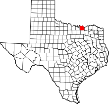
This is a list of the National Register of Historic Places listings in Grayson County, Texas.
This is intended to be a complete list of properties and districts listed on the National Register of Historic Places in Grayson County, Texas. There are one district and eight individual properties along with one former property listed on the National Register in the county. Seven individually listed properties are Recorded Texas Historic Landmarks including one that is also a State Historic Site. The district contains an additional Recorded Texas Historic Landmark.
- This National Park Service list is complete through NPS recent listings posted October 11, 2018.[1]
Current listings
The locations of National Register properties and districts may be seen in a mapping service provided.[2]
| [3] | Name on the Register | Image | Date listed[4] | Location | City or town | Description |
|---|---|---|---|---|---|---|
| 1 | Capt. Noble Allan Birge House | .jpg) |
September 18, 1986 (#86002187) |
727 W. Birge 33°38′42″N 96°37′05″W / 33.645°N 96.618056°W |
Sherman | Recorded Texas Historic Landmark |
| 2 | George Braun House | November 20, 1975 (#75001986) |
421 N. Austin Ave. 33°45′33″N 96°32′13″W / 33.759167°N 96.536944°W |
Denison | Demolished | |
| 3 | Denison Commercial Historic District | 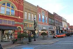 |
November 10, 1983 (#83003772) |
Roughly Woodard, Main and Chestnut Sts. 33°45′19″N 96°32′22″W / 33.755278°N 96.539444°W |
Denison | Includes Recorded Texas Historic Landmarks |
| 4 | Eisenhower Birthplace | .jpg) |
October 11, 2016 (#16000718) |
720 S. Lamar 33°44′54″N 96°32′01″W / 33.748414°N 96.533738°W |
Denison | State Historic Site, Recorded Texas Historic Landmark |
| 5 | Hall Furniture Building | 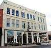 |
September 14, 2002 (#02000994) |
118 W. Lamar 33°38′08″N 96°36′34″W / 33.635556°N 96.609444°W |
Sherman | Recorded Texas Historic Landmark |
| 6 | Ernst Martin Kohl Building | 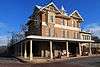 |
July 12, 1976 (#76002035) |
300 E. Main St. 33°45′17″N 96°31′54″W / 33.754722°N 96.531667°W |
Denison | Recorded Texas Historic Landmark; part of Denison Commercial Historic District |
| 7 | Old Sherman Public Library | 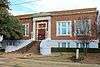 |
October 23, 1986 (#86002927) |
301 S. Walnut 33°38′05″N 96°36′24″W / 33.634722°N 96.606667°W |
Sherman | Recorded Texas Historic Landmark |
| 8 | Sherman US Post Office and Courthouse | 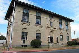 |
September 29, 2000 (#00001173) |
101 E. Pecan St. 33°38′20″N 96°36′33″W / 33.638889°N 96.609167°W |
Sherman | Recorded Texas Historic Landmark |
| 9 | Umphress-Taylor House | 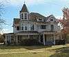 |
September 12, 1986 (#86001956) |
301 Paris St. 33°24′57″N 96°34′24″W / 33.415833°N 96.573333°W |
Van Alstyne | Recorded Texas Historic Landmark |
Former listings
| [3] | Name on the Register | Image | Date listed | Date removed | Location | City or town | Summary |
|---|---|---|---|---|---|---|---|
| 1 | Clifton House Hotel | April 24, 1986 (#86000948) | September 9, 1991 | 229 W. Gandy |
Denison |
See also
References
- ↑ "National Register of Historic Places: Weekly List Actions". National Park Service, United States Department of the Interior. Retrieved on October 11, 2018.
- ↑ The latitude and longitude information provided in this table was derived originally from the National Register Information System, which has been found to be fairly accurate for about 99% of listings. For about 1% of NRIS original coordinates, experience has shown that one or both coordinates are typos or otherwise extremely far off; some corrections may have been made. A more subtle problem causes many locations to be off by up to 150 yards, depending on location in the country: most NRIS coordinates were derived from tracing out latitude and longitudes from USGS topographical quadrant maps created under the North American Datum of 1927, which differs from the current, highly accurate WGS84 GPS system used by most on-line maps. Chicago is about right, but NRIS longitudes in Washington are higher by about 4.5 seconds, and are lower by about 2.0 seconds in Maine. Latitudes differ by about 1.0 second in Florida. Some locations in this table may have been corrected to current GPS standards.
- 1 2 Numbers represent an ordering by significant words. Various colorings, defined here, differentiate National Historic Landmarks and historic districts from other NRHP buildings, structures, sites or objects.
- ↑ The eight-digit number below each date is the number assigned to each location in the National Register Information System database, which can be viewed by clicking the number.
External links
![]()


Municipalities and communities of Grayson County, Texas, United States | ||
|---|---|---|
| Cities | | |
| Towns | ||
| CDPs | ||
| Other unincorporated communities | ||
| Footnotes | ‡This populated place also has portions in an adjacent county or counties | |