National Register of Historic Places listings in Claiborne Parish, Louisiana
Location of Claiborne Parish in Louisiana
This is a list of the National Register of Historic Places listings in Claiborne Parish, Louisiana.
This is intended to be a complete list of the properties on the National Register of Historic Places in Claiborne Parish, Louisiana, United States. The locations of National Register properties for which the latitude and longitude coordinates are included below, may be seen in a map.[1]
There are 11 properties listed on the National Register in the parish.
- This National Park Service list is complete through NPS recent listings posted October 4, 2018.[2]
Current listings
| [3] | Name on the Register | Image | Date listed[4] | Location | City or town | Description |
|---|---|---|---|---|---|---|
| 1 | Arizona Methodist Church | December 22, 1983 (#83003608) |
Along Arizona Road (LA 806), about 1.5 miles (2.4 km) south of its junction with LA 2 32°47′14″N 92°57′28″W / 32.78728°N 92.95768°W |
Arizona | ||
| 2 | J.W. Burnham House | January 22, 1987 (#86003671) |
Along Maddox Road, about 3.5 miles (5.6 km) east of Haynesville 32°56′59″N 93°04′50″W / 32.9498°N 93.08051°W |
Haynesville | ||
| 3 | Capers-McKenzie House | June 30, 1983 (#83000496) |
708 Belmont Street 32°47′46″N 93°03′25″W / 32.79617°N 93.05687°W |
Homer | ||
| 4 | Claiborne Parish Courthouse |  |
October 7, 1981 (#81000291) |
Courthouse Square 32°47′30″N 93°03′18″W / 32.79157°N 93.05502°W |
Homer | Also a contributing property to Homer Historic District since its creation on August 28, 1986.[5] |
| 5 | Friendship CME Church | May 31, 2016 (#16000297) |
1055 Friendship Road, about 4.2 miles (6.8 km) north of Lisbon 32°51′21″N 92°52′36″W / 32.855726°N 92.876731°W |
Lisbon | Focal point of small African-American community of Friendship; built in 1933 after predecessor lost in a tornado. | |
| 6 | Homer Historic District | 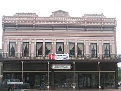 |
August 28, 1986 (#86001994) |
Roughly bounded by North 2nd Street, East Main Street, South 3rd Street, Fulmer Street Third, West Main Street and West 2nd Street 32°47′26″N 93°03′18″W / 32.79061°N 93.05509°W |
Homer | |
| 7 | Killgore House | May 14, 1987 (#87000731) |
About 80 yards (73 m) west of junction of LA 2 and LA 518 32°47′45″N 92°52′23″W / 32.7958°N 92.87308°W |
Lisbon | Also known as Rocky Springs Plantation | |
| 8 | Monk House | August 23, 1991 (#91001081) |
Along Parish Road 39, about 8.5 miles (13.7 km) northeast of Homer 32°53′21″N 92°57′56″W / 32.88903°N 92.96547°W |
Homer | ||
| 9 | Dr. John W. Todd House | January 22, 1987 (#86003683) |
306 East 5th Street 32°47′20″N 93°02′48″W / 32.78901°N 93.0466°W |
Homer | ||
| 10 | Tulip Methodist Church | August 13, 1987 (#87001367) |
At the junction of Parish Road 177 and Point Pleasant Road, about 3.3 miles (5.3 km) northeast of Athens 32°40′55″N 92°58′59″W / 32.68189°N 92.983°W |
Athens | ||
| 11 | Alberry Wasson Homeplace | June 25, 1982 (#82002766) |
Along Wasson Road, about 1.2 miles (1.9 km) southwest of Summerfield 32°53′55″N 92°50′29″W / 32.89873°N 92.84143°W |
Summerfield |
See also
| Wikimedia Commons has media related to National Register of Historic Places in Claiborne Parish, Louisiana. |
References
- ↑ The latitude and longitude information provided in this table was derived originally from the National Register Information System, which has been found to be fairly accurate for about 99% of listings. For about 1% of NRIS original coordinates, experience has shown that one or both coordinates are typos or otherwise extremely far off; some corrections may have been made. A more subtle problem causes many locations to be off by up to 150 yards, depending on location in the country: most NRIS coordinates were derived from tracing out latitude and longitudes from USGS topographical quadrant maps created under the North American Datum of 1927, which differs from the current, highly accurate WGS84 GPS system used by most on-line maps. Chicago is about right, but NRIS longitudes in Washington are higher by about 4.5 seconds, and are lower by about 2.0 seconds in Maine. Latitudes differ by about 1.0 second in Florida. Some locations in this table may have been corrected to current GPS standards.
- ↑ "National Register of Historic Places: Weekly List Actions". National Park Service, United States Department of the Interior. Retrieved on October 4, 2018.
- ↑ Numbers represent an ordering by significant words. Various colorings, defined here, differentiate National Historic Landmarks and historic districts from other NRHP buildings, structures, sites or objects.
- ↑ The eight-digit number below each date is the number assigned to each location in the National Register Information System database, which can be viewed by clicking the number.
- ↑ "Homer Historic District" (PDF). State of Louisiana's Division of Historic Preservation. 1986. Retrieved April 27, 2018. with four photos and three maps


Municipalities and communities of Claiborne Parish, Louisiana, United States | ||
|---|---|---|
| Towns | | |
| Villages | ||
| Unincorporated communities | ||
| Footnotes | ‡This populated place also has portions in an adjacent parish or parishes | |
This article is issued from
Wikipedia.
The text is licensed under Creative Commons - Attribution - Sharealike.
Additional terms may apply for the media files.