National Register of Historic Places listings in Llano County, Texas
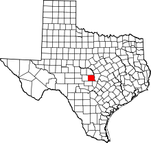
This is a list of the National Register of Historic Places listings in Llano County, Texas.
This is intended to be a complete list of properties and districts listed on the National Register of Historic Places in Llano County, Texas. There are three districts and four individual properties listed on the National Register in the county. One district is a National Natural Landmark while two other districts contain Recorded Texas Historic Landmarks (RTHLs) including one State Antiquities Landmark that is part of an individual listing along with another RTHL. Two additional individual listings are also RTHLs.
- This National Park Service list is complete through NPS recent listings posted October 11, 2018.[1]
Current listings
The locations of National Register properties and districts may be seen in a mapping service provided.[2]
| [3] | Name on the Register | Image | Date listed[4] | Location | City or town | Description |
|---|---|---|---|---|---|---|
| 1 | Austin and Northwestern Railroad Historic District-Fairland to Llano | 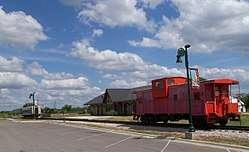 |
October 6, 1997 (#97001161) |
Roughly along RR tracks from Fairland to Llano 30°39′38″N 98°26′12″W / 30.660556°N 98.436667°W |
Kingsland | Includes Recorded Texas Historic Landmark; extends into Burnet County |
| 2 | Badu Building | 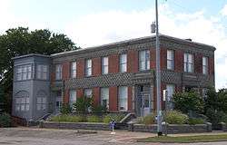 |
June 6, 1980 (#80004139) |
601 Bessemer Ave. 30°45′24″N 98°40′34″W / 30.756667°N 98.676111°W |
Llano | Recorded Texas Historic Landmark |
| 3 | Enchanted Rock Archeological District | 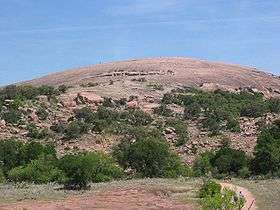 |
August 29, 1984 (#84001740) |
Off Ranch Rd 965 at the Llano-Gillespie County Line 30°30′16″N 98°49′05″W / 30.504444°N 98.818056°W |
Fredericksburg | National Natural Landmark; extends into Gillespie County |
| 4 | Llano County Courthouse and Jail | 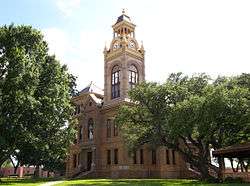 |
December 2, 1977 (#77001459) |
Public Sq., Oatman and Haynie Sts. 30°44′59″N 98°40′35″W / 30.749722°N 98.676389°W |
Llano | Contains Recorded Texas Historic Landmarks including one State Antiquities Landmark; the courthouse is within the Llano County Courthouse Historic District |
| 5 | Llano County Courthouse Historic District | 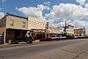 |
February 10, 1989 (#88002542) |
Roughly bounded by the Llano River, Ford St., Sandstone St., and Berry St. 30°45′05″N 98°40′34″W / 30.751389°N 98.676111°W |
Llano | Contains Recorded Texas Historic Landmarks including one State Antiquities Landmark |
| 6 | Southern Hotel | 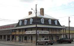 |
October 10, 1979 (#79002992) |
201 W. Main St 30°45′01″N 98°40′38″W / 30.750278°N 98.677222°W |
Llano | Recorded Texas Historic Landmark |
| 7 | State Highway 29 Bridge at the Colorado River | 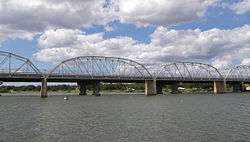 |
October 10, 1996 (#96001116) |
TX 29 at the Llano County line 30°44′53″N 98°23′54″W / 30.748056°N 98.398333°W |
Buchanan Dam | Extends into Burnet County |
See also
References
- ↑ "National Register of Historic Places: Weekly List Actions". National Park Service, United States Department of the Interior. Retrieved on October 11, 2018.
- ↑ The latitude and longitude information provided in this table was derived originally from the National Register Information System, which has been found to be fairly accurate for about 99% of listings. For about 1% of NRIS original coordinates, experience has shown that one or both coordinates are typos or otherwise extremely far off; some corrections may have been made. A more subtle problem causes many locations to be off by up to 150 yards, depending on location in the country: most NRIS coordinates were derived from tracing out latitude and longitudes from USGS topographical quadrant maps created under the North American Datum of 1927, which differs from the current, highly accurate WGS84 GPS system used by most on-line maps. Chicago is about right, but NRIS longitudes in Washington are higher by about 4.5 seconds, and are lower by about 2.0 seconds in Maine. Latitudes differ by about 1.0 second in Florida. Some locations in this table may have been corrected to current GPS standards.
- ↑ Numbers represent an ordering by significant words. Various colorings, defined here, differentiate National Historic Landmarks and historic districts from other NRHP buildings, structures, sites or objects.
- ↑ The eight-digit number below each date is the number assigned to each location in the National Register Information System database, which can be viewed by clicking the number.
External links
![]()
Places adjacent to National Register of Historic Places listings in Llano County, Texas | ||||||||||
|---|---|---|---|---|---|---|---|---|---|---|
| ||||||||||


Municipalities and communities of Llano County, Texas, United States | ||
|---|---|---|
| Cities | | |
| CDPs | ||
| Other unincorporated communities | ||
| Ghost towns | ||
| Footnotes | ‡This populated place also has portions in an adjacent county or counties | |