Baranagar
| Baranagar | |
|---|---|
| Neighbourhood | |
 River Hoogly at Baranagar, Vivekananda Bridge far away. | |
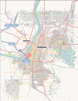 Baranagar Location in Kolkata | |
| Coordinates: 22°38′N 88°22′E / 22.64°N 88.37°ECoordinates: 22°38′N 88°22′E / 22.64°N 88.37°E | |
| Country |
|
| State | West Bengal |
| City | Kolkata |
| Government | |
| • Municipality Chairman | Aparna Moulik[1][2] |
| Area | |
| • Total | 7.12 km2 (2.75 sq mi) |
| Elevation | 12 m (39 ft) |
| Population (2011) | |
| • Total | 245,313 |
| • Density | 34,000/km2 (89,000/sq mi) |
| Languages | |
| • Official | Bengali and English |
| Time zone | UTC+5:30 (IST) |
| Area code(s) | 33 |
| Lok Sabha constituency | Dum Dum |
| Vidhan Sabha constituency | Baranagar |
Baranagar (in Bengali: বরানগর or বরাহনগর) is a city with a municipality in Barrackpore subdivision of North 24 Parganas district, in West Bengal, India. It is a part of Kolkata Urban Agglomeration.
It is home to the Indian Statistical Institute, an institution of national importance devoted to the research, teaching and application of statistics, natural sciences and social sciences. Baranagore Ramakrishna Mission Ashrama High School is one of the oldest and renowned school in Baranagar and North 24 Parganas.
Baranagar is a major industrial centre for the manufacture of agricultural and industrial machinery, chemicals, castor oil, and matches; there are also numerous cotton-processing companies.
History
The Dutch had homes here in the seventeenth century. Streynsham Master who visited the area in 1676 spoke of the hog factory where about 3,000 hogs a year were slaughtered and salted for export. Later it became the centre for the extensive jute trade, manufacturing gunny bags.[3] A major road parallel to the river Hooghly connects Baranagar Bazaar with Dakshineswar. In between temples such as Kaancher Mandir (i.e. Glass Temple), Joy Mitra Kali Bari, and Pathbari are located.
In Kutighat (Baranagar), still there is an old house/lodge of Dutch merchants.
Famous residents
- Ramakrishna
- Sitaramdas Omkarnath
- Sarada Devi
- Swami Vivekananda
- Ramakrishnananda
- Swami Brahmananda
- Rani Rashmoni
- Sasipada Banerji
- Rajkumari Banerji
- Albion Rajkumar Banerjee
- Manik Bandopadhyay
- Prasanta Chandra Mahalanobis
- Rabindranath Tagore
- Rudraprasad Sengupta
- Swatilekha Sengupta
- Sohini Sengupta
- Jeet Gannguli
- Shiboprosad Mukherjee
- Abhishek Chatterjee
- Shaan
- Dola Banerjee
- Rahul Banerjee
- Sagarika
- Bidyut Baran Chaudhuri
- C. A. Murthy
Geography
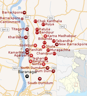 |
| Cities and towns in the southern portion of Barrackpore subdivision in North 24 Parganas district M: municipal city/ town, CT: census town, N: neighbourhood/ administrative location Owing to space constraints in the small map, the actual locations in a larger map may vary slightly |
Location
Baranagar is located at 22°38′N 88°22′E / 22.64°N 88.37°E.[4] It has an average elevation of 12 metres (39 feet).It is situated east of the Hooghly River. Baranagar Municipal Area lies between Sinthee More and Dunlop.
More particularly to say, the boundary of Baranagar is – in the east, the Rail line from Sealdah towards Krishnanagar; in the west – the holy river Ganga, in the north – PWD road and in the south – Baranagar Bazaar. It is connected by the holy Ganges to Dakshineshwar temple which lies just a quarter of a mile from this place. There are many Ganga ghats in Baranagar for example Pramanic ghat, Kutighat, Dakshineshwar ghat, Kancher mandir or glass temple ghat.
96% of the population of Barrackpore subdivision (partly presented in the map alongside, all places marked on the map are linked in the full screen map) lives in urban areas. In 2011, it had a density of population of 10,967 per km2 The subdivision has 16 municipalities and 24 census towns.[5]
For most of the cities/ towns information regarding density of population is available in the Infobox. Population data is not available for neighbourhoods. It is available for the entire municipal area and thereafter ward-wise.
Police station
Baranagar police station under Barrackpore Police Commissionerate has jurisdiction over Baranagar municipal area.[6][7]
Demographics
Population
| Population of Baranagar | |||
|---|---|---|---|
| Census | Pop. | %± | |
| 1901 | 25,432 | — | |
| 1911 | 25,895 | 1.8% | |
| 1921 | 32,084 | 23.9% | |
| 1931 | 37,050 | 15.5% | |
| 1941 | 54,451 | 47.0% | |
| 1951 | 77,126 | 41.6% | |
| 1961 | 107,837 | 39.8% | |
| 1971 | 136,842 | 26.9% | |
| 1981 | 170,343 | 24.5% | |
| 1991 | 224,831 | 32.0% | |
| 2001 | 250,768 | 11.5% | |
| 2011 | 245,213 | -2.2% | |
| Source: [8] | |||
As per the 2011 Census of India, Baranagar had a total population of 245,213, of which 126,187 (51%) were males and 119,026 (49%) were females. Population below 6 years was 16,825. The total number of literates in Baranagar was 208,779 (91.41% of the population over 6 years).[9]
As of 2001 India census,[10] Baranagar had a population of 250,615. Males constitute 53% of the population and females 47%. Baranagar has an average literacy rate of 82%, higher than the national average of 59.5%; with 55% of the males and 45% of females literate. 8% of the population is under 6 years of age.
Kolkata Urban Agglomeration
The following Municipalities, Census Towns and other locations in Barrackpore subdivision were part of Kolkata Urban Agglomeration in the 2011 census: Kanchrapara (M), Jetia (CT), Halisahar (M), Balibhara (CT), Naihati (M), Bhatpara (M), Kaugachhi (CT), Garshyamnagar (CT), Garulia (M), Ichhapur Defence Estate (CT), North Barrackpur (M), Barrackpur Cantonment (CB), Barrackpore (M), Jafarpur (CT), Ruiya (CT), Titagarh (M), Khardaha (M), Bandipur (CT), Panihati (M), Muragachha (CT) New Barrackpore (M), Chandpur (CT), Talbandha (CT), Patulia (CT), Kamarhati (M), Baranagar (M), South Dumdum (M), North Dumdum (M), Dum Dum (M), Noapara (CT), Babanpur (CT), Teghari (CT), Nanna (OG), Chakla (OG), Srotribati (OG) and Panpur (OG).[11]
Infrastructure
As per the District Census Handbook 2011, Baranagar municipal city covered an area of 7.12 km2. Amongst the civic amenities it had 160.23 km of roads and both open and closed drains. Amongst the medical facilities It had 55 medicine shops. Amongst the educational facilities it had 49 primary schools, 33 middle schools, 33 secondary schools, many higher secondary schools and 2 non-formal education centres. Amongst the social, recreational and cultural facilities it had 2 cinema/theatres and 2 auditorium/ community halls. It had 20 bank branches.[12]
Economy
KMDA
Baranagar municipality is included in the Kolkata Metropolitan Area for which the KMDA is the statutory planning and development authority.[13][14]
Transport
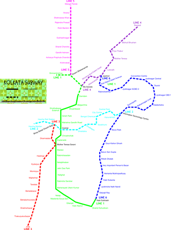
Barrackpore Trunk Road passes through Baranagar.[15]"Baranagar Road Railway Station" is situated in Baranagar, it is a Kolkata suburban railway station. Noapara metro station is also situated here. Transport in water pathway is held by boat and bhutbhuti from Kuthighat to Howrah district.
Education
Baranagar houses the headquarters of the Indian Statistical Institute. Among the other less known colleges of Baranagar are Brahmananda Keshab Chandra College, Prasanta Chandra Mahalanobis Mahavidyalaya. Baranagar is also home to some schools like Baranagar Vidyamandir (Primary, Secondary and H.S., for boys and girls), Baranagore Ramakrishna Mission Ashrama High School,[16] Ramakrishna Mission Centenary Primary School, Baranagaore, Baranagar Narendranath Vidyamandir, Rajkumari Memorial Girls' School, Khalsa Model Senior Secondary School, Dunlop Bridge (Started by Sikh Sangat Gurdwara, Dunlop Bridge), Ananda Ashram Sarada Vidyapith, Baranagar Netaji Colony Bharti Girls' Institution, Netaji High School, Baranagar Rameswar H.S. School, Baranagar Victoria School, Kuthighat, Ashokegarh Adarsha Vidyalaya, Jyotinagar Bidyashree Niketan, Sinthi Ram Krishna Sangha Vidya Mandir, Sinthee Ray Bahadur Badridas Tulsan Vidyapith, Mata Monmohini Secondary School, Baranagar Mayapith Girls' High School, Delhi Public School [North Kolkata] etc., and a Higher Secondary Urdu-medium school, Alambazar Urdu High school providing quality education to the local people.
Health Facilities
Following hospitals are located in Baranagar:
- Baranagar State General Hospital
- Disha Eye Hospital, Sinthi
- National Institute for the Orthopedically Handicapped (NIOH)
- Baine Hospital
Culture
Baranagar Math near Pramanick ghat is the place where Swami Vivekananda and a few other disciples of Sri Ramakrishna Dev started their spiritual journey that culminated in forming the monastic order later located at Belur Math, the present headquarters of Ramakrishna Mission.[17]Other places worth visiting are Jay Mitra Kalibari, Pramanick Kalibari, and Kouleswar Mandir. Pathbari Mandir is a place where Chaitanya Mahaprabhu, the great religious leader, set his foot on his way to Puri nearly five hundred years ago here. In Baranagar a math has been set up very recently, called Alambazar Math in the heritage building where Swami Vivekananda first put up after coming back from abroad.[18] Tha Annapurna Temple and the newly built Omkarnath Temple are also other two attractions of the Mahamilan Math. Trailanga Swami Math is also here in Baranagar at Vidyayatan Sarani. There is also an old kalibari in Baranagar Bazar and one in Kutighat and Pramanicghat.
Baranagar has a gurdwara near Dunlop Bridge, a church near Sinthee More along with many mosques.
References
- ↑ Official District Administration site Archived 15 January 2007 at the Wayback Machine.
- ↑ "Welcome to www.baranagarmunicipality.org". Retrieved 17 May 2015.
- ↑ Cotton, H.E.A., Calcutta Old and New, 1909/1980, pp 806–807, General Printers and Publishers Pvt. Ltd.
- ↑ "Maps, Weather, and Airports for Baranagar, India". Retrieved 17 May 2015.
- ↑ "District Statistical Handbook". North 24 Parganas 2013, Tables 2.1, 2.2, 2.4b. Department of Statistics and Programme Implementation, Government of West Bengal. Retrieved 2 May 2018.
- ↑ "District Statistical Handbook". North 24 Parganas 2013, Tables 2.1, 2.2, 2.4b. Department of Statistics and Programme Implementation, Government of West Bengal. Retrieved 11 June 2018.
- ↑ "Barrackpore Police Commissionerate". List of Police Stations with telephone numbers. West Bengal Police. Retrieved 11 June 2018.
- ↑ "District Census Handbook North Twenty Four Parganas, Census of India 2011, Series 20, Part XII A" (PDF). Section II Town Directory, Pages 781-783 Statement I: Growth History, Pages 799-803. Directorate of Census Operations V, West Bengal. Retrieved 11 June 2018.
- ↑ "2011 Census – Primary Census Abstract Data Tables". West Bengal – District-wise. Registrar General and Census Commissioner, India. Retrieved 7 June 2018.
- ↑ "Census of India 2001: Data from the 2001 Census, including cities, villages and towns (Provisional)". Census Commission of India. Archived from the original on 16 June 2004. Retrieved 1 November 2008.
- ↑ "Provisional Population Totals, Census of India 2011" (PDF). Constituents of Urban Agglomeration Having Population Above 1 Lakh. Census of India 2011. Retrieved 7 June 2018.
- ↑ "District Census Handbook North Twenty Four Parganas, Census of India 2011, Series 20, Part XII A" (PDF). Section II Town Directory, Pages 781-783 Statement I: Growth History, Pages 799-803; Statement II: Physical Aspects and Location of Towns, Pages 791-794; Statement III: Civic and other Amenities, Pages 795-796; Statement IV: Medical Facilities 2009, Pages 803-805 Section: Educational, Recreational and Cultural Facilities. Directorate of Census Operations V, West Bengal. Retrieved 31 May 2018.
- ↑ "Kolkata Metropolitan Development Authoity, Annual Report 2010-11". 1/1 Kolkata Metropolitan Area Map. KMDA. Retrieved 7 June 2018.
- ↑ "Kolkata Metropolitan Development Authority, Annual Report 2010-11". 1 / 2 Role of KMDA. KMDA. Retrieved 7 June 2018.
- ↑ Google maps
- ↑ "Ramakrishna Mission Ashrama, Baranagar Mission". Retrieved 17 May 2015.
- ↑ "RKM – Index". Retrieved 17 May 2015.
- ↑ "AlambazarMath". Archived from the original on 10 January 2014. Retrieved 9 September 2013.
External links
![]()