Ashburton, New Zealand
| Ashburton Hakatere (Māori) | |
|---|---|
| Secondary urban area | |
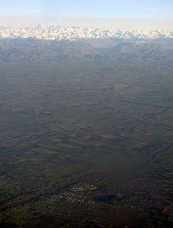
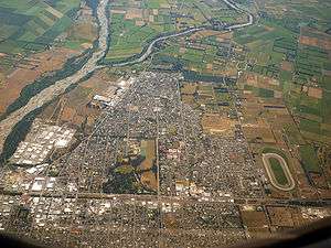 Aerial view of Ashburton, looking west. The Ashburton River or Hakatere is visible at left. | |
| Nickname(s): Ashvegas | |
|
Ashburton Ashburton | |
| Coordinates: 43°54′20″S 171°44′44″E / 43.90556°S 171.74556°ECoordinates: 43°54′20″S 171°44′44″E / 43.90556°S 171.74556°E | |
| Country |
|
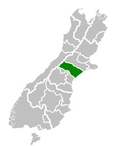
| Region | Canterbury |
| District | Ashburton District Council |
| Wards |
Ashburton Eastern Western |
| Electorates |
Rangitata Te Tai Tonga (Maori electorate)[1] |
| Government[2] | |
| • Mayor | Donna Favel |
| Area | |
| • Territorial | 6,187.40 km2 (2,388.97 sq mi) |
| Population (June 2017)[3] | |
| • Territorial | 34,100 |
| • Density | 5.5/km2 (14/sq mi) |
| • Urban | 20,000 |
| Demonym(s) | Ashburtonian |
| Time zone | UTC+12 (NZST) |
| • Summer (DST) | UTC+13 (NZDT) |
| Postcode(s) | Map of postcodes |
| Postcode(s) | 7700 |
| Area code(s) | 03 |
| Local iwi | Ngāi Tahu |
| Website | Ashburton District Council |
Ashburton or Hakatere (Māori) is a large town in the Canterbury Region, on the east coast of the South Island of New Zealand. The town is the seat of the Ashburton District, a territorial authority encompassing the town and a number of small settlements within its surrounding rural area, roughly coterminous with the subregion of Mid Canterbury. It is 85 kilometres (53 mi) south west of Christchurch and is sometimes regarded as a satellite town of Christchurch.[4]
Ashburton township has a population of 20,000, with an additional 12,400 living in the wider district. The town is the 23rd largest urban area in New Zealand and the third-largest urban area in the Canterbury Region, after Christchurch and Timaru.
Naming
Ashburton was named by the surveyor Captain Joseph Thomas of the New Zealand Land Association, after Francis Baring, 3rd Baron Ashburton, who was a member of the Canterbury Association. The town is laid out around two central squares either side of the railway line and main highway, Baring Square East and Baring Square West.
"Ashvegas", Ashburton's common nickname, is an ironic allusion to Las Vegas.[6]
Location
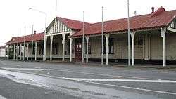
Ashburton is on State Highway 1 86 kilometres (53 mi) south of Christchurch. The Main South Line railway line runs through the centre of town, but passenger trains ceased on 10 February 2002. The town is the centre of an agricultural and pastoral farming district, part of the Canterbury Plains. It has one large suburb, Tinwald, south of the town and the Ashburton River. Tinwald was the junction for the now-closed Mount Somers Branch railway line. The town has three other suburbs: Allenton, Hampstead and Netherby.
The Ashburton District extends from the Pacific Ocean to the Southern Alps, and from the Rangitata River to the Rakaia River, including the towns of Methven, Mount Somers, and Rakaia.
Climate
On the whole, Ashburton shares a similar climate to Christchurch i.e. a dry temperate climate (Cfb). However, since it lies further inland at a higher altitude to Christchurch, Ashburton experiences a greater range of temperatures. During summer Ashburton can exceed 30 °C (86 °F), whilst winter can see regular frosts and annual snowfall. Ashburton's heaviest snowfall was 60 centimetres (24 in) on 12 June 2006.
| Climate data for Ashburton | |||||||||||||
|---|---|---|---|---|---|---|---|---|---|---|---|---|---|
| Month | Jan | Feb | Mar | Apr | May | Jun | Jul | Aug | Sep | Oct | Nov | Dec | Year |
| Average high °C (°F) | 23.7 (74.7) |
23.0 (73.4) |
21.0 (69.8) |
17.9 (64.2) |
13.9 (57) |
11.2 (52.2) |
10.7 (51.3) |
12.3 (54.1) |
15.2 (59.4) |
18.0 (64.4) |
19.9 (67.8) |
22.0 (71.6) |
17.4 (63.3) |
| Average low °C (°F) | 11.1 (52) |
10.8 (51.4) |
9.5 (49.1) |
6.4 (43.5) |
3.4 (38.1) |
0.9 (33.6) |
0.5 (32.9) |
1.8 (35.2) |
3.8 (38.8) |
6.0 (42.8) |
7.9 (46.2) |
9.9 (49.8) |
6.0 (42.8) |
| Average precipitation mm (inches) | 58.5 (2.303) |
53.6 (2.11) |
62.5 (2.461) |
65.5 (2.579) |
61.6 (2.425) |
51.1 (2.012) |
62.7 (2.469) |
66.1 (2.602) |
43.7 (1.72) |
56.6 (2.228) |
57.8 (2.276) |
56.2 (2.213) |
696.2 (27.409) |
| Source: NIWA Science climate data[7] | |||||||||||||
Economy
Ashburton lies in the middle of the fertile alluvial Canterbury Plains which permits agricultural activity such as dairying provided irrigation is used.
In 2012, Ashburton was noted for having more cooperative companies operating in its district than in any other area of New Zealand, and was subsequently named by the New Zealand Cooperatives Association the "Cooperative Capital of New Zealand". Several of the 40-plus companies are national companies based outside the district, such as Fonterra, Foodstuffs and Silver Fern Farms (meat processing), but many were local cooperatives, such as the Ashburton Trading Society (farm supplies) and Electricity Ashburton (electricity distribution).[8]
Ashburton media includes the Ashburton Guardian daily newspaper, the Mid Canterbury Herald, a free weekly community newspaper owned by Fairfax Media which comes out every Wednesday, The Courier, another free weekly community newspaper owned by the Otago Daily Times, and the Mid Canterbury-focused AshburtonOnline website. Radio Port FM is based in Timaru; Newstalk ZB and Classic Hits ZEFM are re-broadcast from other out-of-town stations.
There is a small recreational airport, Ashburton Aerodrome, serving the town.
Education
There are seven primary schools, an intermediate school, a secondary school and a composite school in Ashburton. All rolls are as of August 2018.[9]
- Allenton School is a state contributing primary (Year 1–6) school. It has a roll of 395 students.
- Ashburton Borough School is a state full primary (Year 1–8) school. It has a roll of 443 students.
- Ashburton Christian School is a state-integrated evangelical Christian composite (Year 1–13) school. The school opened in February 2009 as a private school, and integrated into the state system in March 2011. It has a roll of 123 students.
- Ashburton College is a state secondary (Year 9–13) school. The school opened in 1965 following the merger of Ashburton High School and Hakatere College. It has a roll of 1151 students.
- Ashburton Intermediate School is a state intermediate (Year 7–8) school. The school opened in 1974. It has a roll of 390 students.
- Ashburton Netherby School is a state contributing primary school. The school opened in 1959. It has a roll of 148 students.
- Fairton School is a state contributing primary school. It has a roll of 34 students.
- Hampstead School is a state contributing primary school. It has a roll of 348 students.
- St Joseph's School is a state-integrated Catholic full primary school. It has a roll of 263 students.
- Tinwald School is a state contributing primary school. It has a roll of 233 students.
- Wakanui School is a state full primary school. It has a roll of 127 students.
Recreation
There is a cinema, swimming pool and two local golf courses. There is a walking track coastwards along the northern side of the river from SH 1. The same track extends west along the river with a mountainbike track. The Ashburton Museum and Art Gallery share one building, which sits on State Highway 1, just outside the centre of town.
The Ashburton Club and Mutual School of Arts (MSA) was founded in 1885. The MSA is a member of the NZ Chartered Clubs Association and is located in the central town. The club itself currently has around 4,000 members on its records.[10]
The Aerodrome located near the town centre and is an active light (GA and Microlight) aviation hub and home of the Mid Canterbury Aero Club (GA) and Ashburton Aviation Pioneers.
The beaches adjacent to Ashburton are steep and shingly with a strong undertow, making them unsafe to swim, but suitable for surf-casting. In part to rectify the limitations imposed by the lack of recreational waterways, Lake Hood was constructed just south-east of Tinwald. The Ashburton, Rakaia, and Rangitata Rivers are suitable for fishing, the Rakaia in particular is renowned worldwide for its salmon fishing. Upper reaches of the Rangitata are frequently kayaked and rafted, reaching Grades 3–4. The Rakaia is known for jet-boating. The Ashburton lakes Lake Heron, Lake Camp and Lake Clearwater are inland. On the road to these lakes are Mount Somers and the Mount Somers walkway.
Mount Hutt is a South Island ski field an hour inland, just past Methven.
Prominent residents
Prominent residents have included the former Prime Minister of New Zealand, Jenny Shipley, international operatic tenor Simon O'Neill, Olympic silver medal cyclist Hayden Roulston and New Zealand television and radio personalities Simon Barnett and Robyn Malcolm.
Rugby union player Chris King was born in Ashburton.
Hugo Friedlander was the second Mayor of Ashburton (1879–1881, 1890–1892 and 1898–1901), but left for Auckland in 1918 due to anti-German feelings caused by WWI.[11]
John Grigg was a local landowner and Member of Parliament in the mid 19th century.
Notes
- ↑ "Find my Electorate | Electoral Commission". Elections.org.nz. 2017-02-25. Retrieved 2017-03-19.
- ↑ "Mayor Bede O'Malley". Ashburton District Council. Archived from the original on 1 December 2007. Retrieved 30 October 2009.
- ↑ "Subnational Population Estimates: At 30 June 2017 (provisional)". Statistics New Zealand. 24 October 2017. Retrieved 24 October 2017. For urban areas, "Subnational population estimates (UA, AU), by age and sex, at 30 June 1996, 2001, 2006-16 (2017 boundary)". Statistics New Zealand. 24 October 2017. Retrieved 24 October 2017.
- ↑ Editorial comment 15 June 2011 – Ashburton Guardian Archived 3 April 2012 at the Wayback Machine.
- ↑ "Rail Heritage Trust of New Zealand – Ashburton Station and Footbridge". www.railheritage.org.nz. Retrieved 10 February 2016.
- ↑ Peters, Pam; Collins, Peter; Smith, Adam (2009). Comparative Studies in Australian and New Zealand English: Grammar and Beyond. John Benjamins. p. 57.
- ↑ "Ashburton, New Zealand: Climate, Global Warming, and Daylight Charts and Data". Climate-charts.com. Ashburton, New Zealand. Retrieved 2017-03-19.
- ↑ "Ashburton Crowned 'Cooperative Capital of NZ'". New Zealand Cooperatives Association (via Scoop.co.nz). 15 July 2012. Retrieved 22 July 2012.
- ↑ "Directory of Schools - as at 13 September 2018". New Zealand Ministry of Education. Retrieved 22 September 2018.
- ↑ Ashburton Club and M.S.A. ; A century of achievement, 1885–1985. Pg.7
- ↑ McCausland, Ray. "Hugo Friedlander". Dictionary of New Zealand Biography. Ministry for Culture and Heritage. Retrieved 1 December 2011.
References
- Reed, A. W. (2002). The Reed Dictionary of New Zealand Place Names. Auckland: Reed Books. ISBN 0-7900-0761-4.