Waikato District
| Waikato District | |
|---|---|
| Territorial authority | |
 | |
| Country | New Zealand |
| Region | Waikato |
| District | Waikato District Council |
| Wards | Awaroa ki Tuakau, Eureka, Huntly, Hukanui Waerenga, Newcastle, Ngaruawahia, Onewhero, Tamahere, Raglan, Whangamarino |
| Seat | Ngaruawahia |
| Government | |
| • Mayor | Allan Sanson |
| • Deputy Mayor | Dynes Fulton |
| Area | |
| • Total | 3,188.89 km2 (1,231.24 sq mi) |
| Population (June 2018)[1] | |
| • Total | 75,300 |
| • Density | 24/km2 (61/sq mi) |
| Time zone | UTC+12 (NZST) |
| • Summer (DST) | UTC+13 (NZDT) |
| Postcode(s) | Map of postcodes |
| Website | Waikato Regional Council |
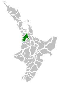
Waikato District is a territorial authority of New Zealand, in the northern part of Waikato Region, North Island. Waikato District is administered by the Waikato District Council, with headquarters in Ngaruawahia.
The district is centred to the north and west of the city of Hamilton, and takes in much of the northern Waikato Plains and also the Hakarimata Range. The north of the district contains swampy floodplain of the Waikato River and several small lakes, of which the largest is Lake Waikare.
Other than Ngaruawahia, the main population centres are Huntly, Raglan, and Te Kauwhata. The main industries in the district are dairy farming, forestry, and coal mining. There is a major coal-fired power station at Huntly. Te Kauwhata is at the centre of a major wine region.
Population
At the 2006 census the district had a population of 43,959. Of these, 6834 lived in Huntly, 5106 in Ngaruawahia, 2637 in Raglan, and 1294 in Te Kauwhata. In 2010, the district acquired part of the adjacent Franklin District, which was dissolved as part of the creation of the Auckland Council, increasing the area to 4,405 km2 (1,701 sq mi).[2] and adding the growing settlements of Tuakau and Pokeno (see table below). The district's population at the June 2018 Census was 75,300.[1]
The largest census areas[3] are shown in this table -
| Census area[2] | 2006 | 2013[4] |
|---|---|---|
| Waikato District | 43,959 | 63,381 |
| Huntly East | 3,909 | 4,119 |
| Huntly West | 2,928 | 2,835 |
| Tamahere-Tauwhare | 4,623 | 5,631 |
| Ngaruawahia | 5,106 | 5,127 |
| Tuakau | 3,501 | 4,182 |
| Waikato Western Hills | 3,786 | 3,978 |
| Onewhero | 3,771 | 3,831 |
| Kainui | 2,436 | 2,769 |
| Raglan | 2,637 | 2,736 |
| Waerenga | 1,788 | 2,535 |
| Whatawhata | 2,061 | 2,475 |
| Otaua | 2,166 | 2,268 |
| Eureka | 1,836 | 2,184 |
| Matangi | 1,791 | 2,157 |
| Whitikahu | 2,043 | 2,115 |
| Te Uku | 1,659 | 1,896 |
| Pokeno | 1,707 | 1,782 |
| Mangatawhiri | 1,380 | 1,533 |
| Te Kowhai | 1,278 | 1,512 |
| Te Kauwhata | 1,294 | 1,473 |
History
Under the Local Government (Waikato Region) Reorganisation Order 1989 nearly all of Waikato County Council was added to the Boroughs of Huntly, Ngaruawahia, most of Raglan County Council and a small part of Waipa County Council to form Waikato District Council.[5]
The County Councils had lasted over a hundred years from their formation in 1876. They had been preceded by Highways Boards, formed from 1866. Prior to that there had been many complaints about Auckland Province spending a disproportionate amount in Auckland. For example, in 1867 27 Raglan settlers petitioned the House of Representatives asking it to replace provinces with local government and saying that, out of a £500,000 loan to the province, only £500 was spent in all the country districts.[6]
Highways Boards
Auckland Province passed a Highways Act in 1862 allowing their Superintendent to define given areas of settlement as Highways Districts, each with a board of trustees elected by the landowners. Land within the boundaries of highway districts became subject to a rate of not more than 1/- an acre, or of 3d in the £ of its estimated sale value and that was to be equalled by a grant from the Province.[6]
By a notice in the Provincial Government Gazette on 25 August 1866, the deputy Superintendent, Daniel Pollen, declared Whaingaroa Highway District, the first in the future Raglan County. A public meeting in the Raglan courthouse on 20 October 1866 was followed by a meeting a week later to elect 5 trustees. The largest landowner in the district, Captain Johnstone, was elected chairman, but he and 3 other trustees resigned after they couldn't collect rates from absent owners and the Province didn't pay anything.[6]
Raglan Town Board was formed in 1868, Karioi Board in 1870 by division of Whaingaroa Highway District and by 1871 eleven board chairmen met in Ohaupo to ask for more government help. From 1872 government assistance more than matched rates collected; today government funding through NZTA mainly matches rates funding.[6]
Raglan County Council
Under the Counties Act, 1876, in a NZ Gazette Supplement of Thursday, December 28, 1876, the Governor General set the first county council meetings at noon, Raglan County's being in The Resident Magistrate's Court, Raglan on Tuesday, 9 January 1877.[6]
Raglan County was divided into five ridings (based on the distance a horse could travel in a day): Karioi, Pirongia, with 2 councillors each, and Te Akau, Onewhero and Whangape, with one. Only 3 of the Ridings were represented at the first meeting; W. H. Wallis (elected chairman) and John Pegler, Karioi Riding; James Sherrett, Pirongia; and Richard Robert Hunt, Onewhero. At the next meeting in Whatawhata there was only one other councillor present, from Pirongia. Many of the areas had not had Highway Boards and were sparsely populated (874 people in 175 houses across the whole county), so voters had problems getting together to nominate councillors. By 1887 there were 8 nominations for the 7 seats.[6]
As population grew the original 5 ridings were split - Karamu from Pirongia (28 November 1889), Whaingaroa from Karioi 1902, Pukekawa from Onewhero and Port Waikato from Te Akau 1911, Pukemiro from Whangape 1913 and Waingaro from Te Akau 1920.[6]
Some areas were transferred to neighbouring councils. The far south of Raglan went to Kawhia County when it was formed, but in 1952, the Local Government Commission put Makomako back in Raglan. On 1 October 1944, a coal-bearing area of Huntly West went to Huntly Borough. Other minor alterations were gazetted at intervals over the years. In 1954 a Raglan Town Committee was formed. Under the Local Government Act 1974, Raglan and Rotowaro became community towns, governed by elected councils.[6] Raglan had also had a Town Board from 1906 to 1938.[7]
The county relied on government grants until 1887, when government cuts forced it to set a rate. From 1889 to 1902 the Highways Boards were gradually merged into the County. Until 1943 each riding paid for its own roads and bridges, supplemented from council funds.[6]
The northern portion of Raglan County was added to Franklin District in 1989, when the rest joined WDC.[8]
References
- 1 2 "Subnational Population Estimates: At 30 June 2018 (provisional)". Statistics New Zealand. 23 October 2018. Retrieved 23 October 2018. For urban areas, "Subnational population estimates (UA, AU), by age and sex, at 30 June 1996, 2001, 2006-18 (2018 boundary)". Statistics New Zealand. 23 October 2018. Retrieved 23 October 2018.
- 1 2 StatsNZ interactive census boundaries map
- ↑ Census areas map - select area unit and type name
- ↑ QuickStats Waikato District 2013 census
- ↑ Te Ara maps of Waikato local government
- 1 2 3 4 5 6 7 8 9 C W Vennell & Susan Williams: Raglan County Hills and Sea 1876-1976
- ↑ Raglan Centennial booklet 1940
- ↑ "MANUKAU, PAPAKURA AND FRANKLIN ARCHIVES" (PDF). Auckland Regional Council.
External links
- Waikato District official website
- Hamilton & Waikato Regional Tourism
- Huntly Town
- The Cyclopedia of New Zealand – Raglan County in 1902
- 1906 Raglan County - Department of Lands and Survey maps - north and south
- 1921 Raglan County boundaries