Hurunui District
| Hurunui District | |
|---|---|
| Territorial authority | |
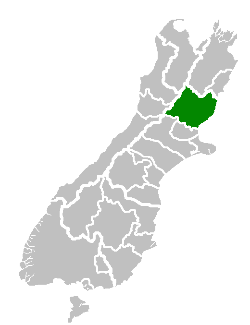 Location of the Hurunui District within the South Island | |
| Country | New Zealand |
| Region | Canterbury |
| District | Hurunui District Council |
| Wards |
Amberley Amuri-Hurunui Hanmer Springs Cheviot Glenmark |
| Formed | 1989 |
| Seat | Amberley |
| Government | |
| • Mayor | Winton Dalley |
| • Deputy Mayor | Marie Black |
| Area | |
| • Total | 8,660.43 km2 (3,343.81 sq mi) |
| Population (June 2017)[1] | |
| • Total | 12,800 |
| • Density | 1.5/km2 (3.8/sq mi) |
| Time zone | UTC+12 (NZST) |
| • Summer (DST) | UTC+13 (NZDT) |
| Postcode(s) | Map of postcodes |
| Website | Hurunui District Council |
Hurunui District is a political district on the east coast of New Zealand's South Island, north of Christchurch, New Zealand. It forms part of the Canterbury region and stretches from the east coast to the main divide. Its land area is 8,660.43 square kilometres (3,343.81 sq mi).
Population
The district had a usually resident population of 12,800 as of June 2017.[1] It also shares with the Waitaki District with the distinction of having the least number of non-European populations anywhere in New Zealand in both raw numbers and proportion, with over 95% of population recorded in the 2006 census as "European" or "New Zealanders" (which could be interpreted as mostly European according to antedocal evidence). Local populations could even recognise the identities of every local Maori or Asian recorded in the census.[2]
Local government
During the period, 1853 to 1876, the area north of the Hurunui River was administrated as part of the Nelson Province. After the abolition of the provinces in 1876 the Amuri and Cheviot counties were formed. In 1989, these counties were merged with the Ashley and Waipara counties to form the present district. The current district mayor is Winton Dalley, who was elected in 2010 upon the retirement of previous mayor Gary Jackson and reelected in the 2013 local government election after running unopposed.[3]
Populated places
Hurunui District consists of the following towns, localities, settlements and communities:
|
|
References
- 1 2 "Subnational Population Estimates: At 30 June 2017 (provisional)". Statistics New Zealand. 24 October 2017. Retrieved 24 October 2017. For urban areas, "Subnational population estimates (UA, AU), by age and sex, at 30 June 1996, 2001, 2006-16 (2017 boundary)". Statistics New Zealand. 24 October 2017. Retrieved 24 October 2017.
- ↑ "Our whitest region". New Zealand Herald. 2007-08-05. Retrieved 2009-02-16.
- ↑ "Election Results: Around the country". New Zealand Herald. 2013-10-12. Retrieved 2016-04-28.
External links
![]()
Coordinates: 43°9′7″S 172°43′44″E / 43.15194°S 172.72889°E