Geography of New Zealand
| Geography of New Zealand | |
 | |
| Continent | Zealandia |
| Region | Oceania |
| Coordinates | 41°S 174°E / 41°S 174°E |
| Area | Ranked 75th 267,710 km² 103,738 miles² 97.9% land 2.1% water |
| Coastline | 15,134 km 9,398 miles |
| Borders | 0 km |
| Highest point | Aoraki / Mount Cook 3,724 m (12,218 ft) |
| Lowest point | Taieri Plains −2 m |
| Longest river | Waikato River |
| Largest lake | Lake Taupo |
| Climate | Mostly temperate, with some areas being Tundra, and Subantarctic |
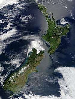
New Zealand (Aotearoa) is an island country located in the south-western Pacific Ocean, near the centre of the water hemisphere. It is a long and narrow country and comprises around 600 islands. The two main islands by size are the North Island (or Te Ika-a-Māui) and the South Island (or Te Waipounamu), separated by the Cook Strait; the third-largest island, Stewart Island (or Rakiura), is located 30 kilometres (19 mi) off the tip of the South Island across Foveaux Strait. Significantly smaller islands include Waiheke Island, Chatham Island, Great Barrier Island and more, although many are uninhabited.
New Zealand's landscape ranges from the fiord-like sounds of the southwest to the sandy beaches of the far north. The South Island is dominated by the Southern Alps while a volcanic plateau covers much of the central North Island. Temperatures rarely fall below 0 °C or rise above 30 °C and conditions vary from wet and cold on the South Island's West Coast to dry and continental a short distance away across the mountains and near subtropical in the northern reaches of the North Island.
New Zealand's varied landscape has appeared in television shows, such as Xena: Warrior Princess. An increasing number of feature films have also been filmed there, including the Lord of the Rings trilogy.
The country is situated about 2,000 kilometres (1,200 mi) southeast of Australia across the Tasman Sea, its closest neighbours to the north being Tonga and Fiji. It is the southernmost nation in Oceania. The relative proximity of New Zealand north of Antarctica has made the South Island a gateway for scientific expeditions to the continent.
Physical geography

Overview
New Zealand is located in the South Pacific Ocean at 41°S 174°E / 41°S 174°E, near the centre of the water hemisphere.[1] It is a long and narrow country, extending 1,600 kilometres (990 mi) along its north-north-east axis with a maximum width of 400 kilometres (250 mi).[2] New Zealand consists of a large number of islands, estimated around 600.[3] The islands give it 15,134 km (9,404 mi) of coastline and extensive marine resources. New Zealand claims the fifth-largest exclusive economic zone in the world, covering over 4,000,000 square kilometres (1,500,000 sq mi) (1.5 million sq mi), more than 15 times its land area.[4]
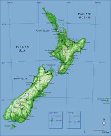
The South Island is the largest land mass of New Zealand, and is the 12th-largest island in the world. The island is divided along its length by the Southern Alps. The east side of the island has the Canterbury Plains while the West Coast is famous for its rough coastlines, very high proportion of native bush, and glaciers.[5]
The North Island is the second-largest island, and the 14th-largest in the world. It is separated from the South Island by the Cook Strait, with the shortest distance being 23 kilometres (14 mi).[6][7] The North Island is less mountainous than the South Island,[5] although a series of narrow mountain ranges form a roughly north-east belt that rises up to 1,700 metres (5,600 ft). Much of the surviving forest is located in this belt, and in other mountain areas and rolling hills.[8]
Besides the North and South Islands, the five largest inhabited islands are Stewart Island, Chatham Island, Great Barrier Island (in the Hauraki Gulf),[9] d'Urville Island (in the Marlborough Sounds)[10] and Waiheke Island (about 22 km (14 mi) from central Auckland).[11]
Land use
The country has a variety of natural resources, including:
- Geological: natural gas, iron ore, sand, coal, hydropower, gold, limestone
- Agricultural: dairy products, lamb and mutton, wheat, barley, potatoes, pulses, fruits, vegetables, wool, beef, fish[12]

New Zealand has a total land area of 267,710 square kilometres (103,360 sq mi) (including its outlying islands), making it slightly smaller than Italy and Japan and a little larger than the United Kingdom.[12] A relatively small proportion of New Zealand's land is arable (1.76%); permanent crops cover 0.27% of the land. 7,210 square kilometres (2,780 sq mi) of the land is irrigated. New Zealand has 327 cubic kilometres (78 cu mi) total renewable water resources.[12]
Mountain, volcanoes and glaciers
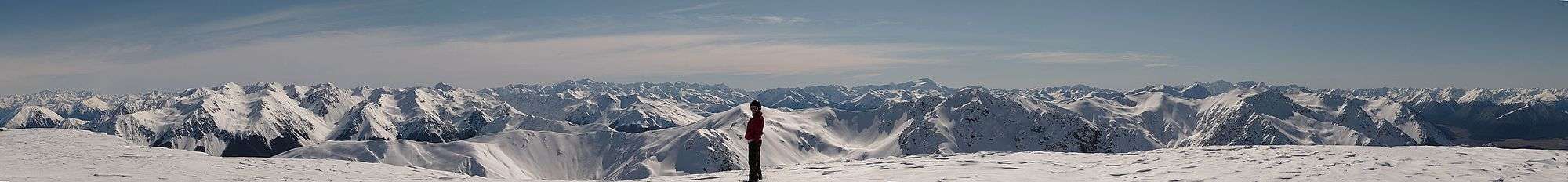
The South Island is much more mountainous than the North, but shows fewer manifestations of recent volcanic activity. There are 18 peaks of more than 3,000 metres (9,800 feet) in the Southern Alps, which stretch for 500 kilometres (310 mi) down the South Island.[13] The closest mountains surpassing it in elevation are found not in Australia, but in New Guinea and Antarctica. As well as the towering peaks, the Southern Alps include huge glaciers such as Franz Josef and Fox.[14] The country's highest mountain is Aoraki / Mount Cook; its height since 2014 is listed as 3,724 metres (12,218 feet) (down from 3,764 m (12,349 ft) before December 1991, due to a rockslide and subsequent erosion).[15] The second highest peak is Mount Tasman, with a height of 3,497 metres (11,473 ft).[16]
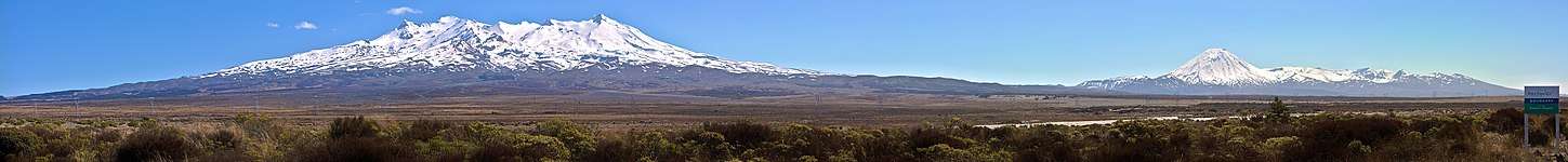
The North Island Volcanic Plateau covers much of central North Island with volcanoes, lava plateaus, and crater lakes. The three highest volcanoes are Mount Ruapehu (2,797 metres (9,177 ft)), Mount Taranaki (2,518 metres (8,261 ft)) and Mount Ngauruhoe (2,287 metres (7,503 ft)). Ruapehu's major eruptions have historically been about 50 years apart,[17] in 1895, 1945 and 1995–1996. The 1886 eruption of Mount Tarawera, located near Rotorua, was New Zealand's largest and deadliest eruption in the last 200 years, killing over 100 people.[18] Another long chain of mountains runs through the North Island, from Wellington to East Cape. The ranges include Tararua and Kaimanawa.[19]
The lower mountain slopes are covered in native forest. Above this are shrubs, and then tussock grasses. Alpine tundra consists of cushion plants and herbfields; many of these plants have white and yellow flowers.[20]
Rivers and lakes
The proportion of New Zealand's area (excluding estuaries) covered by rivers, lakes and ponds, based on figures from the New Zealand Land Cover Database,[21] is (357526 + 81936) / (26821559 – 92499–26033 – 19216) = 1.6%. If estuarine open water, mangroves, and herbaceous saline vegetation are included, the figure is 2.2%.

The mountainous areas of the North Island are cut by many rivers, many of which are swift and unnavigable. The east of the South Island is marked by wide, braided rivers such as the Wairau, Waimakariri and Rangitātā; formed from glaciers, they fan out into many strands on gravel plains. The Waikato, flowing through the North Island, is the New Zealand's longest river, with a length of 425 kilometres (264 mi).[22] New Zealand's rivers feature hundreds of waterfalls; the most visited set of waterfalls are the Huka Falls that drain Lake Taupo.[23]
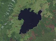
Lake Taupo, located near the centre of the North Island, is the largest lake by surface area in the country. It lies in a caldera created by the Oruanui eruption, the largest eruption in the world in the past 70,000 years. There are 3,820 lakes with a surface area larger than one hectare.[24] Many lakes have been used as reservoirs for hydroelectric projects.[25]
Caves
Throughout the Karst rocks many caves were formed, especially in the Waitomo District of the North Island.[26]
Extreme points

The phrase "From Cape Reinga to The Bluff" is frequently used within New Zealand to refer to the extent of the whole country.[27] Cape Reinga is northwesternmost tip of the Aupouri Peninsula, at the northern end of the North Island. Bluff is Invercargill's port, located near the southern tip of the South Island, below the 46th parallel south. However, the extreme points of New Zealand are actually located in several outlying islands.[28]
The points that are farther north, south, east or west than any other location in New Zealand are as follows:[28]
- The northernmost point is in Nugent Island in the Kermadec Islands (29°13′54″S 177°52′09″W / 29.231667°S 177.869167°W).
- The southernmost point is Jacquemart Island in the Campbell Island group (52°37′10″N 169°07′33″E / 52.619444°N 169.125833°E).
- The easternmost point is situated in a group of islands within the Chatham Islands called the Forty-Fours (43°57′48″S 175°49′53″W / 43.963306°S 175.831410°W).
- The westernmost point is Cape Lovitt on Auckland Island (50°47′59″S 165°52′12″E / 50.799838°S 165.870128°E).
Geology

Data source: Institute of Geological and Nuclear Sciences
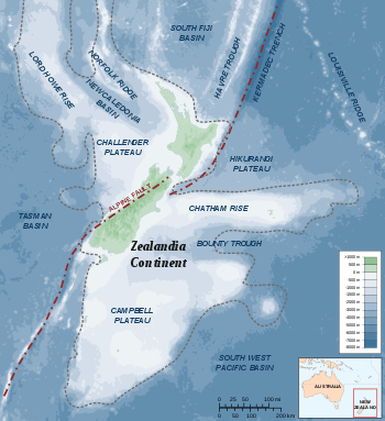
New Zealand is part of Zealandia, a microcontinent nearly half the size of Australia that gradually submerged after breaking away from the Gondwanan supercontinent.[29] Zealandia extends a significant distance east into the Pacific Ocean and south towards Antarctica. It also extends towards Australia in the north-west. This submerged continent is dotted with topographic highs that sometimes form islands. Some of these, such as the main islands (North and South), Stewart Island, and the Chatham Islands, are settled. Other smaller islands are eco-sanctuaries with carefully controlled access.
The New Zealand landmass has been uplifted due to transpressional tectonics between the Indo-Australian Plate and Pacific plates (these two plates are grinding together with one riding up and over the other).[30] The associated geothermal energy is used in numerous hydrothermal power plants.[31] Some volcanic places are also famous tourist destinations, such as the Rotorua geysers.[32]
To the east of the North Island the Pacific Plate is forced under the Indo-Australian Plate. The North Island of New Zealand has widespread back-arc volcanism as a result of this subduction. There are many large volcanoes with relatively frequent eruptions. There are also several very large calderas, with the most obvious forming Lake Taupo. Taupo has a history of incredibly powerful eruptions, with the Oruanui eruption approx. 26,500 years ago ejecting 1,170 cubic kilometres (280 cu mi) of material and causing the downward collapse of several hundred square kilometers to form the lake.[33] The last eruption occurred c. 180 CE and ejected at least 100 cubic kilometers of material, and has been correlated with red skies seen at the time in Rome and China.[34]
The subduction direction is reversed through the South Island, with the Indo-Australian Plate forced under the Pacific Plate. The transition between these two different styles of continental collision occurs through the top of the South Island. This area has significant uplift and many active faults; large earthquakes are frequent occurrences here. The most powerful in recent history, the M8.3 Wairarapa earthquake, occurred in 1855. This earthquake generated more than 6 metres (20 ft) of vertical uplift in places, and caused a localised tsunami. Fortunately casualties were low due to the sparse settlement of the region. In 2013, the area was rattled by the M6.5 Seddon earthquake, but this caused little damage and no injuries.[35] New Zealand's capital city, Wellington, is situated in the centre of this region.
The subduction of the Indo-Australian Plate drives rapid uplift in the centre of the South Island (approx. 10 millimetres (0.39 in) per year). This uplift forms the Southern Alps. These roughly divide the island, with a narrow wet strip to the west and wide and dry plains to the east. The resulting orographic rainfall enables the hydroelectric generation of most of the country's electricity.[25] A significant amount of the movement between the two plates is accommodated by lateral sliding of the Indo-Australian Plate north relative to the Pacific Plate. The plate boundary forms the nearly 800 kilometres (500 mi) long Alpine Fault. This fault has an estimated rupture reoccurrence interval of ~330 years, and last ruptured in 1717 along 400 kilometres (250 mi) of its length. It passes directly under many settlements on the West Coast of the South Island and shaking from a rupture would likely affect many cities and towns throughout the country.
The rapid uplift and high erosion rates within the Southern Alps combine to expose high grade greenschist to amphibolite facies rocks, including the gemstone pounamu (jadeite). Geologists visiting the West Coast can easily access high-grade metamorphic rocks and mylonites associated with the Alpine Fault, and in certain places can stand astride the fault trace of an active plate boundary.[36]
To the south of New Zealand the Indo-Australian Plate is subducting under the Pacific Plate, and this is beginning to result in back-arc volcanism. The youngest (geologically speaking) volcanism in the South Island occurred in this region, forming the Solander Islands (<2 million years old). This region is dominated by the rugged and relatively untouched Fiordland, an area of flooded glacially carved valleys with little human settlement.
Human geography

Political geography
New Zealand has no land borders.[12] However, the Ross Dependency, its claim in Antarctica, nominally borders the Australian Antarctic Territory to the west and unclaimed territory to the east. Most other countries do not recognise territorial claims in Antarctica.[37]
New Zealand proper is subdivided into sixteen regions: seven in the South Island and nine in the North.[38] They have a geographical link with regional boundaries being based largely on drainage basins.[39] Among the regions, eleven are administered by regional authorities (top tier of local government), while five are unitary authorities that combine the functions of regional authorities and those of territorial authorities (second tier). Regional authorities are primarily responsible for environmental resource management, land management, regional transport, and biosecurity and pest management. Territorial authorities administer local roading and reserves, waste management, building consents, the land use and subdivision aspects of resource management, and other local matters.[39]
The Chatham Islands is not a region, although its council operates as a region under the Resource Management Act. There are a number of outlying islands that are not included within regional boundaries. The Kermadecs and the subantarctic islands are inhabited only by a small number of Department of Conservation staff.[40]
Population geography
The South Island contains a little under one-quarter of the population. Over three-quarters of New Zealands population live in the North Island, with one-third of the total population living in the Auckland Region. Auckland is also the fastest growing region, accounting for 46 percent of New Zealand's total population growth. Most Māori live in the North Island (87 percent), although a little under a quarter (24 percent) live in Auckland. New Zealand is a predominantly urban country, with 86.5 percent of the population living in an urban area. About 73.0 percent of the population live in the 17 main urban areas (population of 30,000 or more) and 53.8 percent live in the four largest cities of Auckland, Christchurch, Wellington, and Hamilton.[41]
Climate

The main factors that influence New Zealand's climate are similar to those found in the British Isles—the temperate latitude, with prevailing westerly winds; the oceanic environment; and the mountains, especially the Southern Alps. The climate is mostly temperate with mean temperatures ranging from 8 °C (46 °F) in the South Island to 16 °C (61 °F) in the North Island.[42] January and February are the warmest months, July the coldest. New Zealand does not have a large temperature range, apart from central Otago, but the weather can change rapidly and unexpectedly. Near subtropical conditions are experienced in Northland.
Most settled, lowland areas of the country have between 600 and 1600 mm of rainfall, with the most rain along the west coast of the South Island and the least on the east coast of the South Island and interior basins, predominantly on the Canterbury Plains and the Central Otago Basin (about 350 mm PA). Christchurch is the driest city, receiving about 640 mm (25 in) of rain per year, while Hamilton is the wettest, receiving more than twice that amount at 1325 mm PA, followed closely by Auckland. The wettest area by far is the rugged Fiordland region, in the south-west of the South Island, which has between 5000 and 8000 mm of rain per year, with up to 15,000 mm in isolated valleys, amongst the highest recorded rainfalls in the world.[43]

The UV index can be very high and extreme in the hottest times of the year in the north of the North Island. This is partly due to the country's relatively little air pollution compared to many other countries and the high sunshine hours. New Zealand has very high sunshine hours with most areas receiving over 2000 hours per year. The sunniest areas are Nelson/Marlborough and the Bay of Plenty with 2400 hours per year.[44]
Natural hazards
Flooding is the most regular natural hazard.[45] Few regions have escaped winter floods. Settlements are usually close to hill-country areas which experience much higher rainfall than the lowlands due to the orographic effect. Mountain streams which feed the major rivers rise rapidly and frequently break their banks covering farms with water and silt. Close monitoring, excellent weather forecasting, stopbanks, multiple hydropower dams, river dredging and reafforestation programmes in hill country have ameliorated the worst effects.
New Zealand experiences around 14,000 earthquakes a year,[46] some in excess of magnitude 7 (M7). Since the 2010, several large (M7, M6.3, M6.4, M6.2) and shallow (all <7 km) earthquakes have occurred immediately beneath Christchurch.[47] These have resulted in 185 deaths, widespread destruction of buildings and significant liquefaction.[48] These earthquakes are releasing distributed stress in the Pacific plate from the ongoing collision with the Indo-Australian plate to the west and north of the city. Volcanic activity is most common on the central North Island Volcanic Plateau. Tsunamis affecting New Zealand are associated with the Pacific Ring of Fire.[49]
Droughts are not regular and occur mainly in Otago and the Canterbury Plains and less frequently over much of the North Island between January and April. Forest fires were rare in New Zealand before the arrival of humans.[50] Fire bans exist in some areas in summer.[51]
Environment and ecology
New Zealand's geographic isolation for 80 million years[52] and island biogeography has influenced evolution of the country's species of animals, fungi and plants. Physical isolation has not caused biological isolation, and this has resulted in a dynamic evolutionary ecology with examples of very distinctive plants and animals as well as populations of widespread species.[53][54] Evergreens such as the giant kauri and southern beech dominate the forests. It also has a diverse range of birds, several of which are flightless such as the kiwi (a national icon), the kakapo, the takahē and the weka,[55] and several species of penguins.[56] Around 30 bird species are currently listed as endangered or critically endangered.[57] Conservationists recognised that threatened bird populations could be saved on offshore islands, where, once predators were exterminated, bird life flourished again.
Many bird species, including the giant moa, became extinct after the arrival of Polynesians, who brought dogs and rats, and Europeans, who introduced additional dog and rat species, as well as cats, pigs, ferrets, and weasels.[58] Native flora and fauna continue to be hard-hit by invasive species. New Zealand conservationists have pioneered several methods to help threatened wildlife recover, including island sanctuaries, pest control, wildlife translocation, fostering, and ecological restoration of islands and other selected areas.[59]
Massive deforestation occurred after humans arrived,[60] with around half the forest cover lost to fire after Polynesian settlement.[61] Much of the remaining forest fell after European settlement, being logged or cleared to make room for pastoral farming, leaving forest occupying only 23% of the land.[62]
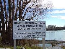
Pollution, particularly water pollution, is one of New Zealand's most significant environmental issues. Fresh water quality is under pressure from agriculture, hydropower, urban development, pest invasions and climate change,[63] although much of the country's household and industrial waste is now increasingly filtered and sometimes recycled.

Protected areas
Some areas of land, the sea, rivers or lakes are protected by law, so their special plants, animals, landforms and other features are safe from harm. New Zealand has three World Heritage Sites,[64] 13 national parks, 34 marine reserves, and thousands of scenic, historic, recreation and other reserves.[65] The Department of Conservation is responsible for managing 8.5 million hectares of public land (approximately 30% of New Zealand's landmass).[66]
Environmental agreements
New Zealand is party to several multilateral environmental agreements.[67] The major agreements are listed below.
Antipodes

New Zealand proper is largely antipodal to the Iberian Peninsula of Europe.[68] The northern half of the South Island corresponds to Galicia and northern Portugal.[68] Christchurch, in the South Island, is one of very few cities in the world that have near-exact antipodal cities, with A Coruña, Galicia, as Christchurch's antipode. Most of the North Island corresponds to central and southern Spain, from Valladolid (opposite the southern point of the North Island, Cape Palliser), through Madrid and Toledo to Cordoba (directly antipodal to Hamilton), Lorca (opposite East Cape), Málaga (Cape Colville), and Gibraltar. Parts of the Northland Peninsula oppose Morocco, with Whangarei nearly coincident with Tangiers. The antipodes of the Chatham Islands lie in France, just north of the city of Montpellier.[68] The Antipodes Islands were named for their supposed antipodal position to Britain; although they are the closest land to the true antipodes of Britain, their location 49°41′S 178°48′E is directly antipodal to a point a few kilometres to the east of Cherbourg on the north coast of France.[69]
In Europe the term "Antipodes" is often used to refer to New Zealand and Australia (and sometimes other South Pacific areas),[70] and "Antipodeans" to their inhabitants.
References
- ↑ Hobbs, Joseph J. (2008). World Regional Geography. Cengage Learning. p. 9. ISBN 0495389501. Retrieved 16 August 2017.
- ↑ McKenzie, D. W. (1987). Heinemann New Zealand atlas. Heinemann Publishers. ISBN 0-7900-0187-X.
- ↑ McSaveney, Eileen (24 September 2007). "Nearshore islands". Te Ara: The Encyclopedia of New Zealand.
- ↑ Ministry for the Environment. 2005. Offshore Options: Managing Environmental Effects in New Zealand's Exclusive Economic Zone. Introduction
- 1 2 McSaveney, Eileen. "Landscapes – overview". Te Ara: The Encyclopedia of New Zealand. Retrieved 11 June 2018.
- ↑ McLintock, A. H. (1966), "Cook Strait - The Sea Floor", An Encyclopaedia of New Zealand
- ↑ The Editors of Encyclopaedia Britannica. "Cook Strait | strait, New Zealand". Encyclopedia Britannica. Retrieved 9 October 2018.
- ↑ Walrond, Carl (February 2005). "Natural environment – The bush and its plants". Te Ara: The Encyclopedia of New Zealand. Retrieved 15 August 2017.
- ↑ "Hauraki Gulf islands". Auckland City Council. Archived from the original on 25 December 2010. Retrieved 13 January 2011.
- ↑ Hindmarsh (2006). "Discovering D'Urville". Heritage New Zealand. Archived from the original on 11 May 2011. Retrieved 13 January 2011.
- ↑ "Distance tables". Auckland Coastguard. Archived from the original on 23 January 2011. Retrieved 2 March 2011.
- 1 2 3 4 "The World Factbook". Central Intelligence Agency. 2015. p. 537–542. ISBN 9780160925535.
- ↑ Kisch, Conrad (2009). Destination. New Zealand. Gyldendal Uddannelse. p. 11. ISBN 9788702075847.
- ↑ McSaveney, Eileen (24 September 2007). "Glaciers and glaciation". Te Ara: The Encyclopedia of New Zelaand. Retrieved 11 June 2018.
- ↑ "Aoraki/Mt Cook shrinks by 30m". Stuff.co.nz. 16 January 2014.
- ↑ Dennis, Andy (2 February 2017). "Mountains - South Island mountains". Te Ara: The Encyclopedia of New Zealand. Retrieved 11 June 2018.
- ↑ New Zealand Department of Conservation. "Crater Lake". Retrieved 2006-10-23.
- ↑ "Eruption of Mt Tarawera". Ministry for Culture and Heritage. Retrieved 21 August 2017.
- ↑ Dennis, Andy (2 February 2017). "Mountains". Te Ara: The Encyclopedia of New Zealand. Retrieved 11 June 2018.
- ↑ Dennis, Andy (2 February 2017). "Mountains - Alpine plants and animals". Te Ara: The Encyclopedia of New Zealand. Retrieved 11 June 2018.
- ↑ "Historical environmental reporting". Ministry for the Environment of New Zealand. 2007. Retrieved 21 November 2016.
- ↑ Young, David (24 September 2007). "Rivers". Te Ara: The Encyclopedia of New Zealand. Retrieved 16 August 2017.
- ↑ Phillips, Jock (24 September 2007). "Waterfalls". Te Ara: The Encyclopedia of New Zealand. Retrieved 11 June 2018.
- ↑ "List of lakes of New Zealand". TheGrid. 12 February 2014. Retrieved 21 November 2016.
- 1 2 About 58% of New Zealand's electricity was hydroelectric in 2002. Veronika Meduna. 'Wind and solar power Archived 19 August 2007 at the Wayback Machine.', Te Ara – the Encyclopedia of New Zealand, updated 21 September 2007.
- ↑ "Things to see and do in Waitomo Caves, New Zealand". www.newzealand.com. Tourism New Zealand. Retrieved 16 August 2017.
- ↑ Bennett, Joe (2005). A Land of Two Halves. Simon and Schuster. p. 59. ISBN 9780743263573.
- 1 2 "The Extreme Points Of New Zealand". 29 March 2018. Retrieved 11 June 2018.
- ↑ Wallis, G. P.; Trewick, S. A. (2009). "New Zealand phylogeography: evolution on a small continent". Molecular Ecology. 18 (17): 3548–3580. doi:10.1111/j.1365-294X.2009.04294.x. PMID 19674312.
- ↑ Lewis, Keith; Nodder, Scott; Carter, Lionel (March 2009). "Sea floor geology – Active plate boundaries". Te Ara: The Encyclopedia of New Zealand. Retrieved 14 August 2017.
- ↑ Matthew Hall (2004) Existing and Potential Geothermal Resource for Electricity Generation. Ministry for Economic Development.
- ↑ "Rotorua Geothermal Sites – Geothermal Sites in Rotorua New Zealand". New Zealand on the Web. Retrieved 15 August 2017.
- ↑ "The Power of Taupo". www.nzgeo.com. New Zealand Geographic. Retrieved 15 August 2017.
- ↑ Wilson, C. J. N.; Ambraseys, N. N.; Bradley, J.; Walker, G. P. L. (1980). "A new date for the Taupo eruption, New Zealand". Nature. 288 (5788): 252–253. Bibcode:1980Natur.288..252W. doi:10.1038/288252a0.
- ↑ "M 6.5 Cook Strait Sun, Jul 21 2013". GeoNet. Retrieved 15 August 2017.
A magnitude 6.5 earthquake occurred 20 km east of Seddon, New Zealand on Sun Jul 21 2013 5:09 PM
- ↑ COOPER, A. F. (1 October 1972). "Progressive Metamorphism of Metabasic Rocks from the Haast Schist Group of Southern New Zealand". Journal of Petrology. pp. 457–492. Bibcode:1972JPet...13..457C. doi:10.1093/petrology/13.3.457. Retrieved 15 August 2017.
- ↑ "Who owns Antarctica?". Australian Department of the Environment and Energy. 8 September 2017. Retrieved 10 October 2018.
- ↑ "New Zealand – A regional profile". Statistics New Zealand. Retrieved 15 August 2017.
- 1 2 OECD Territorial Reviews OECD Territorial Reviews: The Metropolitan Region of Rotterdam-The Hague, Netherlands. OECD Publishing. 2016. p. 169. ISBN 9789264249387.
- ↑ "NZ Outlying Islands Regional Information & Travel Information". www.tourism.net.nz. New Zealand Tourism Guide. Retrieved 23 August 2017.
- ↑ "Subnational Population Estimates: At 30 June 2017 (provisional)". Statistics New Zealand. 24 October 2017. Retrieved 24 October 2017. For urban areas, "Subnational population estimates (UA, AU), by age and sex, at 30 June 1996, 2001, 2006-16 (2017 boundary)". Statistics New Zealand. 24 October 2017. Retrieved 24 October 2017.
- ↑ From NIWA Science climate overview.
- ↑ "Mean monthly rainfall". National Institute of Water and Atmospheric Research. Archived from the original (XLS) on 3 May 2011. Retrieved 4 February 2011.
- ↑ "Mean monthly sunshine hours". National Institute of Water and Atmospheric Research. Archived from the original (XLS) on 15 October 2008. Retrieved 16 August 2017.
- ↑ McSaveney, Eileen (1 August 2017). "Floods – New Zealand's number one hazard". Te Ara: The Encyclopedia of New Zealand. Retrieved 16 August 2017.
- ↑ Radio NZ news Archived 27 January 2012 at the Wayback Machine. report on 2007 Gisborne earthquake
- ↑ Nicholls, Paul. "Christchurch Quake Map – Earthquakes since September 4 2010". www.christchurchquakemap.co.nz. Retrieved 15 August 2017.
- ↑ "Christchurch earthquake kills 185: 22 February 2011". Ministry for Culture and Heritage. 12 April 2017. Retrieved 15 August 2017.
- ↑ "Volcanoes - Pacific Ring of Fire". Te Ara: The Encyclopedia of New Zealand. Retrieved 11 June 2018.
- ↑ Dennys Guild; Murray Dudfield (2009), "A history of fire in the forest and rural landscape in New Zealand Part 1, pre-Maori and pre-European influences" (PDF), New Zealand Institute of Forestry, retrieved 16 August 2017
- ↑ "Fire management". www.doc.govt.nz. New Zealand Department of Conservation. Retrieved 16 August 2017.
- ↑ Cooper, R.; Millener, P. (1993). "The New Zealand biota: Historical background and new research". Trends in Ecology & Evolution. 8 (12): 429. doi:10.1016/0169-5347(93)90004-9.
- ↑ Trewick SA, Morgan-Richards M. 2014. New Zealand Wild Life. Penguin, New Zealand. ISBN 9780143568896
- ↑ Lindsey, Terence; Morris, Rod (2000). Collins Field Guide to New Zealand Wildlife. HarperCollins (New Zealand) Limited. p. 14. ISBN 978-1-86950-300-0.
- ↑ Wilson, Kerry-Jayne (24 September 2007). "Land birds – overview". Te Ara: The Encyclopedia of New Zealand. Retrieved 16 August 2017.
- ↑ "Penguins". www.doc.govt.nz. New Zealand Department of Conservation. Retrieved 16 August 2017.
- ↑ "New Zealand's threatened birds". www.doc.govt.nz. New Zealand Department of Conservation. Retrieved 16 August 2017.
- ↑ Holdaway, Richard (24 September 2007). "Extinctions – New Zealand extinctions since human arrival". Te Ara: The Encyclopedia of New Zealand. Retrieved 16 August 2017.
- ↑ Jones, Carl (2002). "Reptiles and Amphibians". In Perrow, Martin; Davy, Anthony. Handbook of ecological restoration: Principles of Restoration. 2. Cambridge University Press. p. 362. ISBN 0-521-79128-6.
- ↑ Swarbrick, Nancy (24 September 2007). "Logging native forests'". Te Ara: The Encyclopedia of New Zealand. Retrieved 16 August 2017.
- ↑ McGlone, M.S. (1989). "The Polynesian settlement of New Zealand in relation to environmental and biotic changes" (PDF). New Zealand Journal of Ecology. 12(S): 115–129. Archived from the original (PDF) on 17 July 2014.
- ↑ Taylor, R. and Smith, I. (1997). The state of New Zealand’s environment 1997. Ministry for the Environment, Wellington.
- ↑ Gluckman, Sir Peter (12 April 2017). "New Zealand's Fresh Waters" (PDF). Prime Minister’s Chief Science Advisor.
- ↑ "New Zealand". whc.unesco.org. UNESCO World Heritage Centre. Retrieved 23 August 2017.
- ↑ Molloy, Les (September 2015). "Protected areas". Te Ara: The Encyclopedia of New Zealand. Retrieved 23 August 2017.
- ↑ "New Zealand - Country Profile". Convention on Biological Diversity. UN. Retrieved 23 August 2017.
- ↑ "Multilateral environmental agreements". www.mfe.govt.nz. Ministry for the Environment. Retrieved 24 August 2017.
- 1 2 3 "Antipodes Map – Tunnel to the other side of the world". www.antipodesmap.com. Retrieved 16 August 2017.
- ↑ "Antipodes Islands". Twelve Mile Circle. Retrieved 6 January 2011.
- ↑ Goldie, Matthew Boyd (2010). The Idea of the Antipodes: Place, People, and Voices. Routledge. p. 165. ISBN 9781135272180.
External links
| Wikimedia Commons has media related to Geography of New Zealand. |
- Statistics New Zealand
- New Zealand profile at World Atlas
- Natural Environment – Te Ara Encyclopedia of New Zealand
- New Zealand's Geological History – 1966 Encyclopaedia of New Zealand
![]()