Otorohanga District
| Otorohanga District | |
|---|---|
| Territorial authority | |
 | |
| Country | New Zealand |
| Region | Waikato |
| District | Otorohanga District Council |
| Wards |
Kawhia-Tihiroa Waipa Wharepuhunga Kiokio-Korakonui Otorohanga |
| Formed | 1979 |
| Seat | Otorohanga |
| Government | |
| • Mayor | Max Baxter |
| • Deputy Mayor | Deborah Pilkington |
| Area | |
| • Total | 1,976 km2 (763 sq mi) |
| Population (June 2017)[1] | |
| • Total | 10,100 |
| • Density | 5.1/km2 (13/sq mi) |
| Time zone | UTC+12 (NZST) |
| • Summer (DST) | UTC+13 (NZDT) |
| Postcode(s) | Map of postcodes |
| Website | Otorohanga District |
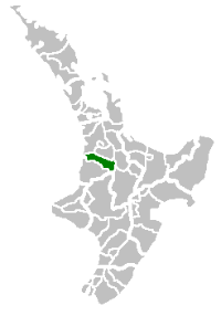
Otorohanga District is a municipality in the Waikato region of the North Island of New Zealand. It was formed in 1979 by renaming Otorohanga County. Max Baxter has been the mayor of Otorohanga District since 2013.
Geography
Otorohanga District is located south of Hamilton, west of Rotorua, and northwest of Taupo. Adjacent districts are (clockwise from the north) Waikato, Waipa, South Waikato, Taupo, and Waitomo. The seat of the district council is in the town of Otorohanga.
The district's population at the June 2017 was 10,100,[1] with Otorohanga being the main centre. Other places in the district include Oparau, Hauturu, Owhiro, Honikiwi, Puketotara, Te Kawa, Otewa, Maihiihi, Wharepuhunga, and Kawhia.[2] The district has a land area of 1,976 square kilometres (763 sq mi).[3] Otorohanga is the gateway to the Waitomo Caves, which is located 15 minutes away.[3]
History
After the land wars, the wider area of the King Country was a refuge for Tāwhiao, the second Māori King, and his followers. From 1864 to 1883, pākehā (white settlers) were not allowed into the area unless they had express permission. The district was used for farming from the late 19th century onwards. The first municipal government, Otorohanga County, was formed in 1922. In 1956, the northern part of Kawhia County and Otorohanga County were amalgamated. On 1 November 1971, Otorohanga Borough was subsumed into Otorohanga County. The Otorohanga District was declared in 1979 by renaming Otorohanga County.[3]
Governance
The district council is headed by a mayor, and complemented by seven councillors from five wards. The council wards are Kawhia/Tihiroa (two councillors), Waipa, Wharepuhunga, Kiokio/ Korakonui, and Otorohanga (two councillors).[4] The current mayor is Max Baxter, who in the 2013 local elections succeeded Dale Williams.[5]
References
- 1 2 "Subnational Population Estimates: At 30 June 2017 (provisional)". Statistics New Zealand. 24 October 2017. Retrieved 24 October 2017. For urban areas, "Subnational population estimates (UA, AU), by age and sex, at 30 June 1996, 2001, 2006-16 (2017 boundary)". Statistics New Zealand. 24 October 2017. Retrieved 24 October 2017.
- ↑ Quickstats about Otorohanga District
- 1 2 3 "About the District". Otorohanga District Council. Archived from the original on 9 June 2016. Retrieved 4 July 2015.
- ↑ "Otorohanga District Council Elected Members". Otorohanga District Council. Archived from the original on 9 June 2016. Retrieved 4 July 2015.
- ↑ Leaman, Aaron (14 October 2013). "Business as usual as Baxter takes charge". Waikato Times. Retrieved 4 July 2015.