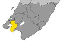
Lower Hutt
| Lower Hutt Awakairangi (Māori) | |
|---|---|
 | |
| Coordinates: 41°13′S 174°55′E / 41.217°S 174.917°E | |
| Country |
|
| Region | Wellington |
| Territorial authority | Hutt City |
| Suburbs |
Petone Melling Maungaraki Normandale Kelson Belmont Ava Alicetown Moera Woburn Waiwhetū Waterloo Taita Seaview Avalon Stokes Valley Wainuiomata Eastbourne Fairfield Epuni Boulcott |
| Government | |
| • Mayor | Ray Wallace |
| Area | |
| • Territorial | 377 km2 (146 sq mi) |
| • Urban | 135 km2 (52 sq mi) |
| Population (June 2017)[1] | |
| • Territorial | 104,700 |
| • Density | 280/km2 (720/sq mi) |
| • Urban | 104,100 |
| • Urban density | 770/km2 (2,000/sq mi) |
| Postcode(s) | 5010, 5011, 5012, 5013, 5014, 5019 |
| Area code(s) | 04 |
| Website |
huttcity |
Lower Hutt (Māori: Awakairangi) is a city in the Wellington Region of the North Island of New Zealand. It is administered by the Hutt City Council and is one of the four cities that constitute the Wellington metropolitan area.
It is New Zealand's seventh most populous city, with a population of 104,700.[1] The total area administered by the Council is 377 km2 (146 sq mi) around the lower half of the Hutt Valley and the eastern shores of Wellington Harbour, of which 135 km2 (52 sq mi) is urban. It is separated from Wellington proper by the harbour, and from Upper Hutt by the Taitā Gorge.
Though it is administered by the Hutt City Council, neither the New Zealand Geographic Board nor the Local Government Act recognise the name Hutt City. This name has led to confusion, as Upper Hutt is administered by a separate city council, the Upper Hutt City Council, which objects to the name "Hutt City".
History
Before European settlement, thick forest covered most of the Hutt Valley, with areas of marshland close to the river's mouth. Māori inhabited the shoreline, with a pa at each end of Petone beach.
The local Māori welcomed the arrival of the New Zealand Company ship Tory in 1839, and William Wakefield (the company's agent) negotiated with local chiefs to allow settlement. The first immigrant ship, the Aurora, arrived on 22 January 1840, still celebrated every year on the Monday closest as Wellington's Anniversary Day. A settlement, Britannia, grew up close to the mouth of the Hutt River, and settlers set up the infant country's first newspaper and bank.
The city takes its name from the river, named after the founding member, director and chairman of the New Zealand Company, Sir William Hutt.
Within months of settlement the river flooded, and in March 1840 the majority of Britannia settlers decided to move to Thorndon, (as of 2013 in the heart of Wellington city), though some settlers remained at the north end of the harbour. In the 1840s an area on the west bank of the Hutt River formed the village then known as Aglionby.[2]
In 1846 conflict arose between settlers and Māori, which led to skirmishes in the Hutt Valley Campaign.
The 1855 Wairarapa earthquake (in the range 8.1–8.3) raised part of the lower valley, allowing reclamation of land from swamp. The fault escarpment from the earthquake is still visible, notably at Hutt Central School.
On New Year's Day 1859 the first permanent lighthouse to be built in New Zealand was lit at Pencarrow Head, and was home to New Zealand's only female lighthouse keeper, Mary Jane Bennett, was the inaugural operator of the lighthouse.[3]
The railway line from central Wellington reached Lower Hutt station (now Western Hutt) in April 1874, with the line travelling north up the west side of the river to Silverstream opening two years later.
Before the Second World War, urban settlement in the lower Hutt Valley concentrated mainly on Petone, central Lower Hutt and Eastbourne, with a total population of 30,000. In 1927 the Public Works Department completed the construction of a branch railway line to Waterloo on the east side of the river; the route diverging from the main line between Lower Hutt and Petone. Two years later the railway workshops moved from Petone to a new larger site off the new branch at Woburn.
In the late 1940s new suburbs of state housing developed along the eastern side of the Hutt Valley, from Waiwhetu to Taita, to alleviate nationwide housing shortages and to cater for the booming population. Between 1946 and 1954, the railway line from Waterloo was extended through these new suburbs to Haywards, becoming the main line in 1954 when the existing main line was closed between Haywards and Melling. By the end of the 1950s, Lower Hutt had a population of 80,000.
Government
Local
The Hutt City Council is made up of a mayor and 12 councillors. Ray Wallace was elected Lower Hutt mayor in 2010, succeeding David Ogden. The city's six electoral wards (Northern, Western, Central, Eastern, Harbour and Wainuiomata) each elect two councillors.
| Name | Affiliation (if any) | Notes | |
|---|---|---|---|
| Ray Wallace | Independent | Mayor of Lower Hutt | |
| Glenda Barratt | Independent | Ward: Eastern | |
| David Bassett | Independent | Ward: Central | |
| Campbell Barry | Independent | Ward: Wainuiomata | |
| Lisa Bridson | Green Party | Ward: Eastern | |
| Josh Briggs | Independent | Ward: Wainuomata | |
| Margaret Cousins | Independent | Ward: Western | |
| Simon Edwards | Independent | Ward: Central | |
| Tui Lewis | Independent | Ward: Harbour | |
| Michael Lulich | Independent | Ward: Harbour | |
| Gwen McDonald | Independent | Ward: Northern | |
| Chris Milne | The Man with a Plan | Ward: Western | |
| Leigh Sutton | Independent | Ward: Northern |
- Wainuiomata Community Board: Richard Sinnott (Independent – Chair), Gabriel Tupou (Independent – Deputy Chair), Jodie Winterburn (Independent), Keri Brown (Labour), Terry Stallworth (Independent), Sisi Tuala-Le'afa (Independent), councilors Campbell Barry and Josh Briggs.
- Eastbourne Community Board: Virginia Horrocks (Independent – Chair), Murray Gibbons (Independent – Deputy Chair), Robert Ashe (Green Party), Liz Knight (Independent), Anna Sutherland (Independent), councilors Michael Lulich and Tui Lewis.
- Petone Community Board: Pam Hanna (Chair – Independent), Mike Fisher (Deputy Chair – Independent), Mason Branch (Independent), Brady Dyer (Independent), Peter Foaese (Independent), Karen Yung (Independent), councilors Michael Lulich and Tui Lewis.
Neighbouring councils are Wellington City Council (adjoining to the north-west), Porirua City Council to the north, Upper Hutt City Council to the north-east and South Wairarapa District Council to the east. The boundaries of the Lower Hutt city local body have evolved from a series of amalgamations and boundary changes over the years.
The Hutt County Council was established in 1877 and covered the region from Wellington's south coast up to Waikanae, excluding the Wellington City Council area. As the region grew, urban parts of the Hutt county became autonomous boroughs: Petone in 1888, Lower Hutt in 1891, Eastbourne in 1906, Johnsonville in 1908, Upper Hutt in 1908, Porirua in 1962 and Kapiti in 1974.
In 1941 Lower Hutt became a city. It incorporated Normandale in 1957.
In 1987/1989 the New Zealand Government forced local authorities to consolidate, which led to Lower Hutt amalgamating with the adjacent Boroughs of Petone and Eastbourne and with the Wainuiomata District (which had its independence for barely a year), and to the abolition of the Hutt County Council.
National
Lower Hutt is covered by two general electorates, Hutt South and Rimutaka and two Māori electorates, Ikaroa-Rāwhiti and Te Tai Tonga.
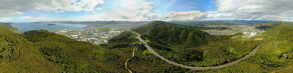
Geography
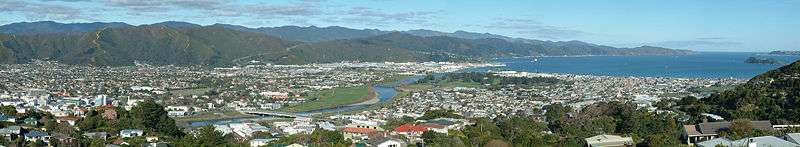
The city centres on the lower (southern) valley of the Hutt River, to the northeast of Wellington. The valley widens as the river nears its mouth, so the central urban area of the city forms a triangle with its longest side along the shoreline. In the upper reaches of the city the Western and Eastern Hutt Hills become closer, culminating in the Taitā Gorge at the northern end of Lower Hutt, separating the city from neighbouring Upper Hutt.
Lower Hutt includes the cluster of small settlements that extend down the eastern coast of Wellington Harbour. These include the two large townships of Wainuiomata (inland) and Eastbourne (on the coast). The city also includes a large area of sparsely-populated land to the east of the harbour, extending to Pencarrow Head and into the Rimutaka Ranges.
Lower Hutt's boundaries include the islands in Wellington Harbour, the largest of which, Matiu/Somes Island, is commonly referred to by its former name of Somes Island.
Climate
Lower Hutt has a humid climate with relatively warm summers and mild winters with the occasional storm.
| Climate data for Lower Hutt | |||||||||||||
|---|---|---|---|---|---|---|---|---|---|---|---|---|---|
| Month | Jan | Feb | Mar | Apr | May | Jun | Jul | Aug | Sep | Oct | Nov | Dec | Year |
| Record high °C (°F) | 28.8 (83.8) |
30.9 (87.6) |
28.6 (83.5) |
26.5 (79.7) |
23.0 (73.4) |
19.6 (67.3) |
18.2 (64.8) |
20.1 (68.2) |
24.3 (75.7) |
23.6 (74.5) |
27.5 (81.5) |
29.6 (85.3) |
30.9 (87.6) |
| Average high °C (°F) | 22.5 (72.5) |
22.6 (72.7) |
20.9 (69.6) |
18.4 (65.1) |
15.9 (60.6) |
13.4 (56.1) |
12.8 (55) |
13.8 (56.8) |
15.7 (60.3) |
16.9 (62.4) |
18.7 (65.7) |
20.7 (69.3) |
17.7 (63.8) |
| Daily mean °C (°F) | 18.2 (64.8) |
18.3 (64.9) |
16.6 (61.9) |
14.1 (57.4) |
12.1 (53.8) |
9.9 (49.8) |
9.0 (48.2) |
9.9 (49.8) |
11.6 (52.9) |
13.0 (55.4) |
14.5 (58.1) |
16.7 (62.1) |
13.7 (56.6) |
| Average low °C (°F) | 14.0 (57.2) |
14.0 (57.2) |
12.2 (54) |
9.8 (49.6) |
8.3 (46.9) |
6.3 (43.3) |
5.2 (41.4) |
6.0 (42.8) |
7.6 (45.7) |
9.1 (48.4) |
10.4 (50.7) |
12.8 (55) |
9.6 (49.3) |
| Record low °C (°F) | 5.2 (41.4) |
5.0 (41) |
4.6 (40.3) |
2.5 (36.5) |
−1.0 (30.2) |
−1.9 (28.6) |
−3.3 (26.1) |
−1.1 (30) |
−2.2 (28) |
0.8 (33.4) |
2.1 (35.8) |
5.0 (41) |
−3.3 (26.1) |
| Average precipitation mm (inches) | 84 (3.31) |
81 (3.19) |
87 (3.43) |
88 (3.46) |
117 (4.61) |
154 (6.06) |
144 (5.67) |
136 (5.35) |
109 (4.29) |
145 (5.71) |
99 (3.9) |
94 (3.7) |
1,338 (52.68) |
| Mean monthly sunshine hours | 235 | 199 | 198 | 159 | 135 | 105 | 124 | 146 | 156 | 176 | 192 | 204 | 2,029 |
| Source: Paradise.net[4] | |||||||||||||
Hutt River
A single major aquifer dominates the lower Hutt Valley: the Hutt River, originally named Heretaunga and as of 2016 known as Awakairangi / Hutt River. Awakairangi in the Maori language means "river of food from the sky".
Lower Hutt occupies the lower regions of the flood plain of the river, one of the most significant features of the city. In the 20th century the Hutt River Board built stopbanks to contain the river,[5] but the threat of flooding from heavy rainfall persists. In 1985 the river burst its banks, and since then floods have been on a smaller scale. Smaller streams and storm-water drains have also caused occasional problems when rainfall exceeds average levels.
Much of the land adjacent to the river is protected as reserve and provides popular recreational areas, with walking and cycling trails and grassed areas at various points along both sides of the river up the Hutt Valley.
With lower river levels in mid-summer, algal blooms have contributed to making slow-flowing areas anoxic. The algal blooms have been attributed as the cause of death of a small number of dogs swimming in the river, as well as of skin reactions in the case of swimmers.
The river is crossed by seven bridges within the city, and has seen many times that number built and replaced since the 1850s.
Tributaries of the Hutt River within Lower Hutt include:
- Waiwhetu Stream
- Opahu Stream (Black Creek)[6]
Suburbs
Here are listed the following suburbs of Lower Hutt City (unofficial suburbs are in italics).[7]
- Northern Ward
- Pomare2; Stokes Valley2; Taitā2
- Western Ward
- Haywards1; Manor Park1; Kelson1; Belmont1; Tirohanga1; Harbour View1; Melling1; Normandale1; Maungaraki1; Alicetown1
- Harbour Ward – Petone Community Board
- Ava1; Korokoro1; Petone1; Waiwhetū2; Moera2; Gracefield2; Seaview2;
- Harbour Ward – Eastbourne Community Board
- Point Howard3; Sorrento Bay3; Lowry Bay3; York Bay3; Mahina Bay3; Sunshine Bay3; Days Bay3; Eastbourne3
- Wainuiomata Ward
- Wainuiomata2; Wainuiomata Coast; Pencarrow Head
Notes:
1 – Suburbs west of the Hutt River
2 – Suburbs east of the Hutt River
3 – Suburbs from the Eastern Harbour
Demographics
| Historical population | ||
|---|---|---|
| Year | Pop. | ±% p.a. |
| 1996 | 98,300 | — |
| 2001 | 98,600 | +0.06% |
| 2006 | 100,700 | +0.42% |
| 2013 | 100,500 | −0.03% |
| Source: [8] | ||
Lower Hutt is home to 104,700 people, of which 104,100 live in the urban area.[1] The city's population has remained stable since the 1990s.[8]
Culture and identity
At the 2013 Census of Population and Dwellings, 71.0 percent of Lower Hutt residents identified as of European ethnicity, 17.1 percent as Māori, 11.7 percent as Asian, 11.0 percent as Pacific Peoples, 1.1 percent as Middle Eastern/Latin American/African, and 1.6 percent as another ethnicity (mainly 'New Zealander').[9]
23.7 percent of Lower Hutt's population was born overseas, compared to 25.2 percent for New Zealand as a whole. Asia is the largest region of origin, accounting for 30.7 percent of the overseas-born population in Lower Hutt.[10][9]
Around 50.4 percent of Lower Hutt residents affiliate with Christianity and 6.7 percent affiliate with non-Christian religions, while 40.6 percent are irreligious. Catholicism is the largest Christian denomination in Lower Hutt with 16.4 percent affiliating, while Anglicanism is the second-largest with 10.8 percent affiliating. Hinduism (3.3 percent) and Buddhism (1.5 percent) are the largest non-Christian religions.[9]
| Ethnicity | Number | % |
|---|---|---|
| European | 66,051 | 71.0 |
| New Zealand European | 61,071 | 65.6 |
| English | 891 | 1.0 |
| Dutch | 693 | 0.7 |
| British | 636 | 0.7 |
| European (not further defined) | 549 | 0.6 |
| Scottish | 474 | 0.5 |
| Māori | 15,876 | 17.1 |
| Asian | 10,893 | 11.7 |
| Indian | 3,678 | 4.0 |
| Chinese | 3,639 | 3.9 |
| Filipino | 1,101 | 1.2 |
| Sri Lankan | 534 | 0.6 |
| Pacific peoples | 10,257 | 11.0 |
| Samoan | 6,675 | 7.2 |
| Cook Islands Maori | 1,494 | 1.6 |
| Tokelauan | 969 | 1.0 |
| Tongan | 942 | 1.0 |
| Middle Eastern/Latin American/African | 1,062 | 1.1 |
| Other | 1,509 | 1.6 |
| New Zealander | 1,461 | 1.6 |
| Total people stated | 93,060 | 100.0 |
| Not elsewhere included | 5,178 | 5.3 |
Economy
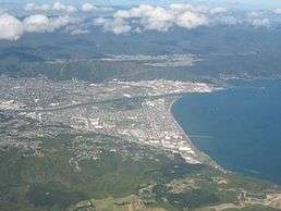
Historically, Petone, Seaview and Gracefield have been the main area for industry in the Wellington region, with industries including meat processing and freezing, motor vehicle assembly, and timber processing. As business have taken advantage of global manufacturing efficiencies, much of this large scale industry has changed to smaller design-led and medium-sized industries exporting to the world. Over the past 25 years service, distribution, and consumer-oriented sectors have increased. Lower Hutt remains the main location for light industrial activity in the Wellington Region.
In 2010 the lower reaches of the Waiwhetu Stream was cleaned up to remove toxins from decades of industry use. The channel was also widened to better protect against floods and native plantings and management has seen native waterlife and birds return to their habitat.[12]
Petone's Jackson Street and neighbouring areas have seen a resurgence in to one of Wellington's most popular retail and hospitality area.
Lower Hutt has one of the greatest proportion of science, technology and high value manufacturing businesses in New Zealand. Cutting edge Crown Research Institutes such as GNS Science and business accelerator Callagahan Innovation Ltd are based in Lower Hutt along with over 800 research organisations in high-end manufacturing, research and technology.[13]
The suburb of Avalon was home to New Zealand's television industry from 1975 until the late 1980s. The Avalon Television Studios were New Zealand's first purpose-built television studios, and is the largest television studio complex in New Zealand and Australasia. The studios were home to Television One from 1975 to 1980, when it merged with South Pacific Television to form Television New Zealand (TVNZ). After 1989 most of TVNZ's operations moved to Auckland, and the studios were eventually sold off in 2012 to a consortium of Wellington investors.[14] Avalon continues to operate independently with seven film and television studios used as primarily as a feature film production base.
A large proportion of Lower Hutt's residents commute to the mainly commercial and Government offices in Wellington City 12 km to the south-west.
The Civil Aviation Authority of New Zealand (CAA) has its headquarters in Aviation House in Petone, Lower Hutt.[15]
Culture and leisure
Several education and research facilities of national significance are in the southern half of the city. Cultural facilities include the Dowse Art Museum and the Avalon film and television studios
The city possesses civic administration buildings constructed in the 1950s that are regarded as representative architecture of the era. A building of national significance is Vogel House, a two-storey wooden residence that was the official residence of the Prime Minister of New Zealand for much of the 20th century. It is a prime example of early colonial architecture in New Zealand and operates today as a tourist attraction.
The city is popular for outdoor sports, especially mountain biking, hiking, recreational walking and fishing. The central city is home to Westfield Queensgate, a large shopping centre. The Riverbank car park adjacent to the central city is home to a Saturday market.[16]
Among the filming locations for The Lord of the Rings (film series) directed by Peter Jackson, Dry Creek quarry, which dominates the hills above the suburb of Taitā, became the site for a huge medieval castle built for scenes of Helm's Deep and Minas Tirith.
Education
Lower Hutt has four state secondary schools: Taita College, Naenae College, Hutt Valley High School (the largest) and Wainuiomata High School. Other secondary schools include Chilton Saint James School, a private girls school; Raphael House Rudolf Steiner School, a state integrated Waldorf education school; Sacred Heart College, a state integrated Catholic girls school; St Bernard's College, a state integrated Catholic boys school; and St Oran's College, a state integrated Presbyterian girls school.
The city is home to two tertiary institutes: the Wellington Institute of Technology in Petone, and The Open Polytechnic of New Zealand in Waterloo.
Media
The city is served by The Dominion Post and community newspapers.
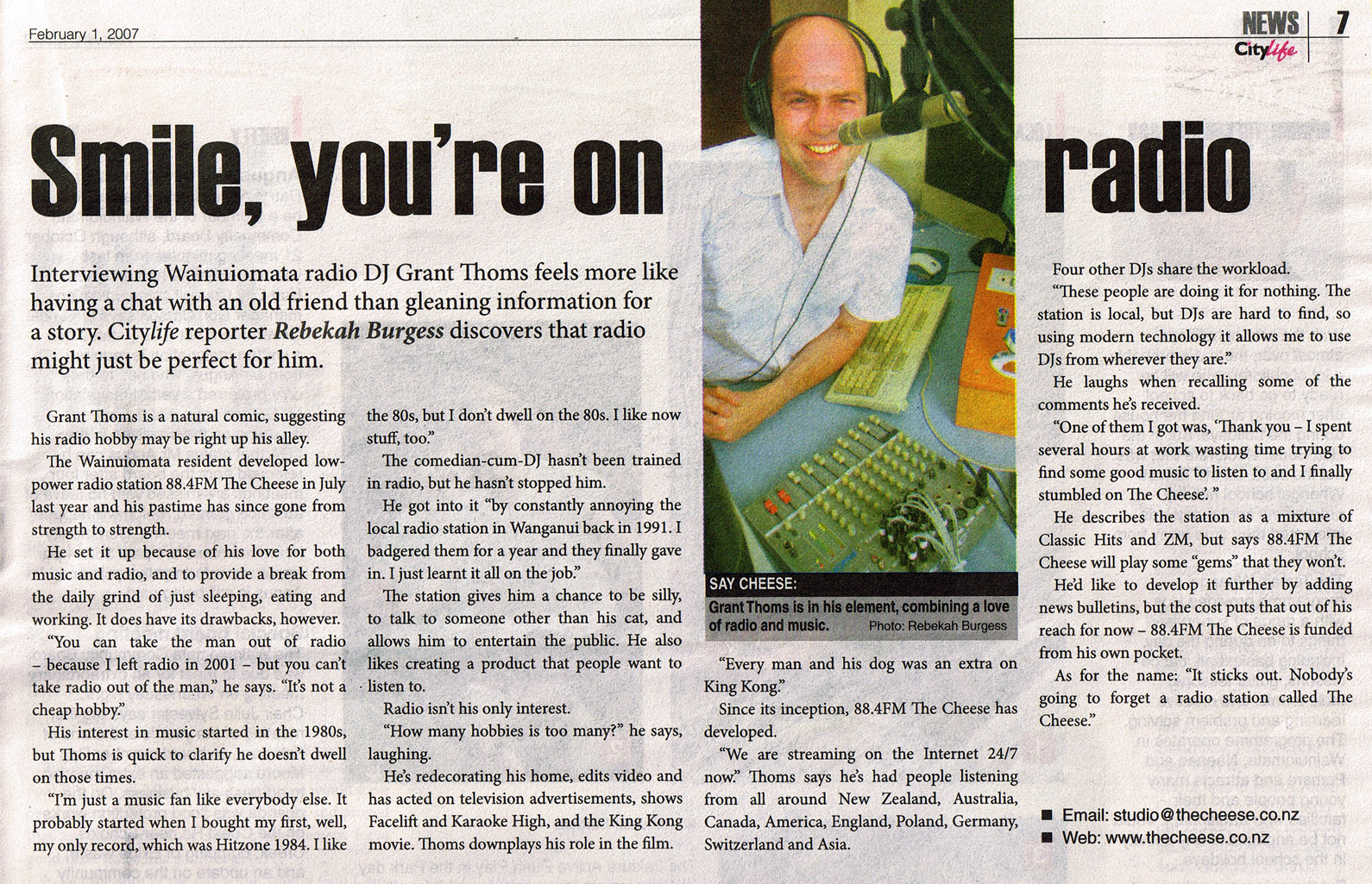
Local LPFM radio station The Cheese broadcasts in the city, and is licensed with APRA and PPNZ in New Zealand for music broadcasting rights. It began Saturday 1 July 2006 and its original frequency was at 88.4 FM from Wainuiomata. The station can be heard in Lower Hutt on 87.9 MHz FM with simulcasting via their official website. Subscribers to Vodafone TV can hear The Cheese on channel 417. The station broadcasts a mix of music from the 80s, 90s, recent and current hits.[17][18]
Flora and fauna
Hills to about 350 m (1000 ft) line both sides of the valley within the city limits. The western hills have been populated as residential areas, but the eastern side is protected and clad in native bush and scrub, and the ubiquitous gorse in areas that have been cleared as a result of scrub fires or earlier human activity.
Native birds are common, including the New Zealand pigeon, tui, grey fantail, silvereye, shining cuckoo (in season), grey warbler and morepork. Introduced species include the common blackbird, song thrush, house sparrow, European goldfinch, common chaffinch, common starling, and Australian magpie.
Notable people
- Terence Burns (born 1938), cricketer
- Brad McKay (doctor) (born 1979), Australian medical doctor, sceptic, television personality and author
- Lloyd Jones (born 1955), author
- Alan MacDiarmid (1927–2007), Nobel laureate
- Anna Paquin (born 1982), Oscar winning actress
- Peter Hogg (born 1939), Canadian lawyer, author and legal scholar best known as the leading authority on Canadian constitutional law
- Nick Willis (born 1983), two-time Olympic medallist (Beijing and Rio)
- Piri Weepu (born 1983), former All Blacks player and current rugby union player
- Tana Umaga (born 1973), former All Blacks captain, former player and current rugby union coach
- Julian Dennison (born 2002), child actor.
Sister-city relationships
Lower Hutt has five sister cities:[19]


Tempe was the first Sister City, in 1981; Minoh City in 1995; Xi'an since 2000; Taizhou formalised the agreement in 2008; and Laredo the most recent, in 2011.
Image gallery


References
- 1 2 3 "Subnational Population Estimates: At 30 June 2017 (provisional)". Statistics New Zealand. 24 October 2017. Retrieved 24 October 2017. For urban areas, "Subnational population estimates (UA, AU), by age and sex, at 30 June 1996, 2001, 2006-16 (2017 boundary)". Statistics New Zealand. 24 October 2017. Retrieved 24 October 2017.
- ↑ Wakefield, Edward Jerningham (1848). The Hand-book for New Zealand: Consisting of the Most Recent Information. John W. Parker. p. 103. Retrieved 5 June 2013.
The main road [...] reaches the west bank of the Hutt at the spot whence [...] the river bends gradually towards the eastern side of the valley. [...] On the same bank of the river, about half a mile lower down, is the village of Aglionby, which contains an excellent Tavern, with good stabling and other accommodation; a small building used as a Church and a school, a blacksmith's forge, and several shops, one or two good farm-houses, and numerous labourers' cottages.
- ↑ http://www.heritage.org.nz/places/places-to-visit/wellington-region/pencarrow-lighthouse
- ↑ "Climate Statistics for Lower Hutt, NZ (1985–2010)". Retrieved 27 January 2012.
- ↑ Easther, John (1991). The Hutt River = Te-Awa-kai-rangi : a modern history, 1840–1990. Wellington Regional Council. Wellington: Wellington Regional Council. ISBN 0909016097. OCLC 34915088.
- ↑
"Opahu Stream – Hutt City". Wellington Water. Retrieved 3 June 2016.
The Opahu Stream (commonly known as Black Creek) begins near Boulcott Street, meanders through the central city and flows into the Hutt River at Whites Line West.
- ↑ "Hutt City Wards and Suburbs" (PDF). Hutt City Council. Archived from the original (PDF) on 9 February 2013. Retrieved 25 August 2013.
- 1 2 "Infoshare; Group: Population Estimates – DPE; Table: Estimated Resident Population for Urban Areas, at 30 June (1996+) (Annual-Jun)". Statistics New Zealand. Retrieved 25 January 2016.
- 1 2 3 "2013 Census QuickStats about culture and identity – data tables". Statistics New Zealand. 15 April 2014. Archived from the original on 24 May 2014. Retrieved 25 January 2016. Note some percentages (e.g. ethnicity, language) may add to more than 100 percent as people could give multiple responses.
- ↑ "Birthplace (detailed), for the census usually resident population count, 2001, 2006, and 2013 (RC, TA) – NZ.Stat". Statistics New Zealand. Retrieved 1 February 2016.
- ↑ "Ethnic group (total responses), for the census usually resident population count, 2001, 2006, and 2013 Censuses (RC, TA, AU)". Statistics New Zealand.
- ↑ http://www.gw.govt.nz/public-excitement-over-waiwhetu-stream-clean-up/
- ↑ "Archived copy". Archived from the original on 3 August 2012. Retrieved 27 March 2012.
- ↑ Tom Hunt and Paul Easton (11 April 2011). "The rise and fall of Avalon". The Dominion Post. Retrieved 1 July 2013.
- ↑ "Contacting the CAA Archived 4 June 2010 at the Wayback Machine.." Civil Aviation Authority of New Zealand. Retrieved on 28 September 2010.
- ↑ Saturday Riverbank Market
- ↑ The Cheese
- ↑ City Life Magazine 1 February 2007. Image of article
- ↑ Lower Hutt Sister Cities on Hutt City Council website Archived 13 August 2014 at the Wayback Machine.
Bibliography
- Carey, Alison (2008). Valleys & Bays – Origins of Street Names in Lower Hutt, including Eastbourne, Petone and Wainuiomata (Paperback)
|format=requires|url=(help). Lower Hutt: Lower Hutt Historical Society. ISBN 978-0-473-13604-8.
External links
| Wikivoyage has a travel guide for Lower Hutt. |
| Wikimedia Commons has media related to Lower Hutt. |
- Hutt City Council
- Hutt Valley tourism website
- Lower Hutt City (Name of City Council) Act 1991
- Maungaraki website
- HuttCam website
- Avalon Film and Television Studios
- New Zealand Racing Board
- GNS Science
- Callaghan Innovation Ltd
Coordinates: 41°13′S 174°55′E / 41.217°S 174.917°E
| Authority control |
|---|