Rangitikei District
| Rangitikei District | |
|---|---|
| Territorial authority | |
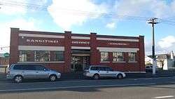 Rangitikei District Council offices in Marton | |
 | |
| Country | New Zealand |
| Region | Manawatu-Whanganui |
| District | Rangitikei District |
| Wards |
Bulls Hunterville Marton Taihape Turakina |
| Formed | 1989 |
| Seat | Marton |
| Government | |
| • Mayor | Andy Watson[1] |
| • Deputy Mayor | Nigel Belsham |
| Area | |
| • Total | 4,479.42 km2 (1,729.51 sq mi) |
| Population (June 2017)[2] | |
| • Total | 15,000 |
| • Density | 3.3/km2 (8.7/sq mi) |
| Time zone | UTC+12 (NZST) |
| • Summer (DST) | UTC+13 (NZDT) |
| Postcode(s) | Map of postcodes |
| Website | Rangitikei District |
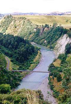
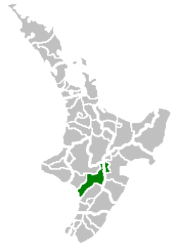
The Rangitikei District is a territorial authority located primarily in the Manawatu-Whanganui Region in the North Island of New Zealand, although a small part, the town of Ngamatea (13.63% by land area), lies in the Hawke's Bay Region. It is located in the southwest of the island, and follows the catchment area of the Rangitikei River.
The Rangitikei District Council is the local government authority for this district. It is composed of a mayor, currently Andy Watson, and 11 councillors, one of whom is the deputy mayor.
History
The Rangitikei District was established in 1989 as part of the 1989 local government reforms.[3]
Education
- Secondary schools
- Rangitikei College, Marton
- Nga Tawa Diocesan School, Marton
- Turakina Maori Girls' College, Marton (until 2015, now closed)[4][5]
- Taihape Area School, Taihape (years 1–13)
Government and politics
Local government
The current Mayor of Rangitikei is Andy Watson, elected in 2013 and re-elected in 2016.[6] Watson was first elected in 2013 by obtaining 1,983 votes (41.5%) of the vote and a majority of 486 (10.2%) beating incumbent mayor Chalky Leary.[7]
Rangitikei District Council is served by eleven councillors elected across five wards. Two councillors are elected from the Bulls ward, one from the Hunterville ward, four from the Marton ward, three from the Taihape ward and one from the Turakina board.[8] The mayor and councillors are due for re-election in October 2016.[9]
District Council, 2016–19 term:
| Mayor | Andy Watson | |
| Councillors | ||
| Bulls ward | Jane Dunn Graeme Platt | |
| Hunterville ward | Dean McManaway | |
| Marton ward | Cath Ash Nigel Belsham Lynne Sheridan David Wilson | |
| Taihape ward | Richard Aslett Angus Gordon Ruth Rainey | |
| Turakina ward | Soraya Peke-Mason | |
Regional government
Rangitikei District is one of ten districts located partially or entirely within the Manawatu-Wanganui region. As such it is represented on the Manawatu-Wanganui Regional Council, known as Horizons Regional Council. Two of the twelve regional councillors are elected by the district in the Manawatu - Rangitikei ward; the two regional councillors elected in the 2016 elections are Bruce Gordon and Gordon McKellar.[10]
National government
Rangitikei is located in the general electorate of Rangitīkei and in the Māori electorate of Te Tai Hauāuru.[11] Rangitīkei is a safe National Party seat since the 1938 election with the exception of 1978–1984 when it was held by Bruce Beetham of the Social Credit Party. Since 2011 it is held by Ian McKelvie.[12]
Te Tai Hauāuru is a more volatile seat, having been held by three different parties since 1996, i.e. New Zealand First, the Māori Party and the Labour Party.[13] Since 2014 it is held by Adrian Rurawhe of the Labour Party.[14]
Geography
Located north of Wellington, the district stretches from the South Taranaki Bight toward the North Island Volcanic Plateau, forming a trapezium-shaped block that includes the towns of Taihape, Bulls, Marton, Hunterville, and Mangaweka. The district has an area of 4,538 km².
Climate
Rangitikei's climate is temperate and has few extremes compared to many parts of New Zealand. According to the Köppen climate classification, this climate is classified as oceanic climate (Cfb). Summers are warm with average temperatures in the low 20s. The most settled weather occurs in summer and early autumn. Winters are mild near the coast and on the plains; it is colder inland and in the hill country, but often frosty, clear and calm. Snowfall occasionally settles in areas 400 m above sea level, such as Taihape. Annual rainfall is moderate and annual hours of bright sunshine can average over 2,000.[15]
| Climate data for Marton | |||||||||||||
|---|---|---|---|---|---|---|---|---|---|---|---|---|---|
| Month | Jan | Feb | Mar | Apr | May | Jun | Jul | Aug | Sep | Oct | Nov | Dec | Year |
| Average high °C (°F) | 22.1 (71.8) |
22.5 (72.5) |
20.7 (69.3) |
18.1 (64.6) |
15.1 (59.2) |
12.8 (55) |
12.1 (53.8) |
12.9 (55.2) |
14.5 (58.1) |
16.4 (61.5) |
18.3 (64.9) |
20.3 (68.5) |
17.2 (63) |
| Daily mean °C (°F) | 17.4 (63.3) |
17.7 (63.9) |
16.1 (61) |
13.7 (56.7) |
11.0 (51.8) |
8.9 (48) |
8.2 (46.8) |
8.9 (48) |
10.5 (50.9) |
12.3 (54.1) |
14.0 (57.2) |
15.9 (60.6) |
12.9 (55.2) |
| Average low °C (°F) | 12.8 (55) |
12.9 (55.2) |
11.6 (52.9) |
9.3 (48.7) |
7.0 (44.6) |
5.1 (41.2) |
4.3 (39.7) |
4.9 (40.8) |
6.6 (43.9) |
8.2 (46.8) |
9.8 (49.6) |
11.6 (52.9) |
8.7 (47.7) |
| Average rainfall mm (inches) | 79.7 (3.138) |
65.2 (2.567) |
80.4 (3.165) |
73.0 (2.874) |
92.3 (3.634) |
98.9 (3.894) |
97.2 (3.827) |
85.1 (3.35) |
80.9 (3.185) |
93.2 (3.669) |
79.0 (3.11) |
92.0 (3.622) |
1,016.9 (40.035) |
| Source #1: Climate-charts.com[16] | |||||||||||||
| Source #2: Climate-data.org[17] | |||||||||||||
| Climate data for Taihape | |||||||||||||
|---|---|---|---|---|---|---|---|---|---|---|---|---|---|
| Month | Jan | Feb | Mar | Apr | May | Jun | Jul | Aug | Sep | Oct | Nov | Dec | Year |
| Average high °C (°F) | 21.6 (70.9) |
21.8 (71.2) |
19.8 (67.6) |
16.9 (62.4) |
13.7 (56.7) |
11.2 (52.2) |
10.5 (50.9) |
11.4 (52.5) |
13.3 (55.9) |
15.5 (59.9) |
17.6 (63.7) |
19.8 (67.6) |
16.1 (61) |
| Daily mean °C (°F) | 16.4 (61.5) |
16.6 (61.9) |
14.9 (58.8) |
12.2 (54) |
9.4 (48.9) |
7.2 (45) |
6.4 (43.5) |
7.3 (45.1) |
9.1 (48.4) |
11.0 (51.8) |
12.8 (55) |
14.9 (58.8) |
11.5 (52.7) |
| Average low °C (°F) | 11.3 (52.3) |
11.4 (52.5) |
10.1 (50.2) |
7.6 (45.7) |
5.2 (41.4) |
3.3 (37.9) |
2.4 (36.3) |
3.2 (37.8) |
4.9 (40.8) |
6.6 (43.9) |
8.1 (46.6) |
10.0 (50) |
7.0 (44.6) |
| Average rainfall mm (inches) | 78 (3.07) |
59 (2.32) |
77 (3.03) |
64 (2.52) |
88 (3.46) |
88 (3.46) |
90 (3.54) |
78 (3.07) |
80 (3.15) |
79 (3.11) |
72 (2.83) |
100 (3.94) |
953 (37.52) |
| Source: Climate-data.org[18] | |||||||||||||
Demographics
2013 census
| Historical population | ||
|---|---|---|
| Year | Pop. | ±% p.a. |
| 1986 | 17,694 | — |
| 1991 | 16,676 | −1.18% |
| 1996 | 16,531 | −0.17% |
| 2001 | 15,102 | −1.79% |
| 2006 | 14,712 | −0.52% |
| 2013 | 14,019 | −0.69% |
| Source: [19][20] | ||
| Towns and meshblocks in Rangitikei[19] | |||
|---|---|---|---|
or meshblock | Pop. | % Total | |
| 1 | Marton | 4,548 | 32.4% |
| 2 | Lake Alice | 2,724 | 19.4% |
| 3 | Pohonui-Porewa | 2,031 | 14.5% |
| 4 | Bulls | 1,515 | 10.8% |
| 5 | Taihape | 1,509 | 10.8% |
| 6 | Moawhango | 651 | 4.6% |
| 7 | Hunterville | 429 | 3.1% |
| 8 | Ratana | 327 | 2.3% |
| 9 | Mangaweka | 150 | 1.1% |
| 10 | Koitiata | 108 | 0.8% |
| 11 | Ngamatea | 27 | 0.2% |
Rangitikei District had a population of 14,019 according to the 2013 New Zealand census. This is a decrease of 693, or 4.7 percent, since the 2006 census. There were 5,733 occupied dwellings, 912 unoccupied dwellings, and 18 dwellings under construction.[19] The district's population at the June 2017 census was 15,000.[2]
Of the residential population, 6,951 (49.6%) were male compared to 48.7% nationally, and 7,068 (50.4%) were female, compared to 51.3% nationally. The district had a median age of 41.8 years, 3.8 years above the national median age of 38.0 years. People aged 65 and over made up 17.6% of the population, compared to 14.3% nationally, and people under 15 years made up 21.1%, compared to 20.4% nationally.[19]
Rangitikei's ethnicity is made up of (national figures in brackets): 80.6% European (74.0%), 24.3% Māori (14.9%), 1.6% Asian (11.8%), 3.9% Pacific Islanders (7.4%), 0.1% Middle Eastern, Latin American or African (1.2%), and 2.4% Other (1.7%).[19]
The district had an unemployment rate of 6.1% of people 15 years and over, compared to 7.4% nationally. The median annual income of all people 15 years and over was $25,700, compared to $28,500 nationally. Of those, 39.9% earned under $20,000, compared to 38.2% nationally, while 19.7% earned over $50,000, compared to 26.7% nationally.[19]
Subdivisions
The district is further subdivided into seven towns and four meshblocks. The meshblocks encompass the surrounding rural areas that are not towns and as such are larger in geographic size. Rangitikei's towns are: Bulls, Hunterville, Koitiata, Mangaweka, Marton, Ratana Community and Taihape; and its meshblocks are: Lake Alice, Moawhango, Ngamatea and Pohonui-Porewa.[21]
As meshblocks—despite their larger size—are the smallest administrative units recorded by Statistics New Zealand, there are small townships of which the demographic statistics are not recorded; all of which are in these meshblocks. These include: Crofton, Mangamahu, Mataroa, Ohingaiti, Pukeokahu, Santoft, Turakina, Utiku and Whangaehu.
Transport
Roads
State Highway 1 ![]()
State Highway 3 ![]()
State Highway 54 ![]()
Public transport
InterCity runs five daily and three non-daily bus services in Marton and Bulls. These include Wanganui–Wellington, Palmerston North–Auckland, Tauranga–Wellington, Wellington–New Plymouth and Auckland–Palmerston North.[22]
Marton used to be serviced by the North Island Main Trunk (or Overlander), a railway line connecting Auckland and Wellington. However, in 2012 the Overlander was replaced by the Northern Explorer, which has fewer stops and does not stop in Marton.
The nearest airports to the district are Whanganui Airport, located 37 km west (of Marton), and Palmerston North Airport, located 44 km southeast. Both airports are domestic only.
See also
References
- ↑ Zaryd Wilson (2013-10-12). "Former Rangitikei mayor 'riding into sunset'". Stuff.co.nz. Retrieved 2015-07-10.
- 1 2 "Subnational Population Estimates: At 30 June 2017 (provisional)". Statistics New Zealand. 24 October 2017. Retrieved 24 October 2017. For urban areas, "Subnational population estimates (UA, AU), by age and sex, at 30 June 1996, 2001, 2006-16 (2017 boundary)". Statistics New Zealand. 24 October 2017. Retrieved 24 October 2017.
- ↑ Derby, Mark (13 July 2012). "Local and regional government - Reforming local government". Te Ara: The Encyclopedia of New Zealand. Retrieved 19 July 2016.
- ↑ Wilkie, Kelsey (26 November 2015). "Turakina Maori Girls' College closed due to multiple failures, minister says". Stuff.co.nz. Retrieved 1 February 2016.
- ↑ Wilkie, Kelsey (25 November 2015). "Turakina Maori Girls' College 'devastated' over school closure". Stuff.co.nz. Retrieved 1 February 2016.
- ↑ Wallis, Anna (14 October 2013). "Watson wins Rangitikei chain". Wanganui Chronicle – nzherald.co.nz. Retrieved 1 February 2016.
- ↑ "Rangitikei District Council – 2013 Triennial Elections" (PDF). Electionz.com. Retrieved 19 May 2016.
- ↑ "Councillors". Rangitikei District Council. Retrieved 1 February 2016.
- ↑ "Local Electoral Act 2001". Parliamentary Counsel Office. Retrieved 18 September 2013.
- ↑ "Council". Horizons Regional Council. Retrieved 1 February 2016.
- ↑ "Find my Electorate". Electoral Commission. Retrieved 1 February 2016.
- ↑ "Rangitīkei Electorate Profile". New Zealand Parliament. 30 September 2012. Retrieved 1 February 2016.
- ↑ "Te Tai Hauāuru Electorate Profile". New Zealand Parliament. 30 September 2012. Retrieved 1 February 2016.
- ↑ "Rurawhe, Adrian". New Zealand Parliament. 4 December 2015. Retrieved 1 February 2016.
- ↑ "Weather & Climate". Rangitikei District Council. Retrieved 23 July 2016.
- ↑ "Marton Ross St., New Zealand". Climate-charts.com. Retrieved 23 July 2016.
- ↑ "Climate: Marton". Climate-data.org. Retrieved 23 July 2016.
- ↑ "Climate: Taihape". Climate-data.org. Retrieved 26 July 2016.
- 1 2 3 4 5 6 "2013 Census tables about a place: Rangitikei District". Statistics New Zealand. Retrieved 1 February 2016.
- ↑ "1996 Census of Population and Dwellings – Census Night Population". Statistics New Zealand. 28 February 1997. Archived from the original on 13 February 2016. Retrieved 1 February 2016.
- ↑ "2013 Census map – QuickStats about a place". Statistics New Zealand. Retrieved 2 February 2016.
- ↑ "Marton – Bus Timetable". InterCity. 1 February 2016. Retrieved 1 February 2016.
External links
- Rangitikei District Council
- Rangitikei.com
- Recreation
- Some information about the history of the Rangitikei District at www.movetothecountry.co.nz
The Rangitikei District, Manawatu-Wanganui, New Zealand | |||||||||
|---|---|---|---|---|---|---|---|---|---|
| Main towns and meshblocks | |||||||||
| Minor towns and localities | |||||||||
| Schools |
| ||||||||
| Electorates |
| ||||||||
| Members of Parliament |
| ||||||||
| Mayor (Council) |
| ||||||||
| Bodies of water | |||||||||
| Transportation | |||||||||
| Other | |||||||||