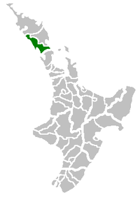
Kaipara District
| Kaipara District | |
|---|---|
| Territorial authority | |
 Kaipara District Council building in Dargaville | |
 | |
| Country | New Zealand |
| Region | Northland |
| District | Kaipara District Council |
| Wards |
Dargaville Otamatea Central West Coast |
| Seat | Dargaville |
| Government | |
| • Mayor | Jason Smith elected 2018 |
| • Deputy Mayor | Peter Wethey |
| Area | |
| • Total | 3,117.09 km2 (1,203.52 sq mi) |
| Population (22,500 (June 2017))[1] | |
| • Total | 22,500 |
| • Density | 7.2/km2 (19/sq mi) |
| Time zone | UTC+12 (NZST) |
| • Summer (DST) | UTC+13 (NZDT) |
| Postcode(s) | Map of postcodes |
| Website | Kaipara District Council |
The Kaipara District is located in the Northland Region in northern New Zealand.
Geography

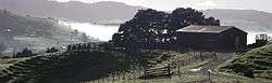
Kaipara District is located in the rolling hills around the northern shores of the Kaipara Harbour, a large natural harbour open to the Tasman Sea. Kaipara District Council shares management of the harbour with various other organisations, most notably Northland Regional Council (in the north) and Auckland Council to the south.[2]
The roughly triangular district stretches from a thinning of the Northland Peninsula south of Kaiwaka and Mangawhai in the southeast to the Waipoua Forest in the northwest. The District's western boundary is defined by Ripiro Beach which stretches down Northland’s west coast from Maunganui Bluff and the Waipoua Forest in the North, to Pouto at the entrance to the Kaipara Harbour. The region is bisected by the Northern Wairoa River and its tributaries, which flow into the northern end of the Kaipara Harbour.
Population
The District has no major urban centre but does have numerous towns and villages including Dargaville (the primary service centre in the west), Ruawai, Matakohe, Paparoa, Maungaturoto, Kaiwaka, Mangawhai, Tinopai, Te Kopuru, Kaihu, Pahi and Whakapirau as well as the rural area which surrounds them. It has a population of 22,500 (June 2017),[1] of whom about 4450 live in Dargaville, the seat of the district council.
The population is largely rural, living in small settlements scattered amongst the rolling hills or nestled on the shores of the harbour, including the harbour villages of Tinopai, Pahi and Whakapirau. The area around Dargaville is noted for the high proportion of residents of Dalmatian descent and has an active Dalmatian Club.
The nearest city is Whangarei, 45 kilometres northeast of Dargaville.
Community spirit is strong among the various rural communities, as is evident by the numerous local clubs, volunteer organisations and other initiatives. Dargaville has an annual Arts and Crafts Festival run by the local Rotary club and also features weekly Riverside Produce Markets on Thursday afternoons. Maungaturoto has a monthly market on a Friday from 4pm to 7pm at the Maungaturoto Hall and also has a volunteer group (Maungaturoto Residents Association)[3] dedicated to beautifying the town. A similar volunteer group also exists in Ruawai and Paparoa (Progressive Paparoa).
Local government
Kaipara District is divided into four wards:
- Central
- Dargaville
- Otamatea
- West Coast
On 6 September 2012, commissioners were appointed by the Minister of Local Government to take over the governance of the Kaipara District Council. The appointment followed the completion of the work of the review team which had been put in place by the Minister of Local Government in June 2012 to assess the financial management and governance challenges facing the council. The review team concluded that the challenges were beyond the ability of the mayor and councillors to manage. The elected council agreed and asked the Minister to appoint commissioners. The Kaipara District Council commissioners are John Robertson (chairman), Richard Booth, Colin Dale and Peter Winder.
See also
References
- 1 2 "Subnational Population Estimates: At 30 June 2017 (provisional)". Statistics New Zealand. 24 October 2017. Retrieved 24 October 2017. For urban areas, "Subnational population estimates (UA, AU), by age and sex, at 30 June 1996, 2001, 2006-16 (2017 boundary)". Statistics New Zealand. 24 October 2017. Retrieved 24 October 2017.
- ↑ "Kaipara facing 'ecological crisis'". The New Zealand Herald. 24 June 2011. Retrieved 29 June 2011.
- ↑ Northland Inc. "Useful Links Maungaturoto Residents Association". Northland Inc. Northland Inc. Retrieved 30 December 2014.
External links
| Wikimedia Commons has media related to Kaipara District. |