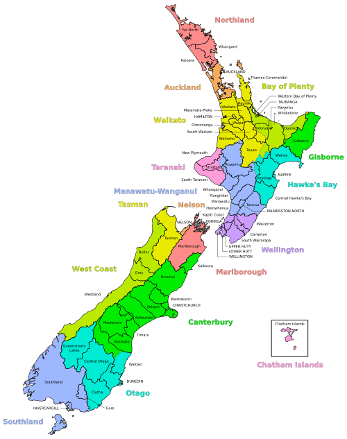
Districts of New Zealand
A district in New Zealand is a territorial authority area governed by a district council as a second-tier of local government in New Zealand, below regional councils. They were formed as a result of local government reforms in 1989. There are 53 districts in New Zealand, and they do not include the 13 city councils (including Auckland Council), and the Chatham Islands Council. District councils serve a combination of rural and urban communities, while city councils administer the larger urban areas. Three districts (Gisborne, Tasman and Marlborough) are unitary authorities also performing the functions of a regional council.
Districts are not subdivisions of regions, and some of them fall within more than one region. Taupo District has the distinction of straddling the boundaries of four different regions. Regional council areas are based on water catchment areas, whereas district council areas are based on community of interest and road access. Regional councils are responsible for the administration of many environmental and public transport matters, while the district councils administer local roads and reserves, sewerage, building consents, the land use and subdivision aspects of resource management, and other local matters. Some activities are delegated to council-controlled organisations.
Districts
There are currently 54 districts:[1]
North Island
Bay of Plenty Region
Hawke's Bay Region
Manawatu-Wanganui Region
Northland Region
Taranaki Region
Waikato Region
Wellington Region
Mixed
- Rangitikei District (Manawatu-Wanganui: 86.37%; Hawke's Bay: 13.63%)
- Rotorua District (Bay of Plenty: 61.52%; Waikato: 38.48%)
- Stratford District (Taranaki: 68.13%; Manawatu-Wanganui: 31.87%)
- Tararua District (Manawatu-Wanganui: 98.42%; Wellington: 1.58%)
- Taupo District (Waikato: 73.74%; Bay of Plenty: 14.31%; Hawke's Bay: 11.26%; Manawatu-Wanganui: 0.69%)
- Waitomo District (Waikato: 94.87%; Manawatu-Wanganui: 5.13%)
Unitary authorities
South Island
Canterbury Region
Otago Region
Southland Region
West Coast Region
Mixed
- Waitaki District (Canterbury: 59.61%; Otago: 40.39%)
Unitary authorities
Notes:
- Kaikoura District was transferred from the Nelson-Marlborough Region to the Canterbury Region in 1992.
- Banks Peninsula District became part of Christchurch as a result of 2005 referendum.
- Franklin District, Papakura District and Rodney District no longer exist as of 2010. They became part of other districts and Auckland Region.
See also
- Territorial authorities of New Zealand
- List of former territorial authorities in New Zealand
- Politics of New Zealand
- Community Board (New Zealand)
References
- ↑ "Districts". Department of Internal Affairs. Retrieved 2 June 2011.