Googong, New South Wales
Googong is a suburb of Queanbeyan and is located within the Queanbeyan–Palerang Regional Council local government area, located to the south of the Queanbeyan CBD.
| Googong Queanbeyan, New South Wales | |||||||||||||||
|---|---|---|---|---|---|---|---|---|---|---|---|---|---|---|---|
 | |||||||||||||||
Googong | |||||||||||||||
| Coordinates | 35°42′S 149°22′E | ||||||||||||||
| Population | 2,690 (2016 census)[1] | ||||||||||||||
| Location | 10 km (6 mi) S of Queanbeyan | ||||||||||||||
| LGA(s) | Queanbeyan–Palerang Regional Council | ||||||||||||||
| County | Murray | ||||||||||||||
| Parish | Googong | ||||||||||||||
| State electorate(s) | Monaro | ||||||||||||||
| Federal Division(s) | Eden-Monaro | ||||||||||||||
| |||||||||||||||
Googong contains the developed areas of Fernleigh Park, Little Burra, Googong Township and Mount Campbell Estate. It borders Jerrabomberra and Karabar on the north and Environa on the west. It is about 10 kilometres (6.2 mi) south of the Queanbeyan central business district.
Googong includes many shops and cafes including Fika, IGA and a club with cafe and swimming pool.
History
Googong is located in the Monaro district of New South Wales. Though considered to be on Ngarigo lands[2], there are five Indigenous groups that have identified a connection to the area.[3] The area also has a long history of European farming and settlement. The township is named after one of the largest farming properties in the area although the meaning and origins of the word Googong remain obscure.
The first part of the original stone homestead was built in 1845 and was first occupied by Alexander McDonald, an employee of the Campbell family who were early settlers of the Canberra region.[4] The homestead was later renamed ‘Beltana’. The area around Googong Township has a number of historic features including the old London Bridge Homestead and the London Bridge Arch, a remarkable natural limestone bridge formed by Burra Creek over thousands of years.[5] The nearby Googong Dam, fed by the Queanbeyan River and numerous creeks, is by far the largest in the ACT region. It was constructed in 1977.[6]
Googong Foreshores is the name given to the area around Googong Dam. This is separate from the town of Googong and is managed as a water catchment, wildlife refuge and public recreation area. Park Care volunteers help to protect the national and cultural values of the Foreshores.
The project
Planning for the Googong site began in the early 2000s, with approval to begin the re-zoning process granted in 2006.[7] The findings of the Independent Queanbeyan Land Release Inquiry, issued by the NSW Minister for Planning in September of that year recommended the site as the future residential growth area for the City of Queanbeyan. In November 2007, the NSW Department of Planning issued a Section 65 certificate enabling the public exhibition of the draft Local Environmental Plan which was available for public comment until February 2008. The re-zoning of the site to allow residential development was approved in December 2009.
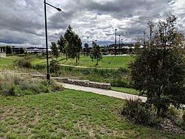
At that time it was announced that Googong will have five neighbourhoods, a town centre and four local shopping centres, as well as 183 hectares of open space to provide recreational, ecological and visual amenity. As part of the project, the developers undertook a Voluntary Planning Agreement to dedicate land and undertake construction works valued at over $300 million. These included road and intersection upgrades on local access roads and the construction of community facilities including a library, community centre, indoor sports and aquatic centre, sporting fields and open spaces and a neighbourhood clubhouses containing an indoor swimming pool, tennis courts, gym and meeting rooms. The Development Control Plan for the township of Googong was approved by Queanbeyan City Council in October 2010. The final plan was formally adopted in June 2013.[8] Civil construction commenced at Googong in 2012 with the first residents moving in in February 2014.
Googong Water Cycle Project
The township has been designed around an integrated water cycle system.[9] This includes a dedicated water recycling plant which has been calculated to reduce potable water consumption by around 60%. It will recycle up to 62% of waste water for non-potable use including gardens, toilet flushing and irrigation of parks and public areas. The environmental assessment report went on public exhibition in November 2010[10] and was approved the following year. The water project was launched by the then Federal member for Eden Monaro, Mike Kelly, in August 2013.[11] It attracted a $5.1 million subsidy from the government’s Water for the Future initiative.
Gallery
 1909 map of the Parish of Googong (blue border).
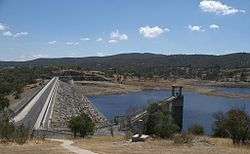 The Googong Dam.
References
- Australian Bureau of Statistics (27 June 2017). "Googong (state suburb)". 2016 Census QuickStats. Retrieved 28 June 2017.

- https://www.goveonline.com.au/aboriginal-languages-in-nsw-to-be-protected-by-legislation-minister-says/
- Environmental Assessment Googong Township Water Cycle Project November 2010 http://compliance.googong.net/upload/pdfs/project-documents/an-Ch12-Heritage.pdf
- Googong Homestead 1845-1976 Archives ACT Research Guide 1978 http://www.archives.act.gov.au/__data/assets/pdf_file/0003/562584/Googong_Homestead_1845-1976.pdf
- ACT Parks and Recreation http://www.tams.act.gov.au/parks-recreation/water_catchments/rural_water_catchments/googong_foreshores
- Actew Corporation website accessed 4 July 2014 "Archived copy". Archived from the original on 21 April 2013. Retrieved 30 January 2010.CS1 maint: archived copy as title (link)
- CIC Australia website, accessed 4 July 2014
- Queanbeyan City Council – Development Control Plans http://www.qcc.nsw.gov.au/Building-and-Planning/Planning-Policies/Development-Control-Plans/DCP
- googong.net http://googong.net/upload/file/news/Googong-township-water-cycle-project.pdf
- NSW Planning and Environment http://majorprojects.planning.nsw.gov.au/index.pl?action=view_job&job_id=3119
- The Canberra Times 1 August 2013 http://www.canberratimes.com.au/act-news/thirst-for-innovation-sets-town-apart-20130731-2qzsd.html
External links
| Wikimedia Commons has media related to Googong, New South Wales. |
| Queanbeyan suburbs |
|
|---|---|
| Localities and rural places |
|
Main Article: Local government areas of New South Wales | |