Breadalbane, New South Wales
Breadalbane /brəˈdɔːlbən/ is a small village located in the Southern Tablelands of New South Wales, Australia in Upper Lachlan Shire.[2] It is located on the Lachlan River headwaters and not far from Goulburn. At the 2016 census, Breadalbane had a population of 100.[1]
| Breadalbane New South Wales | |||||||||||||||
|---|---|---|---|---|---|---|---|---|---|---|---|---|---|---|---|
 | |||||||||||||||
Breadalbane | |||||||||||||||
| Coordinates | 34°47′49″S 149°26′50″E | ||||||||||||||
| Population | 100 (2016 census)[1] | ||||||||||||||
| LGA(s) | Upper Lachlan Shire | ||||||||||||||
| County | Argyle | ||||||||||||||
| Parish | Milbang | ||||||||||||||
| State electorate(s) | Goulburn | ||||||||||||||
| Federal Division(s) | Hume | ||||||||||||||
| |||||||||||||||
Overview
This little town is also located nearby and adjacent to the major Hume Highway which links Sydney to Melbourne via an inland route. Previously the highway used to go through the small town however it was bypassed in the early 1990s. Breadalbane is also situated on the Main Southern Railway, the NSW portion of the Sydney–Melbourne rail line.
Breadalbane is also located nearby to the start of the Federal Highway which branches off the Hume Highway just south of Goulburn and heads directly towards Canberra in the Australian Capital Territory, and the capital city of Australia where the Commonwealth Federal Parliament sits.
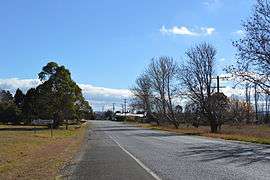
Breadalbane is an historic town and it is located on the Old Hume Highway together with Cullerin and Gunning. There is not much now at Breadalbane aside from a few houses. In the past there was accommodation and a pub, service station and a railway station. However, these services are no longer available, although the former hotel and service station remain standing and are today used as private residences. The railway station opened in 1875 and closed in 1974,[3] although the signal box remained in use until 1979. All trace of the station has been removed, although a loading bank is still standing.
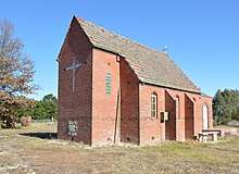
The Chisholm Memorial Church (St Silas' Anglican church) at Breadalbane was founded in 1937 in memory of Caroline Chisholm.
References
- Australian Bureau of Statistics (27 June 2017). "Breadalbane (State Suburb)". 2016 Census QuickStats. Retrieved 7 July 2017.

- "Breadalbane". Geographical Names Register (GNR) of NSW. Geographical Names Board of New South Wales. Retrieved 30 July 2017.
- "Breadalbane railway station". www.nswrail.net. Retrieved 8 April 2008.
External links
![]()
| Towns | |
|---|---|
| Localities and rural places |
|
Main Article: Local government areas of New South Wales | |