Fak Tha District
Fak Tha (Thai: ฟากท่า, pronounced [fâːk tʰâː]) is a district (amphoe) of Uttaradit Province, northern Thailand.
Fak Tha ฟากท่า | |
|---|---|
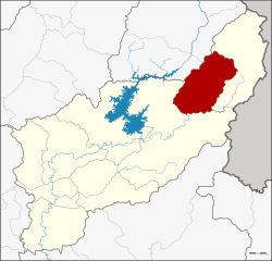 District location in Uttaradit Province | |
| Coordinates: 17°59′32″N 100°52′43″E | |
| Country | Thailand |
| Province | Uttaradit |
| Seat | Fak Tha |
| District established | 1937 |
| Area | |
| • Total | 632.689 km2 (244.283 sq mi) |
| Population (2008) | |
| • Total | 15,128 |
| • Density | 24.2/km2 (63/sq mi) |
| Time zone | UTC+7 (ICT) |
| Postal code | 53160 |
| Geocode | 5305 |
History
The minor district (king amphoe) Fak Tha was established in 1937 as a subordinate of Nam Pat District.[1] On 20 July 1958 it was upgraded to a full district.[2]
Geography
Neighboring districts are (from the east clockwise) Ban Khok and Nam Pat of Uttaradit Province, and Na Muen of Nan Province.
The main river of the district is the Pat River, a tributary of the Nan River.
Administration
The district is divided into four sub-districts (tambon), which are further subdivided into 33 villages (muban). Fak Tha is a sub-district municipality (thesaban tambon) which covers parts of tambon Fak Tha and Long Don. There are a further four tambon administrative organizations (TAO).
| No. | Name | Thai | Villages | Pop.[3] |
|---|---|---|---|---|
| 1. | Fak Tha | ฟากท่า | 11 | 5,190 |
| 2. | Song Khon | สองคอน | 11 | 3,379 |
| 3. | Ban Siao | บ้านเสี้ยว | 6 | 3,392 |
| 4. | Song Hong | สองห้อง | 5 | 3,167 |
Places
Education
- Fak Tha Wittaya School[4]
- Anu Ban Fak Tha School[5]
- Rattanaprasitwit Industrall
Temples
- Wat Ban Doen
- Wat Ban Huai Luek
- Wat Ban Lum
- Wat Fak Na
- Wat Huai Sai
- Wat Huai Sun
- Wat Hua Thung
- Wat Kok Tong
- Wat Na Nam
- Wat Na Rai Diao
- Wat Nong Hua Na
- Wat Pho Chai
- Wat Pho Du
- Wat Pho Tia
- Wat Phon That
- Wat Sam Bon
- Wat Wang Kong
- Wat Wang-o
Hospital
- Fak Tha Hospital
References
- ประกาศกระทรวงมหาดไทย เรื่อง ตั้งกิ่งอำเภอฟากท่า (PDF). Royal Gazette (in Thai). 54 (0 ง): 2099. 1937-11-29.
- พระราชกฤษฎีกาจัดตั้งอำเภอกระสัง อำเภอกระนวน อำเภอบางกอกใหญ่ อำเภอขุนหาร อำเภอพนา อำเภอปากช่อง อำเภอวังเหนือ อำเภอวังชิ้น อำเภอแม่ทา อำเภอหนองหมู อำเภอสระแก้ว อำเภออมก๋อย อำเภอบางซ้าย อำเภอทับสะแก อำเภอบุณฑริก อำเภอลานสะกา อำเภอจอมบึง อำเภอท่ายาง อำเภอสามเงา อำเภอฟากท่า อำเภอบ้านเขว้า อำเภอชานุมาน อำเภอแม่พริก อำเภอท่าสองยาง อำเภอสะเมิง อำเภอหนองแขม อำเภอพระแสง พ.ศ. ๒๕๐๑ (PDF). Royal Gazette (in Thai). 75 (55 ก): 321–327. 1958-07-22.
- "Population statistics 2008". Department of Provincial Administration. Archived from the original on 2009-08-20.
- "ข้อมูลพื้นฐาน โรงเรียนฟากท่าวิทยา". Retrieved 20 July 2017.
- "ข้อมูลพื้นฐาน โรงเรียนอนุบาลฟากท่า(วัดวังขวัญวันครู 2503)". Retrieved 6 December 2017.