Cho-airong District
Cho-airong (Thai: เจาะไอร้อง, pronounced [t͡ɕɔ̀ʔ.ʔāj.rɔ́ːŋ]) is a district (amphoe) of Narathiwat Province, southern Thailand.
Cho-airong เจาะไอร้อง | |
|---|---|
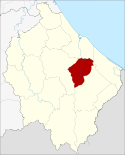 District location in Narathiwat Province | |
| Coordinates: 6°12′6″N 101°50′30″E | |
| Country | Thailand |
| Province | Narathiwat |
| Seat | Chuap |
| Subdistricts | 3 |
| Mubans | 33 |
| District established | 1993 |
| Area | |
| • Total | 162.7232 km2 (62.8278 sq mi) |
| Population (2014) | |
| • Total | 39,236 |
| • Density | 221.2/km2 (573/sq mi) |
| Time zone | UTC+7 (ICT) |
| Postal code | 96130 |
| Geocode | 9613 |
History
Cho-airong was made a minor district (king amphoe) on 31 May 1993, by separating three tambons from Ra-ngae District.[1] On 5 December 1996 it was upgraded to a full district.[2]
Geography
Neighboring districts are (from the north clockwise): Mueang Narathiwat, Tak Bai, Su-ngai Padi and Ra-ngae.
Administration
Central administration
Cho-airong is divided into three sub-districts (tambons), which are further subdivided into 33 administrative villages (mubans).
| No. | Name | Thai | Villages | Pop.[3] |
|---|---|---|---|---|
| 1. | Chuap | จวบ | 8 | 11,726 |
| 2. | Bukit | บูกิต | 14 | 17,955 |
| 3. | Maruebo Ok | มะรือโบออก | 11 | 9,555 |
Local administration
There are three sub-district administrative organizations (SAO) in the district:
- Chuap (Thai: องค์การบริหารส่วนตำบลจวบ) consisting of sub-district Chuap.
- Bukit (Thai: องค์การบริหารส่วนตำบลบูกิต) consisting of sub-district Bukit.
- Maruebo Ok (Thai: องค์การบริหารส่วนตำบลมะรือโบออก) consisting of sub-district Maruebo Ok.
References
- ประกาศกระทรวงมหาดไทย เรื่อง แบ่งเขตท้องที่อำเภอระแงะ จังหวัดนราธิวาส ตั้งเป็นกิ่งอำเภอเจาะไอร้อง (PDF). Royal Gazette (in Thai). 110 (74 ง): 15. June 8, 1993.
- พระราชกฤษฎีกาตั้งอำเภอเหนือคลอง อำเภอนายายอาม อำเภอท่าตะเกียบ อำเภอขุนตาล อำเภอแม่ฟ้าหลวง อำเภอแม่ลาว อำเภอรัษฎา อำเภอพุทธมณฑล อำเภอวังน้ำเขียว อำเภอเจาะไอร้อง อำเภอชำนิ อำเภอโนนดินแดง อำเภอปางมะผ้า อำเภอสนธิ อำเภอหนองม่วง อำเภอเบญจลักษ์ อำเภอโพนนาแก้ว อำเภอบุ่งคล้า อำเภอดอนมดแดง และอำเภอลืออำนาจ พ.ศ. ๒๕๓๙ (PDF). Royal Gazette (in Thai). 113 (62 ก): 5–8. November 20, 1996.
- "Population statistics 2014" (in Thai). Department of Provincial Administration. Retrieved 2015-06-18.
External links
This article is issued from Wikipedia. The text is licensed under Creative Commons - Attribution - Sharealike. Additional terms may apply for the media files.