Si Sakhon District
Si Sakhon (Thai: ศรีสาคร, pronounced [sǐː sǎː.kʰɔ̄ːn]) is a district (amphoe) of Narathiwat Province, southern Thailand.
Si Sakhon ศรีสาคร | |
|---|---|
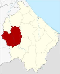 District location in Narathiwat Province | |
| Coordinates: 6°13′53″N 101°30′0″E | |
| Country | Thailand |
| Province | Narathiwat |
| Seat | Sako |
| Area | |
| • Total | 500.1 km2 (193.1 sq mi) |
| Population (2005) | |
| • Total | 31,576 |
| • Density | 63.1/km2 (163/sq mi) |
| Time zone | UTC+7 (ICT) |
| Postal code | 96210 |
| Geocode | 9607 |
History
Originally Tambon Sa Ko was a part of the Rueso District, but the development division of the Thai military settled in the area from 1963–1974, thus developing the infrastructure of Tambon Sa Ko. The interior ministry subsequently created Si Sakhon Minor District (king amphoe) consisting of the two tambons, Sako and Tamayung, on 23 September 1974.[1] It was upgraded to a full district on 25 March 1979.[2][3]
Etymology
The name Si Sakhon refers to the Sai Buri River, which flows through the middle of the district.
Geography
Neighboring districts are (from the north clockwise): Rueso, Ra-ngae, and Chanae of Narathiwat Province; Than To and Bannang Sata of Yala Province.
Administration
The district is divided into six sub-districts (tambons), which are further subdivided into 39 villages (mubans). The township (thesaban tambon) Si Sakhon covers parts of tambons Si Sakhon and Sa Ko. There are a further six tambon administrative organizations (TAO).
| No. | Name | Thai name | Villages | Pop. | |
|---|---|---|---|---|---|
| 1. | Sako | ซากอ | 6 | 6,992 | |
| 2. | Tamayung | ตะมะยูง | 6 | 4,734 | |
| 3. | Si Sakhon | ศรีสาคร | 10 | 8,473 | |
| 4. | Choeng Khiri | เชิงคีรี | 4 | 4,750 | |
| 5. | Kalong | กาหลง | 4 | 2,730 | |
| 6. | Si Banphot | ศรีบรรพต | 9 | 3,897 |
References
- ประกาศกระทรวงมหาดไทย เรื่อง แบ่งท้องที่อำเภอรือเสาะ จังหวัดนราธิวาส ตั้งเป็นกิ่งอำเภอศรีสาคร (PDF). Royal Gazette (in Thai). 91 (158 ง): 3589. September 24, 1974.
- พระราชกฤษฎีกาตั้งอำเภอหนองกุงศรี อำเภอไทรงาม อำเภอบ้านฝาง อำเภออุบลรัตน์ อำเภอเวียงชัย อำเภอดอยเต่า อำเภอนิคมคำสร้อย อำเภอนาหว้า อำเภอเสิงสาง อำเภอศรีสาคร อำเภอบึงสามพัน อำเภอนาดูน อำเภอค้อวัง อำเภอโพธิ์ชัย อำเภอเมืองสรวง อำเภอปลวกแดง อำเภอยางชุมน้อย อำเภอกาบเชิง อำเภอสุวรรณคูหา และอำเภอกุดข้าวปุ้น พ.ศ. ๒๕๒๒ (PDF). Royal Gazette (in Thai). 96 (42 ก Special): 19–24. March 25, 1979.
- narathiwat.go.th