Jimenez, Misamis Occidental
Jimenez, officially the Municipality of Jimenez, is a 3rd class municipality in the province of Misamis Occidental, Philippines. According to the 2015 census, it has a population of 27,654 people.[3]
Jimenez | |
|---|---|
| Municipality of Jimenez | |
 Seal | |
 Map of Misamis Occidental with Jimenez highlighted | |

| |
.svg.png) Jimenez Location within the Philippines | |
| Coordinates: 8°20′00″N 123°50′00″E | |
| Country | |
| Region | Northern Mindanao (Region X) |
| Province | Misamis Occidental |
| District | 1st District |
| Founded | April 7, 1900 |
| Barangays | 24 (see Barangays) |
| Government | |
| • Type | Sangguniang Bayan |
| • Mayor | Rosario K. Balais |
| • Vice Mayor | Joselito C. Chiong |
| • Congressman | Diego C. Ty |
| • Electorate | 20,027 voters (2019) |
| Area | |
| • Total | 81.43 km2 (31.44 sq mi) |
| Elevation | 24.1 m (79.1 ft) |
| Population (2015 census)[3] | |
| • Total | 27,654 |
| • Density | 340/km2 (880/sq mi) |
| • Households | 6,307 |
| Economy | |
| • Income class | 3rd municipal income class |
| • Poverty incidence | 23.63% (2015)[4] |
| • Revenue (₱) | 91,501,097.10 (2016) |
| Time zone | UTC+8 (PST) |
| ZIP code | 7204 |
| PSGC | |
| IDD : area code | +63 (0)88 |
| Climate type | tropical climate |
| Native languages | Subanon language Cebuano Tagalog |
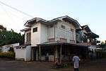
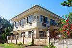
Within the predominantly Catholic town lies the Church of Saint John the Baptist which is one of the oldest monuments in the Philippines. Many Jimeneznons live outside the country but have retained close ties to the town, with "balikbayans" offering community service and philanthropy, and others taking up residence upon retirement abroad.
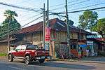
The heritage town is one of the best preserved colonial towns in the entire Philippines. The conservation, preservation, and restoration of the town's heritage structures such as the church and ancestral houses are the main focus of the local government. The town is being pushed to be included in the UNESCO World Heritage List.
Barangays
Jimenez is politically subdivided into 24 barangays.
Climate
| Climate data for Jimenez, Misamis Occidental | |||||||||||||
|---|---|---|---|---|---|---|---|---|---|---|---|---|---|
| Month | Jan | Feb | Mar | Apr | May | Jun | Jul | Aug | Sep | Oct | Nov | Dec | Year |
| Average high °C (°F) | 27 (81) |
28 (82) |
29 (84) |
31 (88) |
31 (88) |
30 (86) |
30 (86) |
30 (86) |
30 (86) |
30 (86) |
29 (84) |
28 (82) |
29 (85) |
| Average low °C (°F) | 23 (73) |
23 (73) |
23 (73) |
23 (73) |
24 (75) |
24 (75) |
23 (73) |
23 (73) |
24 (75) |
24 (75) |
23 (73) |
23 (73) |
23 (74) |
| Average precipitation mm (inches) | 69 (2.7) |
44 (1.7) |
37 (1.5) |
29 (1.1) |
87 (3.4) |
137 (5.4) |
131 (5.2) |
141 (5.6) |
143 (5.6) |
134 (5.3) |
68 (2.7) |
53 (2.1) |
1,073 (42.3) |
| Average rainy days | 9.9 | 7.6 | 7.4 | 8.1 | 21.6 | 26.5 | 26.4 | 26.6 | 25.8 | 24.3 | 15.1 | 10.4 | 209.7 |
| Source: Meteoblue [5] | |||||||||||||
Demographics
| Population census of Jimenez | |||||||||||||||||||||||||||||||||||||||||||||||||
|---|---|---|---|---|---|---|---|---|---|---|---|---|---|---|---|---|---|---|---|---|---|---|---|---|---|---|---|---|---|---|---|---|---|---|---|---|---|---|---|---|---|---|---|---|---|---|---|---|---|
|
| ||||||||||||||||||||||||||||||||||||||||||||||||
| Source: Philippine Statistics Authority[3][6][7][8] | |||||||||||||||||||||||||||||||||||||||||||||||||
In the 2015 census, the population of Jimenez was 27,654 people,[3] with a density of 340 inhabitants per square kilometre or 880 inhabitants per square mile.
Education
Jimenez has three major high schools including School of Saint John the Baptist, Jimenez Bethel Institute, and a public high school located in barangay Corrales.
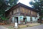
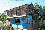
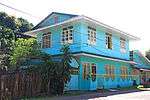
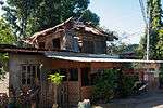
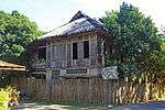
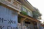
List of presumed Cultural Properties of the Philippines in Jimenez
The following table lists down built heritage structures as identified by the local government of Jimenez:
| Cultural Property wmph identifier |
Site name | Description | Province | City/Municipality | Address/Location | Coordinates | Image |
|---|---|---|---|---|---|---|---|
| Apolinar Jungao Razo House | Misamis Occidental | Jimenez | 8.333659°N 123.844418°E |  | |||
| Bacarro Printing Press | Misamis Occidental | Jimenez | 8.334951°N 123.841198°E |  | |||
| Balbino and Escobia Angus House | Misamis Occidental | Jimenez | 8.333798°N 123.841446°E |  | |||
| Benito Lim and Marcelina Cabalog House | Misamis Occidental | Jimenez | Calderon cor. Sen. Ozamiz Sts. | 8.335584°N 123.839667°E |  | ||
| Casa de Ozamiz | Misamis Occidental | Jimenez | 8.334125°N 123.842983°E |  | |||
| Cayetano Yu and Usebia Larilin House | Misamis Occidental | Jimenez | 8.334243°N 123.841746°E |  | |||
| Celso Velez Valmores, Sr. and Cesaria Docor Documento House | Misamis Occidental | Jimenez | 8.332746°N 123.839452°E |  | |||
| Convent of the Maryknoll Sisters of Mercy | Misamis Occidental | Jimenez | 8.33542°N 123.838873°E |  | |||
| Daniel Lee House | Misamis Occidental | Jimenez | 8.333894°N 123.842698°E |  | |||
| Elang Azcuna House | Misamis Occidental | Jimenez | 8.334027°N 123.841672°E |  | |||
| Francisco Azcuna House | Misamis Occidental | Jimenez | 8.333663°N 123.84434°E |  | |||
| Fructuoso Malon Maulas and Nieves Parmisana House | Misamis Occidental | Jimenez | Burgos St. | 8.333589°N 123.840542°E |  | ||
| Gabriel Haganus and Seferina Eroy House | Misamis Occidental | Jimenez | Burgos St., Barangay Nacional | 8.333946°N 123.838327°E |  | ||
| Gregorio Tak-an and Teodora Olarte House | Misamis Occidental | Jimenez | Calderon cor. Sen. Ozamiz Sts., Barangay Nacional | 8.335781°N 123.839729°E |  | ||
| Guillermo Te House | Misamis Occidental | Jimenez | 8.333704°N 123.844188°E |  | |||
| Honorato Apao and Irene Paredes House | Misamis Occidental | Jimenez | J. Duenas cor Mabini Sts. | 8.33332°N 123.839327°E |  | ||
| Inocencio and Adriana Madrangca House | Misamis Occidental | Jimenez | Burgos St. | 8.33381°N 123.839103°E |  | ||
| Intsik Tia House | Misamis Occidental | Jimenez | 8.334048°N 123.841489°E |  | |||
| Isaac and Severina Quilo | Misamis Occidental | Jimenez | Burgos St. | 8.333531°N 123.840794°E |  | ||
| Isabelo and Teodora Gimeno House | Misamis Occidental | Jimenez | Spanish road cor. Burgos Sts. | 8.331742°N 123.840094°E |  | ||
| Jose Luis Maulas and Felisa Parmisana House | Misamis Occidental | Jimenez | Burgos cor. Osmena Sts. | 8.33361°N 123.840372°E | | ||
| Leon Malinao and Narcisa Malon House | Misamis Occidental | Jimenez | Aguinaldo cor. Adorable Sts., Barangay Nacional | 8.334816°N 123.837547°E | 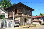 | ||
| Lucio Tanguamos and Petrona Apao House | Misamis Occidental | Jimenez | Burgos St. cor. Spanish road | 8.331938°N 123.839963°E |  | ||
| Misamis Occidental | Jimenez | | |||||
| Marcelo Harayo House | Misamis Occidental | Jimenez | 8.333658°N 123.844501°E |  | |||
| Santiago Cajita House | Misamis Occidental | Jimenez | 8.3336°N 123.844849°E |  | |||
| Sataru Oca and Beatriz Alforque House | Misamis Occidental | Jimenez | Burgos St. | 8.333845°N 123.838928°E |  | ||
| Severino Vapor House | Misamis Occidental | Jimenez | 8.334185°N 123.842108°E |  | |||
| Sofronio Galindo and Bonifacia Cahayag Balais House | Misamis Occidental | Jimenez | 8.333952°N 123.842279°E |  | |||
| Spanish Road | Misamis Occidental | Jimenez | 8.331125°N 123.840264°E |  | |||
| Tim Kian Tiu House | Misamis Occidental | Jimenez | 8.333905°N 123.838567°E |  |
This table lists down built heritage structures not formally identified by the local government of Jimenez but are pursuant to the Republic Act No. 10066 or the National Heritage Law of 2009:


References
- "Municipality". Quezon City, Philippines: Department of the Interior and Local Government. Retrieved 31 May 2013.
- "Province: Misamis Occidental". PSGC Interactive. Quezon City, Philippines: Philippine Statistics Authority. Retrieved 12 November 2016.
- Census of Population (2015). "Region X (Northern Mindanao)". Total Population by Province, City, Municipality and Barangay. PSA. Retrieved 20 June 2016.
- "PSA releases the 2015 Municipal and City Level Poverty Estimates". Quezon City, Philippines. Retrieved 12 October 2019.
- "Jimenez: Average Temperatures and Rainfall". Meteoblue. Retrieved 29 April 2020.
- Census of Population and Housing (2010). "Region X (Northern Mindanao)". Total Population by Province, City, Municipality and Barangay. NSO. Retrieved 29 June 2016.
- Censuses of Population (1903–2007). "Region X (Northern Mindanao)". Table 1. Population Enumerated in Various Censuses by Province/Highly Urbanized City: 1903 to 2007. NSO.
- "Province of Misamis Occidental". Municipality Population Data. Local Water Utilities Administration Research Division. Retrieved 17 December 2016.
External links
- Jimenez Profile at PhilAtlas.com
- Philippine Standard Geographic Code
- Philippine Census Information
- Local Governance Performance Management System
Places adjacent to Jimenez, Misamis Occidental | ||||||||||
|---|---|---|---|---|---|---|---|---|---|---|
| ||||||||||