Impasugong
Impasugong, officially the Municipality of Impasugong, is a 1st class municipality in the province of Bukidnon, Philippines. According to the 2015 census, it has a population of 47,859 people.[4]
Impasugong | |
|---|---|
| Municipality of Impasugong | |
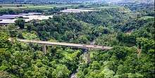
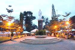 Impasugong Plaza | |
 Seal | |
| Nickname(s): Rodeo Capital of Southern Philippines Home of the Finest Cowboys | |
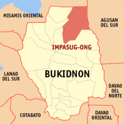 Map of Bukidnon with Impasugong highlighted | |
OpenStreetMap 
| |
.svg.png) Impasugong Location within the Philippines | |
| Coordinates: 8°18′N 125°00′E | |
| Country | |
| Region | Northern Mindanao (Region X) |
| Province | Bukidnon |
| District | 2nd District |
| Founded | June 16, 1950 |
| Barangays | 13 (see Barangays) |
| Government | |
| • Type | Sangguniang Bayan |
| • Mayor | Anthony "Cheche" A. Uy |
| • Vice Mayor | Maria Norly T. Pepito |
| • Congressman | Jonathan Keith T. Flores |
| • Electorate | 27,330 voters (2019) |
| Area | |
| • Total | 1,051.17 km2 (405.86 sq mi) |
| Elevation | 642.2 m (2,107.0 ft) |
| Population (2015 census)[4] | |
| • Total | 47,859 |
| • Density | 46/km2 (120/sq mi) |
| • Households | 9,734 |
| Economy | |
| • Income class | 1st municipal income class |
| • Poverty incidence | 57.98% (2015)[5] |
| • Revenue (₱) | 228,842,041.33 (2016) |
| Time zone | UTC+8 (PST) |
| ZIP code | 8702 |
| PSGC | |
| IDD : area code | +63 (0)88 |
| Climate type | tropical rainforest climate |
| Native languages | Binukid Cebuano Ata Manobo Tagalog |
| Website | www |
It is also spelled Impasug-ong.
Impasug-ong also has a tree park, 15 minutes drive from the centre. The town's communal ranch which has a 642-hectare land area is the only communal ranch solely owned by the government throughout the Philippines.
Geography
Impasugong is strategically located in the north-eastern part of the Province of Bukidnon. It is approximately 75 kilometres (47 mi) from Cagayan de Oro City, a good 1½-hour drive and it is half an hour away from Malaybalay City, the capital of the province.
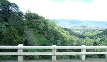
With a total number of 13 barangays, it is characterized by mountains, deep canyons and gorges. The terrain is predominantly rugged with a significant slope of 18% and above covering 72% of the land area and distributed throughout the municipality.
Land area and use
It had a total land area of 105,117 hectares (259,750 acres), or 13% of the total land area of the province. 83% is classified as timberlands and 17% as alienable and disposable (A&D) lands. 72% of this A&D lands is devoted to agricultural production.
Rivers
- Pulangi River, the major source of the Rio Grande de Mindanao river system and also the longest river in bukidnon
- Dampilasan River, first of tributary of Pulangi River
- Atugan River, Main river in the municipality that passes along the Poblacion.
- Tagoloan River, A major River whose mouth is in Misamis Oriental
- Kalabugao River, It is a tributary of Pulangi river in Bukidnon
Climate
Cool and moist throughout the year due to its high elevation ranging from 500 metres (1,600 ft) to more than 1,000 metres (3,300 ft) above sea level. It is a typhoon-free area ideal for the production of high value crops. Average temperature ranges from 16 to 31 °C (61 to 88 °F) throughout the year.
| Climate data for Impasugong, Bukidnon | |||||||||||||
|---|---|---|---|---|---|---|---|---|---|---|---|---|---|
| Month | Jan | Feb | Mar | Apr | May | Jun | Jul | Aug | Sep | Oct | Nov | Dec | Year |
| Average high °C (°F) | 25 (77) |
25 (77) |
26 (79) |
28 (82) |
27 (81) |
27 (81) |
26 (79) |
27 (81) |
27 (81) |
26 (79) |
26 (79) |
26 (79) |
26 (80) |
| Average low °C (°F) | 20 (68) |
19 (66) |
19 (66) |
20 (68) |
21 (70) |
21 (70) |
21 (70) |
21 (70) |
21 (70) |
21 (70) |
21 (70) |
20 (68) |
20 (69) |
| Average precipitation mm (inches) | 152 (6.0) |
103 (4.1) |
80 (3.1) |
79 (3.1) |
185 (7.3) |
275 (10.8) |
292 (11.5) |
319 (12.6) |
298 (11.7) |
275 (10.8) |
195 (7.7) |
120 (4.7) |
2,373 (93.4) |
| Average rainy days | 16.2 | 12.9 | 13.1 | 14.4 | 25.9 | 28.5 | 29.9 | 29.6 | 28.4 | 27.8 | 22.0 | 16.4 | 265.1 |
| Source: Meteoblue [6] | |||||||||||||
Barangays
Impasugong is politically subdivided into 13 barangays.
| PSGC | Barangay | Population | ±% p.a. | |||
|---|---|---|---|---|---|---|
| 2015[4] | 2010[7] | |||||
| 101305001 | Bontongon | 1.7% | 800 | 750 | 1.24% | |
| 101305002 | Bulonay | 3.2% | 1,525 | 1,344 | 2.43% | |
| 101305003 | Capitan Bayong | 6.5% | 3,122 | 2,788 | 2.18% | |
| 101305004 | Cawayan | 4.3% | 2,080 | 1,761 | 3.22% | |
| 101305005 | Dumalaguing | 5.9% | 2,800 | 2,391 | 3.05% | |
| 101305006 | Guihean | 4.4% | 2,128 | 1,837 | 2.84% | |
| 101305007 | Hagpa | 6.0% | 2,859 | 2,573 | 2.03% | |
| 101305008 | Impalutao | 12.9% | 6,183 | 6,078 | 0.33% | |
| 101305010 | Kalabugao | 10.6% | 5,084 | 4,882 | 0.77% | |
| 101305011 | Kibenton | 8.9% | 4,242 | 3,670 | 2.80% | |
| 101305012 | La Fortuna | 9.1% | 4,360 | 4,081 | 1.27% | |
| 101305013 | Poblacion | 23.6% | 11,279 | 10,116 | 2.09% | |
| 101305015 | Sayawan | 2.9% | 1,397 | 1,316 | 1.14% | |
| Total | 47,859 | 43,587 | 1.80% | |||
Demographics
| Population census of Impasugong | ||||||||||||||||||||||||||||||||||||||||||||||
|---|---|---|---|---|---|---|---|---|---|---|---|---|---|---|---|---|---|---|---|---|---|---|---|---|---|---|---|---|---|---|---|---|---|---|---|---|---|---|---|---|---|---|---|---|---|---|
|
| |||||||||||||||||||||||||||||||||||||||||||||
| Source: Philippine Statistics Authority[4][7][8][9] | ||||||||||||||||||||||||||||||||||||||||||||||
In the 2015 census, the population of Impasugong was 47,859 people,[4] with a density of 46 inhabitants per square kilometre or 120 inhabitants per square mile.
Economy
Major crops
The major crops grown by farmers in the municipality are: corn, pineapple, rice, coffee, sugarcane, banana, vegetables (mostly temperate types like lettuce, broccoli, cabbage), abacá, fruits and legumes.
Livestock
There are 9 commercial cattle farms in the area holding 1,143 heads in all. The LGU also manages a communal ranch in a 649-hectare land that holds 300 heads of cattle. This supports the dispersal and breed improvement program of the municipality.
There are also 28 commercial poultry breeder farms in the municipality with an estimated combined population of 775,000 heads.
Ecotourism
CEDAR or Center for Ecological Development and Recreation, situated beside the highway in barangay Impalutao, is the main entity backed by the Local Government Unit of Bukidnon and DENR (Department of Environment and Natural Resources) to promote eco-tourism in the province. It has a total land area of about 1,703 hectares. 373 hectares is covered by the man-made and natural forest. It has an elevation of 600 to 1200 meters above sea level with Mount Kibuwa as the highest. A 100-hectare rattan plantation exists in the area. The CEDAR was developed because of the reforestation efforts of the government of Bukidnon. Now dubbed as “An Eco-tourism Site in the Heart of Bukidnon”, it was declared as a protected area and was managed by the government since 1912. It is equipped with man-made swimming pool, sourcing from the natural springs surrounding the area and has five major waterfalls with three being the most accessible.
References
- "Municipality". Quezon City, Philippines: Department of the Interior and Local Government. Retrieved 31 May 2013.
- "Province: Bukidnon". PSGC Interactive. Quezon City, Philippines: Philippine Statistics Authority. Retrieved 12 November 2016.
- "Impasugong, Bukidnon Profile". PhilAtlas.com. Retrieved 15 June 2020.
- Census of Population (2015). "Region X (Northern Mindanao)". Total Population by Province, City, Municipality and Barangay. PSA. Retrieved 20 June 2016.
- "PSA releases the 2015 Municipal and City Level Poverty Estimates". Quezon City, Philippines. Retrieved 12 October 2019.
- "Impasugong: Average Temperatures and Rainfall". Meteoblue. Retrieved 29 April 2020.
- Census of Population and Housing (2010). "Region X (Northern Mindanao)". Total Population by Province, City, Municipality and Barangay. NSO. Retrieved 29 June 2016.
- Censuses of Population (1903–2007). "Region X (Northern Mindanao)". Table 1. Population Enumerated in Various Censuses by Province/Highly Urbanized City: 1903 to 2007. NSO.
- "Province of Bukidnon". Municipality Population Data. Local Water Utilities Administration Research Division. Retrieved 17 December 2016.
External links
| Wikimedia Commons has media related to Impasug-ong, Bukidnon. |
- Impasug-ong Profile at PhilAtlas.com
- Philippine Standard Geographic Code
- Philippine Census Information
- Official website
Places adjacent to Impasugong | ||||||||||
|---|---|---|---|---|---|---|---|---|---|---|
| ||||||||||