Mueang Maha Sarakham District
Mueang Maha Sarakham District (Thai: เมืองมหาสารคาม) is the capital district (amphoe mueang) of Maha Sarakham Province, northeastern Thailand.
Mueang Maha Sarakham เมืองมหาสารคาม | |
|---|---|
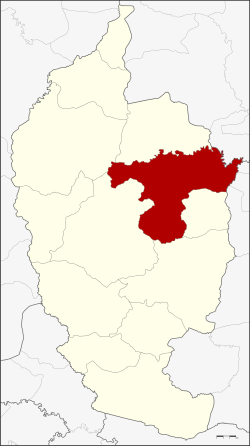 District location in Maha Sarakham Province | |
| Coordinates: 16°11′3″N 103°18′4″E | |
| Country | Thailand |
| Province | Maha Sarakham |
| Area | |
| • Total | 556.7 km2 (214.9 sq mi) |
| Population (2005) | |
| • Total | 142,325 |
| • Density | 255.7/km2 (662/sq mi) |
| Time zone | UTC+7 (ICT) |
| Postal code | 44000 |
| Geocode | 4401 |
Geography
Neighboring districts are (from the south clockwise): Kae Dam, Wapi Pathum, Borabue, Kosum Phisai, and Kantharawichai of Maha Sarakham Province; Khong Chai of Kalasin Province; and Changhan, Mueang Roi Et, and Si Somdet of Roi Et Province.
History
In 1913 the district name was changed from Uthai Sarakham to Mueang Maha Sarakham.[1]
Administration
The district is divided into 14 sub-districts (tambons), which are further subdivided into 182 villages (mubans). The town (thesaban mueang) Maha Sarakham covers the whole of tambon Talat. The township (thesaban tambon) Waeng Nang includes parts of tambon Waeng Nang. There are a further 13 tambon administrative organizations (TAO).
| No. | Name | Thai name | Villages | Pop. | |
|---|---|---|---|---|---|
| 1. | Talat | ตลาด | - | 40,298 | |
| 2. | Khwao | เขวา | 24 | 14,415 | |
| 3. | Tha Tum | ท่าตูม | 10 | 5,346 | |
| 4. | Waeng Nang | แวงน่าง | 17 | 12,997 | |
| 5. | Khok Ko | โคกก่อ | 16 | 8,104 | |
| 6. | Don Wan | ดอนหว่าน | 9 | 4,943 | |
| 7. | Koeng | เกิ้ง | 12 | 7,487 | |
| 8. | Kaeng Loeng Chan | แก่งเลิงจาน | 16 | 7,856 | |
| 9. | Tha Song Khon | ท่าสองคอน | 23 | 13,238 | |
| 10. | Lat Phatthana | ลาดพัฒนา | 19 | 7,650 | |
| 11. | Nong Pling | หนองปลิง | 8 | 5,050 | |
| 12. | Huai Aeng | ห้วยแอ่ง | 10 | 3,566 | |
| 13. | Nong No | หนองโน | 8 | 5,968 | |
| 14. | Bua Kho | บัวค้อ | 10 | 5,407 |
References
- แจ้งความกระทรวงมหาดไทย เรื่อง เปลี่ยนนามอำเภอ (PDF). Royal Gazette (in Thai). 30 (0 ง): 1619–1620. October 19, 1913.