Sino-Indian War
The Sino-Indian War, also known as the Indo-China War and Sino-Indian Border Conflict, was a war between China and India that occurred in 1962. A Chinese disputed Himalayan border was the main cause of the war. There had been a series of violent border skirmishes between the two countries after the 1959 Tibetan uprising, when India granted asylum to the Dalai Lama. India initiated a defensive Forward Policy from 1960 to hinder Chinese military patrols and logistics, in which it placed outposts along the border, including several north of the McMahon Line, the eastern portion of the Line of Actual Control proclaimed by Chinese Premier Zhou Enlai in 1959.[12]
| Sino-Indian War | |||||||
|---|---|---|---|---|---|---|---|
.svg.png) The Sino-Indian War was fought between India and China. | |||||||
| |||||||
| Belligerents | |||||||
|
|
| ||||||
| Commanders and leaders | |||||||
|
Luo Ruiqing (chief of PLA staff)[4] Zhang Guohua (field commander)[4] Mao Zedong (Chairman of the Communist Party of China) Liu Shaoqi (President of the People's Republic of China)[5] Zhou Enlai (Premier of the People's Republic of China) Lin Biao (Vice Chairman of the Communist Party of China) Liu Bocheng (Marshal of PLA) |
Sarvepalli Radhakrishnan (President of India) Jawaharlal Nehru (Prime Minister of India) V. K. Krishna Menon (Defence Minister of India) General Pran Nath Thapar (Chief of Army Staff of the Indian Army) Brij Mohan Kaul (Chief of General Staff of the Indian Army) Lieutenant-General Lionel Protip Sen (GOC-in-C, Eastern Command) Major-General Anant Singh Pathania (GOC 4th Division) | ||||||
| Strength | |||||||
|
|
| ||||||
| Casualties and losses | |||||||
|
Chinese sources:[8][9] 722 killed 1,697 wounded |
Indian sources:[10][11] 4,897 killed or wounded 3,968 captured | ||||||
Chinese military action grew increasingly aggressive after India rejected proposed Chinese diplomatic settlements throughout 1960–1962, with China re-commencing previously-banned "forward patrols" in Ladakh from 30 April 1962.[13][14] China finally abandoned all attempts of peaceful resolution on 20 October 1962, invading disputed territory along the 3,225 kilometre- (2,000-mile-) long Himalayan border in Ladakh and across the McMahon Line.[15] Chinese troops advanced over Indian forces in both theatres, capturing Rezang La in Chushul in the western theatre, as well as Tawang in the eastern theatre. The war ended when China declared a ceasefire on 20 November 1962, and simultaneously announced its withdrawal to its claimed "Line of Actual Control".
Much of the fighting took place in harsh mountain conditions, entailing large-scale combat at altitudes of over 4,000 metres (14,000 feet).[16] The Sino-Indian War was also notable for the lack of deployment of naval and aerial assets by either China or India.
As the Sino-Soviet split heated up, Moscow made a major effort to support India, especially with the sale of advanced MiG fighter-aircraft. The United States and Britain refused to sell advanced weaponry to India, causing it to turn to the Soviet Union.[17]
This was the first war between India and China. Following the end of the war, both sides kept forward armed positions and a number of small clashes broke out, but no large-scale fighting ensued.
Location
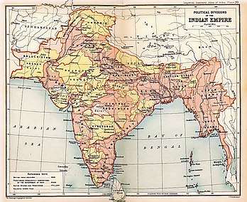
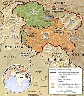
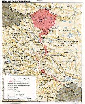
China and India shared a long border, sectioned into three stretches by Nepal, Sikkim (then an Indian protectorate), and Bhutan, which follows the Himalayas between Burma and what was then West Pakistan. A number of disputed regions lie along this border. At its western end is the Aksai Chin region, an area the size of Switzerland, that sits between the Chinese autonomous region of Xinjiang and Tibet (which China declared as an autonomous region in 1965). The eastern border, between Burma and Bhutan, comprises the present Indian state of Arunachal Pradesh (formerly the North-East Frontier Agency). Both of these regions were overrun by China in the 1962 conflict.
Most combat took place at high elevations. The Aksai Chin region is a desert of salt flats around 5,000 metres (16,000 feet) above sea level, and Arunachal Pradesh is mountainous with a number of peaks exceeding 7,000 metres (23,000 feet). The Chinese Army had possession of one of the highest ridges in the regions. The high altitude and freezing conditions also caused logistical and welfare difficulties; in past similar conflicts (such as the Italian Campaign of World War I) harsh conditions have caused more casualties than have enemy actions. The Sino-Indian War was no different, with many troops on both sides succumbing to the freezing cold temperatures.[18]
Background
The main cause of the war was a dispute over the sovereignty of the widely separated Aksai Chin and Arunachal Pradesh border regions. Aksai Chin, claimed by India to belong to Kashmir and by China to be part of Xinjiang, contains an important road link that connects the Chinese regions of Tibet and Xinjiang. China's construction of this road was one of the triggers of the conflict.
Aksai Chin
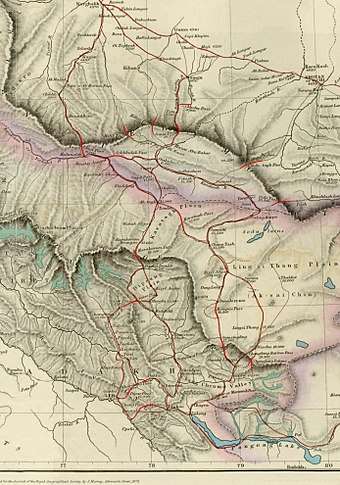
The western portion of the Sino-Indian boundary originated in 1834, with the conquest of Ladakh by the armies of Raja Gulab Singh (Dogra) under the suzerainty of the Sikh Empire. Following an unsuccessful campaign into Tibet, Gulab Singh and the Tibetans signed a treaty in 1842 agreeing to stick to the "old, established frontiers", which were left unspecified.[19][20] The British defeat of the Sikhs in 1846 resulted in the transfer of the Jammu and Kashmir region including Ladakh to the British, who then installed Gulab Singh as the Maharaja under their suzerainty. British commissioners contacted Chinese officials to negotiate the border, who did not show any interest.[21] The British boundary commissioners fixed the southern end of the boundary at Pangong Lake, but regarded the area north of it till the Karakoram Pass as terra incognita.[22]
The Maharaja of Kashmir and his officials were keenly aware of the trade routes from Ladakh. Starting from Leh, there were two main routes into Central Asia: one passed through the Karakoram Pass to Shahidulla at the foot of the Kunlun Mountains and went on to Yarkand through the Kilian and Sanju passes; the other went east via the Chang Chenmo Valley, passed the Lingzi Tang Plains in the Aksai Chin region, and followed the course of the Karakash River to join the first route at Shahidulla.[23] The Maharaja regarded Shahidulla as his northern outpost, in effect treating the Kunlun mountains as the boundary of his domains. His British suzerains were sceptical of such an extended boundary because Shahidulla was 79 miles away from the Karakoram pass and the intervening area was uninhabited. Nevertheless, the Maharaja was allowed to treat Shahidulla as his outpost for more than 20 years.[24][lower-alpha 1][lower-alpha 2]
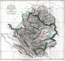
Chinese Turkestan regarded the "northern branch" of the Kunlun range with the Kilian and Sanju passes as its southern boundary. Thus the Maharaja's claim was uncontested.[25][lower-alpha 3] After the 1862 Dungan Revolt, which saw the expulsion of the Chinese from Turkestan, the Maharaja of Kashmir constructed a small fort at Shahidulla in 1864. The fort was most likely supplied from Khotan, whose ruler was now independent and on friendly terms with Kashmir. When the Khotanese ruler was deposed by the Kashgaria strongman Yakub Beg, the Maharaja was forced to abandon his post in 1867. It was then occupied by Yakub Beg's forces until the end of the Dungan Revolt.[26] In the intervening period, W. H. Johnson of Survey of India was commissioned to survey the Aksai Chin region. While in the course of his work, he was "invited" by the Khotanese ruler to visit his capital. After returning, Johnson noted that Khotan's border was at Brinjga, in the Kunlun mountains, and the entire the Karakash Valley was within the territory of Kashmir. The boundary of Kashmir that he drew, stretching from Sanju Pass to the eastern edge of Chang Chenmo Valley along the Kunlun mountains, is referred to as the "Johnson Line" (or "Ardagh-Johnson Line").[27][lower-alpha 4]
After the Chinese reconquered Turkestan in 1878, renaming it Xinjiang, they again reverted to their traditional boundary. By now, the Russian Empire was entrenched in Central Asia, and the British were anxious to avoid a common border with the Russians. After creating the Wakhan corridor as the buffer in the northwest of Kashmir, they wanted the Chinese to fill out the "no man's land" between the Karakoram and Kunlun ranges. Under British (and possibly Russian) encouragement, the Chinese occupied the area up to the Yarkand River valley (called Raskam), including Shahidulla, by 1890.[30] They also erected a boundary pillar at the Karakoram pass by about 1892.[31] These efforts appear half-hearted. A map provided by Hung Ta-chen, a senior Chinese official at St. Petersburgh, in 1893 showed the boundary of Xinjiang up to Raskam. In the east, it was similar to the Johnson line, placing Aksai Chin in Kashmir territory.[32]
By 1892, the British settled on the policy that their preferred boundary for Kashmir was the "Indus watershed", i.e., the water-parting from which waters flow into the Indus river system on one side and into the Tarim basin on the other. In the north, this water-parting was along the Karakoram range. In the east, it was more complicated because the Chip Chap River, Galwan River and the Chang Chenmo River flow into the Indus whereas the Karakash River flows into the Tarim basin.[33] A boundary alignment along this water-parting was defined by the Viceroy Lord Elgin and communicated to London. The British government in due course proposed it to China via its envoy Sir Claude MacDonald in 1899. This boundary, which came to be called the Macartney–MacDonald Line, ceded to China the Aksai Chin plains in the northeast, and the Trans-Karakoram Tract in the north. In return, the British wanted China to cede its 'shadowy suzerainty' on Hunza.[34][lower-alpha 5]
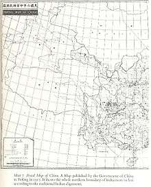
In 1911 the Xinhai Revolution resulted in power shifts in China, and by the end of World War I, the British officially used the Johnson Line. They took no steps to establish outposts or assert control on the ground.[16] According to Neville Maxwell, the British had used as many as 11 different boundary lines in the region, as their claims shifted with the political situation.[36] From 1917 to 1933, the "Postal Atlas of China", published by the Government of China in Peking had shown the boundary in Aksai Chin as per the Johnson line, which runs along the Kunlun mountains.[37][38] The "Peking University Atlas", published in 1925, also put the Aksai Chin in India.[39] Upon independence in 1947, the government of India used the Johnson Line as the basis for its official boundary in the west, which included the Aksai Chin.[16] On 1 July 1954, India's first Prime Minister Jawaharlal Nehru definitively stated the Indian position,[28] claiming that Aksai Chin had been part of the Indian Ladakh region for centuries, and that the border (as defined by the Johnson Line) was non-negotiable.[40] According to George N. Patterson, when the Indian government finally produced a report detailing the alleged proof of India's claims to the disputed area, "the quality of the Indian evidence was very poor, including some very dubious sources indeed".[41]:275
In 1956–57, China constructed a road through Aksai Chin, connecting Xinjiang and Tibet, which ran south of the Johnson Line in many places.[16][40] Aksai Chin was easily accessible to the Chinese, but access from India, which meant negotiating the Karakoram mountains, was much more difficult.[40] The road came on Chinese maps published in 1958.[4]
The McMahon Line
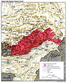
In 1826, British India gained a common border with China after the British wrested control of Manipur and Assam from the Burmese, following the First Anglo-Burmese War of 1824–1826. In 1847, Major J. Jenkins, agent for the North East Frontier, reported that the Tawang was part of Tibet. In 1872, four monastic officials from Tibet arrived in Tawang and supervised a boundary settlement with Major R. Graham, NEFA official, which included the Tawang Tract as part of Tibet. Thus, in the last half of the 19th century, it was clear that the British treated the Tawang Tract as part of Tibet. This boundary was confirmed in a 1 June 1912 note from the British General Staff in India, stating that the "present boundary (demarcated) is south of Tawang, running westwards along the foothills from near Udalguri, Darrang to the southern Bhutanese border and Tezpur claimed by China."[16] A 1908 map of The Province of Eastern Bengal and Assam prepared for the Foreign Department of the Government of India, showed the international boundary from Bhutan continuing to the Baroi River, following the Himalayas foothill alignment.[16] In 1913, representatives of the UK, China and Tibet attended a conference in Simla regarding the borders between Tibet, China and British India. Whilst all three representatives initialed the agreement, Beijing later objected to the proposed boundary between the regions of Outer Tibet and Inner Tibet, and did not ratify it. The details of the Indo-Tibetan boundary was not revealed to China at the time.[16] The foreign secretary of the British Indian government, Henry McMahon, who had drawn up the proposal, decided to bypass the Chinese (although instructed not to by his superiors) and settle the border bilaterally by negotiating directly with Tibet.[40] According to later Indian claims, this border was intended to run through the highest ridges of the Himalayas, as the areas south of the Himalayas were traditionally Indian.[42] The McMahon Line lay south of the boundary India claims.[40] India's government held the view that the Himalayas were the ancient boundaries of the Indian subcontinent, and thus should be the modern boundaries of India,[42] while it is the position of the Chinese government that the disputed area in the Himalayas have been geographically and culturally part of Tibet since ancient times.[43]
Months after the Simla agreement, China set up boundary markers south of the McMahon Line. T. O'Callaghan, an official in the Eastern Sector of the North East Frontier, relocated all these markers to a location slightly south of the McMahon Line, and then visited Rima to confirm with Tibetan officials that there was no Chinese influence in the area.[16] The British-run Government of India initially rejected the Simla Agreement as incompatible with the Anglo-Russian Convention of 1907, which stipulated that neither party was to negotiate with Tibet "except through the intermediary of the Chinese government".[44] The British and Russians cancelled the 1907 agreement by joint consent in 1921.[45] It was not until the late 1930s that the British started to use the McMahon Line on official maps of the region.
China took the position that the Tibetan government should not have been allowed to make such a treaty, rejecting Tibet's claims of independent rule.[40] For its part, Tibet did not object to any section of the McMahon Line excepting the demarcation of the trading town of Tawang, which the Line placed under British-Indian jurisdiction.[40] Up until World War II, Tibetan officials were allowed to administer Tawang with complete authority. Due to the increased threat of Japanese and Chinese expansion during this period, British Indian troops secured the town as part of the defence of India's eastern border.[16]
In the 1950s, India began patrolling the region. It found that, at multiple locations, the highest ridges actually fell north of the McMahon Line.[40] Given India's historic position that the original intent of the line was to separate the two nations by the highest mountains in the world, in these locations India extended its forward posts northward to the ridges, regarding this move as compliant with the original border proposal, although the Simla Convention did not explicitly state this intention.[40]
Events leading up to war
Tibet and the border dispute
The 1940s saw huge change with the Partition of India in 1947 (resulting in the establishment of the two new states of India and Pakistan), and the establishment of the People's Republic of China (PRC) after the Chinese Civil War in 1949. One of the most basic policies for the new Indian government was that of maintaining cordial relations with China, reviving its ancient friendly ties. India was among the first nations to grant diplomatic recognition to the newly created PRC.[46]
At the time, Chinese officials issued no condemnation of Nehru's claims or made any opposition to Nehru's open declarations of control over Aksai Chin. In 1956, Chinese Premier Zhou Enlai stated that he had no claims over Indian-controlled territory.[46] He later argued that Aksai Chin was already under Chinese jurisdiction and that the McCartney-MacDonald Line was the line China could accept.[38][40] Zhou later argued that as the boundary was undemarcated and had never been defined by treaty between any Chinese or Indian government, the Indian government could not unilaterally define Aksai Chin's borders.[36]
In 1950, the Chinese People's Liberation Army took control of Tibet, which all Chinese governments regarded as still part of China. Later the Chinese extended their influence by building a road in 1956–67[16] and placing border posts in Aksai Chin.[47] India found out after the road was completed, protested against these moves and decided to look for a diplomatic solution to ensure a stable Sino-Indian border.[46] To resolve any doubts about the Indian position, Prime Minister Jawaharlal Nehru declared in parliament that India regarded the McMahon Line as its official border.[46] The Chinese expressed no concern at this statement,[46] and in 1961 and 1962, the government of China asserted that there were no frontier issues to be taken up with India.[46]
In 1954, Prime Minister Nehru wrote a memo calling for India's borders to be clearly defined and demarcated;[28] in line with previous Indian philosophy, Indian maps showed a border that, in some places, lay north of the McMahon Line.[48] Chinese Premier Zhou Enlai, in November 1956, again repeated Chinese assurances that the People's Republic had no claims on Indian territory, although official Chinese maps showed 120,000 square kilometres (46,000 sq mi) of territory claimed by India as Chinese.[46] CIA documents created at the time revealed that Nehru had ignored Burmese premier Ba Swe when he warned Nehru to be cautious when dealing with Zhou.[49] They also allege that Zhou purposefully told Nehru that there were no border issues with India.[49]
In 1954, China and India negotiated the Five Principles of Peaceful Coexistence, by which the two nations agreed to abide in settling their disputes. India presented a frontier map which was accepted by China, and the slogan Hindi-Chini bhai-bhai (Indians and Chinese are brothers) was popular then. Nehru in 1958 had privately told G. Parthasarathi, the Indian envoy to China not to trust the Chinese at all and send all communications directly to him, bypassing the Defence Minister VK Krishna Menon since his communist background clouded his thinking about China.[50] According to Georgia Tech scholar John W Garver, Nehru's policy on Tibet was to create a strong Sino-Indian partnership which would be catalysed through agreement and compromise on Tibet. Garver believes that Nehru's previous actions had given him confidence that China would be ready to form an "Asian Axis" with India.[4]
This apparent progress in relations suffered a major setback when, in 1959, Nehru accommodated the Tibetan religious leader at the time, the 14th Dalai Lama, who fled Lhasa after a failed Tibetan uprising against Chinese rule. The Chairman of the Communist Party of China, Mao Zedong, was enraged and asked the Xinhua News Agency to produce reports on Indian expansionists operating in Tibet.
Border incidents continued through this period. In August 1959, the People's Liberation Army took an Indian prisoner at Longju, which had an ambiguous position in the McMahon Line,[16][48][51] and two months later in Aksai Chin, a clash at Kongka Pass led to the death of nine Indian frontier policemen.[47]
On 2 October, Soviet Premier Nikita Khrushchev defended Nehru in a meeting with Chairman Mao. This action reinforced China's impression that the Soviet Union, the United States and India all had expansionist designs on China. The People's Liberation Army went so far as to prepare a self-defence counterattack plan.[4] Negotiations were restarted between the nations, but no progress was made.[28][52]
As a consequence of their non-recognition of the McMahon Line, China's maps showed both the North East Frontier Area (NEFA) and Aksai Chin to be Chinese territory.[42] In 1960, Zhou Enlai unofficially suggested that India drop its claims to Aksai Chin in return for a Chinese withdrawal of claims over NEFA. Adhering to his stated position, Nehru believed that China did not have a legitimate claim over either of these territories, and thus was not ready to concede them. This adamant stance was perceived in China as Indian opposition to Chinese rule in Tibet.[4] Nehru declined to conduct any negotiations on the boundary until Chinese troops withdrew from Aksai Chin, a position supported by the international community.[40] India produced numerous reports on the negotiations, and translated Chinese reports into English to help inform the international debate. China believed that India was simply securing its claim lines in order to continue its "grand plans in Tibet".[4] India's stance that China withdraw from Aksai Chin caused continual deterioration of the diplomatic situation to the point that internal forces were pressuring Nehru to take a military stance against China.
1960 meetings to resolve the boundary question
In 1960, based on an agreement between Nehru and Zhou Enlai, officials from India and China held discussions in order to settle the boundary dispute.[53][54] China and India disagreed on the major watershed that defined the boundary in the western sector.[55] The Chinese statements with respect to their border claims often misrepresented the cited sources.[56] The failure of these negotiations was compounded by successful Chinese border agreements with Nepal (Sino-Nepalese Treaty of Peace and Friendship) and Burma in the same year.[57]
The Forward Policy
At the beginning of 1961, Nehru appointed General B. M. Kaul as army Chief of General Staff,[58] but he refused to increase military spending and prepare for a possible war.[58] According to James Barnard Calvin of the U.S. Navy, in 1959, India started sending Indian troops and border patrols into disputed areas. This program created both border skirmishes and deteriorating relations between India and China.[16] The aim of this policy was to create outposts behind advancing Chinese troops to interdict their supplies, forcing them north of the disputed line.[16][46][51][59][60][61] There were eventually 60 such outposts, including 43 north of the McMahon Line, to which India claimed sovereignty.[16][28] China viewed this as further confirmation of Indian expansionist plans directed towards Tibet. According to the Indian official history, implementation of the Forward Policy was intended to provide evidence of Indian occupation in the previously unoccupied region through which Chinese troops had been advancing. Kaul was confident, through contact with Indian Intelligence and CIA information, that China would not react with force.[40] Indeed, at first the PLA simply withdrew, but eventually Chinese forces began to counter-encircle the Indian positions which clearly encroached into the north of McMahon Line. This led to a tit-for-tat Indian reaction, with each force attempting to outmanoeuver the other. Despite the escalating nature of the dispute, the two forces withheld from engaging each other directly.[4]
Chinese attention was diverted for a time by the military activity of the Nationalists on Taiwan, but on 23 June the U.S. assured China that a Nationalist invasion would not be permitted.[62] China's heavy artillery facing Taiwan could then be moved to Tibet.[63] It took China six to eight months to gather the resources needed for the war, according to Anil Athale, author of the official Indian history.[63] The Chinese sent a large quantity of non-military supplies to Tibet through the Indian port of Calcutta.[63]
Early incidents
Various border conflicts and "military incidents" between India and China flared up throughout the summer and autumn of 1962. In May, the Indian Air Force was told not to plan for close air support, although it was assessed as being a feasible way to counter the unfavourable ratio of Chinese to Indian troops.[64] In June, a skirmish caused the deaths of dozens of Chinese troops. The Indian Intelligence Bureau received information about a Chinese buildup along the border which could be a precursor to war.[64]
During June–July 1962, Indian military planners began advocating "probing actions" against the Chinese, and accordingly, moved mountain troops forward to cut off Chinese supply lines. According to Patterson, the Indian motives were threefold:
- Test Chinese resolve and intentions regarding India.
- Test whether India would enjoy Soviet backing in the event of a Sino-Indian war.
- Create sympathy for India within the U.S., with whom relations had deteriorated after the Indian annexation of Goa.[41]:279
On 10 July 1962, 350 Chinese troops surrounded an Indian post in Chushul (north of the McMahon Line) but withdrew after a heated argument via loudspeaker.[18] On 22 July, the Forward Policy was extended to allow Indian troops to push back Chinese troops already established in disputed territory.[46] Whereas Indian troops were previously ordered to fire only in self-defence, all post commanders were now given discretion to open fire upon Chinese forces if threatened.[46] In August, the Chinese military improved its combat readiness along the McMahon Line and began stockpiling ammunition, weapons and fuel.[16]
Given his foreknowledge of the coming Cuban Missile Crisis, Mao Zedong was able to persuade Nikita Khrushchev, First Secretary of the Communist Party of the Soviet Union, to reverse the Russian policy of backing India, at least temporarily.[65] In mid-October, the Communist organ Pravda encouraged peace between India and China.[65] When the Cuban Missile Crisis ended and Mao's rhetoric changed, Russia reversed course.[65]
Confrontation at Thag La
In June 1962, Indian forces established an outpost at Dhola, on the southern slopes of the Thag La Ridge.[16] Dhola lay north of the McMahon Line but south of the ridges along which India interpreted the McMahon Line to run.[40][48][66] In August, China issued diplomatic protests and began occupying positions at the top of Thag La.[4][16] On 8 September, a 60-strong PLA unit descended to the south side of the ridge and occupied positions that dominated one of the Indian posts at Dhola. Fire was not exchanged, but Nehru said to the media that the Indian Army had instructions to "free our territory" and the troops had been given discretion to use force.[4] On 11 September, it was decided that "all forward posts and patrols were given permission to fire on any armed Chinese who entered Indian territory".[46]
The operation to occupy Thag La was flawed in that Nehru's directives were unclear and it got underway very slowly because of this.[16][40] In addition to this, each man had to carry 35 kilograms (77 lb) over the long trek and this severely slowed down the reaction.[67] By the time the Indian battalion reached the point of conflict, Chinese units controlled both banks of the Namka Chu River.[16] On 20 September, Chinese troops threw grenades at Indian troops and a firefight developed, triggering a long series of skirmishes for the rest of September.[16][67]
Some Indian troops, including Brigadier Dalvi who commanded the forces at Thag La, were also concerned that the territory they were fighting for was not strictly territory that "we should have been convinced was ours".[51] According to Neville Maxwell, even members of the Indian defence ministry were categorically concerned with the validity of the fighting in Thag La.[40]
On 4 October, Kaul assigned some troops to secure regions south of the Thag La Ridge.[16] Kaul decided to first secure Yumtso La, a strategically important position, before re-entering the lost Dhola post.[46] Kaul had then realised that the attack would be desperate and the Indian government tried to stop an escalation into all-out war. Indian troops marching to Thag La had suffered in the previously unexperienced conditions; two Gurkha soldiers died of pulmonary edema.[67]
On 10 October, an Indian Rajput patrol of 50 troops to Yumtso La were met by an emplaced Chinese position of some 1,000 soldiers.[16] Indian troops were in no position for battle, as Yumtso La was 16,000 feet (4,900 m) above sea level and Kaul did not plan on having artillery support for the troops.[67] The Chinese troops opened fire on the Indians under their belief that they were north of the McMahon Line. The Indians were surrounded by Chinese positions which used mortar fire. They managed to hold off the first Chinese assault, inflicting heavy casualties.[16]
At this point, the Indian troops were in a position to push the Chinese back with mortar and machine gun fire. Brigadier Dalvi opted not to fire, as it would mean decimating the Rajput who were still in the area of the Chinese regrouping. They helplessly watched the Chinese ready themselves for a second assault.[67] In the second Chinese assault, the Indians began their retreat, realising the situation was hopeless. The Indian patrol suffered 25 casualties, and the Chinese 33. The Chinese troops held their fire as the Indians retreated, and then buried the Indian dead with military honours, as witnessed by the retreating soldiers. This was the first occurrence of heavy fighting in the war.[16]
This attack had grave implications for India and Nehru tried to solve the issue, but by 18 October, it was clear that the Chinese were preparing for an attack, with a massive troop buildup.[16] A long line of mules and porters had also been observed supporting the buildup and reinforcement of positions south of the Thag La Ridge.[67]
Chinese and Indian preparations
Chinese motives
Two of the major factors leading up to China's eventual conflicts with Indian troops were India's stance on the disputed borders and perceived Indian subversion in Tibet. There was "a perceived need to punish and end perceived Indian efforts to undermine Chinese control of Tibet, Indian efforts which were perceived as having the objective of restoring the pre-1949 status quo ante of Tibet". The other was "a perceived need to punish and end perceived Indian aggression against Chinese territory along the border". John W. Garver argues that the first perception was incorrect based on the state of the Indian military and polity in the 1960s. It was, nevertheless a major reason for China's going to war. He argues that while the Chinese perception of Indian border actions were "substantially accurate", Chinese perceptions of the supposed Indian policy towards Tibet were "substantially inaccurate".[4]
The CIA's declassified POLO documents reveal contemporary American analysis of Chinese motives during the war. According to this document, "Chinese apparently were motivated to attack by one primary consideration — their determination to retain the ground on which PLA forces stood in 1962 and to punish the Indians for trying to take that ground". In general terms, they tried to show the Indians once and for all that China would not acquiesce in a military "reoccupation" policy. Secondary reasons for the attack were to damage Nehru's prestige by exposing Indian weakness and[49] to expose as traitorous Khrushchev's policy of supporting Nehru against a Communist country.[49]
Another factor which might have affected China's decision for war with India was a perceived need to stop a Soviet-U.S.-India encirclement and isolation of China.[4] India's relations with the Soviet Union and United States were both strong at this time, but the Soviets (and Americans) were preoccupied by the Cuban Missile Crisis and would not interfere with the Sino-Indian War.[16] P. B. Sinha suggests that China waited until October to attack because the timing of the war was exactly in parallel with American actions so as to avoid any chance of American or Soviet involvement. Although American buildup of forces around Cuba occurred on the same day as the first major clash at Dhola, and China's buildup between 10 and 20 October appeared to coincide exactly with the United States establishment of a blockade against Cuba which began 20 October, the Chinese probably prepared for this before they could anticipate what would happen in Cuba.[46] Another explanation is that the confrontation in the Taiwan Strait had eased by then.
Garver argues that the Chinese correctly assessed Indian border policies, particularly the Forward Policy, as attempts for incremental seizure of Chinese-controlled territory. On Tibet, Garver argues that one of the major factors leading to China's decision for war with India was a common tendency of humans "to attribute others' behavior to interior motivations, while attributing their own behavior to situational factors". Studies from China published in the 1990s confirmed that the root cause for China going to war with India was the perceived Indian aggression in Tibet, with the forward policy simply catalysing the Chinese reaction.[4]
Neville Maxwell and Allen Whiting argue that the Chinese leadership believed they were defending territory that was legitimately Chinese, and which was already under de facto Chinese occupation prior to Indian advances, and regarded the Forward Policy as an Indian attempt at creeping annexation.[4] Mao Zedong himself compared the Forward Policy to a strategic advance in Chinese chess:
Their [India's] continually pushing forward is like crossing the Chu Han boundary. What should we do? We can also set out a few pawns, on our side of the river. If they don't then cross over, that’s great. If they do cross, we'll eat them up [chess metaphor meaning to take the opponent's pieces]. Of course, we cannot blindly eat them. Lack of forbearance in small matters upsets great plans. We must pay attention to the situation.[4]
India claims that the motive for the Forward Policy was to cut off the supply routes for Chinese troops posted in NEFA and Aksai Chin.[16] According to the official Indian history, the forward policy was continued because of its initial success, as it claimed that Chinese troops withdrew when they encountered areas already occupied by Indian troops. It also claimed that the Forward Policy was having success in cutting out supply lines of Chinese troops who had advanced South of the McMahon Line, though there was no evidence of such advance before the 1962 war. The Forward Policy rested on the assumption that Chinese forces "were not likely to use force against any of our posts, even if they were in a position to do so". No serious re-appraisal of this policy took place even when Chinese forces ceased withdrawing.[46] Nehru's confidence was probably justified given the difficulty for China to supply the area over the high altitude terrain over 5000 km (3000 miles) from the more populated areas of China.
Chinese policy toward India, therefore, operated on two seemingly contradictory assumptions in the first half of 1961. On the one hand, the Chinese leaders continued to entertain a hope, although a shrinking one, that some opening for talks would appear. On the other hand, they read Indian statements and actions as clear signs that Nehru wanted to talk only about a Chinese withdrawal. Regarding the hope, they were willing to negotiate and tried to prod Nehru into a similar attitude. Regarding Indian intentions, they began to act politically and to build a rationale based on the assumption that Nehru already had become a lackey of imperialism; for this reason he opposed border talks.[49]
Krishna Menon is reported to have said that when he arrived in Geneva on 6 June 1961 for an international conference in Laos, Chinese officials in Chen Yi's delegation indicated that Chen might be interested in discussing the border dispute with him. At several private meetings with Menon, Chen avoided any discussion of the dispute and Menon surmised that the Chinese wanted him to broach the matter first. He did not, as he was under instructions from Nehru to avoid taking the initiative, leaving the Chinese with the impression that Nehru was unwilling to show any flexibility.[49]
In September, the Chinese took a step toward criticising Nehru openly in their commentary. After citing Indonesian and Burmese press criticism of Nehru by name, the Chinese critiqued his moderate remarks on colonialism (People's Daily Editorial, 9 September): "Somebody at the Non-Aligned Nations Conference advanced the argument that the era of classical colonialism is gone and dead...contrary to facts." This was a distortion of Nehru's remarks but appeared close enough to be credible. On the same day, Chen Yi referred to Nehru by implication at the Bulgarian embassy reception: "Those who attempted to deny history, ignore reality, and distort the truth and who attempted to divert the Conference from its important object have failed to gain support and were isolated." On 10 September, they dropped all circumlocutions and criticised him by name in a China Youth article and NCNA report—the first time in almost two years that they had commented extensively on the Prime Minister.[49]
By early 1962, the Chinese leadership began to believe that India's intentions were to launch a massive attack against Chinese troops, and that the Indian leadership wanted a war.[4][16] In 1961, the Indian army had been sent into Goa, a small region without any other international borders apart from the Indian one, after Portugal refused to surrender the exclave colony to the Indian Union. Although this action met little to no international protest or opposition, China saw it as an example of India's expansionist nature, especially in light of heated rhetoric from Indian politicians. India's Home Minister declared, "If the Chinese will not vacate the areas occupied by it, India will have to repeat what it did in Goa. India will certainly drive out the Chinese forces",[16] while another member of the Indian Congress Party pronounced, "India will take steps to end [Chinese] aggression on Indian soil just as it ended Portuguese aggression in Goa".[41] By mid-1962, it was apparent to the Chinese leadership that negotiations had failed to make any progress, and the Forward Policy was increasingly perceived as a grave threat as Delhi increasingly sent probes deeper into border areas and cut off Chinese supply lines.[41] Foreign Minister Marshal Chen Yi commented at one high-level meeting, "Nehru's forward policy is a knife. He wants to put it in our heart. We cannot close our eyes and await death."[4] The Chinese leadership believed that their restraint on the issue was being perceived by India as weakness, leading to continued provocations, and that a major counterblow was needed to stop perceived Indian aggression.[4]
Xu Yan, prominent Chinese military historian and professor at the PLA's National Defense University, gives an account of the Chinese leadership's decision to go to war. By late September 1962, the Chinese leadership had begun to reconsider their policy of "armed coexistence", which had failed to address their concerns with the forward policy and Tibet, and consider a large, decisive strike.[4] On 22 September 1962, the People's Daily published an article which claimed that "the Chinese people were burning with 'great indignation' over the Indian actions on the border and that New Delhi could not 'now say that warning was not served in advance'."[68][69]
Military planning
The Indian side was confident war would not be triggered and made little preparations. India had only two divisions of troops in the region of the conflict.[70] In August 1962, Brigadier D. K. Palit claimed that a war with China in the near future could be ruled out.[70] Even in September 1962, when Indian troops were ordered to "expel the Chinese" from Thag La, Maj. General J. S. Dhillon expressed the opinion that "experience in Ladakh had shown that a few rounds fired at the Chinese would cause them to run away."[4][46] Because of this, the Indian army was completely unprepared when the attack at Yumtso La occurred.[16][70]
Recently declassified CIA documents which were compiled at the time reveal that India's estimates of Chinese capabilities made them neglect their military in favour of economic growth.[71] It is claimed that if a more military-minded man had been in place instead of Nehru, India would have been more likely to have been ready for the threat of a counter-attack from China.[71]
On 6 October 1962, the Chinese leadership convened. Lin Biao reported that PLA intelligence units had determined that Indian units might assault Chinese positions at Thag La on 10 October (Operation Leghorn). The Chinese leadership and the Central Military Council decided upon war to launch a large-scale attack to punish perceived military aggression from India.[4] In Beijing, a larger meeting of Chinese military was convened in order to plan for the coming conflict.[4]
Mao and the Chinese leadership issued a directive laying out the objectives for the war. A main assault would be launched in the eastern sector, which would be coordinated with a smaller assault in the western sector. All Indian troops within China's claimed territories in the eastern sector would be expelled, and the war would be ended with a unilateral Chinese ceasefire and withdrawal, followed by a return to the negotiating table.[4] India led the Non-Aligned Movement, Nehru enjoyed international prestige, and China, with a larger military, would be portrayed as an aggressor. He said that a well-fought war "will guarantee at least thirty years of peace" with India, and determined the benefits to offset the costs.[4]
China also reportedly bought a significant amount of Indian rupee currency from Hong Kong, supposedly to distribute amongst its soldiers in preparation for the war.[72]
On 8 October, additional veteran and elite divisions were ordered to prepare to move into Tibet from the Chengdu and Lanzhou military regions.[4]
On 12 October, Nehru declared that he had ordered the Indian army to "clear Indian territory in the NEFA of Chinese invaders" and personally met with Kaul, issuing instructions to him.
On 14 October, an editorial on People's Daily issued China's final warning to India: "So it seems that Mr. Nehru has made up his mind to attack the Chinese frontier guards on an even bigger scale. ... It is high time to shout to Mr. Nehru that the heroic Chinese troops, with the glorious tradition of resisting foreign aggression, can never be cleared by anyone from their own territory ... If there are still some maniacs who are reckless enough to ignore our well-intentioned advice and insist on having another try, well, let them do so. History will pronounce its inexorable verdict ... At this critical moment ... we still want to appeal once more to Mr. Nehru: better rein in at the edge of the precipice and do not use the lives of Indian troops as stakes in your gamble."[69]
Marshal Liu Bocheng headed a group to determine the strategy for the war. He concluded that the opposing Indian troops were among India's best, and to achieve victory would require deploying crack troops and relying on force concentration to achieve decisive victory. On 16 October, this war plan was approved, and on the 18th, the final approval was given by the Politburo for a "self-defensive counter-attack", scheduled for 20 October.[4]
Chinese offensive
On 20 October 1962, the Chinese People's Liberation Army launched two attacks, 1000 kilometres (600 miles) apart. In the western theatre, the PLA sought to expel Indian forces from the Chip Chap valley in Aksai Chin while in the eastern theatre, the PLA sought to capture both banks of the Namka Chu river. Some skirmishes also took place at the Nathula Pass, which is in the Indian state of Sikkim (an Indian protectorate at that time). Gurkha rifles travelling north were targeted by Chinese artillery fire. After four days of fierce fighting, the three regiments of Chinese troops succeeded in securing a substantial portion of the disputed territory.[16]
Eastern theatre
Chinese troops launched an attack on the southern banks of the Namka Chu River on 20 October.[67] The Indian forces were undermanned, with only an understrength battalion to support them, while the Chinese troops had three regiments positioned on the north side of the river.[67] The Indians expected Chinese forces to cross via one of five bridges over the river and defended those crossings.[16] The PLA bypassed the defenders by fording the river, which was shallow at that time of year, instead. They formed up into battalions on the Indian-held south side of the river under cover of darkness, with each battalion assigned against a separate group of Rajputs.[67]
At 5:14 am, Chinese mortar fire began attacking the Indian positions. Simultaneously, the Chinese cut the Indian telephone lines, preventing the defenders from making contact with their headquarters. At about 6:30 am, the Chinese infantry launched a surprise attack from the rear and forced the Indians to leave their trenches.[67]
The Chinese overwhelmed the Indian troops in a series of flanking manoeuvres south of the McMahon Line and prompted their withdrawal from Namka Chu.[67] Fearful of continued losses, Indian troops retreated into Bhutan. Chinese forces respected the border and did not pursue.[16] Chinese forces now held all of the territory that was under dispute at the time of the Thag La confrontation, but they continued to advance into the rest of NEFA.[67]
On 22 October, at 12:15 am, PLA mortars fired on Walong, on the McMahon line.[73] Flares launched by Indian troops the next day revealed numerous Chinese milling around the valley.[73] The Indians tried to use their mortars against the Chinese but the PLA responded by lighting a bush fire, causing confusion among the Indians. Some 400 Chinese troops attacked the Indian position. The initial Chinese assault was halted by accurate Indian mortar fire. The Chinese were then reinforced and launched a second assault. The Indians managed to hold them back for four hours, but the Chinese used weight of numbers to break through. Most Indian forces were withdrawn to established positions in Walong, while a company supported by mortars and medium machine guns remained to cover the retreat.[73]
Elsewhere, Chinese troops launched a three-pronged attack on Tawang, which the Indians evacuated without any resistance.[16]
Over the following days, there were clashes between Indian and Chinese patrols at Walong as the Chinese rushed in reinforcements. On 25 October, the Chinese made a probe, which was met with resistance from the 4th Sikhs. The following day, a patrol from the 4th Sikhs was encircled, and after being unable to break the encirclement, an Indian unit was able to flank the Chinese, allowing the Sikhs to break free.[73]
Western theatre
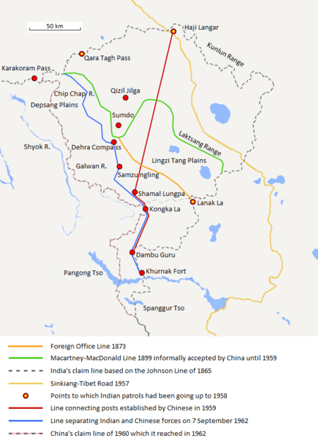
On the Aksai Chin front, China already controlled most of the disputed territory. Chinese forces quickly swept the region of any remaining Indian troops.[74] Late on 19 October, Chinese troops launched a number of attacks throughout the western theatre.[18] By 22 October, all posts north of Chushul had been cleared.[18]
On 20 October, the Chinese easily took the Chip Chap Valley, Galwan Valley, and Pangong Lake.[8] Many outposts and garrisons along the Western front were unable to defend against the surrounding Chinese troops. Most Indian troops positioned in these posts offered resistance but were either killed or taken prisoner. Indian support for these outposts was not forthcoming, as evidenced by the Galwan post, which had been surrounded by enemy forces in August, but no attempt made to relieve the besieged garrison. Following the 20 October attack, nothing was heard from Galwan.[16]
On 24 October, Indian forces fought hard to hold the Rezang La Ridge, in order to prevent a nearby airstrip from falling.[75]
After realising the magnitude of the attack, the Indian Western Command withdrew many of the isolated outposts to the south-east. Daulet Beg Oldi was also evacuated, but it was south of the Chinese claim line and was not approached by Chinese forces. Indian troops were withdrawn in order to consolidate and regroup in the event that China probed south of their claim line.[16]
Lull in the fighting
By 24 October, the PLA had entered territory previously administered by India to give the PRC a diplomatically strong position over India. The majority of Chinese forces had advanced sixteen kilometres (10 miles) south of the control line prior to the conflict. Four days of fighting were followed by a three-week lull. Zhou ordered the troops to stop advancing as he attempted to negotiate with Nehru. The Indian forces had retreated into more heavily fortified positions around Se La and Bomdi La which would be difficult to assault.[16] Zhou sent Nehru a letter, proposing
- A negotiated settlement of the boundary
- That both sides disengage and withdraw twenty kilometres (12 miles) from present lines of actual control
- A Chinese withdrawal north in NEFA
- That China and India not cross lines of present control in Aksai Chin.[16][76]
Nehru's 27 October reply expressed interest in the restoration of peace and friendly relations and suggested a return to the "boundary prior to 8 September 1962". He was categorically concerned about a mutual twenty kilometre (12-mile) withdrawal after "40 or 60 kilometres (25 or 40 miles) of blatant military aggression". He wanted the creation of a larger immediate buffer zone and thus resist the possibility of a repeat offensive. Zhou's 4 November reply repeated his 1959 offer to return to the McMahon Line in NEFA and the Chinese traditionally claimed MacDonald Line in Aksai Chin. Facing Chinese forces maintaining themselves on Indian soil and trying to avoid political pressure, the Indian parliament announced a national emergency and passed a resolution which stated their intent to "drive out the aggressors from the sacred soil of India". The United States and the United Kingdom supported India's response. The Soviet Union was preoccupied with the Cuban Missile Crisis and did not offer the support it had provided in previous years. With the backing of other great powers, a 14 November letter by Nehru to Zhou once again rejected his proposal.[16]
Neither side declared war, used their air force, or fully broke off diplomatic relations, but the conflict is commonly referred to as a war. This war coincided with the Cuban Missile Crisis and was viewed by the western nations at the time as another act of aggression by the Communist bloc.[16][77] According to Calvin, the Chinese side evidently wanted a diplomatic resolution and discontinuation of the conflict.[16]
Continuation of war
After Zhou received Nehru's letter (rejecting Zhou's proposal), the fighting resumed on the eastern theatre on 14 November (Nehru's birthday), with an Indian attack on Walong, claimed by China, launched from the defensive position of Se La and inflicting heavy casualties on the Chinese. The Chinese resumed military activity on Aksai Chin and NEFA hours after the Walong battle.[16]
Eastern theatre
In the eastern theatre, the PLA attacked Indian forces near Se La and Bomdi La on 17 November. These positions were defended by the Indian 4th Infantry Division. Instead of attacking by road as expected, PLA forces approached via a mountain trail, and their attack cut off a main road and isolated 10,000 Indian troops.
Se La occupied high ground, and rather than assault this commanding position, the Chinese captured Thembang, which was a supply route to Se La.[16]
Western theatre
On the western theatre, PLA forces launched a heavy infantry attack on 18 November near Chushul. Their attack started at 4:35 am, despite a mist surrounding most of the areas in the region. At 5:45 the Chinese troops advanced to attack two platoons of Indian troops at Gurung Hill.
The Indians did not know what was happening, as communications were dead. As a patrol was sent, China attacked with greater numbers. Indian artillery could not hold off the superior Chinese forces. By 9:00 am, Chinese forces attacked Gurung Hill directly and Indian commanders withdrew from the area and also from the connecting Spangur Gap.[18]
The Chinese had been simultaneously attacking Rezang La which was held by 123 Indian troops. At 5:05 am, Chinese troops launched their attack audaciously. Chinese medium machine gun fire pierced through the Indian tactical defences.[18]
At 6:55 am the sun rose and the Chinese attack on the 8th platoon began in waves. Fighting continued for the next hour, until the Chinese signaled that they had destroyed the 7th platoon. Indians tried to use light machine guns on the medium machine guns from the Chinese but after 10 minutes the battle was over.[18] Logistical inadequacy once again hurt the Indian troops.[78] The Chinese gave the Indian troops a respectful military funeral.[78] The battles also saw the death of Major Shaitan Singh of the Kumaon Regiment, who had been instrumental in the first battle of Rezang La.[78] The Indian troops were forced to withdraw to high mountain positions. Indian sources believed that their troops were just coming to grips with the mountain combat and finally called for more troops. The Chinese declared a ceasefire, ending the bloodshed.[18]
Indian forces suffered heavy casualties, with dead Indian troops' bodies being found in the ice, frozen with weapons in hand. The Chinese forces also suffered heavy casualties, especially at Rezang La. This signalled the end of the war in Aksai Chin as China had reached their claim line – many Indian troops were ordered to withdraw from the area. China claimed that the Indian troops wanted to fight on until the bitter end. The war ended with their withdrawal, so as to limit the number of casualties.[16]
The PLA penetrated close to the outskirts of Tezpur, Assam, a major frontier town nearly fifty kilometres (30 miles) from the Assam-North-East Frontier Agency border.[40] The local government ordered the evacuation of the civilians in Tezpur to the south of the Brahmaputra River, all prisons were thrown open, and government officials who stayed behind destroyed Tezpur's currency reserves in anticipation of a Chinese advance.[46]
Ceasefire
China had reached its claim lines so the PLA did not advance farther, and on 19 November, it declared a unilateral cease-fire. Zhou Enlai declared a unilateral ceasefire to start on midnight, 21 November. Zhou's ceasefire declaration stated,
Beginning from 21 November 1962, the Chinese frontier guards will cease fire along the entire Sino-Indian border. Beginning from 1 December 1962, the Chinese frontier guards will withdraw to positions 20 kilometres (12 miles) behind the line of actual control which existed between China and India on 7 November 1959. In the eastern sector, although the Chinese frontier guards have so far been fighting on Chinese territory north of the traditional customary line, they are prepared to withdraw from their present positions to the north of the illegal McMahon Line, and to withdraw twenty kilometres (12 miles) back from that line. In the middle and western sectors, the Chinese frontier guards will withdraw twenty kilometres (12 miles) from the line of actual control.
Zhou had first given the ceasefire announcement to Indian chargé d'affaires on 19 November (before India's request for United States air support), but New Delhi did not receive it until 24 hours later. The aircraft carrier was ordered back after the ceasefire, and thus, American intervention on India's side in the war was avoided. Retreating Indian troops, who hadn't come into contact with anyone knowing of the ceasefire, and Chinese troops in NEFA and Aksai Chin, were involved in some minor battles,[16] but for the most part, the ceasefire signalled an end to the fighting. The United States Air Force flew in supplies to India in November 1962, but neither side wished to continue hostilities.
Toward the end of the war India increased its support for Tibetan refugees and revolutionaries, some of them having settled in India, as they were fighting the same common enemy in the region. The Nehru administration ordered the raising of an elite Indian-trained "Tibetan Armed Force" composed of Tibetan refugees.[79]
World opinion
The Chinese military action has been viewed by the United States as part of the PRC's policy of making use of aggressive wars to settle its border disputes and to distract both its own population and international opinion from its internal issues.[80] According to James Calvin from the United States Marine Corps, western nations at the time viewed China as an aggressor during the China–India border war, and the war was part of a monolithic communist objective for a world dictatorship of the proletariat. This was further triggered by Mao Zedong's views that: "The way to world conquest lies through Havana, Accra, and Calcutta". Calvin believes that Chinese actions show a "pattern of conservative aims and limited objectives, rather than expansionism" and blames this particular conflict on India's provocations towards China. Calvin also expresses that China, in the past, has been adamant to gain control over regions to which it has a "traditional claim", which triggered the dispute over NEFA and Aksai Chin and indeed Tibet. Calvin's assumption, based on the history of the Cold War and the Domino Effect, assumed that China might ultimately try to regain control of everything that it considers as "traditionally Chinese" which in its view includes the entirety of South East Asia.[16]
The Kennedy administration was disturbed by what they considered "blatant Chinese communist aggression against India". In a May 1963 National Security Council meeting, contingency planning on the part of the United States in the event of another Chinese attack on India was discussed. Defense Secretary Robert McNamara and General Maxwell Taylor advised the president to use nuclear weapons should the Americans intervene in such a situation. McNamara stated "Before any substantial commitment to defend India against China is given, we should recognise that in order to carry out that commitment against any substantial Chinese attack, we would have to use nuclear weapons. Any large Chinese Communist attack on any part of that area would require the use of nuclear weapons by the U.S., and this is to be preferred over the introduction of large numbers of U.S. soldiers."[81] After hearing this and listening to two other advisers, Kennedy stated "We should defend India, and therefore we will defend India."[81][82] It remains unclear if his aides were trying to dissuade the President of considering any measure with regard to India by immediately raising the stakes to an unacceptable level, nor is it clear if Kennedy was thinking of conventional or nuclear means when he gave his reply.[81] By 1964 China had developed its own nuclear weapon which would have likely caused any American nuclear policy in defense of India to be reviewed.[81] The Johnson Administration considered and then rejected giving nuclear weapons technology to the Indians. India developed its own nuclear weapon by 1974, within 10 years of the Chinese.[83]
The United States was unequivocal in its recognition of the Indian boundary claims in the eastern sector, while not supporting the claims of either side in the western sector.[84][85] Britain, on the other hand, agreed with the Indian position completely, with the foreign secretary stating, 'we have taken the view of the government of India on the present frontiers and the disputed territories belong to India.'[85]
The non-aligned nations remained mostly uninvolved, and only the United Arab Republic openly supported India.[86] Of the non-aligned nations, six, Egypt, Burma, Cambodia, Sri Lanka, Ghana and Indonesia, met in Colombo on 10 December 1962.[87] The proposals stipulated a Chinese withdrawal of 20 km (12 miles) from the customary lines without any reciprocal withdrawal on India's behalf.[87] The failure of these six nations to unequivocally condemn China deeply disappointed India.[86]
In 1972, Chinese Premier Zhou explained the Chinese point of view to President Nixon of the US. As for the causes of the war, Zhou asserted that China did not try to expel Indian troops from south of the McMahon line and that three open warning telegrams were sent to Nehru before the war. Indian patrols south of the McMahon line were expelled and suffered casualties in the Chinese attack.[88] Zhou also told Nixon that Chairman Mao ordered the troops to return to show good faith.[88] The Indian government maintains that the Chinese military could not advance further south due to logistical problems and the cut-off of resource supplies.
While Western nations did not view Chinese actions favourably because of fear of the Chinese and competitiveness,[16] Pakistan, which had had a turbulent relationship with India ever since the Indian partition, improved its relations with China after the war.[89] Prior to the war, Pakistan also shared a disputed boundary with China, and had proposed to India that the two countries adopt a common defence against "northern" enemies (i.e. China), which was rejected by India.[46] China and Pakistan took steps to peacefully negotiate their shared boundaries, beginning on 13 October 1962, and concluding in December of that year.[40] Pakistan also expressed fear that the huge amounts of western military aid directed to India would allow it to threaten Pakistan's security in future conflicts. Mohammed Ali, External Affairs Minister of Pakistan, declared that massive Western aid to India in the Sino-Indian dispute would be considered an unfriendly act towards Pakistan. As a result, Pakistan made efforts to improve its relations with China. The following year, China and Pakistan peacefully settled disputes on their shared border, and negotiated the China-Pakistan Border Treaty in 1963, as well as trade, commercial, and barter treaties.[89] On 2 March 1963, Pakistan conceded its northern claim line in Pakistani-controlled Kashmir to China in favour of a more southerly boundary along the Karakoram Range.[40][87][89] The border treaty largely set the border along the MacCartney-Macdonald Line.[28] India's military failure against China would embolden Pakistan to initiate the Second Kashmir War with India. It effectively ended in a stalemate as Calvin states that the Sino-Indian War had caused the previously passive government to take a stand on actively modernising India's military.[16] China offered diplomatic support to Pakistan in this war but did not offer military support.[87] In January 1966, China condemned the Tashkent Agreement between India and Pakistan as a Soviet-US plot in the region.[87] In the Indo-Pakistani War of 1971, Pakistan expected China to provide military support, but it was left alone as India successfully helped the rebels in East Pakistan to found the new nation-state of Bangladesh.[90]
Involvement of other nations
During the conflict, Nehru wrote two letters to U.S. President John F. Kennedy, asking for 12 squadrons of fighter jets and a modern radar system. These jets were seen as necessary to beef up Indian air strength so that air-to-air combat could be initiated safely from the Indian perspective (bombing troops was seen as unwise for fear of Chinese retaliatory action). Nehru also asked that these aircraft be manned by American pilots until Indian airmen were trained to replace them. These requests were rejected by the Kennedy Administration (which was involved in the Cuban Missile Crisis during most of the Sino-Indian War). The U.S. nonetheless provided non-combat assistance to Indian forces and planned to send the carrier USS Kitty Hawk to the Bay of Bengal to support India in case of an air war.[91]
As the Sino-Soviet split heated up, Moscow made a major effort to support India, especially with the sale of advanced MiG warplanes. The U.S. and Britain refused to sell these advanced weapons so India turned to the USSR. India and the USSR reached an agreement in August 1962 (before the Cuban Missile Crisis) for the immediate purchase of twelve MiG-21s as well as for Soviet technical assistance in the manufacture of these aircraft in India. According to P.R. Chari, "The intended Indian production of these relatively sophisticated aircraft could only have incensed Peking so soon after the withdrawal of Soviet technicians from China." In 1964 further Indian requests for American jets were rejected. However Moscow offered loans, low prices and technical help in upgrading India's armaments industry. India by 1964 was a major purchaser of Soviet arms.[92] According to Indian diplomat G. Parthasarathy, "only after we got nothing from the US did arms supplies from the Soviet Union to India commence."[93] India's favored relationship with Moscow continued into the 1980s, but ended after the collapse of Soviet Communism in 1991.[94][95]
In 1962, President of Pakistan Ayub Khan made clear to India that Indian troops could safely be transferred from the Pakistan frontier to the Himalayas.[96]
Aftermath
China
According to the China's official military history, the war achieved China's policy objectives of securing borders in its western sector, as China retained de facto control of the Aksai Chin. After the war, India abandoned the Forward Policy, and the de facto borders stabilised along the Line of Actual Control.
According to James Calvin of Marine Corps Command and Staff College, even though China won a military victory it lost in terms of its international image.[16] China's first nuclear weapon test in October 1964 and its support of Pakistan in the 1965 India Pakistan War tended to confirm the American view of communist world objectives, including Chinese influence over Pakistan.[16]
Lora Saalman opined in a study of Chinese military publications, that while the war led to much blame, debates and ultimately acted as causation of military modernisation of India but the war is now treated as basic reportage of facts with relatively diminished interest by Chinese analysts.[97]
India
The aftermath of the war saw sweeping changes in the Indian military to prepare it for similar conflicts in the future, and placed pressure on Indian prime minister Jawaharlal Nehru, who was seen as responsible for failing to anticipate the Chinese attack on India. Indians reacted with a surge in patriotism and memorials were erected for many of the Indian troops who died in the war. Arguably, the main lesson India learned from the war was the need to strengthen its own defences and a shift from Nehru's foreign policy with China based on his stated concept of "brotherhood". Because of India's inability to anticipate Chinese aggression, Prime Minister Nehru faced harsh criticism from government officials, for having promoted pacifist relations with China.[40] Indian President Radhakrishnan said that Nehru's government was naive and negligent about preparations, and Nehru admitted his failings.[65] According to Inder Malhotra, a former editor of The Times of India and a commentator for The Indian Express, Indian politicians invested more effort in removing Defence Minister Krishna Menon than in actually waging war.[65] Krishna Menon's favoritism weakened the Indian Army, and national morale dimmed.[65] The public saw the war as a political and military debacle.[65] Under American advice (by American envoy John Kenneth Galbraith who made and ran American policy on the war as all other top policy makers in the US were absorbed in coincident Cuban Missile Crisis[98]) Indians refrained, not according to the best choices available, from using the Indian air force to beat back the Chinese advances. The CIA later revealed that at that time the Chinese had neither the fuel nor runways long enough for using their air force effectively in Tibet.[65] Indians in general became highly sceptical of China and its military. Many Indians view the war as a betrayal of India's attempts at establishing a long-standing peace with China and started to question the once popular "Hindi-Chini bhai-bhai" (meaning "Indians and Chinese are brothers"). The war also put an end to Nehru's earlier hopes that India and China would form a strong Asian Axis to counteract the increasing influence of the Cold War bloc superpowers.[4]
The unpreparedness of the army was blamed on Defence Minister Menon, who resigned his government post to allow for someone who might modernise India's military further. India's policy of weaponisation via indigenous sources and self-sufficiency was thus cemented. Sensing a weakened army, Pakistan, a close ally of China, began a policy of provocation against India by infiltrating Jammu and Kashmir and ultimately triggering the Second Kashmir War with India in 1965 and Indo-Pakistani war of 1971. The Attack of 1965 was successfully stopped and ceasefire was negotiated under international pressure.[99] In the Indo-Pakistani war of 1971 India won a clear victory, resulting in liberation of Bangladesh (formerly East-Pakistan).[100][101]
As a result of the war, the Indian government commissioned an investigation, resulting in the classified Henderson Brooks–Bhagat Report on the causes of the war and the reasons for failure. India's performance in high-altitude combat in 1962 led to an overhaul of the Indian Army in terms of doctrine, training, organisation and equipment. Neville Maxwell claimed that the Indian role in international affairs after the border war was also greatly reduced after the war and India's standing in the non-aligned movement suffered.[40] The Indian government has attempted to keep the Hendersen-Brooks-Bhagat Report secret for decades, although portions of it have recently been leaked by Neville Maxwell.[102]
According to James Calvin, an analyst from the U.S. Navy, India gained many benefits from the 1962 conflict. This war united the country as never before. India got 32,000 square miles (8.3 million hectares, 83,000 km2) of disputed territory even if it felt that NEFA was hers all along. The new Indian republic had avoided international alignments; by asking for help during the war, India demonstrated its willingness to accept military aid from several sectors. And, finally, India recognised the serious weaknesses in its army. It would more than double its military manpower in the next two years and it would work hard to resolve the military's training and logistic problems to later become the second-largest army in the world. India's efforts to improve its military posture significantly enhanced its army's capabilities and preparedness.[16]
Internment and deportation of Chinese Indians
Soon after the end of the war, the Indian government passed the Defence of India Act in December 1962,[103] permitting the "apprehension and detention in custody of any person [suspected] of being of hostile origin." The broad language of the act allowed for the arrest of any person simply for having a Chinese surname, Chinese ancestry or a Chinese spouse.[104] The Indian government incarcerated thousands of Chinese-Indians in an internment camp in Deoli, Rajasthan, where they were held for years without trial. The last internees were not released until 1967. Thousands more Chinese-Indians were forcibly deported or coerced to leave India. Nearly all internees had their properties sold off or looted.[103] Even after their release, the Chinese Indians faced many restrictions in their freedom. They could not travel freely until the mid-1990s.[103]
Later conflicts
India also reported some military conflicts with China after the 1962 war. In late 1967, there were two incidents in which both countries exchanged fire in Sikkim. The first one was dubbed the "Nathu La incident", and the other being "Chola incident" in which advancing Chinese forces were forced to withdraw from Sikkim, then a protectorate of India and later a state of India after annexation in 1975. In the 1987 Sino-Indian skirmish, both sides showed military restraint and it was a bloodless conflict. In 2017 the two countries once again were involved in a military standoff, in which several troops were injured. In 2020, soldiers were killed in skirmishes for the first time since the war ended.
Diplomatic process
In 1993 and 1996, the two sides signed the Sino-Indian Bilateral Peace and Tranquility Accords, agreements to maintain peace and tranquility along the Line of Actual Control (LoAC). Ten meetings of a Sino-Indian Joint Working Group (SIJWG) and five of an expert group have taken place to determine where the LoAC lies, but little progress has occurred.
On 20 November 2006, Indian politicians from Arunachal Pradesh expressed their concern over Chinese military modernization and appealed to parliament to take a harder stance on the PRC following a military buildup on the border similar to that in 1962.[105] Additionally, China's military aid to Pakistan as well is a matter of concern to the Indian public,[70] as the two sides have engaged in various wars.
On 6 July 2006, the historic Silk Road passing through this territory via the Nathu La pass was reopened. Both sides have agreed to resolve the issues by peaceful means.
In October 2011, it was stated that India and China will formulate a border mechanism to handle different perceptions as to the LAC and resume the bilateral army exercises between the Indian and Chinese army from early 2012.[106][107]
Military awards
Param Vir Chakra
This along with the *, indicates that the Param Vir Chakra was awarded posthumously.
| Name | Unit | Date of action | Conflict | Place of action | Citations |
|---|---|---|---|---|---|
| Dhan Singh Thapa | 8 Gorkha Rifles | 20 October 1962 | Sino-Indian War | Ladakh, J & K, India | [108][109] |
| Joginder Singh Sahnan | Sikh Regiment | 23 October 1962* | Sino-Indian War | Tongpen La, NEFA, India | [108][109][111] |
| Shaitan Singh | Kumaon Regiment | 18 November 1962* | Sino-Indian War | Rezang La, J & K, India | [108][109][112] |
Maha Vir Chakra
| Name | Unit | Date of action | Conflict | Place of action | Citations |
|---|---|---|---|---|---|
| Jaswant Singh Rawat | 4th Garhwal Rifles | 17 November 1962* | Sino-Indian War | Nuranang Falls, NEFA, India | [113] |
In popular culture
- Vidyadhar Shastri wrote a Sanskrit poem Himadri Mahtyam to exhort Indians to defend the Himalaya
- Australian author Jon Cleary wrote a novel set during the conflict, The Pulse of Danger (1966).
- A Hindi film, Haqeeqat (1964), and a Tamil film, Ratha Thilagam (1963), were based on events of the Sino-Indian War.
- On 27 June 1963, against the backdrop of the Sino-Indian War, Lata Mangeshkar sang the patriotic song "Ae Mere Watan Ke Logon" (literally, "Oh, the People of My Country") in the presence of Jawaharlal Nehru, Prime Minister of India. The song, composed by C. Ramchandra and written by Pradeep, is said to have brought the Prime Minister to tears.[114][115]
- The 2017 Hindi film Tubelight is set during the Sino-Indian War.
- Punjabi film Subedar Joginder Singh
See also
Notes
- Noorani, India–China Boundary Problem (2010), p. 48 quotes a report by Ney Elias in 1885: "He [the Wazir] wants the Maharaja to re-occupy Shahidulla in the Karakash valley. Previous to the rebellions in Eastern Turkistan which broke up Chinese rule there in 1863, the Kashmiris had occupied Shahidulla for nearly 20 years. About 1865 they abandoned it, and in 1868 Shaw and Hayward found it occupied by the Andijani (Kokandi) troops of the late Amir Yakub Beg. In 1873–74 Sir D. Forsyth recognised the Amir’s ownership, and recommended the Maharaja’s boundary to be drawn to the north of the Karakash valley as shown in the map accompanying the mission report. This I believe has never been accepted by Kashmir, and the boundary has been left an open question."
- Noorani, India–China Boundary Problem (2010), p. 48, 83: An India Office (London) memorandum in 1893 stated: "Shahidulla has hitherto been regarded as the frontier post on the road from Leh to Yarkand. Lord Kimberley the secretary of state would suggest that the Chinese Government at Peking ... should be intimated...that the Indian authorities, acting on behalf of the Kashmir State, will gladly co-operate with the Chinese authorities in Kashgaria in determining the frontier on the road from Leh to Kashgar. Her Majesty’s Government would, however, demur to any attempt being made by the Kashgarian officials to fix the boundary of the Ladakh State on this road without their previous concurrence being obtained."
- Noorani, India–China Boundary Problem (2010), p. 58 quotes Captain Younghusband's report of 1889: "In the former Chinese occupation the Kuen-Lun Mountains (that is the branch of them over which are the Kilian and Sanju Passes) were always recognised as the frontier, and the country to the south belonged to no one in particular. When the Chinese revolt took place and they were driven from Yarkand, the Kashmir State sent a detachment of troops to Shahidullah and built a fort there. Yakub Beg when he came into power at Yarkand sent some troops, who built a fort at Ali Nazar on the Karakash River at the junction of the roads from the Kilian and Sanju Passes. Shortly afterwards the Kashmiris evacuated the Shahidullah fort after occupying it for about three years, and the Andijanis then took possession of it and occupied it till Yakub Beg's death."
- Some commentators state that Johnson's work was "severely criticised" as inaccurate. His boundary line was described as "patently absurd", and extending further north than the Indian claim. Johnson is said to have been reprimanded by the British Government for crossing into Khotan without permission and he resigned from the Survey.[16][28] Others state that Johnson's bold explorations were highly commended, and he was rehired a year later at a higher salary. The "invitation" from the Khotanese ruler was likely a forcible removal, and the ruler was merely seeking British help in warding off Yakub Beg and the Russian Empire.[29]
- The so-called Macartney-MacDonald proposal was precipitated by the crisis over Hunza, which was theoretically a vassal state of both China and Kashmir. In 1890, the British invaded Hunza and replaced its ruler, and the Chinese remonstrated. The British wanted the Chinese to cede their suzerainty over Hunza and yet grant rights to cultivate lands outside its boundary. In return for this largesse, they were prepared to cede the Aksai Chin plains, but not Lingzi Tang plains, to China. Scholar Parshotam Mehra has termed it a 'barter'.[35]
References
- Webster's Encyclopedic Unabridged Dictionary of the English language: Chronology of Major Dates in History, p. 1686. Dilithium Press Ltd., 1989
- China won, but never wanted, Sino-Indian war – Global Times Archived 23 September 2016 at the Wayback Machine
- India lost war with China but won Arunachal's heart – Times of India Archived 30 November 2016 at the Wayback Machine
- Garver, John W. (2006), "China's Decision for War with India in 1962" (PDF), in Robert S. Ross (ed.), New Directions in the Study of China's Foreign Policy, Stanford University Press, pp. 86–, ISBN 978-0-8047-5363-0, archived from the original on 28 August 2017
- "1969: Liu Shaoqi dies under torture". ExecutedToday. 12 November 2013.
In 1959 Liu succeeded Mao as President of the People’s Republic of China, and led the walkback from the Great Leap's destructive stab at modernization.
- Eric S. Margolis (2002). War at the Top of the World: The Struggle for Afghanistan, Kashmir and Tibet. Taylor & Francis. p. 288. ISBN 978-0-415-93468-8.
- 刘振起 (2017). 毛泽东精神. 中国民主法制出版社. p. 121. ISBN 978-7516214862.
- Wortzel 2003, pp. 340–341
- Feng, Cheng; Wortzel, Larry M. (2003). "PLA Operational Principles and Limited War". In Mark A. Ryan; David Michael Finkelstein; Michael A. McDevitt (eds.). Chinese warfighting: The PLA experience since 1949. M.E. Sharpe. pp. 188–. ISBN 978-0-7656-1087-4. Archived from the original on 13 March 2013. Retrieved 14 April 2011.
- Wortzel 2003, pp. 340–341. The source says Indian wounded were 1,047 and attributes it to Indian Defence Ministry's 1965 report, but this report also included a lower estimate of killed.
- Malik, V. P. (2010). Kargil from Surprise to Victory (paperback ed.). HarperCollins Publishers India. p. 343, note 134. ISBN 978-9350293133.
- Hoffman, Steven A. (1990). India and the China Crisis. Berkeley: University of California Press. pp. 101–104. ISBN 978-0520301726.
- Van Tronder, Gerry (2018). Sino-Indian War: Border Clash: October–November 1962. Pen and Sword Military. ISBN 978-1526728388.
- Hoffman, Steven A. (1990). India and the China Crisis. University of California Press. pp. 103–104. ISBN 978-0520301726.
- "Indo-China War of 1962". globalseurity.org. Archived from the original on 13 July 2017.
- Calvin, James Barnard (April 1984). "The China-India Border War". Marine Corps Command and Staff College. Archived from the original on 11 November 2011. Retrieved 15 October 2011.
- P.R. Chari, "Indo-Soviet Military Cooperation: A Review", Asian Survey 19.3 (1979): 230–244 online.
- Subramanian, L. N. (November–December 2000), "The Battle of Chushul", Bharat Rakshak Monitor, archived from the original on 9 February 2001
- Maxwell, India's China War 1970, p. 24.
- The Sino-Indian Border Disputes, by Alfred P. Rubin, The International and Comparative Law Quarterly, Vol. 9, No. 1. (Jan. 1960), pp. 96–125, JSTOR 756256.
- Maxwell, India's China War 1970, p. 25–26.
- Maxwell, India's China War 1970, p. 26.
- Warikoo, India's gateway to Central Asia 2009, pp. 1–2.
- Mehra, An "agreed" frontier (1992), p. 57: "Shahidulla was occupied by the Dogras almost from the time they conquered Ladakh."
- Mehra, An "agreed" frontier (1992), p. 57: "The southern frontier of Chinese Turkestan was similarly undefined... the Chinese 'considered the Kuen-lun mountains (i.e. the branch of them over which are the Kilian and Sanju passes) as their frontier'..."
- Mehra, An "agreed" frontier 1992, p. 48; Van Eekelen, Indian Foreign Policy and the Border Dispute 2013, p. 160; Fisher, Rose & Huttenback, Himalayan Battleground 1963, p. 65; Palit, War in High Himalaya 1991, p. 29
- Fisher, Rose & Huttenback, Himalayan Battleground 1963, p. 116.
- Noorani, A.G. (30 August – 12 September 2003). "Fact of History". Frontline. 26 (18). Madras: The Hindu group. Archived from the original on 2 October 2011. Retrieved 24 August 2011.
- Mehra, John Lall (Book review) 1991, p. 149.
- Noorani, India–China Boundary Problem 2010, pp. 65–66.
- Noorani, India–China Boundary Problem (2010), p. 73; Mehra, An "agreed" frontier (1992), p. 63
- Woodman, Himalayan Frontiers (1970), pp. 73, 78: "Clarke added that a Chinese map drawn by Hung Ta-chen, Minister in St. Petersburg, confirmed the Johnson alignment showing West Aksai Chin as within British (Kashmir) territory."
- Noorani, India–China Boundary Problem 2010, pp. 52–53, 60, 69, 72.
- Noorani, India–China Boundary Problem 2010, pp. 114–115.
- Mehra, An "agreed" frontier (1992), p. 160; Palit, War in High Himalaya (1991), pp. 32–33; Van Eekelen, Indian Foreign Policy and the Border Dispute (2013), p. 9; Fisher, Rose & Huttenback, Himalayan Battleground (1963), p. 69
- Maxwell, Neville (July–September 1970), "China and India: The Un-Negotiated Dispute", The China Quarterly, 43 (43): 47–80, doi:10.1017/S030574100004474X, JSTOR 652082
- Woodman, Himalayan Frontiers 1970.
- Verma, Virendra Sahai (2006). "Sino-Indian Border Dispute at Aksai Chin – A Middle Path For Resolution" (PDF). Journal of Development Alternatives and Area Studies. 25 (3): 6–8. ISSN 1651-9728. Retrieved 30 August 2013.
- Fisher, Rose & Huttenback, Himalayan Battleground 1963, p. 101.
- Maxwell, Neville (1970). India's China War. New York: Pantheon. ISBN 978-0224618878.
- George W. Patterson, Peking Versus Delhi, Frederick A. Praeger, Inc., 1963
- "562 V.K. Singh, Resolving the boundary dispute". India-seminar.com. Archived from the original on 18 October 2006. Retrieved 10 March 2017.
- The Sino-Indian Boundary Dispute, Foreign Language Press of the People's Republic of China, 1961
- Gupta, Karunakar, "The McMahon Line 1911–45: The British Legacy", The China Quarterly, No. 47. (Jul. – Sep. 1971), pp. 521–45. JSTOR 652324
- Free Tibet Campaign, "Tibet Facts No.17: British Relations with Tibet" Archived 11 April 2008 at the Wayback Machine
- History of the Conflict with China, 1962. P.B. Sinha, A.A. Athale, with S.N. Prasad, chief editor, History Division, Ministry of Defence, Govt. of India, 1992.
- Guruswamy, Mohan (23 June 2003), "The Great India-China Game", Rediff News, archived from the original on 30 September 2016
- A.G. Noorani, "Perseverance in peace process Archived 26 March 2005 at the Wayback Machine", India's National Magazine, 29 August 2003.
- Chinese deception and Nehru's naivete led to 62 War Archived 11 April 2010 at the Wayback Machine Times of India
- Pubby, Manu (22 January 2010). "Don't believe in Hindi-Chini bhai-bhai, Nehru told envoy". The Indian Express. Archived from the original on 11 May 2013.
- India's Forward Policy, Review author[s]: A. G. Noorani, The China Quarterly © 1970 School of Oriental and African Studies
- "The Shade of the Big Banyan Archived 13 October 2007 at the Wayback Machine" Time, 14 December 1959.
- Fisher, Rose & Huttenback, Himalayan Battleground 1963, p. 91.
- "Report of the Officials of the Governments of India and the People's Republic of China on the Boundary Question – Part 2" (PDF). Ministry of External Affairs, India, 1961. Archived from the original (PDF) on 21 September 2013. Retrieved 30 August 2013.
- Fisher, Rose & Huttenback, Himalayan Battleground 1963, p. 96.
- Fisher, Rose & Huttenback, Himalayan Battleground 1963, p. 99.
- Bhasin, Avtra Singh (1994). Nepal's Relations with India and China. Delhi: Siba Exim Pvt. Ltd. pp. 153–155.
- Maxwell, Neville (April 2001). "Henderson Brooks Report: An Introduction". stratmag.com. Archived from the original on 9 December 2006. Retrieved 18 August 2006.
- "rediff". Gregoryclark.net. 24 October 2002. Archived from the original on 20 August 2016. Retrieved 10 March 2017.
- "rediff.com Special Series: 40 years after the 1962 Sino-Indian war". In.rediff.com. 24 October 2002. Archived from the original on 21 November 2016. Retrieved 10 March 2017.
- Lintner, Bertil (25 January 2018). China's India War: Collision Course on the Roof of the World. Oxford University Press. ISBN 978-0-19-909163-8. OCLC 1013960301.
- Chang, Jung and Jon Halliday, Mao: The Unknown Story (2006), pp. 568, 579.
- "Special Series: 40 years after the Sino-Indian 1962 war". Rediff.com. Archived from the original on 2 January 2017. Retrieved 10 March 2017.
- Sukumaran, R. (July 2003), "1962 India-China War and Kargil 1999: Restrictions on Air Power", Strategic Analysis, 27 (3), doi:10.1080/09700160308450094, archived from the original on 19 November 2016
- Malhotra, Inder (5 December 2008). "Ghosts of black November". The Indian Express. Archived from the original on 29 March 2013. Retrieved 9 January 2013.
- Manoj Joshi, "Line of Defence", Times of India, 21 October 2000
- Battle of Namka Chu, 10 Oct – 16 Nov 1962, Bharat Rakshak, archived from the original on 10 August 2002
- People's Daily, 22 September 1962 issue, pp. 1
- The Sino-Indian Border Dispute, Section 3: 1961–62 (PDF), Central Intelligence Agency, 5 May 1964, archived from the original (PDF) on 1 July 2007
- Swaminathan, R., Lessons of 1962: A stock taking after 40 years, South Asia Analysis Group, archived from the original on 25 June 2003
- China feared military coup in India during 60s Archived 30 September 2007 at the Wayback Machine DNA India
- Mark Ames and Alexander Zaitchik (2 December 2012). "James Bond and the killer bag lady". Salon.com. Archived from the original on 5 February 2017. Retrieved 10 March 2017.
- Battle of Walong, 18 Oct – 16 Nov 1962, Bharat Rakshak, archived from the original on 15 June 2002
- e.g. Chip Chap Valley, Pangong
- Men of Steel on Icy Heights Archived 6 February 2007 at the Wayback Machine Mohan Guruswamy Deccan Chronicle.
- "The Himalayan Border Crisis. – Chinese Offensive in Ladakh and North-East Frontier Agency. – 100-Mile Chinese Advance in N.E.F.A. – Unilateral Cease-Fire by Chinese Forces" (PDF). Keesing's Record of World Events. 8 (12): 19109. 8 December 1962. Archived (PDF) from the original on 26 May 2015.
- Goldman, Jerry; Stein, Giel (October 1997). "The Cuban Missile Crisis, October 18–29 1962". hpol.org. Archived from the original on 18 August 2006. Retrieved 18 August 2006.
- YADAV, Atul, Injustice to the Ahir Martyrs of the 1962 War Archived 9 May 2007 at the Wayback Machine Bharat Rakshak, The Tribune. 18 November 1999
- Gangdruk, Chushi, Establishment 22, archived from the original on 7 March 2001
- Abstract of "Fighting to Make a Point: Policy-Making by Aggressive War on the Chinese Borders" by Jr Pettis Roy C. Archived 28 September 2007 at the Wayback Machine — National War College
- Anand Giridharadas (26 August 2005). "'63 Tapes Reveal Kennedy and Aides Discussed Using Nuclear Arms in a China-India Clash". New York Times. Mumbai, India.
- "JFK, aides considered nuclear arms in China-India clash". Taipei Times. 3 March 2017. Archived from the original on 26 May 2016. Retrieved 10 March 2017.
- "India's Nuclear Weapons Program – Smiling Buddha: 1974". Nuclearweaponarchive.org. Archived from the original on 19 May 2011. Retrieved 10 March 2017.
- Smith, Jeff M. (14 September 2012). "A Forgotten War in the Himalayas". YaleGlobal. Archived from the original on 20 December 2016. Retrieved 27 September 2016.
- Kalha, R. S. (21 November 2012). "What did China Gain at the End of the Fighting in November 1962?". Institute for Defence Studies and Analysis. Archived from the original on 6 December 2016. Retrieved 27 September 2016.
- Retzlaff, Ralph J. (1963). "India: A Year of Stability and Change". Asian Survey. 3 (2): 96–106. doi:10.1525/as.1963.3.2.01p16097. JSTOR 3023681.
- "Indo China Time Line". Rediff.com. Archived from the original on 9 February 2017. Retrieved 10 March 2017.
- "China, October 1971 – February 1972" (PDF), Foreign Relations, 1969–1976, Volume XVII, p. 722, U.S. State Department
- Dobell, W. M. (Autumn 1964). "Ramifications of the China-Pakistan Border Treaty". Pacific Affairs. 37 (3): 283–95. doi:10.2307/2754976. JSTOR 2754976.
- The Men Behind Yahya in the Indo-Pakistani War of 1971 Archived 23 August 2009 at the Wayback Machine by Stephen R. Shalom, professor of Political Science
- The Untold Story: How Kennedy came to India's aid in 1962 Archived 17 December 2013 at the Wayback Machine, Rediff News, 4 December 2012.
- Chari, P.R. (1979). "Indo-Soviet Military Cooperation: A Review". Asian Survey. 19 (3): 230–244 [232–233]. doi:10.1525/as.1979.19.3.01p0028w. JSTOR 2643691.
- "Jawaharlal Nehru pleaded for US help against China in 1962". The Times of India. 16 November 2010. Archived from the original on 11 April 2010.
- Singh, S. Nihal (1984). "Why India goes to Moscow for arms". Asian Survey. 24 (7): 707–720. doi:10.1525/as.1984.24.7.01p0174w. JSTOR 2644184.
- Blank, Stephen; Levitzky, Edward (2015). "Geostrategic aims of the Russian arms trade in East Asia and the Middle East". Defence Studies. 15 (1): 63–80 [67]. doi:10.1080/14702436.2015.1010287.
- "Asia: Ending the Suspense". Time. 17 September 1965. Archived from the original on 21 May 2013.
- Saalman, Lora (Spring–Summer 2011). "Divergence, Similarity and Symmetry in Sino-Indian Threat Perceptions". 64 (2). Journal of International Affairs: 174–175. Cite journal requires
|journal=(help) - "Whoever has seen Aksai Chin, as I have, would want someone else to have it". The Indian Express. 3 March 2009. Archived from the original on 7 March 2009. Retrieved 25 June 2012.
- John Pike. "Indo-Pakistan War of 1965". Globalsecurity.org. Archived from the original on 6 January 2017. Retrieved 10 March 2017.
- 1971 India–Pakistan War, Part VII: The Surrender, New Delhi: SAPRA Foundation, archived from the original on 2 January 2007
- "1971 War: 'I will give you 30 minutes'". Sify.com. Archived from the original on 24 June 2012. Retrieved 25 June 2012.
- David Brewster. "Leaked 1962 report reveals India's still-unresolved military weaknesses, Lowy Interpreter, 2 April 2014. Retrieved 1 September 2014". Archived from the original on 28 August 2017. Cite journal requires
|journal=(help) - Jaideep Mazumdar (20 November 2010). "The 1962 jailing of Chinese Indians". OPEN. Archived from the original on 18 December 2013. Retrieved 17 November 2013.
- Matt Schiavenza (9 August 2013). "India's Forgotten Chinese Internment Camp". The Atlantic. Archived from the original on 9 November 2013. Retrieved 17 November 2013.
- "'India soft on China's Arunachal claim'". Rediff.com. Archived from the original on 23 April 2016. Retrieved 10 March 2017.
- "India-China to resume annual defence dialogue early next year", IBN Live, 8 October 2011, archived from the original on 11 October 2011
- "India-China border mechanism by year-end". The Hindu. Archived from the original on 6 July 2014. Retrieved 10 March 2017.
- Indiatimes News Network (25 January 2008). "Param Vir Chakra Winners Since 1950". Times of India. Archived from the original on 18 October 2016.
- Rishabh Banerji (15 August 2015). "21 Param Vir Chakra Winners Every Indian Should Know and Be Proud of". Indiatimes. Archived from the original on 17 September 2016.
- Chakravorty 1995, pp. 79–80.
- Chakravorty 1995, pp. 58–59.
- Chakravorty 1995, pp. 73–74.
- "The Gharwal Rifles, Award Winners (Post Independence)". Indian Army.
- Khubchandani, Lata (2003). Gulzar; Govind Nihalani; Saibal Chatterjee (eds.). Encyclopaedia of Hindi Cinema. Popular Prakashan. pp. 486–487. ISBN 978-81-7991-066-5.
- "Kavi Pradeep, master of the patriotic song, dies at 84". Rediff.com. 11 December 1998. Archived from the original on 11 April 2010. Retrieved 4 November 2010.
Bibliography
- Das Gupta, Amit R.; Lüthi, Lorenz M., eds. (2016), The Sino-Indian War of 1962: New perspectives, Taylor & Francis, ISBN 978-1-315-38892-2
- Lüthi, Lorenz M. (2016), "India's Relations with China, 1945–1974", Ibid, pp. 29–47, ISBN 9781315388939
- Chaowu, Dai (2016), "From 'Hindi-Chini Bhai-Bhai' to 'international class struggle' against Nehru: China's India policy and the frontier dispute, 1950–62", Ibid, pp. 68–84, ISBN 9781315388939
- Fisher, Margaret W.; Rose, Leo E.; Huttenback, Robert A. (1963), Himalayan Battleground: Sino-Indian Rivalry in Ladakh, Praeger – via Questia
- Maxwell, Neville (1970), India's China War, Pantheon Books, ISBN 978-0-394-47051-1
- Mehra, Parshotham (1991), ""John Lall, Aksai Chin and Sino-Indian Conflict" (Book review)", China Report, 27 (2): 147–154, doi:10.1177/000944559102700206
- Mehra, Parshotam (1992), An "agreed" frontier: Ladakh and India's northernmost borders, 1846-1947, Oxford University Press
- Noorani, A.G. (2010), India–China Boundary Problem 1846–1947: History and Diplomacy, Oxford University Press India, doi:10.1093/acprof:oso/9780198070689.001.0001, ISBN 978-0-19-908839-3
- Palit, D. K. (1991), War in High Himalaya: The Indian Army in Crisis, 1962, C. Hurst & Co. Publishers, ISBN 978-1-85065-103-1
- Snedden, Christopher (2015), Understanding Kashmir and Kashmiris, Oxford University Press, ISBN 978-1-84904-342-7
- Van Eekelen, Willem Frederik (2013), Indian Foreign Policy and the Border Dispute with China, Springer, ISBN 978-94-017-6555-8
- Warikoo, K., ed. (2009), Himalayan Frontiers of India: Historical, Geo-Political and Strategic Perspectives, Routledge, ISBN 978-1-134-03294-5
- Karim, Afsir (2009), "Strategic dimensions of the trans-Himalayan frontiers", Ibid, pp. 56–66, ISBN 9781134032945
- Warikoo, K. (2009), "India's gateway to Central Asia: trans-Himalayan trade and cultural movements through Kashmir and Ladakh, 1846–1947", Ibid, pp. 1–13, ISBN 9781134032945
- Woodman, Dorothy (1970) [first published in 1969 by Barrie & Rockliff, The Cresset Press], Himalayan Frontiers: A Political Review of British, Chinese, Indian, and Russian Rivalries, Praeger
- Wortzel, Larry M. (July 2003), "Concentrating Forces and Audacious Action: PLA lessons from the Sino-Indian War" (PDF), in Laurie Burkitt; Andrew Scobell; Larry M. Wortzel. (eds.), The Lessons of History: The Chinese people's Liberation Army at 75, Strategic Studies Institute, pp. 340–341, ISBN 978-1-58487-126-2, archived from the original (PDF) on 5 February 2012
Further reading
| Library resources about Sino-Indian War |
- Brecher, Michael (1979). "Non-alignment under stress: The West and the India-China border war". Pacific Affairs. 52 (4): 612–630. doi:10.2307/2757064. JSTOR 2757064.
- Brigadier John Dalvi. Himalayan Blunder Natraj Publishers
- Garver, John W. (2011), Protracted Contest: Sino-Indian Rivalry in the Twentieth Century, University of Washington Press, ISBN 978-0-295-80120-9
- Li, Mingjiang (2011). "Ideological dilemma: Mao's China and the Sino-Soviet split, 1962–63". Cold War History. 11 (3): 387–419. doi:10.1080/14682745.2010.498822.
- David Malone, Does the Elephant Dance?: Contemporary Indian Foreign Policy – Oxford University Press, 2011 – 425 p. – ISBN 9780199552023
- Lamb, Alastair (1964). The China-India Border: The Origins of the Disputed Boundaries. L. Oxford University Press.
- Gunnar Myrdal. Asian Drama; An Inquiry into the Poverty of Nations. New York: Random House, 1968
- History of the Conflict with China, 1962. P.B. Sinha, A.A. Athale, with S.N. Prasad, chief editor, History Division, Ministry of Defence, Government of India, 1992. — Official Indian history of the Sino-Indian War.
- Allen S. Whiting. The Chinese Calculus of Deterrence: India and Indochina.
- The Sino-Indian Boundary Question [Enlarged Edition], Foreign Languages Press, Peking, 1962
- The History of Counterattack Action on Sino-Indian Border(中印边境自卫反击作战史), Military science publishing house, Beijing.
External links
- Sino-Indian War (1962)
- Remembering a War: The 1962 India-China Conflict – Rediff.com.
- Neville Maxwell: Henderson Brooks Report
- 1962 Sino-Indian War, Hindustan Times
- Why India lost the 1962 border war? – Tejas Patel
- War in the Himalayas: 1962 Indo-Sino Conflict (includes official war history) from History Division, Ministry of Defence, Government of India)
- Critical Asian Studies Article: Sino Indian War 1962
- India, China to speed up border dispute talks: 2005 Xinhuanet
- The Rediff Special/Claude Arpi
- 1962 War and Its Implications fr Sino-India Relations
- Historical maps of the Sino-Indian border (in Chinese)
- Conflict in Kashmir: Selected Internet Resources by the Library; University of California, Berkeley
- Frontier India India-China Section
- China, India, and the fruits of Nehru's folly by Venkatesan Vembu, Daily News & Analysis, 6 June 2007
| Leadership | |||||||||||||||
|---|---|---|---|---|---|---|---|---|---|---|---|---|---|---|---|
| Organisation |
| ||||||||||||||
| Personnel |
| ||||||||||||||
| Operations |
| ||||||||||||||
| Equipment |
| ||||||||||||||
| Other topics | |||||||||||||||
| |||||||||||||||
| Authority control |
|
|---|