West Godavari district
| West Godavari district | |
|---|---|
| District of Andhra Pradesh | |
 Location of West Godavari district in Andhra Pradesh | |
| Country | India |
| State | Andhra Pradesh |
| Headquarters | Eluru |
| Tehsils | 48 |
| Government | |
| • District collector | Katamaneni Bhaskar[1] |
| • Lok Sabha constituencies | Eluru, Narsapuram, Rajahmundry(Partly) |
| • Assembly seats | 15 |
| Area | |
| • Total | 7,742 km2 (2,989 sq mi) |
| Population (2011) | |
| • Total | 39,36,966 |
| • Density | 510/km2 (1,300/sq mi) |
| • Urban | 8,08,777 |
| Demographics | |
| • Literacy | 74.63% |
| • Sex ratio | 1004 |
| Vehicle registration | AP-37 |
| Major highways | NH 5 NH 214, NH 214A |
| Coordinates | 16°07′N 81°01′E / 16.117°N 81.017°ECoordinates: 16°07′N 81°01′E / 16.117°N 81.017°E |
| Website | Official website |
West Godavari district or Paschima Godavari Jilla is one of the 13 districts in the Indian state of Andhra Pradesh. The district is situated in Coastal Andhra region of the state. The administrative headquarters of the district is situated at Eluru.[2] As of 2011 census of India, the district has an area of 7,742 km2 (2,989 sq mi) and a population of 39,36,966.[3] It is bounded by Krishna district on the west, East Godavari district on the east, Bay of Bengal on the south and the state of Telangana on the north.[4]
History
The Eastern Chalukyas ruled coastal Andhra from 700 to 1200, with Vengi, near Pedavegi village, as their capital. Historical evidences are found at the villages, Pedavegi and Guntupalli (Jilakarragudem). Eluru then became a part of the Kalinga Empire until 1471. Later it fell into the hands of the Gajapathis. In 1515 Sri Krishna Deva Raya captured it. After the fall of the Vijayanagara Kingdom, it was taken by the Sultan of Golkonda, Kutub Shah.[5] In 1925, West Godavari District was formed with Eluru as its headquarters and all the district offices and regional offices were set up in Eluru city.[6]
West Godavari district was formed from old Godavari District in the year 1925. The Godavari district was renamed as East Godavari district and the new district is named as West Godavari district.[7]
Geography
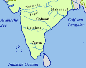
The district occupies an area of 7,742 km2 (2,989 sq mi). The district is bounded by Khammam district on the north, Bay of Bengal on the south. The Godavari River separates East Godavari district on east and Tammileru River and Kolleru Lake separates it from Krishna district on the west.[8]:22
Rivers and Topography
| S.No. | Name of the Basin | % of the Area covered |
|---|---|---|
| 01 | Godavari | 20.20% |
| 02 | Yerrakaluva | 48.10% |
| 03 | Tammileru | 26.80% |
| 04 | Ramileru | 01.40% |
| 05 | Kolleru | 3.50% |
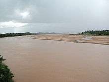
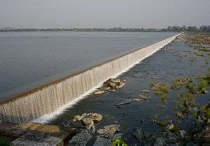
West Godavari is a flat country with a slight eastern slope along the rivers of the district flow. The rivers in the West Godavari district generally flow from West to East. Three rivers cut through the district are Godavari (after which the district is named), Yerrakaluva and Tammileru. Dowleswaram barrage, Eluru canal, Vijayarai Anicut, Tammileru, Jalleru and Yerrakaluva reservoirs are the source of irrigation.[10]
Climate
The region has a tropical climate similar to the rest of the Coastal Andhra region. The summers (March–June) are very hot and dry while the winters are fairly pleasant. The temperatures in the summers often rise over 50 degrees during the day. The rainy season (July–December) is often the best time for tourist visits, as fields are brilliantly green with paddy crops, rivers flowing with monsoon water, and a relatively cool climate. The region has long been home to the Indian nobles due to its climate and fertile soil, and several zamindar large mansions are scattered around the Godavari area.
Demographics
As of 2011 Census of India, West Godavari district has a population of 3,936,966 with 1,091,525 households, which is the 11th most populous district in the state.[8] The district population is approximately equals to the population of Liberia[11] and Oregon.[12]
In Andhra Pradesh, the West Godavari district is the 19th largest in terms of area with an area of 7,742 km2 (2,989 sq mi)(Before bifurcation) and has a population density of 509/km2 (1,320/sq mi), which is the fourth most densely populated district in the state.[8] Its population growth rate over the decade 2001-2011 was 3.45%.[13] West Godavari has a sex ratio of 1004 females for every 1000 males and stands it at eighth position. It stands at first position in terms of literacy rate in Andhra Pradesh with 26,52,389 (74.63%) literates.[3][8] 20.6% of District's population lives in Urban areas.[14]
Economy
The gross district domestic product (GDDP) is ₹45,963 crore (US$6.4 billion) and it contributes 8.8% to the gross state domestic product (GSDP). For the FY 2013-14, the per capita income at current prices was ₹86,974 (US$1,200).
Paddy, banana, sugarcane, and coconut are the main agricultural products cultivated in the district. The agriculture sector contributea ₹18,385 crore (US$2.6 billion), industries contribute ₹7,086 crore (US$990 million), and services contribute ₹20,491 crore (US$2.9 billion) to GDDP.[14] The major products contributing to the gross value added (GVA) of the district from agriculture and allied services are paddy, sugarcane, banana, coconut, milk, meat and fisheries. The GVA to the industrial and service sector is contributed from construction, electricity, manufacturing, unorganised trade, and transport.[14]
Cashew nut, mango and tobacco are other important production from the district.[10] Shrimp production is also a main activity along with pisciculture.[15] The woolen pile carpet industry in Eluru produces eco-friendly carpets from wool that are exported.[16][17]
Culture
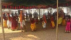
Telugu is the most widely spoken language.[15] Vedas, which has oral heritage recognition from by UNESCO are taught at Sri Venkateswara Veda Patasala of I.Bhimavaram village in the district.[18] The district is well known for its wool-pile carpets and hand woven products.[19]

Tourism and landmarks
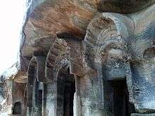
There are many landmarks and tourism destinations in the district. Eluru is the largest city of the district with many destinations related to Buddhists and Archeological importance such as Guntupalli Caves near the city.[20] Eluru city hosts 74feet high Buddha statue in the heart of the city.

Some of the religious destinations include, Dwaraka Tirumala known with the name as Chinna Tirumala,[21] Pancharama Kshetras of Palakollu and Bhimavaram etc.[22] Other destinatins of tourism importance are Perupalem Beach at Narasapuram, the Kolleru Lake being the largest fresh water in the country and a bird sanctuary,[23] Dowleswaram Barrage and Godavari river etc.
Administrative divisions

The district has five revenue divisions, namely Eluru, Jangareddigudem, Kovvur, Kukunuru and Narasapuram. These revenue divisions are divided into 48 mandals in the district. These 48 mandals consists of 881 villages, 1 municipal corporation, 8 municipalities and 5 census towns. Eluru is the only municipal corporation, 7 municipalities include, Kovvur, Narasapuram, Nidadavolu, Palakollu, Tadepalligudem, Tanuku, Bhimavaram, Jangareddigudem and the 5 census towns are Dwarakatirumala, Sanivarapupeta, Satrampadu, Gavaravaram and Tangellamudi.[8]:22–23,54

Mandals
The list of 48 mandals in West Godavari district under 5 revenue divisions are listed in the following table:[8]:22–23
Constituencies
There are two parliamentary and 15 assembly constituencies in the district. The parliamentary constituencies are Eluru, and Narsapuram.[24]
The Assembly constituencies are:
Transport
The total of core road network of the district is 1,224.287 km (760.737 mi). It includes, 523.081 km (325.027 mi) of existing and a proposed length of 701.206 km (435.709 mi).[25] Of which 108 km (67 mi) are National Highway (India) and 281 km (175 mi) are State Highways.
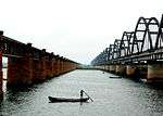
The district relies mostly on public transport such as, buses of APSRTC operating from all parts of the district. Most of the major highways and national highways pass through major towns in the district such as, AH 45, NH-16, NH-214A. South Central Railway division of Indian Railways operates many passenger and freight transport. Howrah-Chennai main line, Vijayawada–Nidadavolu loop line, Bhimavaram-Nidadavolu section, Bhimavaram–Narasapuram branch lines are the major lines and sections that provide rail connectivity in the district.
There are no air transport in the district, but has water transport. National Waterway 4 passes through the district and connects Vijayawada with Kakinada via Eluru canal. It has access to Bay of Bengal at Narsapuram.
Education
The primary and secondary school education is imparted by government, aided and private schools, under the School Education Department of the state.[26][27] As per the school information report for the academic year 2015-16, there are a total of 4,408 schools. They include, 19 government, 2,664 mandal and zilla parishads, 1 residential, 1,344 private, 3 Kasturba Gandhi Balika Vidyalaya (KGBV), 208 municipal and 169 other types of schools.[28] The total number of students enrolled in primary, upper primary and high schools of the district are 522,793.[29]
Universities
- National Institute of Technology, Tadepalligudem (NIT, Tadepalligudem).
- Dr. Y.S.R. Horticultural University, Venkataramannagudem, Tadepalligudem.
- Adikavi Nannayya University Campus at Tadepalligudem.
References
- ↑ "Katamaneni Bhaskar New WG Collector". The New Indian Express. 13 July 2014. Retrieved 2 August 2014.
- ↑ "District - West Godavari". Online Portal - Government of Andhra Pradesh. Government of Andhra Pradesh.
- 1 2 "West Godavari district profile". Andhra Pradesh State Portal.
- ↑ "West Godavari". Official portal of Andhra Pradesh Government. Retrieved 13 March 2016.
- ↑ "FOCUS: WEST GODAVARI DISTRICT FORMATION DAY". Retrieved 16 August 2017.
- ↑ "Ellora - "Encyclopedia". Retrieved 16 August 2017.
- ↑ "West Godavari district profile". The Hindu. 15 April 2008. Retrieved 9 June 2015.
- 1 2 3 4 5 6 "District Census Handbook - West Godavari" (PDF). Census of India. p. 24. Retrieved 18 January 2015.
- ↑ "IRRIGATION PROFILE WESTGODAVARI DISTRICT".
- 1 2 "Ground Water Brochure, West Godavari District, Andhra Pradesh (AAP- 2012-13)" (PDF). Central Ground Water Board. Ministry of Water Resources. p. 7. Retrieved 10 February 2016.
- ↑ US Directorate of Intelligence. "Country Comparison:Population". Retrieved 1 October 2011.
Liberia 3,786,764July 2011 est.
- ↑ "2010 Resident Population Data". U. S. Census Bureau. Retrieved 30 September 2011.
Oregon 3,831,074
- ↑ "District Census 2011". Census2011.co.in. 2011. Retrieved 30 September 2011.
- 1 2 3 "Economy of West Godavari District". Andhra Pradesh Economic Development Board. Retrieved 25 April 2017.
- 1 2 Mannan, M.A (3 January 2013). "Farmers turn away from agriculture to fish farming in Andhra Pradesh". indiatoday.intoday.in. Retrieved 14 March 2016.
- ↑ Nagaraja, G (20 March 2014). "Handmade carpet industry in doldrums". The Hindu. Retrieved 26 November 2015.
- ↑ Sajnani, Manohar (2001). Encyclopaedia of tourism resources in India. New Delhi: Kalpaz Pub. p. 66. ISBN 978-81-7835-018-9. Retrieved 26 November 2015.
- ↑ "President inaugurates TTD's veda patasala in A.P." The Hindu. Akiveedu (West Godavari district). 25 December 2015. Retrieved 14 March 2016.
- ↑ Babu, A. Satish (2008). Tourism development in India : a case study. New Delhi: A.P.H.Pub.Corp. p. 87. ISBN 978-81-313-0346-7. Retrieved 16 August 2017.
- ↑ "Guntupalli caves are selected as India's top 30 heritage sites".
- ↑ "Lord Venkateswara Temple".
- ↑ "Someswaralayam in Bhimavaram".
- ↑ "Kolleru Lake gets facelift".
- ↑ http://ceoandhra.nic.in/Right%20to%20Infn.Act/annex1.htm District-wise Assembly-Constituencies in Andhra Pradesh
- ↑ ":: APRDC ::". Andhra Pradesh Road Development Corporation. Roads and Buildings Department. Retrieved 9 November 2016.
- ↑ "School Education Department" (PDF). School Education Department, Government of Andhra Pradesh. Retrieved 7 November 2016.
- ↑ "The Department of School Education - Official AP State Government Portal". www.ap.gov.in. Retrieved 7 November 2016.
- ↑ "School Information Report". Commissionerate of School Education. Government of Andhra Pradesh. Retrieved 8 November 2016.
- ↑ "Student Information Report". Commissionerate of School Education. Child info 2015-16, District School Education - Andhra Pradesh. Retrieved 8 November 2016.
External links
| Wikimedia Commons has media related to West Godavari district. |
Places adjacent to West Godavari district | ||||||||||
|---|---|---|---|---|---|---|---|---|---|---|
| ||||||||||